Browse Listings

Parte orientale della China.. / Parte occidentale della China. (2 sheets)
The map depicts the eastern part of China with Korea -correctly- as a peninsula. Formosa is included as well. Japan is partly visible i.e. the area of Yamaguchi, strait K...
Place & Date: Venice, 1695

Carte de l'Ile de Java.
An inset plan of Batavia and clearly indicated rice fields, mountains, forests, towns in profile and even elephants suggest the wealth of detail found on this map. Modele...
Place & Date: Amsterdam, 1720

L'Empire de la Chine. . .
Detailed map of China, Korea and Taiwan. The large title cartouche is resplendent in the French style with musicians, a dancer, and various accouterments representative o...
Place & Date: Paris, dated 1750
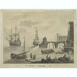
Les environs d'Ostende. XII.
Beautiful view of Oostende. A somewhat fanciful depiction of the harbor of Oostende, with merchant on the foreground and large vessels in the sea. The item is signed (Dre...
Place & Date: Belgium, c. 1811
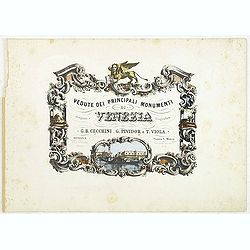
(Title page) Vedute dei principali monumenti di Venezia.
Decorative title page with in the lower part small inset view of Doge Palace, St. Marco and a gondola.
Place & Date: Venice, 1860

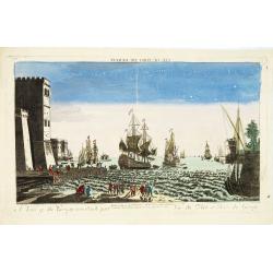
Vue et Description de Quelques-Uns des Principaux Forts des Hollandois dans les Indes .
Interesting sheet with seven detailed views illustrating the most important Dutch V.O.C. trading outposts and fortified colonial possessions in the East Indies, including...
Place & Date: Amsterdam, 1720

Kiepert's Physikalische Wandkarten. VI. Nord-America.
Large folding school wall map of North and Central America printed in chromo-lithography. Published by Dieter Reimer and printed by Leopold Kraatz in Berlin. Three inset...
Place & Date: Berlin, Dieter Reimer, 1864

Carte générale de L'Empire Ottoman en Europe et en Asie dressée par Henri Kiepert . . .
Large School wall map of Turkish Empire printed in chromo-lithography. Published by Dieter Reimer and printed by Ferdind Barth in Berlin. This rare map has two insets in ...
Place & Date: Berlin, Verlag von Dietrich Reimer, 1867

Wandkarte von Europa von H.Berghaus. . .
Large wall map of Europe printed in chromo-lithography. Prepared by Heinrich Berghaus and published by Justus Perthes in Gotha.Heinrich Berghaus, with support of Alexande...
Place & Date: Gotha, Perthes, ca.1885
![[Printed on silk] Nieuw Wassende Graaden Paskaart Vertoonende alle de bekende Zeekusten en Landen op den geheelen Aard Boodem of Werelt door Gerard van Keulen. . .](/uploads/cache/31640-250x250.jpg)
[Printed on silk] Nieuw Wassende Graaden Paskaart Vertoonende alle de bekende Zeekusten en Landen op den geheelen Aard Boodem of Werelt door Gerard van Keulen. . .
A very scarce and beautiful chart on Mercator's projection printed on silk. With the name of Gerard van Keulen and the privilege. The map shows great interior detail, inc...
Place & Date: Amsterdam, 1728

Carta terza Generale del' Asia.
Rare first state of this important chart showing part of the north coast of New Guinea and islands of the Pacific Ocean. To the north of Japan the landmass of Isola di Ie...
Place & Date: Florence, 1646

Vaisseau du premier rang portant pavillon d'amiral.
Fine double-page engraved plate of a naval vessel, with the various parts of the ship numbered and identified. From Mortier's "Neptune François". From Mortier'...
Place & Date: Amsterdam, 1695
Coupe d'une galère avec ses proportions - Quille d'une Galere sur le chantier.
Fine double-page engraved plate of a cutaway of a standard late 17th-century French galley with a detailed legend of parts (in French). Below is a representation of the k...
Place & Date: Amsterdam, 1695
Echelle pour trouver les jours de la semaine. . . / Scale om de Dagen van de Week te vinden. . . / Scale to find the Days of the Week. . .
Fine engraved plate showing eight different scales with explications in French, Dutch and English.Scale om de dagen van de week, de verschietende feest-dagen, de maan-tyd...
Place & Date: Amsterdam, 1695

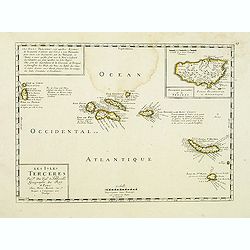
Les Isles Terceres. . .
Uncommon map of the Azores. Engraved by Sommer. Du Val is mentioned as the cartographer and the publisher was Pierre Mariette.
Place & Date: Paris, c. 1650 - 1676
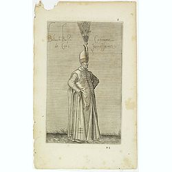
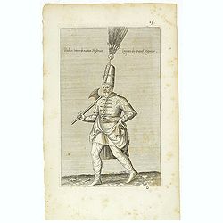
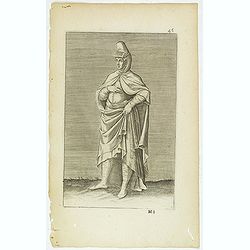
Boluch Bassi Capitaine de Cent Janissaires. (6)
Sought-after copper engraved plate from Laonikos Chalcocondyle’s "L'histoire de la décadence de l'empire grec et establissement de celuy des Turcs." by Thoma...
Place & Date: Paris, Mathieu Guillemot, 1650
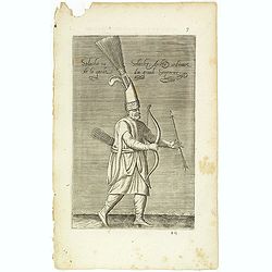
Solachi ou Solacler, Archer Ordinaire de la Garde du Grand Seigneur. (7)
Sought-after copper engraved plate taken from Laonikos Chalcocondyle’s "L'histoire de la décadence de l'empire grec et establissement de celuy des Turcs." by...
Place & Date: Paris, Mathieu Guillemot, 1650
Iannissaire ou Ianissarler Soudart a Pied de la Garde Ordinaire du Grand Seigneur. (8)
Sought-after copper engraved plate from Laonikos Chalcocondyle’s "L'histoire de la décadence de l'empire grec et establissement de celuy des Turcs." by Thoma...
Place & Date: Paris, Mathieu Guillemot, 1650

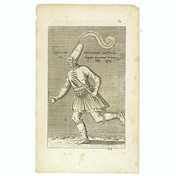
Iannissaire Allant à la Guerre. (9)
Sought-after copper engraved plate from Laonikos Chalcocondyle’s "L'histoire de la décadence de l'empire grec et establissement de celuy des Turcs." by Thoma...
Place & Date: Paris, Mathieu Guillemot, 1650
Azamoglan Rustique .(12)
Sought-after copper engraved plate taken from Laonikos Chalcocondyle’s "L'histoire de la décadence de l'empire grec et establissement de celuy des Turcs." by...
Place & Date: Paris, Mathieu Guillemot, 1650
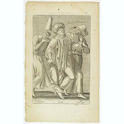
Peich ou Peider de Nation Persienne Laquais du Grand Seigneur. (13 )
Sought-after copper engraved plate taken from Laonikos Chalcocondyle’s "L'histoire de la décadence de l'empire grec et establissement de celuy des Turcs." by...
Place & Date: Paris, Mathieu Guillemot, 1650
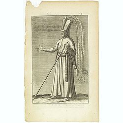
Habit et Manière ancienne des Peiches ou Laquais du Grand Seigneur. (14)
Sought-after copper engraved plate taken from Laonikos Chalcocondyle’s "L'histoire de la décadence de l'empire grec et establissement de celuy des Turcs." by...
Place & Date: Paris, Mathieu Guillemot, 1650
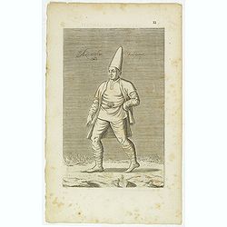
Les Yurongnes. (18)
Sought-after copper engraved plate taken from Laonikos Chalcocondyle’s "L'histoire de la décadence de l'empire grec et establissement de celuy des Turcs." by...
Place & Date: Paris, Mathieu Guillemot, 1650
Torlaqui Religieux Turc. ( 25 )
Sought-after copper engraved plate taken from Laonikos Chalcocondyle’s "L'histoire de la décadence de l'empire grec et establissement de celuy des Turcs." by...
Place & Date: Paris, Mathieu Guillemot, 1650
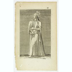
(Grand dame Turque. 45)
Sought-after copper engraved plate of a woman from Turkey. Plate from Laonikos Chalcocondyle’s "L'histoire de la décadence de l'empire grec et establissement de c...
Place & Date: Paris, Mathieu Guillemot, 1650
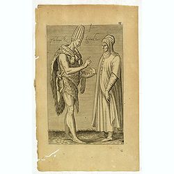
Femme Persienne. (59)
Sought-after copper engraved plate of a woman from Persia. Plate from Laonikos Chalcocondyle’s "L'histoire de la décadence de l'empire grec et establissement de c...
Place & Date: Paris, Mathieu Guillemot, 1650

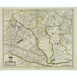
Marcomania hoggidi Merchesato de Moravia. . .
Although Komensky's map of Moravia was already known in his time, Coronelli used the obsolete map by Fabricius, with a lot of locations added by the publisher's unchained...
Place & Date: Venice, 1696

La Pologne Dressée sur ce qu'en ot donné Starovolsk, Beauplan, Hartnoch. . .
Large map of Poland, Lithuania, Belarus and part of Ukraine. The map is filled with detail and decorated with a title cartouche flanked by mythological figures.According ...
Place & Date: Paris, 1773 - 1780

Carte de la Hongarie a l'Autriche. .
A detailed and scarce map showing Hungary and Austria engraved by de François Lapointe (Lépine). Dated 1664.With a dedication to Ferdinand-Ernest Comte d'Abensperg-Trau...
Place & Date: Paris, 1676

Grande Pologne et Prusse avec les frontières de la Misnie, Lusace, Moravie et Lithuanie.
Detailed map of Poland and Prussia. Published by Pieter van der Aa who published a.o. "Naauwkeurge versameling der gedenkwaardigste zee- en land-reysen", a seri...
Place & Date: Leiden, 1729

Teatro della guerra nelle Flandre Austriache e Francesi. . .
Rare folio-sized map of Belgium by Antonio Zatta e Figli, from a never-finished atlas by the ‘Società Calcografia’, a partnership of the two main Venetian publishers...
Place & Date: Venise, 1803

Iunan, Queichev, e Quangsi Provincie della Cina. . .
A beautiful map depicting the area of Beijing with decorative title cartouche and scale cartouche. Information about the area at the top of the map.The remarkable Vincenz...
Place & Date: Venice, 1690

Venise. 1700
Extremely rare panoramic broad sheet panoramic town-view of Venice with underneath in letter press a description of the town's history. The view measures more than 1 mete...
Place & Date: Paris, 1699

Bowles's new four-sheet map of England and Wales. . .
Bowles's new four-sheet map of England and Wales: Comprehending all the Cities, Boroughs, Market and Sea-Port Towns, Villages, Lakes, Rivers, Forests, Ruins, Canals, and ...
Place & Date: London, 1801

Constantinopolitanae urbis effigies ad vivum expressa, quam Turcae Stampoldam vocant. A° MDCXXXV.
Large, decorative view of the city of Constantinople, with legend across the bottom. It is beautifully engraved with quaint scenes of everyday life, including hunters wit...
Place & Date: Frankfurt, 1635

Het Huisje door Czaar Peter den Grooten in den Jare 1697 te Zaandam bewoond.
Engraved by Cornelis van Baarsel (Utrecht 1761 - Amsterdam 1826-08-17) after a design of T. Monsieur M.Z. who made his drawing "after nature".A first state, the...
Place & Date: Zaandam, 1823

Tractus Danubii, Fluminis in Europa Maximi, A Fontibus, Per Germaniam. . .
This is Blaeu’s first map of the Danube and surrounding regions. The Danube River runs through the map from the top left with its headwaters in the German Black Forest ...
Place & Date: Amsterdam, 1634

Carte nouvelle de Moscovie represente la partie Septentrionale dressée par G.De L'Isle. . .
Uncommon map covering the area north of Moscow, including Lapland. Prepared by G. de L'Isle.Joachim Ottens (1663 - 1719) and his sons Renier and Joshua were prominent Dut...
Place & Date: Amsterdam, 1720
Hungaria regnum.
Detailed map of Hungary. First edition of Sanson's map of the Kingdom of Hungary. Engraved by A. Peyrounin.
Place & Date: Paris, ca. 1640

Franconiae nova descriptio.
Second state of this early map of Franken, including Regensburg, Heidelberg, Marburg and Hof. In lower part decorative cartouches and upper right a dedication to Franz vo...
Place & Date: Amsterdam, after 1646

Comitatus Zutphania.
A very detailed map of this area, including Arnhem, Nijmegen, Zutphen, Groenlo, etc. First imprint, from a Latin edition of the scarce Atlas Appendix.
Place & Date: Amsterdam, 1637

Ducatus Limburg.
A very rare issue of this map of Limburg. Cornelis Danckerts II. copied the folio map of H.Hondius.The publisher's address was placed in the lower right-hand corner. The ...
Place & Date: Amsterdam, 1636

Cazal. (Casale Monferrato)
A rare panoramic of Casale Monferrato in the Piedmont region. Engraved by Pierre Aveline (Paris, c.1656 - 23 May 1722). He was also a print-publisher and print-seller. H...
Place & Date: Paris, 1690-1730

Carte des Possessions Françoises et Angloises dans le Canada et partie de la Lousiane. . .
Proof state. Here without the decorations around the title cartouche in the what is called in the reference books the first state the cartouche in upper left . No double ...
Place & Date: Paris, 1756

Dynastiae Comitat. Schoenburgici Penig, Remissa, Rochsburg, Wechselburg In Clientela Elect: Saxon Glaucha, Hartenstein, Lichtenststein, Walkenburg. . .
A very uncommon and superbly decorative map of Lower Saxony, the region southwest of Dresden. Including the towns of Rochlitz, Geringswalde, Mittweida, Frankenberg, Chemn...
Place & Date: Augsburg, 1750

ANTIBES, Ville et Port de Mer de Provence, sur la Mer Mediterranée.
Early plan of Antibes. From his "Introduction à la fortification".
Place & Date: Paris, 1693

St Tropez.
Early plan of St.Tropez. From his "Introduction à la fortification".
Place & Date: Paris, 1693
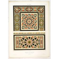
![Art arabe. - [No tittle]](/uploads/cache/32750-250x250.jpg)
Art arabe. - [No tittle]
Lithographed by Daumont. From the author's "L'Art Arabe d'après les monuments du Kaire...". Emile Prisse d'Avennes, Orientalist and Muslim convert, obsessive i...
Place & Date: Paris, 1877
Art arabe. - Mosquée d'el-Bordeyny. . .
Lithographed by Daumont. From the author's "L'Art Arabe d'après les monuments du Kaire…". Emile Prisse d'Avennes, Orientalist and Muslim convert, obsessive i...
Place & Date: Paris, 1877

Parte settentrionale dell' Irlanda / Irlanda parte meridionale . . .
A beautiful and flamboyantly engraved grand two-sheet map of Ireland. Embellished with two cartouches, a vessel under sail and a sea monster.The map is the product of the...
Place & Date: Venice, 1696

Norlandiae et quibies Gestricia et Helsingicae regiones Auct: Andrea Buraeo Sueco.
Uncommon map prepared by Anders Bure (1571-1646) with a dedicational cartouche to Gabriel Bengtsson Oxenstierna.The Atlas Maior is the epitome of decades of achievement b...
Place & Date: Amsterdam, 1662

Nouvelle et exacte description du globe terrestre reveue corrigée et augmente´e suivant les derniéres relations des Anglais et Hollandois. Par Guillaume Blaeu 1645.
Extremely rare and decorative "carte a figures" world map published by Anthoine de Fer. The double hemisphere world map is surrounded by constellations of the A...
Place & Date: Paris, 1645

Le Nouveau et Curieux Atlas Geographique et historique, ou Le Divertissement des Empereurs, Roys, et Princes. Tant dans la Guerre que dans la Paix. Dédié A Son A.R. Monseigneur le Duc d'Orléans Regent du Roîaume de France.
Charming world atlas with double hemisphere world and the North American map feature the Island of California. In Asia and the Pacific, Australia is incompletely mapped a...
Place & Date: Paris, 1719

Singapore.
Chart of Southern part of Malaysian peninsular showing good detail on of Singapore. Map with legend and scale.
Place & Date: London, 1944
Abrahamus Ortelius Antuerpianus cosmographus natus a. MDXXVII
Portrait of Abraham Ortelius (Abraham Ortel), famous cartographer born in Antwerp and after studying Greek, Latin and mathematics set up a business there with his sister,...
Place & Date: Antwerp, c.1650
Selling price: $225
Sold in 2023

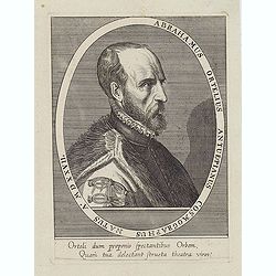
ABRAHAMUS ORTELIUS ANTVERPIANUS Orteli dum proponis spectantibus Orbem, Quam tua delectant structa Theatra homines! . . .
Portrait of Abraham Ortelius (Abraham Ortel), famous cartographer born in Antwerp and after studying Greek, Latin and mathematics set up business there with his sister, a...
Place & Date: Antwerp, c.1595
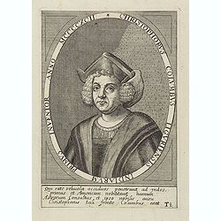
Christophorus Columbus Liguriensis Indiarum Primus Inventor Anno MCCCCXCII.
Portrait of Christopher Columbus (c. 31 October 1451 – 20 May 1506), explorer, colonizer, and navigator, born in the Republic of Genoa, in north-western Italy. Under th...
Place & Date: Antwerp, c.1700
Selling price: $200
Sold in 2023
![Schat-Kamer ofte konst der stuurlieden, behelzende een duidelyke onderwyzinge in de navigatie. . . [bound with] Tafelen bevattende De Sinussum, tangenten en Secanten. . . [bound with] Geographische Tadfel...](/uploads/cache/33112-250x250.jpg)
Schat-Kamer ofte konst der stuurlieden, behelzende een duidelyke onderwyzinge in de navigatie. . . [bound with] Tafelen bevattende De Sinussum, tangenten en Secanten. . . [bound with] Geographische Tadfel...
Schat-Kamer ofte konst der stuurlieden, behelzende een duidelyke onderwyzinge in de navigatie. . . [bound with] Tafelen bevattende De Sinussum, tangenten en Secanten. . ....
Place & Date: Amsterdam, J. v. Keulen en Zoonen, 1777
![Schat-Kamer ofte konst der stuurlieden, inhoudende Een duidelyke onderwyzinge in de navigatie. . . [bound with] Geographische Tadfel vande Graaden.. Voornaamste Zee-haavens. . .](/uploads/cache/33114-250x250.jpg)
Schat-Kamer ofte konst der stuurlieden, inhoudende Een duidelyke onderwyzinge in de navigatie. . . [bound with] Geographische Tadfel vande Graaden.. Voornaamste Zee-haavens. . .
Rare and important manual originally prepared by Klaas de Vries and improved by Evert Floryn and S.Hollander of the "Schat-Kamer ofte konst der stuurlieden" (Tr...
Place & Date: Amsterdam, Wed. Gerard Hulst van Keulen, 1802

Vue du village de Maarsen en Hollande.
Showing the river Vecht at the town of Maarsen. Published by Jacques Chereau, who was a well-known publisher of optical prints, established in rue St. Jacques in Paris. I...
Place & Date: Paris, ca. 1750

Sexta Etas Mundi. Folium. CCXVII (dancers of Maastricht).
Latin text page with woodcuts of male Siamese twins, a man headed lion. The large illustration is the only illustration related to the Netherlands : it shows a bridge col...
Place & Date: Nuremberg, 12 July 1493

Vue perspective de l'interieur de la Salle du spectacle de Veronne en Italie.
Showing the Opera of Verona. Optical print published Mondhare, who was a well-known publisher of optical prints, established in rue St. Jacques in Paris. In the eighteent...
Place & Date: Paris, ca. 1780

Vue perspective edu fauxbourg et du port de Scheveningue a une lieue de la Haye, en Hollande.
Optical print showing the village and harbor of Scheveningen with the church at the right, in the background the North Sea. In the background the summer residence Nieuw S...
Place & Date: Paris, ca. 1750
A view of the Gerzay near Iside part. / Vue du port et rade de Gerzay.
A fanciful depiction of the port of Jersey. Engraved by the French engraver Paul Angier after a design by P.Brookes and published by Robert Sayer of London, a well-known ...
Place & Date: London, ca. 1760

A view of Amsterdam taken from the Old Rampart.
So-called optical print of Amsterdam, published by Jean Mondhare after a print by Laurie and Wtitle. With captions in English and French above and belowIn the eighteenth ...
Place & Date: Paris, ca. 1760

Veduta della Piazza della SS. Nunziata, Statua Equestre di Ferdinando Primo, Fonti, e Loggie Laterali.
Lively view of Nunziata square with the statue of Ferdinand I in Florence after Giuseppe Zocchi (1711or 1717 - 1767) and engraved by B.Sgrilli. From "Scelta di XXIV ...
Place & Date: Florence, Bouchard, 1754

Map of the Great Salt Lake And Adjacent Country in the Territory Of Utah. Surveyed in 1849 and 1850, under the orders of Col. J.J. Abert ...
Map of the Great Salt Lake And Adjacent Country in the Territory Of Utah. Surveyed in 1849 and 1850, under the orders of Col. J.J. Abert .. by Capt. Howard Stansbury .. a...
Place & Date: Ackerman, New York, 1852

Le comte de Namur et partie des Duchez de Brabant. . .
Decorative map centered on Namen and including the towns of Liege, Leuven, Charleroi, Dinant, Luxemburg, etc. by François Jollain (ca. 1641 – 18 April 1704).Rare "...
Place & Date: Paris, c. 1692

Carte du Palatinat du Rhin.
Decorative "carte à figures"- map centered on Koblenz, Metz, Strasburg, Manheim and Heidelberg, with the river Rhine by François Jollain (ca. 1641 – 18 Apri...
Place & Date: Paris, ca. 1688

Les vallées du Piemont. Habitees par les Vaudois ou Berbets. . .
Detailed map of Piedmont region covering French and Italian territories. Surrounded by a French text description "Description des vallées du Piemont qu'habitent par...
Place & Date: Paris, 1690
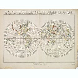
Mappe-Monde, ou Carte Generale du Monde: Dessignée en deux plans Hemispheres Par le Sr. Sanson d'Abbeville, Geographe ordinaire de sa Majesté.
Sanson's first world maps, dated 1651 and 1652, were issued separately and then in collections of mapsThe map is one of the first to distinguish the Great Lakes, all five...
Place & Date: Paris, 1651

Veue de la Ville, et du Port de Calais, di côte de la terre.
Showing the town of Calais; landscape with, in the left foreground, group of cavalrymen led by an officer and going to right, at right two soldiers walking alongside a ca...
Place & Date: Paris, ca. 1680

Carte de la France Divisée en 83 Départements et Subdivisée en districts avec les Chefs-lieux de Cantons Présentée à l'Assemblée Nationale et au Roi.
Spectacular folding wall map of France engraved by Barrier. Panels on both sides: "Tableau de la Division de la France d'après les décrets de l'Assemblée national...
Place & Date: Paris, Belleyme, 1791
![[Map of the Holy Land, including Cyprus]](/uploads/cache/33436-250x250.jpg)
[Map of the Holy Land, including Cyprus]
Attractive full page longitudinal map of Palestine, Syria and Cyprus, cut by Hans Rudolf Manuel Deutsch. The shore line running from Southern Anatolia to the Nile Delta. ...
Place & Date: Basle, 1550-1580

De Zype. / Purmer / Wormer/ Beemster / Waterland.
Five maps on one sheet. Showing the polders of De Zype, De Purmer, De Wormer, De Beemster and a map of Waterland, including de Bylmermeer and Monnekedam. Showing the Noor...
Place & Date: Amsterdam, 1652-1658

Carro, che uà à vela Su le Piagge di Schevelingue.
Italian version of Prince Maurits' sailing carriage designed by Simon Stevin. The big sailing-carriage could seat 28 persons and could reach a speed of seven miles per ho...
Place & Date: Venice, 1707

Il Cuscho citta principale della provincia del Peru.
A very desirable and scarce item of this decorative and early bid's-eye town-plan of the Inca city of Cuzco. Several figures shown inside the city walls and on the hillsi...
Place & Date: Lyons, 1564
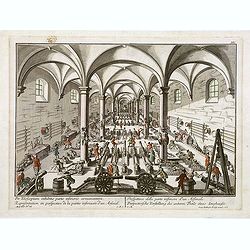
Per telecopium exhibitio partis inferioris armamentarii. / Representation en perspective de la partie inferieure d'un arsenal. . .
RARE. Engraved optical print by Georg Balthasar Probst of a arsenal.
Place & Date: Augsburg, 1750

Peregrinations divi Pauli Tyrus Corographicus. . .
A beautifully executed and very rare map showing the peregrinations of St. Paul in the Eastern Mediterranean. The Mediterranean is ornated with two ships and two sea mons...
Place & Date: Paris, ca. 1640

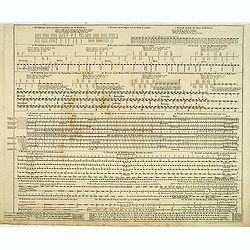
Tableau des guerres de Frédéric le Grand: ou plans figurés de vingt-six batailles rangées, ou combats essentiels donnés dans les trois guerres de Silésie. . .
The book includes a large folded map "Tableaux des Guerres de Frédéric le Grand", showing a map of Prussia, with present-day Poland and Eastern Germany surrou...
Place & Date: Potzdam, Strasbourg, Paris, 1788