Browse Listings
Globe terrestre d'après les découvertes..
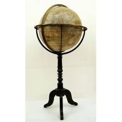
Attractive and large (height 112cm) library globe by a prominent Paris globe maker, with a brass meridian circle, horizon ring and hour ring, supported by four brass quad...
Place & Date: Paris, ca. 1885

Carte de la Coste de La Rochelle a Brouaige et de l'Isle d'Oleron Observee par le S.r de Chattillon ingenieur du Roy.
Map of the island of Oléron, with an inset in lower left corner showing the route of an English fleet to La Rochelle. At the time of mapping the area was a stronghold of...
Place & Date: Paris, 1627

'T Eilandje Desima verblyf plaats der Hollanders in Japan.
Bird's-eye view of Dejima copied from a manuscript by Voogt, who was second-in-command on Deshima in 1713. The island is viewed from the landside, depicting the developme...
Place & Date: Amsterdam, 1739

Plan de la Ville et Port d'Antibes.
An attractive chart centered on the Mediterranean. With a scale and large compass-rose. Dated 1727, with the privilege of the King. From : Recueil des Plusieurs plans des...
Place & Date: Marseille, 1730
![Carthage, etc. [Foliu XL ]](/uploads/cache/26122-250x250.jpg)
Carthage, etc. [Foliu XL ]
VERSO: Portraits of scholars, and an imaginary view on Carthage in Tunisia (12x17cm.) Page from the famous Liber chronicarum of Hartmann-Schedel 1493, the first and Latin...
Place & Date: Nuremberg 12 July 1493

Canibales Insulae.
Rare, early Dutch nautical chart of the Caribbean from Puerto Rico southward.
Place & Date: Amsterdam, 1670

Manuscript map of the Bay of Nagasaki.
An extremely rare manuscript chart in brown ink and wash color on a printed sheet of paper with a system of rhumblines and latitude scales. This chart shows the Bay of Na...
Place & Date: Amsterdam, 1750

Picardie Meridionale Le Cambresis et leurs Environs.
Map showing the region of Picardie in Northern France. Including the towns of Abbeville, Amiens, Compiegne, Soisson, Chambray, etc.
Place & Date: Paris, 1737

Vue du sperbe Temple de St.Sophie .. a Constantinople.
A fanciful depiction of the Aya Sofya in Istanbul. In the eighteenth and nineteenth centuries there were many popular speciality establishments in Paris, Augsburg and Lon...
Place & Date: Paris, 1800

Matching set of four wallmaps of America, Asia, America, Europe.
Rare and decorative set of four wall maps published by Louis Charles DESNOS ( fl.1750-1770), including a border with vignettes describing native scenes. Each panel is acc...
Place & Date: Paris, 1760-1761