Browse Listings

Carte de L\'Egypte de la Nubie de L\'Abissinie. . .
Prepared by G.de l'Isle. Uncommon issue by Hendrik de Leth. Very detailed map of northeastern Africa, the Red Sea and the Arabian peninsula shows the political divisions ...
Place & Date: Amsterdam, 1740
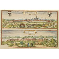
Vienna.. / Buda..
Pair of views on one sheet, the first showing the Austria capital of Vienna with fields, and figures in the foreground.Lower view shows the Hungarian capital of Budapest....
Place & Date: Cologne 1580
![Anverpia, nobile in Barbantia oppidum, parrim maritimum . . . [Antwerp]](/uploads/cache/26518-250x250.jpg)
Anverpia, nobile in Barbantia oppidum, parrim maritimum . . . [Antwerp]
The bird's-eye plan provides an excellent view of the citadel, city, docks and fortifications. The city was defended by a line of fortification and a moat constructed und...
Place & Date: Cologne, 1585

Nova et Accurata totius EUROPAE Descriptio Authore Frederico de Wit Amstelodami.
General map of Europe richly ornamented with small compass rose and Europa shown riding Zeus in the form of a bull, and several putti holding the title banner aloft.
Place & Date: Amsterdam, 1680

Alssleben.
The engraver and publisher of prints, Mrs. Anna Beek of the Hague, enlarged the print and mounted it on larger paper: she colored it in pastel colors, adding extensive cl...
Place & Date: The Hague, ca. 1700

La Tartaria Chinese.
With decorative title cartouche. Covering north eastern part of China, with good detail in Korea and a curious shape for Hokkaido (here called Jeso-Gasima ).Engraved by G...
Place & Date: Venice, 1784

Carte Geo-Hydrographique du Golfe du Mexique et de ses Isles..
Map of the Caribbean and Gulf of Mexico showing the various islands and continental coastlines according to the 18th century Venetian cartography of Rizzi Zannoni.Illustr...
Place & Date: Paris, ca 1783

Mappa Aestivarum Insularum alias Barmudas.
Blaeu based his work on John Speed's remarkably accurate map of 1626-1627. It shows the island divided into tribes and lots, and below the map itself appear the names of ...
Place & Date: Amsterdam, 1635
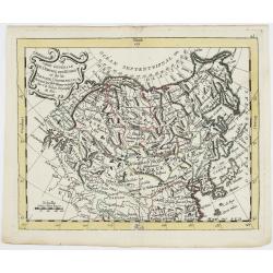
Carte Générale de l'Empire des Russes et de la Tartarie Universelle.
Rare map of Tartary and Russia, including Korea and Japan prepared after J.B.Nolin and published by Monhare for his Atlas Général a l'usage des colleges et maisons d'ed...
Place & Date: Paris, 1783
Selling price: $400
Sold in 2023

Erfolgte Kapitulation zwischen dem General Bonaparte und den Gross Leister von Malta. Vor der Hauptstadt Walette zu Maltha, am 10 Juni 1798.
Copper engraving with three scenes and one portrait on one sheet. In upper a view of Bonaparte arriving at Valletta. Published in "Allgemeine Welt-Chronik oder neue ...
Place & Date: Zittau, 1798-1800