Browse Listings
![Etats-Unis de L'Amerique Septentrionale. [Two sheets in manuscript ]](/uploads/cache/03972-250x250.jpg)
Etats-Unis de L'Amerique Septentrionale. [Two sheets in manuscript ]
Two sheets giving detailed information in French about the population in 1810, principal cities, products of industry and commerce, the financial situation for 1818, etc....
Date: France, ca. 1819

Vue de Gattweick et de l'embouchure du Rhin, dans la Mer du Nord.
Very decorative view of Katwijk. Signed lower right, Louis Bleuler au chateau de Laufen . Original design by Louis Bleuer. This gouache was the model for his aquatint in ...
Date: 1820

Chungguk-do
Chungguk-do [Map of China] taken from a Korean printed Ch’onha chido [Atlas of all under Heaven] which is a 19th century version of the traditional Korean atlas produce...
Date: Korea, ca. 1820

Manuscript plan of Havana harbour.
Manuscript chart with good nautical detail and soundings of Havana harbour.
Date: Spain c.1820

Carte générale de l' Amérique divisée en ses principaux états . . .
Map of North and South America. By C. F. Delamarche, successor of Robert de Vaugondy, Geographer. Descriptive text to the left.
Date: Paris, 1820

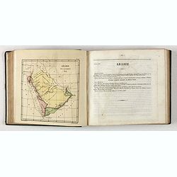
Carte de l'Arabie d'après les différents morceaux qu'a donnés M. Niebuh...
Detailed map of the Arabian Peninsula, after Niebuhr, with scales in the lower left corner. Engraved by Pierre-Paul Dubuisson.More about Mapping of Arabia [+]
Date: Paris, ca. 1820
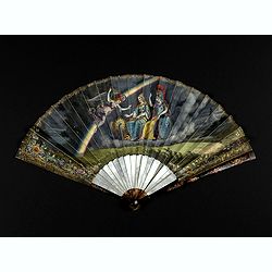
Very fine folding fan with painting of Minerva, Juno and 2 peacocks.
Small folding fan made of double skin sheet, mounted in English style, painted with gouache and depicting Minerva and Juno sitting near each other and receiving the visit...
Date: ca. 1820
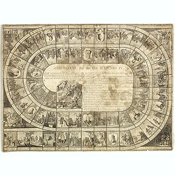
Jeu Royal de la vie d'Henri IV.
Large sheet with an animated Goose-game of 63 numbered squares, spiral, counterclockwise, centripetal focused on the French king Henri IV.André Basset offers the life of...
Date: Paris, ca. 1816-1820
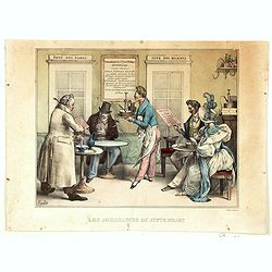
Les Jouissance du Juste Milieu.
[The Joys of the Happy Medium.] A waiter is about to serve a customer with a clyster pump and water jug. It looks as though the man has a 'menu' in one hand. On another t...
Date: Paris, ca 1820

London in Miniature With The Surrounding Villages. An Entire New Plan In which the Improvements both present and intended are actually reduced, by permission, from the surveys of the Several Proprietors. . .
Hand-coloured engraved map, dissected and mounted on linen, orange publishers label on one side, extending west to east from Kensington to East India and Greenwich Dock a...
Date: London, 1821
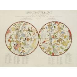
Planisferio Celeste contenente le stelle dalla 1 alla 5 grandezza. . .
Decorative large double hemisphere celestial chart, centred on the north and south poles with descriptive key to zodiac signs in German, French and Italian. Showing stars...
Date: Milan, c.1822
![[ First Separate Map of Michigan Territory ] Geographical, statistical, and historical map of Michigan territory.](/uploads/cache/25931-250x250.jpg)
[ First Separate Map of Michigan Territory ] Geographical, statistical, and historical map of Michigan territory.
The map illustrates Michigan Territory and the so-called "Indian Line" shortly after the Treaty of Chicago (1821), the third of three treaties with the Native A...
Date: Philadelphia, 1822
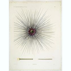
Oursins.
Decorative plate of a sea urchin, engraved by Boquet. Marie Jules César Lelorgne de Savigny (April 5, 1777 - October 5, 1851) was a French zoologist. In 1798 he traveled...
Date: Paris, 1822
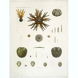
Oursins.
Showing sand dollars, sea urchin, etc. engraved by Macret. Marie Jules César Lelorgne de Savigny (April 5, 1777 - October 5, 1851) was a French zoologist. In 1798 he tra...
Date: Paris, 1822
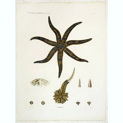
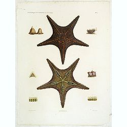
Astéries.
Decorative engraving of a star fish, engraved by Boquet. Marie Jules César Lelorgne de Savigny (April 5, 1777 - October 5, 1851) was a French zoologist. In 1798 he trave...
Date: Paris, 1822
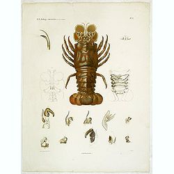
Hommards.
Decorative engraving of a lobster, by Tresca. Marie Jules César Lelorgne de Savigny (April 5, 1777 - October 5, 1851) was a French zoologist. In 1798 he traveled to Egyp...
Date: Paris, 1822
Astéries.
Decorative engraving of star fishes, by Macret and Leleu. Marie Jules César Lelorgne de Savigny (April 5, 1777 - October 5, 1851) was a French zoologist. In 1798 he trav...
Date: Paris, 1822

Het Huisje door Czaar Peter den Grooten in den Jare 1697 te Zaandam bewoond.
Engraved by Cornelis van Baarsel (Utrecht 1761 - Amsterdam 1826-08-17) after a design of T. Monsieur M.Z. who made his drawing "after nature".A first state, the...
Date: Zaandam, 1823

Map of Pensylvania and New Jersey by H.S. Tanner.
First edition of this rare and important map of Pennsylvania and New Jersey by H.S. Tanner and published in his "New American Atlas" from 1823. Includes roads, ...
Date: Philadelphia, Henry Tanner, 1823
System of Penal Law, prepared for the State of Louisiana , comprising codes of offenses and punishments, of procedure, of prison discipline, and of evidence applicable as well to civil as to criminal cases.
The "Enquiries" of Rush and Bradford and the Pennsylvania movement toward abolition of the death penalty had a little immediate impact on the practices of other...
Date: New-Orleans, Benjamin Levy, 1824
![Terre de Diemen. Grou-Agara. [plate X]](/uploads/cache/46273-250x250.jpg)
Terre de Diemen. Grou-Agara. [plate X]
A portrait of the Tasmanian Aboriginal Grou-Agara, after the original sketches by Lesueur, from Voyage de découvertes aux terres Australes by François Péron, 1824.The ...
Date: Paris, 1824
Selling price: ????
Please login to see price!
Sold in 2024
![Terre de Diemen. Arra-Maida. [plate XII]](/uploads/cache/46275-250x250.jpg)
Terre de Diemen. Arra-Maida. [plate XII]
A portrait of a female Tasmanian Aboriginal Arra-Maida, after the original sketches by Lesueur, from Voyage de découvertes aux terres Australes by François Péron, 1824...
Date: Paris, 1824
Selling price: ????
Please login to see price!
Sold in 2024
![Terre de Diemen. Habitations. [plate XV].](/uploads/cache/46278-250x250.jpg)
Terre de Diemen. Habitations. [plate XV].
An aboriginal camp fire, near the ruins of an old wooden fence, and a dead tree, after the original sketches by Lesueur, from Voyage de découvertes aux terres Australes ...
Date: Paris, 1824
![Terre de Diemen. Tombeaux des naturels. [plate XVI]](/uploads/cache/46279-250x250.jpg)
Terre de Diemen. Tombeaux des naturels. [plate XVI]
An aboriginal campfire, near the ruins of an old wooden fence, and a dead tree, after the original sketches by Lesueur, from Voyage de découvertes aux terres Australes b...
Date: Paris, 1824
![Nouvelle-Hollande. Gnoung-A-Gnougn-A, Mour-Re-Mour-Ga ( Dit Collins). [plate XVII]](/uploads/cache/46280-250x250.jpg)
Nouvelle-Hollande. Gnoung-A-Gnougn-A, Mour-Re-Mour-Ga ( Dit Collins). [plate XVII]
A portrait of a male Tasmanian Aboriginal Gnoung-A-Gnougn-A, Mour-Re-Mour-Ga ( Dit Collins) by Lesueur, from Voyage de découvertes aux terres Australes by François Pér...
Date: Paris, 1824
![Terre de Diemen. Ourlaga. [plate IX]](/uploads/cache/46272-250x250.jpg)
Terre de Diemen. Ourlaga. [plate IX]
A portrait of the female Tasmanian Aboriginal Ourlaga, after the original sketches by Lesueur, from Voyage de découvertes aux terres Australes by François Péron, 1824....
Date: Paris, 1824
Selling price: ????
Please login to see price!
Sold in 2024
![Nouvelle-Hollande: Nelle. Galles du sud - Navigation. [plate XXIII]](/uploads/cache/46345-250x250.jpg)
Nouvelle-Hollande: Nelle. Galles du sud - Navigation. [plate XXIII]
An aboriginal camp fire, with a pirogue and two men navigating , after the original sketches by Lesueur, from Voyage de découvertes aux terres Australes by François Pé...
Date: Paris, 1824
![Nouvelle-Hollande: Terre dEndracht - Cabane des naturels de la Presqu'Ile de Péron. [plate XXIV]](/uploads/cache/46346-250x250.jpg)
Nouvelle-Hollande: Terre dEndracht - Cabane des naturels de la Presqu'Ile de Péron. [plate XXIV]
An aboriginal camp fire, after the original sketches by Lesueur, from Voyage de découvertes aux terres Australes by François Péron, 1824.The French expedition under Ni...
Date: Paris, 1824
![Timor. Naba-Leba Roi de L'Ile Solor. [plate XXV]](/uploads/cache/46347-250x250.jpg)
Timor. Naba-Leba Roi de L'Ile Solor. [plate XXV]
A portrait of a male Naba-Leba by Lesueur, from Voyage de découvertes aux terres Australes by François Péron, 1824.The French expedition under Nicolas Baudin, was comm...
Date: Paris, 1824
![Timor. Canda Jeune fille Malaise. [plate XXVI]](/uploads/cache/46348-250x250.jpg)
Timor. Canda Jeune fille Malaise. [plate XXVI]
A portrait of a female Canda by Lesueur, from Voyage de découvertes aux terres Australes by François Péron, 1824.The French expedition under Nicolas Baudin, was commis...
Date: Paris, 1824
![Nouvelle-Hollande: Ile King. - L'Eléphant -marin ou Phoque à trompe. [plate XXXII]](/uploads/cache/46354-250x250.jpg)
Nouvelle-Hollande: Ile King. - L'Eléphant -marin ou Phoque à trompe. [plate XXXII]
Plate illustrating seals by Lesueur, from Voyage de découvertes aux terres Australes by François Péron, 1824.The French expedition under Nicolas Baudin, was commission...
Date: Paris, 1824
![Timor. Rhinolophe Cruménifére. [plate XXXV]](/uploads/cache/46357-250x250.jpg)
Timor. Rhinolophe Cruménifére. [plate XXXV]
Plate illustrating Horseshoe bats from Timor Island, by Lesueur, from Voyage de découvertes aux terres Australes by François Péron, 1824.The French expedition under Ni...
Date: Paris, 1824
![Nouvelle-Hollande Nelle Galles du sud. Vue d'une partie de la ville de Sydney capitale des Colonies Anglaises aux Terres Australes . . . [plate XXXVII]](/uploads/cache/46359-250x250.jpg)
Nouvelle-Hollande Nelle Galles du sud. Vue d'une partie de la ville de Sydney capitale des Colonies Anglaises aux Terres Australes . . . [plate XXXVII]
An important view of Sydney Cove from Dawes Point looking eastward from Voyage de découvertes aux terres Australes by François Péron, 1824. This is one of the earliest...
Date: Paris, 1824
![Plan de la partie sud des Iles Furneaux [with] Carte générale de la Partie Sud-Est de la Terre de Diémen . . .](/uploads/cache/46365-250x250.jpg)
Plan de la partie sud des Iles Furneaux [with] Carte générale de la Partie Sud-Est de la Terre de Diémen . . .
Two maps on one sheet, on top a map of the southern portion of Cape Barren Island, Clarke Island, and islets in the southern part of the Furneaux Group.With in lower part...
Date: Paris, 1824

The Traveller's Guide. A Map Of The Roads, Canals And Steam Boat Routes Of The United States ... Designed for the use of Travellers, By H.S. Tanner.
Rare first edition of Tanner's travel map in pocket map form, in it original red leather covers, with the map and no text, as issued. Ristow says the first edition was 18...
Date: Philadelphia, 1825

Le Chantier d'Amsterdam.
Decorative lithography representing the head quarters of the V.O.C. and shipyard in Amsterdam. The building serves nowadays as the Maritime Museum. After a painting by A....
Date: Brussels, J. B. A. Jobard, 1825

Carte Geographique, Statistique et Historique de l'Amerique Meridionale.
A nice detailed map of South America from Buchon's Atlas Gégraphique Statistique, historique et chronologique des deux Ameriques et des isles adjacentes traduit de l'atl...
Date: Paris, 1825

Carte Geographique, Statistique et Historique du Perou.
A nice detailed map of Peru from Buchon's Atlas Gégraphique Statistique, historique et chronologique des deux Ameriques et des isles adjacentes traduit de l'atlas exécu...
Date: Paris, 1825

Carte Geographique, Statistique et Historique de Buenos-Ayres.
A nice detailed map of what is today northern Argentina (Rep. of Buenos Ayres or the United Provinces of South America) from Buchon's Atlas Gégraphique Statistique, hist...
Date: Paris, 1825
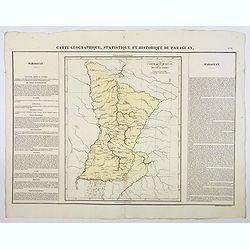
Carte Geographique, Statistique et Historique du Paraguay.
A nice detailed map of Paraguay from Buchon's Atlas Gégraphique Statistique, historique et chronologique des deux Ameriques et des isles adjacentes traduit de l'atlas ex...
Date: Paris, 1825
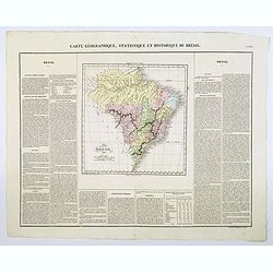
Carte Geographique, Statistique et Historique du Bresil.
A nice detailed map of Brazil from Buchon's Atlas Gégraphique Statistique, historique et chronologique des deux Ameriques et des isles adjacentes traduit de l'atlas exé...
Date: Paris, 1825
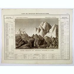
Carte des Principales Montagnes du Globe.
A nice detailed depiction of the principal mountains of the world from Buchon's Atlas Gégraphique Statistique, historique et chronologique des deux Ameriques et des isle...
Date: Paris, 1825
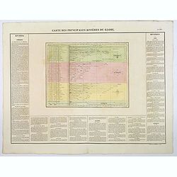
Carte des Principales Riviers du Globe.
A nice detailed depiction of the principal rivers of the world from Buchon's Atlas Gégraphique Statistique, historique et chronologique des deux Ameriques et des isles a...
Date: Paris, 1825
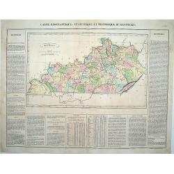
Carte Géographique .. Kentucky.
Detailed map of Kentucky. From J.A. Buchon, "Atlas Gégraphique Statistique, historique et chronologique des deux Ameriques et des isles adjacentes; traduit de l'atl...
Date: Paris, 1825
Bibliomappe. Chronologie Historique et Géographique par MM. Année et Vivien bound with : Bibliomappe, ou Livre-Cartes: Leçons Méthodiques de Chronologie et de Géographie, . . .
With 67 maps (1 folding) by A.M. Perrot. Published in Paris. Most maps have original color. The atlas is complete very rare, as it was issued in 15 separate installments ...
Date: Paris, Renard, 1827 / 1824-1826

Province de Pologne contenant 22 Col. une M.on Prof 5 Pen. 2 Nov. 6 Rés. 30 Maisons 1050 Jésuites.
Rare map of Poland from "Atlas Universel indiquant les établissemens des Jésuites: avec la manière dont ils divisent la terre, suivi desévénemens remarquables d...
Date: Paris, Ambroise Dupont , 1826

Missions et Résidences dans la Partie Septentrionale de l'Amérique Contenant 50 Jésuites.
Very rare missionary map of North America from "Atlas Universel indiquant les établissemens des Jésuites: avec la manière dont ils divisent la terre, suivi desév...
Date: Paris, Ambroise Dupont , 1826
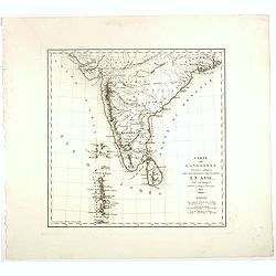
Carte De L'Indostan Servant à Indiquer Les Possessions Françaises En Asie.
Map of a part of Asia, with Sri Lanka, From " Nouvel Atlas du royaume de France, ou cartes détaillées des Gaules, de la France à l'époque de 1789, des 86 départ...
Date: Paris, 1826
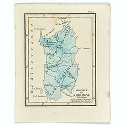
Province de Sardaigne.
Province de Sardaigne Contenant 9 Col. 1 Sem. 1 Noviciat, 2 Résidences 300 Jésuites". Publiée dans "Atlas Universel indiquant les établissemens des Jésuite...
Date: Paris, Ambroise Dupont , 1826
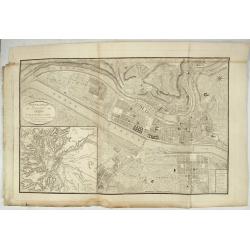
Nouveau Plan Géométral de la Ville de Lyon, Avec ses projets d'agrandissement & d'embellissement, Divisé par Arrondissements;
Large map of Lyon with, at the bottom left, a large inset depicting "The surroundings of Lyon, according to Cassini" and at the bottom right, a double table of ...
Date: Lyon, Chez Vegezzy, M.d d'Estampes,1826
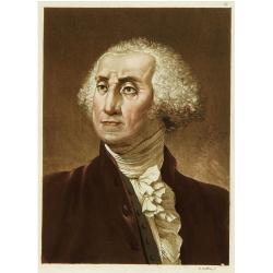
Portrait de George Washington.
Portrait of the first president of the United States of America.From Giulio Ferrario's work Le Costume ancien et moderne ou histoire du gouvernement, de la milice, de la ...
Date: Milan 1827

Les jeunes voyageurs en Europe, ou description raisonnée des divers pays compris dans cette partie du monde.
The second edition of this fine travel companion is illustrated with 16 very decorative maps, each map surrounded by local products and specialties of the region. Include...
Date: Paris, Thiériot, 1827
![[Papua New Guinea Inhabitants ].](/uploads/cache/26364-250x250.jpg)
[Papua New Guinea Inhabitants ].
Aquatint depicts three men in a pirogue engraved by Fumagalli. Plate N° 75. From Giulio Ferrario's work Le Costume Ancien et Moderne ou Histoire du gouvernement, de la m...
Date: Milan, 1827
![[The Admiralty Islands and New Britain inhabitants fishing. Papua New Guinea ].](/uploads/cache/26365-250x250.jpg)
[The Admiralty Islands and New Britain inhabitants fishing. Papua New Guinea ].
Aquatint depicting fishermen in dugouts engraved by A. Biasioli. Plate N° 14. From Giulio Ferrario's work Le Costume Ancien et Moderne ou Histoire du gouvernement, de la...
Date: Milan, 1827
![[ Traditional tools from New Caledonia ].](/uploads/cache/26366-250x250.jpg)
[ Traditional tools from New Caledonia ].
Aquatint depicting a variety of traditional tools from New Caledonia engraved by Rossi. Plate N° 72. From Giulio Ferrario's work Le Costume Ancien et Moderne ou Histoi...
Date: Milan, 1827
![[New Caledonians ].](/uploads/cache/26367-250x250.jpg)
[New Caledonians ].
Aquatint depicting New Caledonians engraved by Biasioli. Plate N° 71. From Giulio Ferrario's work Le Costume Ancien et Moderne ou Histoire du gouvernement, de la milice,...
Date: Milan, 1827
![[Pirogues in the bay of the voyage of the Resolution. The Marquesas Islands ].](/uploads/cache/26373-250x250.jpg)
[Pirogues in the bay of the voyage of the Resolution. The Marquesas Islands ].
Aquatint depicting men in pirogues in the Bay of the Resolution from the Marquesas Islands engraved by Biasioli. Plate N° 91. From Giulio Ferrario's work Le Costume Anci...
Date: Milan, 1827
![[Marquesas Islands headdresses and head ornaments ].](/uploads/cache/26374-250x250.jpg)
[Marquesas Islands headdresses and head ornaments ].
Aquatint depicting Marquesas Islanders in traditional headdresses and a variety of head ornaments engraved by Bonatti. Plate N° 90. From Giulio Ferrario's work Le Costum...
Date: Milan, 1827
![[Easter Island inhabitants ].](/uploads/cache/26375-250x250.jpg)
[Easter Island inhabitants ].
Aquatint depicting 2 portraits of Easter Island inhabitants and 2 men rowing in a pirogue. Engraved by Carlo Bottigella. Plate N° 88. From Giulio Ferrario's work Le Cost...
Date: Milan, 1827
![[Women dancing in a Ulietea house ].](/uploads/cache/26376-250x250.jpg)
[Women dancing in a Ulietea house ].
Aquatint depicting women dancing in front of musicians and local villagers in a Ulietea house. Plate N° 87. From Giulio Ferrario's work Le Costume Ancien et Moderne ou H...
Date: Milan, 1827
![[Tahitian warrior dugouts ].](/uploads/cache/26377-250x250.jpg)
[Tahitian warrior dugouts ].
Aquatint depicting a view of Tahitian warrior dugouts engraved by Fumagalli. Plate N° 86. From Giulio Ferrario's work Le Costume Ancien et Moderne ou Histoire du gouve...
Date: Milan, 1827
![[Tahitian tools ].](/uploads/cache/26378-250x250.jpg)
[Tahitian tools ].
Aquatint depicting a variety of Tahitian tools engraved by Rivelanti. Plate N° 85. From Giulio Ferrario's work Le Costume Ancien et Moderne ou Histoire du gouvernement...
Date: Milan, 1827
![Mortuary scene. Tahiti Islands ].](/uploads/cache/26380-250x250.jpg)
Mortuary scene. Tahiti Islands ].
This aquatint depicts a mortuary scene in front of a tapapow, a shed under which the dead bodies remains are exposed until they dry. Engraved by Roffi. Plate N° 83. From...
Date: Milan, 1827
![[Queen Obera welcoming Captain Wallis. Tahiti ].](/uploads/cache/26381-250x250.jpg)
[Queen Obera welcoming Captain Wallis. Tahiti ].
Aquatint depicting Queen Obera welcoming Captain Wallis upon his arrival in Tahiti. Engraved by Gallina. Plate N° 82. From Giulio Ferrario's work Le Costume Ancien et Mo...
Date: Milan, 1827
![[The Friendly Islands ].](/uploads/cache/26384-250x250.jpg)
[The Friendly Islands ].
Aquatint depicting seashore scene of the Friendly Islands. These islands are also known as the Friendly Islands because of the friendly reception accorded to Captain Cook...
Date: Milan, 1827
![[Portraits. Friendly Islands ].](/uploads/cache/26385-250x250.jpg)
[Portraits. Friendly Islands ].
Aquatint depicting inhabitants of the Friendly Islands. Plate N°79. From Giulio Ferrario's work Le Costume Ancien et Moderne ou Histoire du gouvernement, de la milice, d...
Date: Milan, 1827
![[Scene of a meeting. The Friendly Islands ].](/uploads/cache/26386-250x250.jpg)
[Scene of a meeting. The Friendly Islands ].
Aquatint depicting an indoor meeting in the Friendly Islands. Plate N°79. From Giulio Ferrario's work Le Costume Ancien et Moderne ou Histoire du gouvernement, de la mil...
Date: Milan, 1827
![[ Spitzbergen ]](/uploads/cache/27541-250x250.jpg)
[ Spitzbergen ]
Two aquatints depicting the northern coasts of the Spitzbergen engraved by Fumagalli. From Giulio Ferrario's work Le Costume Ancien et Moderne ou Histoire du gouverneme...
Date: Milan, 1827
![[ Niagara Falls ]](/uploads/cache/27543-250x250.jpg)
[ Niagara Falls ]
Two aquatints depicting the Horse Shoe Fall (also known as Canadian Falls at the top) and the Fort Schloper Fall (bottom) engraved by Biasolé. From Giulio Ferrario's wor...
Date: Milan, 1827
![[ View of an inn and a horse carriage. ].](/uploads/cache/27552-250x250.jpg)
[ View of an inn and a horse carriage. ].
Aquatint depicting a view of an inn and a horse carriage engraved by Fumagalli. Plate N°44.From Giulio Ferrario's work Le Costume Ancien et Moderne ou Histoire du gouver...
Date: Milan, 1827
![[ William Penn's treaty with the Indians in 1681 ].](/uploads/cache/27555-250x250.jpg)
[ William Penn's treaty with the Indians in 1681 ].
Aquatint depicting William Penn's treaty with the Indians in 1681, after a painting by Benjamin West.William Penn (October 14, 1644 - July 30, 1718) was founder and "...
Date: Milan, 1827
![[ A typical Timucua Indians Village ].](/uploads/cache/27559-250x250.jpg)
[ A typical Timucua Indians Village ].
Aquatint depicting a typical Timucua Indians Village engraved by Fumagalli, after Jacques LeMoyne. The Timucua of northeast Florida (the Saturiwa and Agua Dulce tribes) a...
Date: Milan, 1827
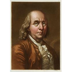
Portrait de Benjamin Franklin.
Portrait de Benjamin Franklin. From Giulio Ferrario's work Le Costume ancien et moderne ou histoire du gouvernement, de la milice, de la religion, des arts, etc. publishe...
Date: Milan, 1827

Partie de la Chine. N°.74 (Including South Korea)
Covering the Mouth of the Yangtze area in Jiangsu and Zhejiang, and southwestern Korea with the island of Quelpart (Jeju-do). Shows explorers' routes, including La Perou...
Date: Brussels, 1825-1827

Partie de la Chine N°87. (Covers Jiangxi, Fujian and parts of Zhejiang, Guangdong, Hunan and Hubei.)
Covers Jiangxi, Fujian and parts of Zhejiang, Guangdong, Hunan and Hubei.From his famous Atlas Universel . This atlas was one of the most remarkable world atlases ever pr...
Date: Brussels, 1825-1827

Partie de la Chine N°86. (Covers Guizhou and parts of Yunnan, Guangxi, Hunan, Hubei and Sichuan.)
Covers Guizhou and parts of Yunnan, Guangxi, Hunan, Hubei and Sichuan.From his famous Atlas Universel . This atlas was one of the most remarkable world atlases ever produ...
Date: Brussels, 1825-1827
![[Canadian Indian traditional garments ].](/uploads/cache/27544-250x250.jpg)
[Canadian Indian traditional garments ].
Aquatint depicting Canadian Indian traditional garments engraved by Gallina. Plate N°32.From Giulio Ferrario's work Le Costume Ancien et Moderne ou Histoire du gouvernem...
Date: Milan, 1827
![[Canadian Indians ].](/uploads/cache/27546-250x250.jpg)
[Canadian Indians ].
Aquatint depicting a group of Canadian Indians engraved by Gallina. Plate N° 33 n°1.From Giulio Ferrario's work Le Costume Ancien et Moderne ou Histoire du gouvernement...
Date: Milan, 1827
![[View of the Potomac River from Mount Vernon ].](/uploads/cache/27550-250x250.jpg)
[View of the Potomac River from Mount Vernon ].
Aquatint depicting a view of the Potomac River from Mount Vernon engraved by Fumagalli. Plate N°46.From Giulio Ferrario's work Le Costume Ancien et Moderne ou Histoire d...
Date: Milan, 1827
![[Florida Indian cooking ].](/uploads/cache/27561-250x250.jpg)
[Florida Indian cooking ].
Aquatint depicting Florida Indian cooking engraved by Fumagalli. Plate N°54.From Giulio Ferrario's work Le Costume Ancien et Moderne ou Histoire du gouvernement, de la m...
Date: Milan, 1827

