Browse Listings in Map Types
![[Title cartouche from Carte de la France]](/uploads/cache/47726-250x250.jpg)
[Title cartouche from Carte de la France]
Title cartouche from "Carte de la France", prepared by Captaine and published by Pierre D. Belleyme.
Place & Date: Paris, ca. 1789
![[Set of five maps] Carte Générale de la Terre ou Mappe Monde](/uploads/cache/41145X-250x250.jpg)
[Set of five maps] Carte Générale de la Terre ou Mappe Monde
Rare and decorative set of five wall maps of the world and the four continents, prepared by Clouet, in very fine bright contemporary coloring. Each map ca. 965 x 1230 mm ...
Place & Date: Paris and Cadiz, Mondhare, 1785-1793
![[Set of 6 maps] Charta öfver Storfurstendömet Finland på Friherre S. G. Hermelins Anstalt och Omkostnad. Sammandragen och författad af C. P. Hällström. Philos. Magister och Auscultant i Kongl. BergsColl. 1799.](/uploads/cache/34482-250x250.jpg)
[Set of 6 maps] Charta öfver Storfurstendömet Finland på Friherre S. G. Hermelins Anstalt och Omkostnad. Sammandragen och författad af C. P. Hällström. Philos. Magister och Auscultant i Kongl. BergsColl. 1799.
This is the beautiful set of key map and separate maps of Samuel Gustav Hermelins map of Finland. The maps have been engraved by Fredrik Akrel, a very skilled and product...
Place & Date: Källa: J.Strang & E.- S. Harju: Suomen karttakirja 1799

Carte des côtes du Golfe du Mexique compris entre la pointe sud de la presqu'Ile de la Floride et la pointe nord de la presqu'Ile d'Yucatan: Dresée d'après le observations et las plans des espagnols, ...
Detailed and important early chart of the Gulf Coast and Florida and dated 1800. First French edition of "the first printed [map] to show and name Galveston Bay&qu...
Place & Date: Paris, 1800

Lion and Bull made of terracotta.
Very fine terracotta figure of a lion symbolizing the continent of Africa. The Bull symbolizing Europe.The items will be dispatched in 4 wooden crates from Belgium. Pleas...
Place & Date: Netherlandisch , 1780~1800

Deutschlands Postkarte begraenzt von Oesterreich, Preussen, Frankreich, Holland, Italien und der Schweiz. . .
Detailed and important post road map prepared by Ignaz Heymann. The map shows, the Low Countries, Germany, Poland, Austria, Hungary, etc.Borders in original out-line colo...
Place & Date: Triest, 1800
![Bunken Edo oezu. [Tokyo]](/uploads/cache/12826-250x250.jpg)
Bunken Edo oezu. [Tokyo]
Based on map by Ochikochi Doin. Oriented with north to the right. An extraordinary wood block-printed town-plan now-a-day Tokyo, and a fine example of Edo cartography. Th...
Place & Date: Edo, ca. 1803

Carte Réduite Du Golphe Du Mexique Et Des Isles De L' Amérique..
A well engraved and highly detailed chart prepared by Bellin of the Gulf of Mexico and the Caribbean. In addition to a magnificent title cartouche and a color key to the ...
Place & Date: Paris dated year 17, or 1808

Carte des routes de poste de la Russie européenne, exécutée par ordre de S.E.M. le duc de Feltre ministre de la Guerre, ...
Post-route map on a scale of 1:2 500 000 made during the French campaign in Russia, which began June 24, 1812. With a table of the conventional signs and a table of conve...
Place & Date: Paris, Dépôt Général de la Guerre 1812

Manuscript plan of Havana harbour.
Manuscript chart with good nautical detail and soundings of Havana harbour.
Place & Date: Spain c.1820
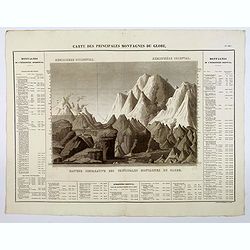
Carte des Principales Montagnes du Globe.
A nice detailed depiction of the principal mountains of the world from Buchon's Atlas Gégraphique Statistique, historique et chronologique des deux Ameriques et des isle...
Place & Date: Paris, 1825
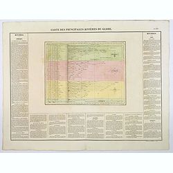
Carte des Principales Riviers du Globe.
A nice detailed depiction of the principal rivers of the world from Buchon's Atlas Gégraphique Statistique, historique et chronologique des deux Ameriques et des isles a...
Place & Date: Paris, 1825

Straat Riouw onder opzicht van de commissie tot verbetering der Indische Zeekaarten..
Very large and rare so-called Blue Back centered on the strait passing between the Riau Islands. It contains an inset map with enlarged details of Riouw Harbor on Bintang...
Place & Date: Amsterdam 1843

North Pacific.
Huge three sheet so-called Blue-back sailing chart of the Northern Pacific including China, Korea (with Matu Is. and Liancourt), Japan, Philippines, Kamchatka, Hawaii, Al...
Place & Date: London, 1868

CARTE de la Côte Occidentale de COREE, Plan Croquis de la Rivière HAN-KANG ou de SEOUL, depuis son Embouchure jusqu'à Séoul, dressée en 1866 ...
Uncommon chart of the Han-Kang River from its mouth to Seoul, prepared in 1866 by order of C.A. ROZE, Commander-in-Chief of the French " la Station des Mers de Chine...
Place & Date: Paris, 1868

L'Homme A La Boule.
Satirical print in which Count Otto von Bismarck balances on the world with one spurred foot entering France, and wearing only his underpants which are marked with the Ge...
Place & Date: Paris, 1870-1871

L'Homme A La Boule.
Satirical print in which Count Otto von Bismarck balances on the world with one spurred foot entering France, and wearing only his underpants which are marked with the Ge...
Place & Date: Paris, 1870-1871

Mer de Chine - Detroit De Singapour Partie Comprise Entre Singaour et Le Dett. De Malacca d'apres les travaux du Commr. J.W. Reed de la Marine Royale d'Angleterr, ...
A detailed chart of Singapore Strait, drawn from an English Chart by J.W. Reed, who surveyed Singapore and environs between 1865 and 1869, aboard the H.M.S. Rifleman.The ...
Place & Date: Paris, 1873

La Pieuvre Germanique.
Scarce lithographed plate not dated, by Eugène Danzanvilliers, printed by Grandremy in Paris. The plate listed by Adhemar is dated 1874. Eugène Danzanvilliers was a dra...
Place & Date: Paris, 28 Quai de la Rapée, c.1874

La pericolante ostinata. Papagallo No. 20 Anno II.
Design by Augusto Grossi. Taken from the Italian satirical newspaper Il Papagallo, a satirical magazine founded in January 1873 by Augusto Grossi (1835-1919), which speci...
Place & Date: Bologne, 1874

Trop d'Appetit par A. Le Petit.
Dated in lower right dated "Le 9 juin 1875". The drawing is representing an alligator's jaw wearing a Prussian helmet, and about to chew a globe. Alfred Le Peti...
Place & Date: Paris, 1875

Un Reclutatore in India. Papagallo No. 42. Anno VI.
British in India. Design by Augusto Grossi. Taken from the Italian satirical newspaper Il Papagallo, a satirical magazine founded in January 1873 by Augusto Grossi (1835-...
Place & Date: Bologne, 1878

La Piovra Russa. Carta Serio-Comica Pel 1878.
Very rare political caricature map by Grossi of the nations of Europe, published in Bologna in the supplement of the newspaper "Le Perroquet / Al papagallo, N° 15, ...
Place & Date: Bologne, 14 avril 1878
![Jules Verne Le Tour du Monde en 80 jours. [Goose game board inspired by Jules Verne's novel Tour du Monde en 80 jours.]](/uploads/cache/44919-250x250.jpg)
Jules Verne Le Tour du Monde en 80 jours. [Goose game board inspired by Jules Verne's novel Tour du Monde en 80 jours.]
Goose game board inspired by Jules Verne's novel, whose boxes are illustrated with color lithographs and the center occupied by a world map. Vignette illustrations number...
Place & Date: Paris, ca. 1880

Driving chart of Hartford and vicinity : 15 miles around.
Road map by Albert A. Hyde & Co. of Hartford and vicinity, with the Connecticut River in the center. Published by Albert A. Hyde & Co., in New York and lithograph...
Place & Date: New York / Philadelphia, 1884
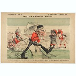
Politica Maramea Inglese - Rugantino - n°419 - Roma 17 Gennaio 1892.
Satirical print relating to the British Conquest of Egypt (1882), also known as Anglo–Egyptian War, between Egyptian and Sudanese forces under Ahmed ‘Urabi and the Un...
Place & Date: Rome, January 17, 1892
![[Soil map] Virginia-Maryland-West Virginia, Leesburg sheet.](/uploads/cache/23257-250x250.jpg)
[Soil map] Virginia-Maryland-West Virginia, Leesburg sheet.
Early color lithographed soil map by Julius Bien & Co. in New York for Department of Agriculture. Legends at side give detail on soil type, etc. They also include int...
Place & Date: New York, 1903

Excelsiori (Rana N. 28 - Cent. 20).
"After so many wars and so many troubles, young Russia, in a more serene glaze all the beautiful sun of freedom you will enjoy ... ". Fascinating allegorical sa...
Place & Date: Bologna, 1905

Atlas Geographique. (Puzzle).
Three map puzzles, each measuring 25 x 33 cm., housed in the original color printed card case. Geographical jigsaw puzzle set comprising three maps (world, Europe and Fra...
Place & Date: Paris, ca. 1910

Standford's map of the empires of China and Japan with the adjacent parts of the Russian Empire, India, Burma &c.
Charming, folding map of China and Japan with the adjacent parts of the Russian Empire, India, and Burma. A key identifies railway lines in red, projected railway lines i...
Place & Date: London, ca. 1911

Karte von Europa im Jahre 1870 nach einem französischen Holzschnitte.
Satirical illustration by Paul Hadol showing disposition of power in Europe at the beginning of 1870. Satirical print depicting a map of Europe in which the countries are...
Place & Date: Hamburg, Fuchs, 1914

Hark ! Hark ! The dogs do bark.
This very rare political caricature map of Europe depicts the continent at the outbreak of World War I, or as it was called at the time the Great War. Designed by Johnson...
Place & Date: London, Johnson Riddle & Co., 1914

Mappa Humoristico da Europa.
A really unusual and lovely map, published in Portugal at the outbreak of The Great War in 1914. This outbreak of war in Europe was the result of a complex sequence of ev...
Place & Date: Lisbon, 1914
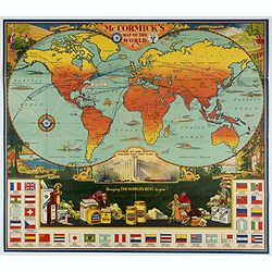
McCormick's Map of the World.
Colorful promotional map of the 20th century spice trade.What better way to showcase the global composition of a multi-national company than with a world map? This lovely...
Place & Date: United-States, 1931

Philippines Islands.
Pictorial map of Philippines Islands, from the famous illustrator, Ruth Taylor White and published in "Our USA: A Gay Geography".Ruth Taylor White was among the...
Place & Date: Boston, Little, Brown and Company, 1935

A Map and History of Peiping; formerly known as Peking; capital of provinces, princedoms and kingdoms since 1121 B.C. . .
The uncommon second edition of this very decorative and informative pictorial map of Beijing and surrounding areas whimsically illustrates the Forbidden City, essential e...
Place & Date: The Peiyang Press, Ltd. Tientsin-Peiping, 1936
![[Magazine including pictorial world map, Carriers of the New Black Plague by William Cotton.]](/uploads/cache/43680-250x250.jpg)
[Magazine including pictorial world map, Carriers of the New Black Plague by William Cotton.]
Front cover with color illustration of Moroccan male sheik and yellow lettering.Oversized magazine, features analysis of English justice, map of Herr Hitler's heaven (ful...
Place & Date: Chicago, April 7th, Vol.1 No.1 1938

Carriers of the New Black Plague.
A powerful satirical commentary on totalitarian control of speech from the first issue of Ken Magazine. "Caught here in all their peculiar beauty by the soul searchi...
Place & Date: Chicago, 1938

L'Europe en Sept 1939. Ille terrarum mihi angulus ridet.
A rare oversized serio-comic map of Europe at the start of the Second World War depicting stereotypes of 31 countries, as listed in the key lower right, including Brit...
Place & Date: Bruges, Leon Burghgraeve, 1939

Carte de la Charte de L'Antique . . .
The rare French version of this decorative pictorial world map by MacDonald Gill. "This magnificent map drawn up while the Second World War still raged is already en...
Place & Date: London, Alf Cooke Ltd, 1943

Singapore.
Chart of Southern part of Malaysian peninsular showing good detail on of Singapore. Map with legend and scale.
Place & Date: London, 1944

ADSEC in Action from Thames to Rhine.
A pictorial map showing the allied movement from London on 14 March 1944 thru the conquest of Germany. Showing the track from London along Bristol, crossing the British C...
Place & Date: London, 1945
![[Planisphère] - Crédit Lyonnais - Fondé en 1863. Afrique du Nord à Union Française.](/uploads/cache/44865-250x250.jpg)
[Planisphère] - Crédit Lyonnais - Fondé en 1863. Afrique du Nord à Union Française.
Original pictorial lithographed advertising poster showing the western part of Africa. Published by the French bank Crédit Lyonnais.Design by Lucien_Boucher who is a fam...
Place & Date: Paris, 1950

A map of the British Army with battle honours and militray achievements and Regimental Badges . . .
Shows English County Regiments, Battle Honours and Military Achievements. Bordered by Regimental Badges.A fascinating piece of British history.Read more about Pictorial M...
Place & Date: London, 1952

(World map). Americus Vespucio novo te Duce Ducta Freto Ambivi Meritoqs Vocor.
Manuscript world map showing the American and African continent and the southern parts of Asia. In the Indian Ocean a large depiction of Amerigo Vespucci 1454 – 1512) o...
Place & Date: Italy, ca. 1954

Carte géologique détaillée. Beyrouth.
Geological or soil map showing part of Lebanon with Beyrouth, including in top a colored legend with signs of the different geological ages. Provenance : Fondation P. Fal...
Place & Date: Liban, Service geographique des F.F.L., 1945.

Carte géologique détaillée. Jezzîne.
Geological or soil map showing part of Lebanon with Jezzîne, including a legend with signs of the different geological ages and giving many information of greatest inter...
Place & Date: Liban, Service geographique des F.F.L., 1945.

Carte géologique détaillée. Râchaïya Nord.
Geological or soil map showing part of Lebanon with Râchaïya , including a legend with signs of the different geological ages and giving many informations of greatest i...
Place & Date: Liban, Service geographique des F.F.L., 1945.

Carte géologique détaillée. Zahle.
Geological map showing part of Lebanon with Zahle. , including a legend with signs of the different geological ages. Provenance : Fondation P. Fallot
Place & Date: Liban, Service geographique des F.F.L., 1945.

Carte geologique detaillee. Jbail.
Geological or soil map showing part of Lebanon with Jbail antique Byblos Ancien Port phenicien / scale 1 : 50 000., including a legend with signs of the different geologi...
Place & Date: Liban, Service geographique des F.F.L., 1945.