Browse Listings in Europe > Netherlands > Gelderland > maps

Gelriae, Cliviae, Finitimorumque Locorum Verissima..
East to the top. Fine map of Geldria and Limburg, prepared by Christian s'Grooten. Very fine title cartouche lower right with painter's utensils around the cartouche. ...
Date: Antwerp, 1598
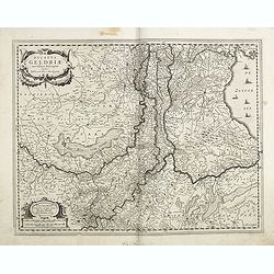
Ducatus Geldriae novissima. . .
Early map of Gelderland, but also including Utrecht, and parts of Brabant. Shows many cities (like Nijmegen, Eindhoven, Zutphen, Zwolle, etc), roads, rivers, woods, regio...
Date: Amsterdam, 1629-1630
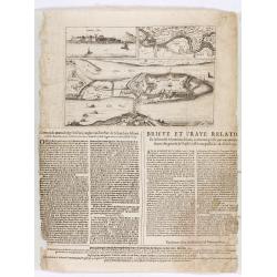
Corte ende waerachtige beschrijvinghe van het Fort de Schencken-Schans. . .
Map of the Schencken-Schans fortress printed with text. Text in Dutch and French.
Date: Antwerp, 1635

VI. Partie du Duche de Gueldre où se trouve la Veluwe.
Attractive small map covering the northwestern part of Gelderland. In the center "'t Loo". From Atlas Portatif Universel, by Robert de Vaugondy.Unrecorded state...
Date: Paris, later than 1748
