Browse Listings in Europe
![Madeburga [ Maagdenburg Folio CLXXX ]](/uploads/cache/12338-250x250.jpg)
Madeburga [ Maagdenburg Folio CLXXX ]
Double-page panoramic view of Magdeburg. An imaginary view, however, the earliest obtainable view of this period.Two pages from the richest illustrated Incunable, the fam...
Date: Nuremberg, 12 July 1493

Germania Magna (Europe continent map, folio XXVI)
1493 SCHEDEL, H. - This is the second time Iceland appears on a printed map, authored by Hieronymus Münzer. A woodcut printed map, published in 1493, in Hartmann Schedel’...
Date: Nuremberg, 1493
![Sexta Etas Mundi. Ratisbonna. [Ratisbonne]](/uploads/cache/13549-250x250.jpg)
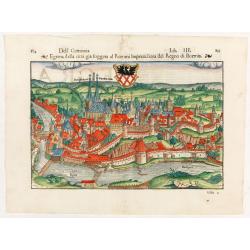
Sexta Etas Mundi. Ratisbonna. [Ratisbonne]
A very fine presentation of the city of Ratisbon, in Germany, centered on the cathedral (Dim. : 191 mm W : 525 mm).Overleaf a very nice view of Vienna, with two swans on ...
Date: Nuremberg, 12 July 1493
![Sexta Etas Mundi. Constancia. [Constance CCXLI ]](/uploads/cache/33141-250x250.jpg)
Sexta Etas Mundi. Constancia. [Constance CCXLI ]
A very fine town view of Constance, in Germany, centered on the cathedral (198 x 520 mm).VERSO, seven insets of scientists, noblemen and Popes.Page from the richest illus...
Date: Nuremberg, 12 July 1493

Sexta Etas Mundi. Folium. CCXVII (dancers of Maastricht).
Latin text page with woodcuts of male Siamese twins, a man headed lion. The large illustration is the only illustration related to the Netherlands : it shows a bridge col...
Date: Nuremberg, 12 July 1493
Selling price: ????
Please login to see price!
Sold in 2024
Tercia Etas Mundi. Folium.XLVI (An English town view)
Large woodcut depicting an imaginary English town (235x223mm.) and on the verso the genealogy of King David.Page from the richest illustrated Incunable, the famous: Chron...
Date: Nuremberg, 12 July 1493
![Venecie. [Venice] Foliu XLIIII](/uploads/cache/29716-250x250.jpg)
Venecie. [Venice] Foliu XLIIII
A very fine of Venice (192x525mm.) Verso a view of Padua. Schedel's view of Venice is one of the earliest obtainable views of the city. The view is based on the view of ...
Date: Nuremberg, 12 July 1493
![Basilae [ Basle, CCXLIIII ]](/uploads/cache/29714-250x250.jpg)
Basilae [ Basle, CCXLIIII ]
A very fine view of Basle (253x520 cm). Verso showing the councils of Florence and Basle and two portraits.Page from the richest illustrated Incunabel, the famous Nurembe...
Date: Nuremberg, 12 July 1493
![Ulma Folio CXCI [With view of Ulm.]](/uploads/cache/29713-250x250.jpg)
Ulma Folio CXCI [With view of Ulm.]
Double-page panoramic view of Ulm.An imaginary view, however, is the earliest obtainable view of this period.Two pages from the richest illustrated Incunabel, the famous ...
Date: Nuremberg, 12 July 1493
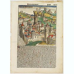
![Bamberga. Folium CLXXV [Bamberg]](/uploads/cache/47606-250x250.jpg)
Bamberga. Folium CLXXV [Bamberg]
Double page panoramic view of Bamberg. One of the earliest obtainable views of this period.Two pages from the richest illustrated Incunable, the famous Nuremberg Chronicl...
Date: Nuremberg, 12 July 1493
![Venecie. [Venice] Foliu XLIIII.](/uploads/cache/49420-250x250.jpg)
Venecie. [Venice] Foliu XLIIII.
A very fine panoramic view of Venice (192x525mm.) Verso a view of Padua. Schedel's view of Venice is one of the earliest obtainable views of the city. The view is based o...
Date: Nuremberg, 12 July 1493
![[Page with imaginary towns in Hungary. ] CCLXVIII](/uploads/cache/26932-250x250.jpg)
[Page with imaginary towns in Hungary. ] CCLXVIII
Page with imaginary towns in Hungary (230x225mm.) This leaf is from an edition of Hartmann Schedel's Liber chronicarum or Nuremberg Chronicle. The Chronicle was published...
Date: Nuremberg, 1493

Tabula Secunda Europe (Spain & Portugal)
Wood block printed large-format Ptolemaic map of the Iberian Peninsula from the 1513 edition of Waldseemüller's Geographia.This Ptolemaic map comes from the first so call...
Date: Strasburg, 1513
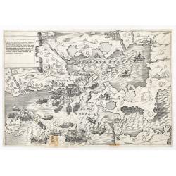
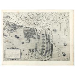
La dimostratione del luogo dove al presente sitrova l'armat di Barbarossa, et de Christiani detto il golfo dell 'Artha anti ch amente il sino ambracio…
The title cartouche at the top left reads: "La Dimostratione Del Luogo Dove Al Presente Sitrova L'Armat Di Barbarossa, et De Christiani Detto Il Golfo Dell' Artha An...
Date: Rome, c. 1540
![.[Georgia (Republic), Sarmatia, Ukraine]](/uploads/cache/33870-250x250.jpg)
.[Georgia (Republic), Sarmatia, Ukraine]
Wood block printed map and one of earliest printed representation of Georgia (Republic), Sarmatia, Ukraine prepared by Martin Waldseemüller. Based on the slightly larger ...
Date: Vienna, Trechsel, G., 1525 -1541
![.[Balkan region with Austria, Croatia, Slovenia, Switzerland, etc]](/uploads/cache/33858-250x250.jpg)
.[Balkan region with Austria, Croatia, Slovenia, Switzerland, etc]
Wood block printed map and one of earliest printed representation of Balkan with Austria, Croatia, Slovenia, Switzerland, etc prepared Martin Waldseemüller. Based on the ...
Date: Vienna, 1525 -1541
![[Europe, Eastern, Sarmatia, Ukraine]](/uploads/cache/33854-250x250.jpg)
[Europe, Eastern, Sarmatia, Ukraine]
Wood block printed map and one of the earliest printed representations of European Sarmatia, generally the region between the Baltic and Black Sea and Sea of Azov. Includ...
Date: Vienna, Trechsel, G., 1525 -1541
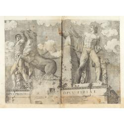
Opus Praxitelis, Opus Fidiae.
Opus Praxitelis, Opus Fidiae [Work of Praxiteles, Work of Fidias]. With the Lafreri's imprint and date. Published in the "Speculum Romanae Magnificentiae" (The ...
Date: Rome, Antonio Lafreri, 1546
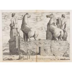
Equitum in Quirinali, aversa parte, marmorei colossi Romae; absolutissima Praxitelis et Fidiae manu.
Back view of the Dioscuri (or horse tamers, or Alexander and Bucephalus), formerly attributed to Pheidias and Praxiteles, with two figures nearby, one seated on a stone, ...
Date: Rome, Antonio Lafreri, 1550
![[Lot of 7 leaves] Curiensis civitas, Rhetorum…/Valesia/Solothurensis/Clarissimae civitatis/Genevensis/Basiliensis/Ursina…Bernensis/Sedunensis/Designatio …Badensis.](/uploads/cache/48278-250x250.jpg)
[Lot of 7 leaves] Curiensis civitas, Rhetorum…/Valesia/Solothurensis/Clarissimae civitatis/Genevensis/Basiliensis/Ursina…Bernensis/Sedunensis/Designatio …Badensis.
1552 MÜNSTER, S. - Seven text leaves illustrated with wood block bird's-eye views of Chur, Solothurn, Geneva, Basel, Bern, Sitten, Baden
Date: Basel, 1552
![[Lot of 25 leaves of France, Brabant, Netherlands, Luxemburg]](/uploads/cache/48264-250x250.jpg)
[Lot of 25 leaves of France, Brabant, Netherlands, Luxemburg]
1552 MÜNSTER, S. - Twenty-five text leaves with wood block illustrations relating to France, Brabant, the Netherlands and Luxembourg
Date: Basel, 1552
![[Lot of 2 leaves] Vienna Austriae metropolis, urbs…](/uploads/cache/48268-250x250.jpg)
[Lot of 2 leaves] Vienna Austriae metropolis, urbs…
1552 MÜNSTER, S. - Two early panoramic views of Vienna on a text page.
Date: Basel, 1552
![[Lot of 6 leaves] Civitas Augustana olim Vindelica…/Sueviae et Bavariae Descriptio/ Franckfordiae ad Oderam imago…/Franckofordianae civitatis…/Erdfordia magnifica …Thuringoru urbs…Fuldensis civitatis… / Lubecum una ex praeclarioribus. . .](/uploads/cache/48258-250x250.jpg)
[Lot of 6 leaves] Civitas Augustana olim Vindelica…/Sueviae et Bavariae Descriptio/ Franckfordiae ad Oderam imago…/Franckofordianae civitatis…/Erdfordia magnifica …Thuringoru urbs…Fuldensis civitatis… / Lubecum una ex praeclarioribus. . .
1522 MÜNSTER, S. - Six text leaves with wood block printed views and maps of Augsburg, Frankfurt /Oder, Frankfurt am Main, Erfurt and Fulda, Lübeck and a map of Swabia a...
Date: Basel, 1552
Dell Germania Egrana.
Early woodcut view of the city of Egra (Cheb) in the Czech Republic. From the 1552 Latin text edition of Münster's Cosmographia, which is a short and complete summary of ...
Date: Basel, 1552
![[Lot of 5 leaves] Noerdlinga civitas imperialis…/ Nemetum civitatis…Spiram appellant / Situs & figura… Trevirensis / Situs civitatis Confluentinae… / Civitas Lunaeburgensis…](/uploads/cache/48259-250x250.jpg)
[Lot of 5 leaves] Noerdlinga civitas imperialis…/ Nemetum civitatis…Spiram appellant / Situs & figura… Trevirensis / Situs civitatis Confluentinae… / Civitas Lunaeburgensis…
1552 MÜNSTER, S. - Five text leaves with woodblock-printed early bird's-eye views of Nördlingen, Speyer, Trier, Koblenz, and Lüneburg
Date: Basel, 1552
![[Lot of 205 leaves of Germany, Austria, Switzerland, Alsace and Brabant].](/uploads/cache/48263-250x250.jpg)
[Lot of 205 leaves of Germany, Austria, Switzerland, Alsace and Brabant].
1552 MÜNSTER, S. - 205 text leaves illustrated with wood block views and maps relating to Germany, Austria, Switzerland, Alsace and Brabant
Date: Basel, 1552
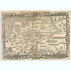
Moscovia Sigismundi Liberi Baronis In Herberstein, Neiperg et Gutehnag Anno M.D XLIX
First Modern Map of Russia. A rare and important cornerstone map for any Russian collection.One of two maps of Russia compiled by Herberstein, who was ambassador from the...
Date: Basle, 1556
![[Toscana / Tuscany] En, candidi lectores, elegantioris Italiae partis, Tusciae scilicet, topographiam. aenis nris formis excussam in hac Tabella vobis denuo damus. . .](/uploads/cache/47717-250x250.jpg)
[Toscana / Tuscany] En, candidi lectores, elegantioris Italiae partis, Tusciae scilicet, topographiam. aenis nris formis excussam in hac Tabella vobis denuo damus. . .
A rare map of Tuscany, including the islands of Elba, Giglio, Giannutri and part of Corsica, and covering the whole of Tuscany, part of Liguria, Lombardy, Emilia, Umbria,...
Date: Rome, ca 1557
![Amphitheatri Veronen[sis] diligens et accurata delineatio…](/uploads/cache/49136-250x250.jpg)
Amphitheatri Veronen[sis] diligens et accurata delineatio…
The print features the Amphitheater of Verona, it comes from "Speculum Romanae Magnificentiae" (The Mirror of Roman Magnificence). Example of the first state of...
Date: Rome, Antonio Lafreri, ca. 1560
Malita
The map includes, at the top left, a text and imprint, and, in the lower left, a scale decorated with a compass.The second state of Antonio Lafreri's map of the island of...
Date: Rome, 1565

VII. Das Ergow.
Very early wood cut printed regional map of Switzerland centered on Ergow.Originally engraved in 1548. The map was prepared by Johannes Stumpf (1500-1576). Included in &q...
Date: Zurich, Christoffel Froschover, 1548,1552-1566

III. Gallia. Franckrych.
Very early wood cut printed map of France, North of river Rhine, Northern Italy. Coast of England from Dover to Cornwall. A ship, sea monsters and coats of arms are filli...
Date: Zurich, Christoffel Froschover, 1548,1552-1566
Selling price: ????
Please login to see price!
Sold in 2025

( II Germania) / Tütschland.
Very early wood cut printed map of Germany, Poland, The Low Countries, Alsace and part Europe with of Switzerland, Croatia. Originally engraved in 1548. Included in "...
Date: Zurich, Christoffel Froschover, 1548,1552-1566

I Europa / Das dritteil der Welt.
Very early wood cut printed map of Europe with South to the top. In the lower-left corner we see Poland, Livonia and parts of England and Ireland in the lower right corne...
Date: Zurich, Christoffel Froschover, 1548,1552-1566

IX. Die Lepontier.
Very early wood cut printed regional map of Switzerland.Originally engraved in 1548. The map was prepared by Johannes Stumpf (1500-1576). Included in "Landtaflen. Hi...
Date: Zurich, Christoffel Froschover, 1548,1552-1566
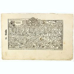
XI. Wallis.
Very early wood cut printed regional map of Switzerland with Wallis region.Originally engraved in 1548. The map was prepared by Johannes Stumpf (1500-1576). Included in &...
Date: Zurich, Christoffel Froschover, 1548,1552-1566

XII. Laurater Basler gelegenheit.
Very early wood cut printed regional map of Switzerland with Basel region.Originally engraved in 1548. The map was prepared by Johannes Stumpf (1500-1576). Included in &q...
Date: Zurich, Christoffel Froschover, 1548,1552-1566
![[Two plates on one sheet] Ordinanza Turchesa alla presa di Zigeth in Ongaria l’anno 1566 / Ordinanza Turchesca sotto Viena, contra lo Invictißimo Imperatore Carlo quinto l'anno 1550.](/uploads/cache/49073-250x250.jpg)
[Two plates on one sheet] Ordinanza Turchesa alla presa di Zigeth in Ongaria l’anno 1566 / Ordinanza Turchesca sotto Viena, contra lo Invictißimo Imperatore Carlo quinto l'anno 1550.
Ordinanza Turchesca sotto Viena, contra lo Invictißimo Imperatore Carlo quinto l'anno 1550". C. 1560. This extremely rare plate depicts the order of battle and forma...
Date: Venice, 1550/ 1566
![IL GOLFO DI VENETIA [Gulf of Venice].](/uploads/cache/49393-250x250.jpg)
IL GOLFO DI VENETIA [Gulf of Venice].
IL GOLFO DI VENETI A si come è il più famose et jllustre di quanti sono dal Mare inondati, cosi dovendo uscire al mondo nelle mie stampe piu copioso di quanti fin hora so...
Date: Venice,1568
Disegno dove al presente si ritrova l'armata della santa legha contro la turchesca, nel promontorio della Morea dirincontro a Modon, dove l'armata nemica si è retirata… VI.Ottobre.1572.
Disegno dove al presente si ritrova l'armata della santa legha contro la Turchesca, nel promontorio della Morea dirincontro a Modon dove l'armata nemica si e retirata, lu...
Date: Rome, 1572
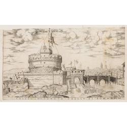
Castello Sancto Angelo di Roma.
The print features the Castello Sant' Angelo in Rome, bound in an album, perhaps from the "Speculum Romanae Magnificentiae." Copper engraving and published by A...
Date: Rome, Antonio Lafreri, ca. 1573

Franciae orientalis../ Monasteriensis et osnaburgensis..
From 'Theatrum Orbis Terrarum [Atlas of the Whole World]' published in Antwerp. French text on verso.The map of Frankenland is prepared by Sebastian Rotenhan (1478-1532) ...
Date: Antwerp, c.1574
![Naumaohiae [sic] id est navalis pugnae ex vetusteis lapidum et nummorum monumenteis graphica deformatio.](/uploads/cache/49142-250x250.jpg)
Naumaohiae [sic] id est navalis pugnae ex vetusteis lapidum et nummorum monumenteis graphica deformatio.
Naval engagement set inside an arena, spectators in the stands attending the event; reclining river god and nymphs in the lower part. From "Speculum Romanae Magnific...
Date: Rome, ca. 1575
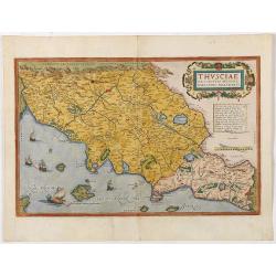
Thusciae Descriptio Auctore Hieronimo Bellarmato.
Decorative and detailed map of Tuscany, from the 1574 or 1575 Latin text edition of Ortelius' Theatrum Orbis Terrarum, the first modern atlas of the world. The map is bas...
Date: Antwerp, 1574-1575

Schlavoniae, Croatiae, Carniale.. Bosniae. . .
First state. Fine and early map of former Yugoslavia after a map of Hirschvogel (1552-1565) and used by A.Ortelius in his atlas 'Theatrum Orbis Terrarum [Atlas of the Who...
Date: Antwerp, 1579

Slusa, Teutonicae Flandriae opp. . . (Sluis)
Bird'eye view of the town of Sluis.From the greatest publication in this genre!. The Civitates was compiled and written by George Braun, Canon of Cologne Cathedral. Braun...
Date: Cologne, 1580
![Traiectum ad Mosam. [Maastricht]](/uploads/cache/47901-250x250.jpg)
Traiectum ad Mosam. [Maastricht]
A birds-eye view of Maastricht seen from the south. Rising on Vrijthof square is the dominant complex of Sint-Servaas, in front of which - seen here in a distorted perspe...
Date: Cologne, ca. 1581

Descrittione di M. Lodovico Guicciardini patritio Fiorentino, di tutti i Paesi Bassi,...
Second Italian edition (variant B) and first Plantin edition (1st Silvius 1567) and the most sought-after edition of the famous description of the Low Countries, updated ...
Date: Antwerp, Plantin, 1581

Tafel der Lender darin der Apostel Paulus geprediget hat.
Rare wood block map depicting the Mediterranean, with an over-sized Cyprus from the final Dutch edition of Heinrich Bünting's famous Itinerarium Sacrae Scripturae, a book...
Date: Magdeburg, 1581
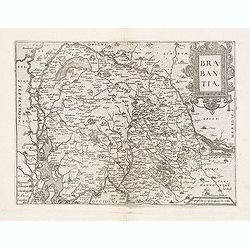
Brabantia.
Map of Brabant from Guicciardini's "Description de touts les Pais-Bais" edited by Plantin in 1582. The map drawn after Ortelius' map of Brabant, and after the l...
Date: Antwerp, 1582
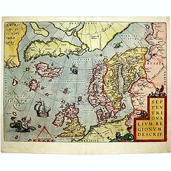
Septentrionalium Regionum Descrip.
1584 ORTELIUS, A. - Scandinavia, Iceland, Greenland and part of the North American continent, includes also the legendary islands of i.a. Drogeo, Frisland and Icaria.
Date: Antwerp, 1584

Universe Europae Maritime Eiusque Navigationis Descriptio. Generale Pascaerte van Europa . . .
This general chart of north-western Europe and the surrounding coastal waters is from the rare pilot-guide De Spiegel der Zeevaerdt , printed by Christopher Plantin in Le...
Date: Leyden, 1584
![Anverpia, nobile in Barbantia oppidum, parrim maritimum . . . [Antwerp]](/uploads/cache/26518-250x250.jpg)
Anverpia, nobile in Barbantia oppidum, parrim maritimum . . . [Antwerp]
The bird's-eye plan provides an excellent view of the citadel, city, docks and fortifications. The city was defended by a line of fortification and a moat constructed und...
Date: Cologne, 1585
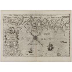
De Zee-Kuste vant Landt te Noort-oosten sorterende onder Norweghen ende eendeels onder Sweden alsoe tlandt aldaer in zijn gedaente is, van Distelberch tot Waersberghe.
A rare Latin text edition of this early and detailed chart of the coast of Norway of this landmark contribution to the science of navigation. Decorated by a large title c...
Date: Leiden, Plantijn, 1585

Zee caerte vande Sondt tvermaerste van Danemarcke . . .
A detailed chart of the coast of Denmark and its islands, Copenhagen in the center of the chart. West to the top. It is decorated by a title, scale and descriptive cartou...
Date: Leiden, Plantijn, 1585

De custen van een deel van Denemarken en Swede. . .
A detailed chart of the coast Skane and Kalmar, with the island Öland. Decorated by a title and scale cartouche, a compass rose, several vessels and sea monsters, and dep...
Date: Leiden, Plantijn, 1585

Caerte der Noordt cufte van Engelandt, beginnende van Robinhodes baij tot Coket Eijlandt. . . .
A very early Dutch text edition of this detailed chart of the northern coast of England. The mileage cartouche has no Latin captures. West to the top.Decorated by a color...
Date: Leiden, Plantijn, 1585

Belchrijuinghe vande zee custen van Engelandt. . .
A rare Dutch text edition of this detailed early chart of the northern coast of England. West to the top. The mileage cartouche has no Latin captures. Decorated by a colo...
Date: Leiden, Plantijn, 1585

De zee cuften tufschen Dovere en Orfords nesse, daer de Teemse de Vermaerde Rivire van Lonen gelegens is. . .
A detailed chart of the English Channel coastland. Decorated by a colorful title cartouche and scale cartouche, one compass rose, several vessels and sea monsters. A very...
Date: Leiden, Plantijn, 1585

Beschrijvinge vande de zee Cuften va Vlanderen en Picardien. . .
DUTCH TEXT EDITION. A detailed chart of the coast of Flanders and Normandy decorated by a large colorful baroque title cartouche, and the coat of arms of Flanders with a ...
Date: Leiden, Plantijn, 1585
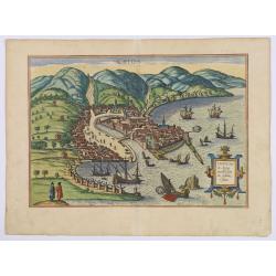
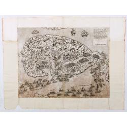
Chios.
The engraving shows the seaport of Chora, the capital of Chios, as seen from the east in a bird's-eye view.
Date: Cologne, ca 1588
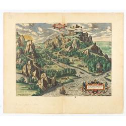
Tempe.
An attractive view of Mount Olympus and the valley in northern Thessaly (Greece), called the Vale of Tempe in ancient times, through which the river Peneus (present-day S...
Date: Antwerp, 1590

The hanging of the head of police Jean Grauwels in Brussels, 11 february 1569.
Print relating to Brussels during the first decades of the eighty year war between Spain and the Low Countries: (plate 18). This plate shows the hanging of the head of po...
Date: Cologne, ca. 1590

POLONIAE finitimarumque locorum descrip:tio. Auctore WENCESLAO GRODECCIO. Polono.
Ortelius' map of Poland, being a close copy of Grodecki / Pograbka's map of 1558/62 map, itself based on Wapovsky 1526 (Karrow 56) With Latin text on verso, a state 4 and...
Date: Antwerp, 1592
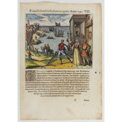
Prima Columbiin Indiam navigation Anno 1492.
Christopher Columbus and the Pinzon brothers leaving the port of Palos in Spain on August 3, 1492 for the New World. Right The King and Queen of Portugal Catholic Ferdina...
Date: Frankfurt, 1594

Lutetia Furens. Das ist : Die wütende Statt PARIS.
Rarissime placard dirigé contre la Ligue et le duc de Mayenne. La gravure est signée I.S. (marque inconnue). Ce placard en latin et en allemand est une reprise de l’estam...
Date: France ca.. 1594

Latium.
Based on classical authors' sources, specifically Virgilius, Plinius, Varro, Halicarnasseus, Festus and Ausonius.Philip Wingius in his letter to Ortelius from 1592 mentio...
Date: Antwerp, 1595

Peregrinationis Divi Pauli Typus corographicus. . .
A splendid map depicting the travels of Paulus. With two fine scenes in top. Showing the countries along the Mediterranean, including Cyprus and Italy. A first edition wi...
Date: Antwerp, 1595
Selling price: ????
Please login to see price!
Sold in 2026

Nova et recens emendata totius Regni Ungariae una cum adiacentibus et finitimis regionisbus delineatio.
Engraved map by Jan van Deutecum, here the very rare first edition published by Cornelis Nicola in Amsterdam in 1596. In very attractive original coloring.A re-issued was...
Date: Amsterdam, Cornelius Nicol, 1596

Metileme. (Lesbos)
Very rare map of Lesbos published in the first edition of "Viaggio da Venetia, a Costantinopoli. Per Mare, e per Terra, & infieme quello di Terra Santa. Da Giose...
Date: Venice, Giacomo Franco, 1598

Scio. (Chios)
Very rare view of Chios Island published in the first edition of "Viaggio da Venetia, a Costantinopoli. Per Mare, e per Terra, & infieme quello di Terra Santa. D...
Date: Venice, Giacomo Franco, 1598
![Stampalia. [Map of Astypalaia]](/uploads/cache/45244-250x250.jpg)
Stampalia. [Map of Astypalaia]
Very rare map of the Greek island Astypalaia. The island is known in Italian as Stampalia. Published in the first edition of "Viaggio da Venetia, a Costantinopoli. P...
Date: Venice, Giacomo Franco, 1598

Santorini.
Very rare map of Santorini published in the first edition of "Viaggio da Venetia, a Costantinopoli. Per Mare, e per Terra, & infieme quello di Terra Santa. Da Gi...
Date: Venice, Giacomo Franco, 1598
![Rodi [View of Rhodes]](/uploads/cache/45236-250x250.jpg)
Rodi [View of Rhodes]
Very rare view of the City of Rhodes on the island of Rhodes. Historically, Rhodes island was very famous worldwide for the Colossus of Rhodes, one of the Seven Wonders o...
Date: Venice, Giacomo Franco, 1598

Gelriae, Cliviae, Finitimorumque Locorum Verissima..
East to the top. Fine map of Geldria and Limburg, prepared by Christian s'Grooten. Very fine title cartouche lower right with painter's utensils around the cartouche. ...
Date: Antwerp, 1598

Hollandiae Antiquorum Catthorum..
This map shows Holland in great detail, including small towns, walled cities, rivers and lakes (many of which were reclaimed in the 17th century, and no longer exist). A ...
Date: Antwerp, 1598

Silesiae typus..
Fine and early map of Silesia after Martin Helwig (1516-1574) and used by A.Ortelius in his atlas 'Theatrum Orbis Terrarum [Atlas of the Whole World].Only included in the...
Date: Antwerp, 1598
![[ Map of the island Nexos]](/uploads/cache/45289-250x250.jpg)
[ Map of the island Nexos]
1598 - ROSACCIO, Giuseppe. - Very rare map of the island of Naxos published in the first edition of "Viaggio da Venetia, a Costantinopoli".
Date: Venice, Giacomo Franco, 1598
Selling price: ????
Please login to see price!
Sold in 2026
![[View of Gulf of Trieste].](/uploads/cache/45191-250x250.jpg)
[View of Gulf of Trieste].
Very rare view of Gulf of Trieste published in the first edition of "Viaggio da Venetia, a Costantinopoli. Per Mare, e per Terra, & infieme quello di Terra Santa...
Date: Venice, Giacomo Franco, 1598
![[Map of Corfu. View of the city of Corfu on the foreground. ]](/uploads/cache/45221-250x250.jpg)
[Map of Corfu. View of the city of Corfu on the foreground. ]
Very rare map of Corfu with a view of the city of Corfu on the foreground. Published in the first edition of "Viaggio da Venetia, a Costantinopoli. Per Mare, e per T...
Date: Venice, Giacomo Franco, 1598
