Browse Listings in Africa > North Africa > North Africa

.Tabu nova partis Aphri.
This is Laurent Fries' 1535 edition of the earliest acquirable modern mapping of Africa north of the Equator.Based on Waldseemüller's map. The maps show Northern Africa ...
$1800 / ≈ €1572
Date: Lyons, M. Servetus, 1535
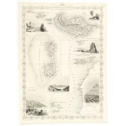
Islands in the Atlantic.
Decorative steel engraved map of Islands showing the Azores, Madeira, Bermuda, the Canaries and the Cape Verdes. Interlocking border design. Taken from "The illustra...
$150 / ≈ €131
Date: London, ca. 1851

Manoeuvres executées du 7 au 13 mai sous le Commandement du général Koeltz,par le XIXe Corps d'Armée. . .
Poster by Gaston Ry [aka René Rostagny] (1902-1978) showing the allied manouvers in Tunesia. On May 4, 1943, the nineteenth CA offensive drew most of the German tanks to...
$750 / ≈ €655
Date: Alger, Bacconnier, 1943
