Wish List
With WishList / Virtual Collection, you can save and collect your favorite items in one place, it is free and you can delete an item from your list at any time.
Save any of the 30.000+ maps, prints or Medieval manuscripts from our BuyNow Catalog or Catalog Archive.
Unless logged in, an item is only saved for that session. If you want to save the items permanently, please log in first.
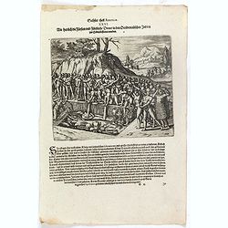
Wie herrlich die Fürsten und Fürstliche Diener in den Occidentalischen Indien zur Erden bestattet werden.
Native Americans bury a chief or king with food, golden vessels, and jewelry. Includes feathered garments and fortifications. The funeral of an Inca king was a ceremony o...
Place & Date: Frankfurt, 1607
Selling price: $60
Sold in 2023
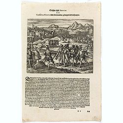
Das sechste Theil der nieuwen Welt oder Der Historien Hieron. Benzo von Meylandt. . .
Conflict between Gonzalo Pizarro and the latest officially appointed governor of Peru, Pedro de la Gasca, reached a climax in 1548 when Gasca’s forces crossed the Apuri...
Place & Date: Frankfurt, 1607
Selling price: $60
Sold in 2023
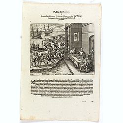
Franciscus Pizarrus, Didocus Almagrus, und ein Priester Ferdinandus Luques machen eine Verbündnuss zusammen.
Francisco Pizarro, Diego de Almagro, and the priest, Hernando de Luque, negotiate a contract while men load cargo onto boats and ships. Includes dwellings, casks, swords,...
Place & Date: Frankfurt, 1607
Selling price: $50
Sold in 2023
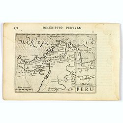
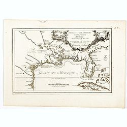
Peru.
An attractive miniature map of Peru, with north orientated to the right, published by Petrus Bertius in Amsterdam at the turn of the seventeenth century. Some interior i...
Place & Date: Amsterdam, 1606
Selling price: $80
Sold in 2023
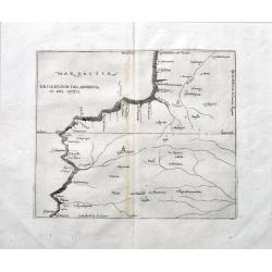
Descripcion del audencia 10 del Quito.
A rare early map with parts of modern day Ecuador, Columbia and Peru. Naming towns, and showing rivers. The earliest map to include information from the previously secret...
Place & Date: Madrid, ca 1601
Selling price: $200
Sold in 2022
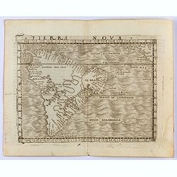
Tierra Nova
Gastaldi's map of South America from Giacomo Gastaldi's Atlas of 1548 which has been called the most comprehensive atlas, produced between Martin Waldseemüller's Geograp...
Place & Date: Venice, 1548
Selling price: $700
Sold in 2022

Plan de la rade de Macao (chine) Levé d'après les ordres mr. Rocquemaurel.
Very detailed chart of Macao and several of the surrounding Islands, and features numerous depth soundings throughout. Prepared by captain, Gaston de Rocquemaurel. Logo o...
Place & Date: Paris, c.1856 / 1863
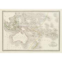
Carte de l'Océanie.
Steel engraving of Australia, New Zealand and Indonesia. Engraved by Thierry.Published by Conrad Malte-Brun (1775-1826). Mapping of Australia [+]
Place & Date: Paris, c.1835
Selling price: $100
Sold in 2023
![[A village scene from the Sandwich Islands ].](/uploads/cache/26371-250x250.jpg)
[A village scene from the Sandwich Islands ].
Aquatint depicting a village scene from the Sandwich Islands engraved by Castelli. Plate N° 92.The Sandwich Islands was the name given to the Hawaiian Islands by Captain...
Place & Date: Milan, 1827
Selling price: $45
Sold in 2022
![[Sandwich Island's rituals edifice ].](/uploads/cache/26262-250x250.jpg)
[Sandwich Island's rituals edifice ].
Aquatint depicting Sandwich Island's rituals edifice. The Sandwich Islands was the name given to the Hawaiian Islands by Captain James Cook on his discovery of the island...
Place & Date: Milan, 1827
Selling price: $50
Sold in 2021
![[Captain Cook's arrival - Hawaii ].](/uploads/cache/26259-250x250.jpg)
[Captain Cook's arrival - Hawaii ].
Aquatint depicting a group of Hawaiian people honoring and welcoming Captain Cook's arrival in front of a sacred edifice.The Sandwich Islands was the name given to the Ha...
Place & Date: Milan, 1827
Selling price: $60
Sold in 2022
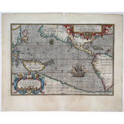
Maris Pacifici, (quod vulgo Mar del Zur) ...
The first printed map of the Pacific Ocean. Date on the map: 1589, first published 1590. Based on Mercator's world map of 1569. This was the first map to focus on the Pac...
Place & Date: Antwerp, 1589 / 1603
Selling price: $4600
Sold in 2022
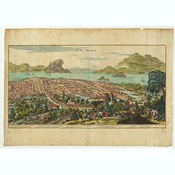
Nova Mexico.
This sweeping panorama of a walled Mexico City was the first published view to identify Tenochtitlan as Mexico City. This is one of the most important views of the great ...
Place & Date: London, ca 1671
Selling price: $210
Sold in 2022
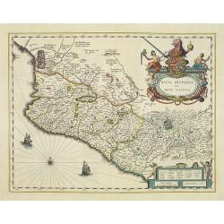
Nova Hispania et Nova Galicia.
Based on Ortelius' map of 1579 which became the basis for many of the seventeenth century maps of the area. A splendid and colored title cartouche with two allegorical fi...
Place & Date: Amsterdam, 1635
Selling price: $350
Sold in 2022
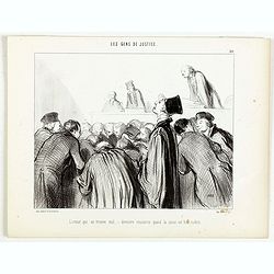
Les Gens de Justice. - L'avocat qui se trouve mal - dernière ressource quand la cause est bien malade.
Second state (of 2), with text. From "Les Gens de Justice". Text below image : - L'avocat qui se trouve mal - dernière ressource quand la cause est bien malade...
Place & Date: Paris, 1845-1848

Chart of the World on Mercator's Projection
A small inexpensive late 18th century map of the world by Benjamin Baker. 'New Holland' is still incorrectly shown with Tasmania joined to the mainland, New Guinea's coas...
Place & Date: London, 1796
Selling price: $17
Sold in 2021
Clog Almanac.
An interesting engraving of a Clog Almanac published in Camden's Brittania, and engraved by John Cary.The clog almanac is a primitive kind of almanac or calendar, formerl...
Place & Date: London, 1806
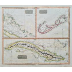
Charte of the Bahama Islands / The Bermuds or Summer Islands / Island of Cuba
Three maps on one large sheet. Detailed maps of the Bahamas, Bermuda, and Cuba. Large scale with many place names, including small islands, towns, and roads.
Place & Date: London, 1817
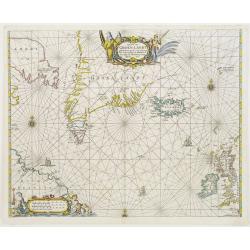
Pascaerte van Groen-Landt, Yslandt, Straet Davids en Ian Mayen eylandt..
An eye-catching chart of the North Atlantic, showing prominent Greenland, Iceland and parts of the North American continent. The map is decorated with a large figurative ...
Place & Date: Amsterdam 1666
![[Lot of 10 maps /views of the Caribbeans], Terre Ferme, Isles Antilles et N.lle Espagne.](/uploads/cache/18346-(1)-250x250.jpg)
[Lot of 10 maps /views of the Caribbeans], Terre Ferme, Isles Antilles et N.lle Espagne.
Louis Brion de la Tour (1756-1823), ' Atlas Géneral, Civil et Ecclésiastique', 1766, ' Atlas Général', 1790-98. Louis Charles Desnos (fl.1750-70), Le Rouge's 'Atlas...
Place & Date: Paris, c. 1760
Selling price: $200
Sold in 2022
Carta particolare del'mare del Zur che comincia con il capo S. Francesco nel Peru e finisce con il capo S. Lazaro nella nuova Spagnia.
FIRST EDITION Dudley’s magnificent chart of the Pacific Coast of Central and South America, from the coast of Columbia and Ecuador in the north to the Bay of Honduras i...
Place & Date: Florence 1661
Selling price: $2250
Sold in 2023
![[ Lot of 3 maps] Terra Firma et Novum Regnum.](/uploads/cache/19390-(1)-250x250.jpg)
[ Lot of 3 maps] Terra Firma et Novum Regnum.
Willem Blaeu’s map of Columbia with the Isthmus of Panama. Embellished with two cartouches and two compass-roses. Willem Blaeu, the father of Johan and Cornelis Blaeu, ...
Place & Date: Amsterdam, 1655
Selling price: $125
Sold in 2022

Planta topografica della R.Citta di Venezia con XIX de suoi principali prospetti.
Precise, beautiful bird's-eye view of Venice, clearly depicting the city's architectural landmark. The map is surrounded by 19 detailed views of important places in town....
Place & Date: Milan 1820
![[Lot of 7 maps and gravure] Nova Hispania et Nova Galicia. [with map of Guatamala]](/uploads/cache/IMG_2235-250x250.jpg)
[Lot of 7 maps and gravure] Nova Hispania et Nova Galicia. [with map of Guatamala]
Willem Blaeu’s beautiful map of Mexico is decorated with a very large title-cartouche with the coat-of-arms of the king of Spain, another cartouche and two ships and a ...
Place & Date: Amsterdam, ca 1636
Selling price: $240
Sold in 2023
![[lot of 8 maps/ prints of the Caribbean] Cuba Insula, inset: Havanna portus; Hispanolia Insula; Insula Iamaica; Ins. S. Ioannis; I.s. Margareta.](/uploads/cache/20279-(4)-250x250.jpg)
[lot of 8 maps/ prints of the Caribbean] Cuba Insula, inset: Havanna portus; Hispanolia Insula; Insula Iamaica; Ins. S. Ioannis; I.s. Margareta.
Re-issue of Gerard Mercator's small atlasA lot of 8 maps and prints of the Caribbean.
Place & Date: Amsterdam, 1630-1636
Selling price: $120
Sold in 2022
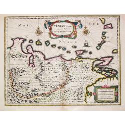
Venezuela, cum parte Australi Novae Andalusiae.
Venezuela, cum parte Australi Novae Andalusiae. A very fine example of Willem Blaeu's map of Venezuela and Columbia, embellished with two cartouches, two compass-roses...
Place & Date: Amsterdam, c. 1635
Selling price: $180
Sold in 2023
-250x250.jpg)
Hispaniolae, Cubae Alliarumique Insularium
Abraham Ortelius (1527-98), Dutch cartographer and publisher of the first modern atlas, ' Theatrum Orbis Terrarum' in 1570. Editions till 1612. Also an atlas of ancient c...
Place & Date: Antwerp, 1609
Selling price: $250
Sold in 2022
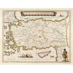
Natolia, quae olim Asia minor.
A finely designed map of Turkey and Cyprus from the great Blaeu family of Amsterdam. The decoration consist of a colored title cartouche, sea monsters, a naval engagement...
Place & Date: Amsterdam, 1635
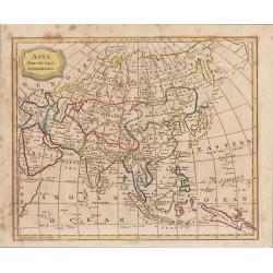
“Asia, from the Best Authorities”
An attractive small map of Asia engraved by James Barlow with original hand coloring. Published by C. Brightly and J Kinnersley, in Bungay Suffolk, November 1st, 1806.
Place & Date: Bungay, 1806

Rowntree's Elect Cocoa.
Chromo lithographed poster of Les Maîtres de l'Affiche being plate n°168. The "Les Maîtres de l'Affiche" contained 256 small for lithographic prints of the b...
Place & Date: Paris, Imprimerie Chaix, 1899
![[Original Chinese advertising poster for Gande, Price & Co., Ltd. Hong Kong]](/uploads/cache/45059-250x250.jpg)
[Original Chinese advertising poster for Gande, Price & Co., Ltd. Hong Kong]
Original vintage Chinese poster for "GANDE, PRICE & CO. LTD., based in Hong Kong, promoting Haig Whisky (from Scotland), Moet & Chandon, Taylor’s London Dr...
Place & Date: Shanghai, 1934
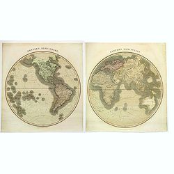
Eastern Hemisphere / Western Hemisphere.
A nice pair of maps of the twin hemispheres, taken from John Thomson's. A New General Atlas, (Edinburgh), first published in 1814.When assembled this large pair of maps m...
Place & Date: Edinburgh, 1815
Selling price: $200
Sold in 2021
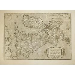
ANGLIAE, SCOTIAE ET HIBERNIAE, SIVE BRITANNICAR: INSVLARVM DESCRIPTIO.
A beautiful map of the British Isles, north to the right. The map is based on Mercator's earlier map of the British Isles of 1564. Title in strapwork cartouche at top rig...
Place & Date: Antwerp, 1592
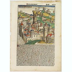
Tercia Etas Mundi. Folium.XLVI (A English town view)
Large woodcut depicting an imaginary English town (235x223mm.) and on verso the genealogy of King David.Page from the richest illustrated Incunable, the famous: Chronicle...
Place & Date: Nuremberg, 12 July 1493
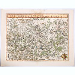
Lotharingia Ducatus vulgo Lorraine.
A very detailed map for his time centered on Nancy, Bayon and Metz, and including the river valleys of the Sar and Moselle. In the lower right-hand corner of the map is a...
Place & Date: Amsterdam, ca 1640
Selling price: $16
Sold in 2021
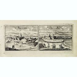
Rechnitz / Lewentz. (Breznica and Levice)
Magnificent bird's eye- of Breznica and Levice in Slovenia. Etched by Gaspar Bouttats (1640-1695).The Antwerp based publisher Jacques Peeters published ca. 1690 a series ...
- $150 / ≈ €131
Place & Date: Antwerp, c.1690

Pascaerte van 't Westelyckste Deel van Oost Indien, van Cabo de Bona Esperanca tot C.Comorin..
An eye-catching chart of the western part of the Indian Ocean and its adjacent coasts of East Africa, Arabia with the Red Sea and the Arabian Gulf, Iran, Pakistan and we...
Place & Date: Amsterdam, 1666
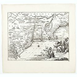
Hurons.
A charming depiction of Hurons or Wynadot / Wendat tribe with bow hunting and cooking. Title in curtain draped at top. French text on verso.From the original 1683 text ed...
Place & Date: Paris, 1683
Selling price: $40
Sold in 2022
![Kaert van Groen-Land [Map of Greenland]](/uploads/cache/48503-250x250.jpg)
Kaert van Groen-Land [Map of Greenland]
A very rare map of the Northern Atlantic Ocean, showing the North American coast, Greenland, Scotland and the coast of Norway. In the Atlantic are Iceland and the mythica...
Place & Date: Nuremberg or Netherlands, after 1679
Selling price: $650
Sold in 2023
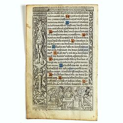
Leaf on vellum from a printed Book of Hours.
21 lines of printed text, surrounded by Renaissance borders decorated with flowers and little miniatures with figures on both sides.From the press of the leading Parisian...
Place & Date: Paris, Germain Hardouyn, c. 1520-1540

Carte de la Californie et des Pays Nord-Ouest..
From Diderot's Encyclopedia. Fascinating study of the comparative cartography of the West Coast of North America, from the Straits of Anian to Cabo San Lucas and the sout...
- $150 / ≈ €131
Place & Date: Paris, 1772
![Apothicaar Orquest [Apothecary Orchestra]](/uploads/cache/46536-250x250.jpg)
Apothicaar Orquest [Apothecary Orchestra]
A delicate and humorous watercolor of a set of musicians assembled using clysters and other 'items' as musical instruments.
Place & Date: Netherlands, ca 1818
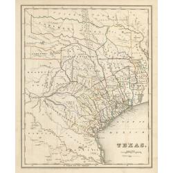
Texas
This is an important map of Texas during its time as a republic, showing the region as divided into land grants based on empresarios established by the Mexican government...
Place & Date: Boston, 1841
Selling price: $1200
Sold in 2023
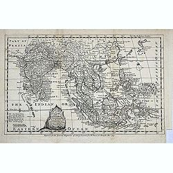
An Accurate Map of the East Indies exhibiting the course of the European trade both on the Continent and Islands..
Detailed map of South East Asia including the Philippines, Indonesia and northern tip of Australia. Fine title cartouche. Engraved for the "General Magazine of Arts ...
Place & Date: London, 1767
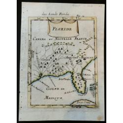
Floride
Rare 17the century copper engraved map of Florida from Allain Manesson Mallet's Description De L' Univers, Contenant Les Differents Systemes Du Monde, Les Cartes generale...
Place & Date: Paris, 1683
Selling price: $140
Sold in 2023

(Postcard of Europe)
During the Great War, when the only means of communicating news to the masses was by newspapers and weekly illustrated magazines, the ‘war’ or 'military' picture post...
Place & Date: Moscow, 1914
Selling price: $110
Sold in 2025
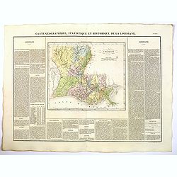
Carte Geographique, Statistique et Historique de Louisiane.
A nice detailed map of the state of Louisiana from Buchon's Atlas Gégraphique Statistique, historique et chronologique des deux Ameriques et des isles adjacentes traduit...
Place & Date: Paris, 1825
Selling price: $100
Sold in 2022
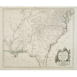
Partie Méridionale de la Louisiane, avec la Floride, la Caroline et la Virginie..
Fine map of southeastern part of the United States after d'Anville's, to whom Santini gives credit in the cartouche.It covers the Atlantic coastline between the Chesapeak...
Place & Date: Venice, 1776 - 1784
Selling price: $1500
Sold in 2008
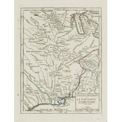
Cours du Mississipi et la Louisiane.
Nice small map showing the course of the Mississippi River, from Minnesota to the Gulf of Mexico.Number 92 outside border top right. Mary Sponberg Pedley does not mention...
Place & Date: Paris, later than 1749
Selling price: $95
Sold in 2022
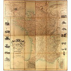
Carte routière de France de Dion Bouton spéciale pour automobiles
Highly decorative folding wall map of France in a scale of 1 : 800 000. In the upper left hand corner an inset plan of Paris, upper right Algeria and lower right map of C...
- $1500 / ≈ €1314
Place & Date: Paris, J. Barreau, 1900
Les Costes aux Environs de la Riviere de Misisipi.
An historically important map of Florida and the Gulf Coast showing especially the estuary of the Mississippi in some detail, more or less correctly located.The locations...
Place & Date: Paris, 1701
Selling price: $700
Sold in 2022
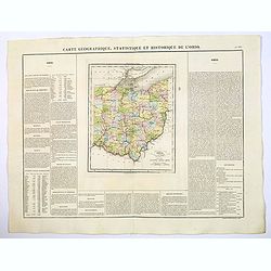
Carte Geographique, Statistique et Historique de L'Ohio.
A nice detailed map of the state of Ohio from Buchon's Atlas Gégraphique Statistique, historique et chronologique des deux Ameriques et des isles adjacentes traduit de l...
Place & Date: Paris, 1825
Selling price: $50
Sold in 2022
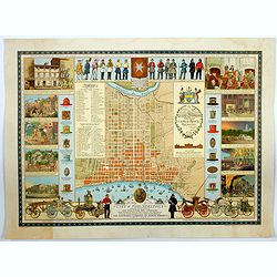
A Map of the City of Philadelphia, showing the Location of the Volunteer Fire Companies. . .
A fine, large pictorial plan of the City of Philadelphia, based on the drawing by Jacob Riegel in 1937, which itself was based on an earlier work dating back to 1794. The...
Place & Date: Philadelphia, 1938
Selling price: $200
Sold in 2021
![[City Of New York and Environs].](/uploads/cache/27530-250x250.jpg)
[City Of New York and Environs].
A very decorative bird's-eye view of Manhattan, Brooklyn, and part of New Jersey. Manhattan Island from the southwest is surrounded by the Hudson, Harlem, East River, and...
Place & Date: New York, 1875
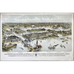
Grand Birds-Eye View of the Grounds and Buildings of the Great Columbian Exposition at Chicago, Illinois, 1892-3.
Lithography after a watercolor by C. Graham created as part of a portfolio for the World's Columbian Exposition (also known as the Chicago World's Fair) was a world's fai...
Place & Date: New York, 1892
Selling price: $1200
Sold in 2023
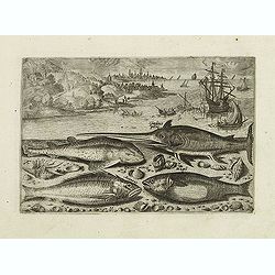
Gladius piscis, Galeus piscis, Araneus, Mugil. (Piscium Vivæ Icones - Fish)
Depiction of Gladius piscis, Galeus piscis, Araneus, Mugil. Fish set against a mountainous landscape in the manner of Pieter Brueghel the Elder. Plate number 15. The engr...
Place & Date: Antwerp, after 1598
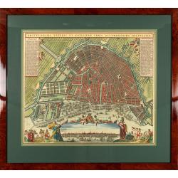
Amstelodami veteris et novissimae urbis accuratissima deline
A decorative plan of the town with at left and right legends mentioning the most important buildings and streets. At bottom center a view of the town from 't IJ. From Atl...
Place & Date: Amsterdam, 1745-1754
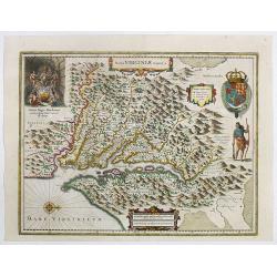
Nova Virginiae Tabula.
One of the most important maps of the Chesapeake Bay region, credited with disseminating knowledge of the English settlement in Virginia throughout Europe in the 17th cen...
Place & Date: Amsterdam, ca. 1636
Selling price: $1200
Sold in 2022
Recens Edita totius Belgii, in America
Arguably one of the most recognizable maps of the Northeastern American colonies this fifth state example of Novi Belgii by Tobias Conrad Lotter series does not disappoin...
Place & Date: Augsburg, Germany 1757
Selling price: $2300
Sold in 2023
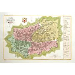
Pianta della citta di Lucca.
Very finely engraved and detailed plan of Lucca. Coat of arms of the town on the upper part. Engraved by V.Angeli and included in: Atlante Geografico dell Italia .To the ...
Place & Date: Rome, 1860
Selling price: $210
Sold in 2025
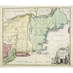
Nova Anglia Septentrionali Americae implantata . . .
German interest in North America was high during the first half of the eighteenth century when Johann Baptiste Homann was the leading German cartographer. During this per...
Place & Date: Nurnberg, 1720
Selling price: $1050
Sold in 2022
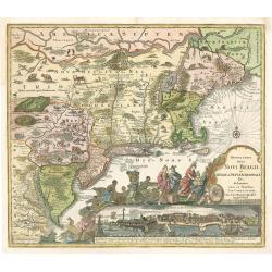
Novi Belgii, quod nunc Novi Jorck vocatur, Novaeque Angliae & Partis Virginiae Accuratissima et Novissima Delineatio.
A beautifully engraved map of the Northeast, extending from the St. Laurence and New England to the Chesapeake and centered on Long Island, which is still shown as an isl...
Place & Date: Amsterdam, 1673
Selling price: $1000
Sold in 2022
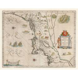
Nova Belgica Et Anglia Nova
An important and early colonial era map of the Dutch and English colonies of northeast America by the renowned 17th century map maker, Willem Janszoon Blaeu. The map is d...
Place & Date: Amsterdam, 1640
Selling price: $1600
Sold in 2023

CRAWFORD YOUNG - SIR, DON'T WASTE WHILE YOUR WIFE SAVES. Circa 1918.
A World War I conservation poster encouraging indulgent Americans to rein in their appetites during war time. Printed by W. F. Powers Litho Co., New York.
Place & Date: Washington DC, 1918
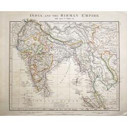
India and the Birman Empire with part of China &c.
A clean example of Aaron Arrowsmith's 1828 map of India. A highly detailed map of Asia. The regional boundaries are colored and relief shown by hachures. This map was pub...
Place & Date: London, 1828

(A set of nine plates about the making of Marly Gauze) Metier a Faire du Marli.
A set of nine plates ‘Metier a Faire du Marli’ (The Making of Marly Gauze), from, Diderot's ‘Encyclopede du Duictionarnaire Raisonn des Sciences’. dited by Denis ...
Place & Date: Paris, 1751
![Tabula Californiae, Anno 1702 … Ex autoptica observatione delineata a R.P. Chino e S.I. [The Map of California in 1702 as Observed and Drawn by Father Chino, S. J.]](/uploads/cache/85891-250x250.jpg)
Tabula Californiae, Anno 1702 … Ex autoptica observatione delineata a R.P. Chino e S.I. [The Map of California in 1702 as Observed and Drawn by Father Chino, S. J.]
The much sought after so-called KINO-map of California as a peninsula, a result of Father Kino's travels which misspelled the island-phantasy. This his second map is...
Place & Date: Augsburg & Graetz, 1726
Selling price: $600
Sold in 2021
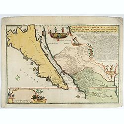
La Californie ou Nouvelle Caroline.
This fine rare map is a reissue of de Fer's map of 1705 but on a larger scale, and with some notable additions. A boldly engraved and handsome item, the largest scale map...
Place & Date: Paris, 1720
Selling price: $5600
Sold in 2022

Delineatio Alicuyus Spatii Petersburgi in Russia..
Print of a street in Petersburg in Russia.Probst was a well-known publisher of optical prints, established in Augsburg.In the eighteenth and nineteenth centuries there we...
Place & Date: Italy, ca. 1760
Belgium sive Inferior Germania post omnes..
Early map of the Low Countries, engraved by Abraham Goos and published for the first time in 1618. In the top border town-views of Amsterdam, Dordrecht, Antwerp, Brussels...
Place & Date: Amsterdam, 1618/1631
![Province de Fo-Kien. [Includes West Coast of Taiwan]](/uploads/cache/43503-250x250.jpg)
Province de Fo-Kien. [Includes West Coast of Taiwan]
An important map of Fujian Province shows the East Coast of China and the West Coast of Taiwan. It shows that for the Manchu Qing, only the western half of Formosa was co...
Place & Date: The Hague, H. Scheurleer, 1737
![Carricta meridionalis, [vulgo], The South part of Carrick / auct. Timoth. Pont.](/uploads/cache/42489-250x250.jpg)
Carricta meridionalis, [vulgo], The South part of Carrick / auct. Timoth. Pont.
Very detailed map and striking map of the south part of Carrick in Scotland. Rare from Joan Blaeu's Atlas Major.Prepared by Timothy Pont and Robert Gordon. The map is enh...
Place & Date: Amsterdam, 1662
Selling price: $30
Sold in 2020
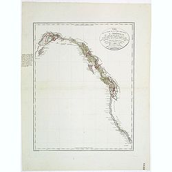
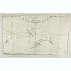
Carte de la partie de la cote nord-ouest de l'Amerique. Reconnue pendant les Etes de 1792, 1793 et 1794 depuis 29054' de latitude nord et 244033' de. . .
Detailed and rare map of the Gulf of Alaska, British Columbia, south to St.Francisco.Prepared by Edward Roberts after information by George Vancouver. Engraved by Tardieu...
Place & Date: Paris, 1820
Selling price: $150
Sold in 2011
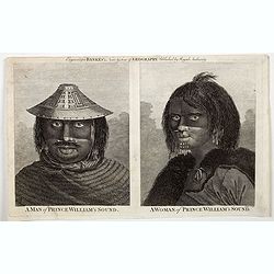
A Man of Prince William's Sound / A Woman of Prince William's Sound.
A pair of copperplate engravings of a man and a woman from Prince William's Sound in Gulf of Alaska - taken rom drawings by John Webber from John Hawkesworth's account of...
Place & Date: London, ca 1790
Selling price: $5
Sold in 2023
Carte de la Cote N.O. de l'Amerique et de la Cote N.E. de l'Asie, Reconnues en 1778 et 1779. Les parties de la Cote d'Asie qui ne sont pas ombrees sont tirees d'une Carte Manuscrite que nous donnerent les Russes.
Map of the North Pacific and contiguous coastlines of Alaska and Russia, published in the first French edition of the official account of James Cook's Third Voyage. The ...
Place & Date: Paris, 1785
Selling price: $275
Sold in 2022
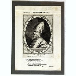
Theodorus Iohannis Basilidis Filius Moscoviae Magnus Dux / Atrium Heroicum.
Lettered with title around oval and two lines of Latin in lower margin: 'Mitior hic rexit ... / ... fato, de stirpe suprémus'. Lettered in letterpress above the platemar...
- $50 / ≈ €44
Place & Date: Augsburg, 1601-1604

La Chine.
Rare map of China, Korea (as an island) and Japan, published by Jollain in 1667. In upper right corner part of North America. Published in "Trésor Des Cartes Geogra...
- $350 / ≈ €307
Place & Date: Paris, 1667

Carta particolare che comincia con il c.apo Aldea è Finisce con il capo Degortam. . .
Dudley’s magnificent chart shows the south west coast of Africa with the Tropic of Capricorn, located at about 23.5 degrees south. A first edition without the privilege...
Place & Date: Florence, 1645

Over deese grietenije.. Eerste van Wester Goo..
Very decorative map centered on Menaam, Marsum and Boxum from the Uitbeelding der Heerlijkheit Friesland prepared by Schotanus. With ornamental title cartouche lower righ...
Place & Date: Leeuwarden, F.Halma, 1718

Feast of China.
A scene of a Chinese dinner feast from Linschoten's famous voyages to the East of 1583-92 here published by De Bry the year after they first appeared as a separate book. ...
Place & Date: Frankfurt, 1599