Subscribe to be notified if similar examples become available.
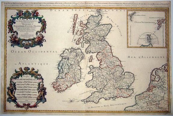
Les Isles Britanniques ou sont les Royaumes d' Angleterre, Ecosse, et Irlande; distingués en leurs principales Provinces. . . |
||||||||||||||||||||
|
||||||||||||||||||||
|
|
||||||||||||||||||||
Estimated value: $600 - $860 |
||||||||||||||||||||
Description
During the course of this map's life Jaillot had three pairs of plates engraved, with only minor changes. This is the second state of the first plate. The change of the date from '74' to '81' that is easily recognizable. Joined to the lot is the related engraved index sheet.
A very decorative map, with fine baroque title and scale cartouches and an inset of the Orkneys and Shetland Isles. Portions of France, Belgium, and the Netherlands are included to the east, separated from England by the Pas de Calais.
The Western Isles and the Orkneys are off the coast of Scotland, while the Scilly Islands are just west of Cornwall. In the upper right corner is an inset of the Upper Orkneys with the Faroes and Shetlands northwest and northeast respectively.
The British Isles are divided into nations and counties, with towns, cities, and rivers highlighted. Hadrian’s Wall is prominently shown. The wall was built by the Romans in 122 AD to protect their settlements in the south. London and Westminster are marked as close, yet separate cities. The western portion of the map is filled with decorative elements.
In the upper left is an elaborate floral motif flanked by rearing horses. Poseidon is sunning himself in a frame at the base. In the lower-left corner is an impressive scale bar characteristic of Jaillot.
Shirley says:: "one of the most attractive maps of the late 17th century".
Alexis-Hubert Jaillot (1632-1712) was one of the most important French cartographers of the seventeenth century. Jaillot traveled to Paris with his brother, Simon, in 1657, hoping to take advantage of Louis XIV's call to the artists and scientists of France to settle and work in Paris. Originally a sculptor, he married the daughter of Nicholas Berey, Jeanne Berey, in 1664, and went into partnership with Nicholas Sanson's sons.
Beginning in 1669, he re-engraved and often enlarged many of Sanson's maps, filling in the gap left by the destruction of the Blaeu's printing establishment in 1672.
Reference: SHIRLEY: British Isles 1650-1750, Jaillot 1,
FAQ - Guarantee - Shipping
Buying in the BuyNow Gallery
This item is available for immediate purchase when a "Add to Cart" or "Inquire Now" button is shown.
Items are sold in the EU margin scheme
Payments are accepted in Euros or US Dollars.
Authenticity Guarantee
 We provide professional descriptions, condition report and HiBCoR rating (based on 45 years experience in the map business)
We fully guarantee the authenticity of items we sell. We provide a certificate of authenticity for each purchased item.
Condition / Coloring
We indicate the condition of each item and use our unnique HiBCoR grading system in which four key items determine a map's value: Historical Importance, Beauty, Condition/Coloring and Rarity.
We offer many maps in their original black and white condition. We do not systematically color-up maps to make them more sellable to the general public or buyer.
Copper engraved or wood block maps are always hand colored. Maps were initially colored for aesthetic reasons and to improve readability. Nowadays, it is becoming a challenge to find maps in their original colors and are therefor more valuable.
We use the following color keys in our catalog:
Original colors; mean that the colors have been applied around the time the map was issued.
Colored; If the colors are applied recently or at the end of the 20th century, then "colored", or "attractive colors" will be used.
Original o/l colors; means the map has only the borders colored at the time of publication.
Read more about coloring of maps [+]
FAQ
Please have a look for more information about buying in the BuyNow gallery.
Many answers are likely to find in the general help section.
Virtual Collection
![]()
With Virtual Collection you can collect all your favorite items in one place. It is free, and anyone can create his or her Virtual map collection.
Unless you are logged in, the item is only saved for this session. You have to be registed and logged-in if you want to save this item permanently to your Virtual Collection.
Read More [+]
Registering Here, it is and you do not need a credit card.
Add this item to
Virtual Collection
or click the following link to see my Virtual Collection.
Invoice
The invoice and certificates of authenticity are available in the client center >Invoices
| High-Resolution Digital Image Download | |
|
Paulus Swaen maintains an archive of most of our high-resolution rare maps, prints, posters and medieval manuscript scans. We make them freely available for download and study. Read more about free image download |
Click this image for a free HR-image download. |
In accordance with the EU Consumer Rights Directive and habitually reside in the European Union you have the right to cancel the contract for the purchase of a lot, without giving any reason.
The cancellation period will expire 14 calendar days from the day after the date on which you or a third party (other than the carrier and indicated by you) acquires, physical possession of the lot. To exercise the right to cancel you must inform Paulus Swaen Inc, of your decision to cancel this contract by a clear statement (e.g. a letter sent by post, or e-mail (amsterdam@swaen.com).
To meet the cancellation deadline, it is sufficient for you to send your communication concerning your exercise of the right to cancel before the cancellation period has expired.