Subscribe to be notified if similar examples become available.
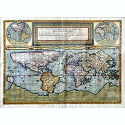
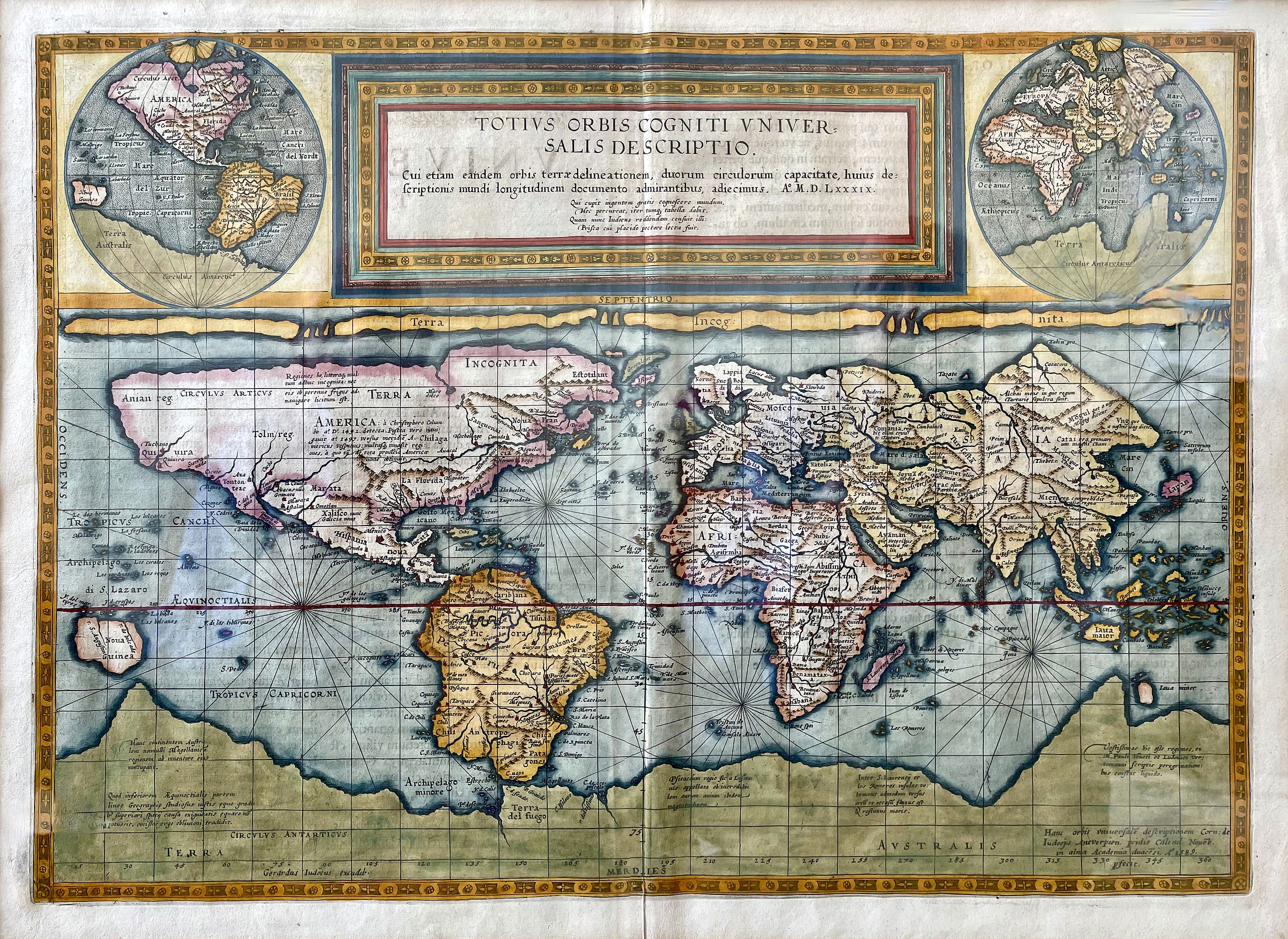
Totius Orbis Cogniti Universalis Descriptio. |
||||||||||||||||||||
|
||||||||||||||||||||
|
|
||||||||||||||||||||
Description
According to Rodney Shirley, the map is generally attributed to Marinus of Tyre, with geography based on Mercator and Ortelius, while in the top corners are two smaller maps showing the eastern and western
hemispheres on Roger Bacon’s circular projection.
Scarce. The map was engraved by the younger De Jode, Cornelis, in 1589 yet was not published in atlas form until 1593 after the elder De Jode’s death.There is a note in the lower right-hand corner stating that Corn: de
Iudoejs of Antwerp made the map in November 1589 at the Academy of Douai and the printer’s signature is that of Cornelis’ father, Gerard de Jode. Still, the map was not published until two years after his
father’s death. The map includes two hemispherical projections in the upper left and right-hand corners. The Southern Hemisphere is dominated by a vast Terra Australis Incognita, which includes Tierra del Fuego. South America appears in the “potato” form made familiar by Mercator and Ortelius.
North America, delineated much in the same tradition, is heavily speculative: the fictional regions of Anian and Norumbega appear prominently. Legendary cities of wealth such as “Quivira” and “Cevola” (both of which Coronado sought) are also on the map.
Although this map appears to have been plotted on the Mercator Projection, which was introduced in 1569, this is not the case. While a Mercator projection increases latitude near the poles to correct for the Earth’s curvature, lines of latitude remain constant. This projection has been attributed to Marinus of Tyre, a predecessor of Claudius Ptolemy, who developed the idea of meridians and parallels.
Speculum Orbis TerraeOnly one atlas was published by the de Jode family: Speculum Orbis Terrarum issued by Gerard de Jode in 1578, and then re-issued by his son Cornelis in 1593 as Speculum Orbis Terrae. The atlas was not a financial success and no other editions were published. Consequently, all maps by de Jode are quite rare.Three separate world maps were engraved for the Speculum, each issued only once. The 1578 edition featured a heart-shaped world map by Gerard and the 1593 edition included this map on a rectangular projection by Cornelis, along with a second unsigned double-hemisphere map.
Please Note : The map has been photographed behind glass and some reflection is therefore visible in the image.
Reference: Shirley, World, 165.
Reference: Shirley, World, 165.
FAQ - Guarantee - Shipping
Buying in the BuyNow Gallery
This item is available for immediate purchase when a "Add to Cart" or "Inquire Now" button is shown.
Payments are accepted in Euros or US Dollars. We accept most major credit cards, PayPal and bank transfer.
Authenticity Guarantee
 We provide professional descriptions, condition report and HiBCoR rating (based on 45 years experience in the map business)
We fully guarantee the authenticity of items we sell. We provide a certificate of authenticity for each purchased item.
Condition / Coloring
We indicate the condition of each item and use our unnique HiBCoR grading system in which four key items determine a map's value: Historical Importance, Beauty, Condition/Coloring and Rarity.
We offer many maps in their original black and white condition. We do not systematically color-up maps to make them more sellable to the general public or buyer.
Copper engraved or wood block maps are always hand colored. Maps were initially colored for aesthetic reasons and to improve readability. Nowadays, it is becoming a challenge to find maps in their original colors and are therefor more valuable.
We use the following color keys in our catalog:
Original colors; mean that the colors have been applied around the time the map was issued.
Colored; If the colors are applied recently or at the end of the 20th century, then "colored", or "attractive colors" will be used.
Original o/l colors; means the map has only the borders colored at the time of publication.
Read more about coloring of maps [+]
FAQ
Please have a look for more information about buying in the BuyNow gallery.
Many answers are likely to find in the general help section.
Virtual Collection
![]()
With Virtual Collection you can collect all your favorite items in one place. It is free, and anyone can create his or her Virtual map collection.
Unless you are logged in, the item is only saved for this session. You have to be registed and logged-in if you want to save this item permanently to your Virtual Collection.
Read More [+]
If you want to save the items permanently, please sign in
or create account first. ![]()
Registering Here, it is and you do not need a credit card.
Add this item to
Virtual Collection
or click the following link to see my Virtual Collection.
Invoice
The invoice and certificates of authenticity are available in the client center >Invoices
| Digital Image Download | |
|
Paulus Swaen maintains an archive of most of our high-resolution rare maps, prints, posters and medieval manuscript scans. We make them freely available for download and study. Read more about free image download |
Click the image for a free small image download. |
In accordance with the EU Consumer Rights Directive and habitually reside in the European Union you have the right to cancel the contract for the purchase of a lot, without giving any reason.
The cancellation period will expire 14 calendar days from the day after the date on which you or a third party (other than the carrier and indicated by you) acquires, physical possession of the lot. To exercise the right to cancel you must inform Paulus Swaen Inc, of your decision to cancel this contract by a clear statement (e.g. a letter sent by post, or e-mail (amsterdam@swaen.com).
To meet the cancellation deadline, it is sufficient for you to send your communication concerning your exercise of the right to cancel before the cancellation period has expired.