Subscribe to be notified if similar examples become available.
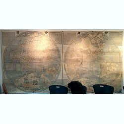
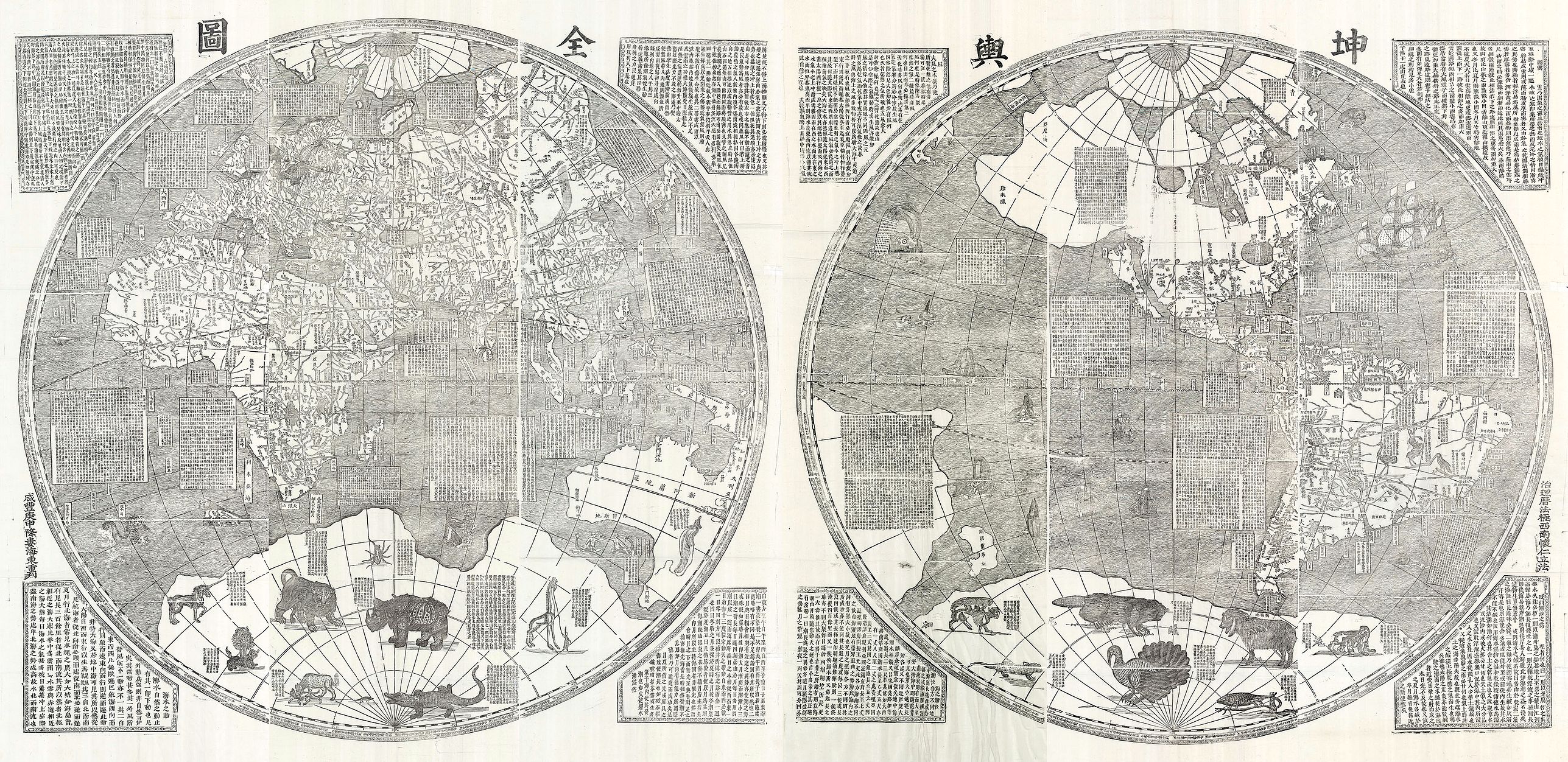
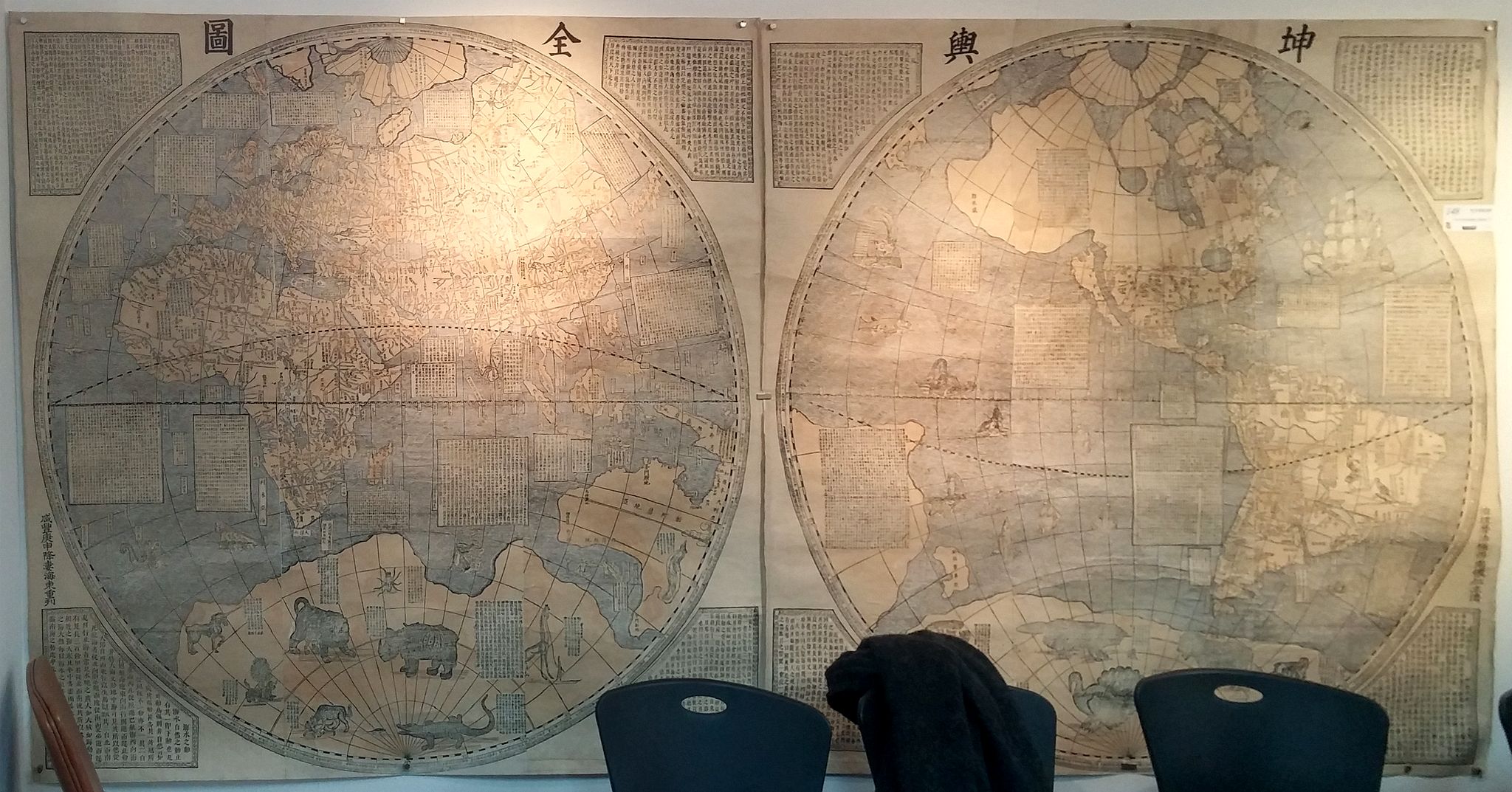
Kun-yü ch'üan-t'u. 坤與全圖 (A Map of the Whole World) |
||||||||||||||||||||
|
||||||||||||||||||||
|
|
||||||||||||||||||||
|
|
Virtual Collection - Save and collect this or any of your favorite items in one place.
If you want to save the items permanently, please sign in or create account first. |
|||||||||||||||||||
Description
Kunyu quantu 坤與全圖 (A Map of the Whole World), was first produced in 1674 by the Jesuit Father Ferdinand Verbiest 南懷仁 (1623- 1688). Commissioned by the Second Qing Emperor Kangxi 康熙 (1654- 1722, r. 1661- 1722), it is one of the largest woodblock printed maps of its type.
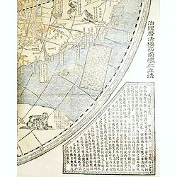
Fine wood-engraved twelve-sheet Sino-centric world map, the southern polar landmass embellished with animals, including a unicorn, a lion, a rhinoceros, a crocodile, a giraffe, a beaver and a turkey, the spandrels with eight large lozenges with text descriptions.
Originally prepared by the Flemish scientist Ferdinand Verbiest who joined the Jesuit order in 1641.
This reprint published in Seoul is easily distinguished from 1674 by the addition of a new imprint in Chinese and by the fact that the text in the spandrels of the original is within differently-shaped frames.
There was a reprint in 1860 and this one of 1933. - All versions are extremely rare.
This item is printed from the Seoul, 1860 edition blocks, now residing in the Kyujanggak Collection, Library of Seoul National University. There are very few tangible differences between the two Seoul editions.
It consists of two hemispheres, reversing the conventional European positioning so that China and the Pacific are toward the center, with the prime meridian running
through Beijing.
Ferdinand Verbiest traveled to Macao in 1659, where he studied Chinese and Confucian classics and took his final religious vows. He was a polymath best known for this Chinese world map, a revised Chinese calendar, and astronomical works in Chinese and Latin.
Notwithstanding his status as a foreigner he developed an unusually close relationship with the Kangxi emperor, who conferred mandarin rank on Verbiest and granted him an official funeral. For the emperor, cartography was a significant expression of his control over the regions under the imperial domain. Verbiest's world map drew from contemporary Dutch maps and Chinese sources, but it presented the world in a format appropriate to a Chinese audience.
Counter to Western mapmaking traditions that focused on Europe, the Kunyu quantu deferred to local conventions by placing China at the symbolic center, surrounded by countries that could be construed as tributary states" (Getty Museum online).
In 1647 Ferdinand Verbiest produced one of the largest double hemisphere maps of the world to date.
Descriptive cartouches explain geographic details and peculiarities of countries and oceans, as well as describing natural phenomena such as eclipses and earthquakes. Columbus' discovery of America is also discussed. The likely source for Verbiest's map was Joan Blaeu's monumental world map of 1648, Nova Totius Terrarum Orbis Tabula. Although the delineation of China differs, the maps are similar in size and a comparison and a concordance of geographical names shows clearly the relationship between the two maps. In total twenty-three different animals, believed to be unknown or little-known in China, decorate the margins.
The illustrations were derived from Konrad Gessner's Historia animalium (1551) and this part of the map became most influential - the illustrations and their descriptions were copied into the imperial encyclopedia T'u-shu chi-ch'eng of 1723 and the transliterated names included in Chinese and Manchu dictionaries.
The map represents the geographical and cartographical thoughts of Europeans that have
influenced in China in the seventeenth century and is a good example of the cultural exchange
between European and Chinese Cartography, by means of the activities of the Jesuits.
Literature: Exhib. Cat. Chinese and Japanese Maps (British Library, 1974) C11; Hartmut Walravens, “Father Verbiest’s Chinese World Map (1674),” Imago Mundi 43: 31-47.
Only available in Korea.
Fine wood-engraved twelve-sheet Sino-centric world map, the southern polar landmass embellished with animals, including a unicorn, a lion, a rhinoceros, a crocodile, a giraffe, a beaver and a turkey, the spandrels with eight large lozenges with text descriptions.
Originally prepared by the Flemish scientist Ferdinand Verbiest who joined the Jesuit order in 1641.
This reprint published in Seoul is easily distinguished from 1674 by the addition of a new imprint in Chinese and by the fact that the text in the spandrels of the original is within differently-shaped frames.
There was a reprint in 1860 and this one of 1933. - All versions are extremely rare.
This item is printed from the Seoul, 1860 edition blocks, now residing in the Kyujanggak Collection, Library of Seoul National University. There are very few tangible differences between the two Seoul editions.
It consists of two hemispheres, reversing the conventional European positioning so that China and the Pacific are toward the center, with the prime meridian running through Beijing.
Ferdinand Verbiest traveled to Macao in 1659, where he studied Chinese and Confucian classics and took his final religious vows. He was a polymath best known for this Chinese world map, a revised Chinese calendar, and astronomical works in Chinese and Latin.
Notwithstanding his status as a foreigner he developed an unusually close relationship with the Kangxi emperor, who conferred mandarin rank on Verbiest and granted him an official funeral. For the emperor, cartography was a significant expression of his control over the regions under the imperial domain. Verbiest's world map drew from contemporary Dutch maps and Chinese sources, but it presented the world in a format appropriate to a Chinese audience.
Counter to Western mapmaking traditions that focused on Europe, the Kunyu quantu deferred to local conventions by placing China at the symbolic center, surrounded by countries that could be construed as tributary states" (Getty Museum online).
In 1647 Ferdinand Verbiest produced one of the largest double hemisphere maps of the world to date.
Descriptive cartouches explain geographic details and peculiarities of countries and oceans, as well as describing natural phenomena such as eclipses and earthquakes. Columbus' discovery of America is also discussed. The likely source for Verbiest's map was Joan Blaeu's monumental world map of 1648, Nova Totius Terrarum Orbis Tabula. Although the delineation of China differs, the maps are similar in size and a comparison and a concordance of geographical names shows clearly the relationship between the two maps. In total twenty-three different animals, believed to be unknown or little-known in China, decorate the margins.
The illustrations were derived from Konrad Gessner's Historia animalium (1551) and this part of the map became most influential - the illustrations and their descriptions were copied into the imperial encyclopedia T'u-shu chi-ch'eng of 1723 and the transliterated names included in Chinese and Manchu dictionaries.
The map represents the geographical and cartographical thoughts of Europeans that have
influenced in China in the seventeenth century and is a good example of the cultural exchange
between European and Chinese Cartography, by means of the activities of the Jesuits.
Literature: Exhib. Cat. Chinese and Japanese Maps (British Library, 1974) C11; Hartmut Walravens, “Father Verbiest’s Chinese World Map (1674),” Imago Mundi 43: 31-47.
Only available in Korea.
FAQ - Guarantee - Shipping
Buying in the BuyNow Gallery
This item is available for immediate purchase when a "Add to Cart" or "Inquire Now" button is shown.
Items are sold in the EU margin scheme
Payments are accepted in Euros or US Dollars.
Authenticity Guarantee
 We provide professional descriptions, condition report (based on 45 years experience in the map business)
Paulus Swaen warrants the authenticity of our items and a certificate of authenticity is provided for each acquired lot.
Condition and Coloring
We indicate the condition of each item and use our unnique HiBCoR grading system in which four key items determine a map's value: Historical Importance, Beauty, Condition/Coloring and Rarity.
Color Key
We offer many maps in their original black and white condition. We do not systematically color-up maps to make them more sellable to the general public or buyer.
Copper engraved or wood block maps are always hand colored. Maps were initially colored for aesthetic reasons and to improve readability. Nowadays, it is becoming a challenge to find maps in their original colors and are therefor more valuable.
We use the following color keys in our catalog:
Original colors; mean that the colors have been applied around the time the map was issued.
Original o/l colors; means the map has only the borders colored at the time of publication.
Colored; If the colors are applied recently or at the end of the 20th century.
Read more about coloring of maps [+]
Shipping fee
A flat shipping fee of $ 30 is added to each shipment by DHL within Europe and North America. This covers : International Priority shipping, Packing and Insurance (up to the invoice amount).
Shipments to Asia are $ 40 and rest of the world $50
We charge only one shipping fee when you have been successful on multiple items or when you want to combine gallery and auction purchases.
Read more about invoicing and shipping
FAQ
Please have a look for more information about buying in the BuyNow gallery
Many answers are likely to find in the general help section.
Virtual Collection
![]()
With Virtual Collection you can collect all your favorite items in one place. It is free, and anyone can create his or her Virtual map collection.
Unless you are logged in, the item is only saved for this session. You have to be registed and logged-in if you want to save this item permanently to your Virtual Collection.
Read More[+]
Register here, it is free and you do not need a credit card.
Add this item to
Virtual Collection
or click the following link to see my Virtual Collection.
| Digital Image Download | |
|
Paulus Swaen maintains an archive of most of our high-resolution rare maps, prints, posters and medieval manuscript scans. We make them freely available for download and study. Read more about free image download |
Click the image for a free small image download. |
In accordance with the EU Consumer Rights Directive and habitually reside in the European Union you have the right to cancel the contract for the purchase of a lot, without giving any reason.
The cancellation period will expire 14 calendar days from the day after the date on which you or a third party (other than the carrier and indicated by you) acquires, physical possession of the lot. To exercise the right to cancel you must inform Paulus Swaen Inc, of your decision to cancel this contract by a clear statement (e.g. a letter sent by post, or e-mail (amsterdam@swaen.com).
To meet the cancellation deadline, it is sufficient for you to send your communication concerning your exercise of the right to cancel before the cancellation period has expired.