Subscribe to be notified if similar examples become available.
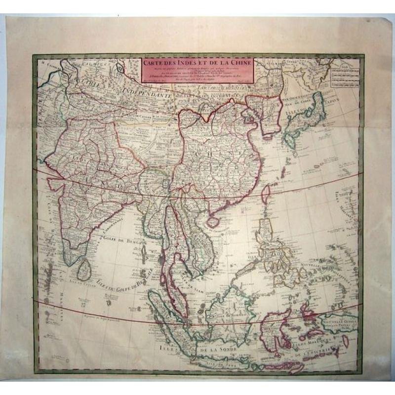
CARTE DES INDES ET DE LA CHINE. |
||||||||||||||||||||
|
||||||||||||||||||||
|
|
||||||||||||||||||||
Estimated value: $400 - $550 |
My Collection +
Add this or any of your favorite items in one place. If you want to save the items permanently, you have to sign in or create an account first. |
|||||||||||||||||||
Description
De L’Isle’s detailed and exceptional map of South-East Asia showing both the East Sea and the Sea of Korea. An updated example of this noteworthy map of East Asia and the Indian subcontinent was published by France’s foremost eighteenth-century cartographer, Guillaume De L’Isle. Here present in edition by one of Delisle's successors Dezauche.
The map was foundational; it was studied and adopted by other mapmakers for a half-century after its publication.
The map covers much of Asia, from China and Japan, south to New Guinea and the Moluccas, west through Malaysia and Indonesia to what is today's Vietnam and Thailand, and India. Dotted lines mark political boundaries. There is a simple title cartouche in the top center, with a quadruple scale bar in the upper right corner.
The map is thickly detailed with settlements, geographic features, and ethnographic notes. For example, on the island of Borneo, the third-largest island in the world, a note reads, “Pays de Mahometans,” or country of Muslims. Islam arrived on the island in the tenth century via Muslim traders; it quickly spread around the island, especially under the sultanates of Brunei and Sulu.
While most of the outlines of the continent appear familiar to the modern eye, the landmass north of Japan is curious. Here, it is called “Terre de Yeco ou d’Eso.” Yeco is a reference to Jesso, a feature included on many seventeenth and eighteenth-century maps. Historically, Eso (Jesso, Yedso, Yesso) refers to the island of Hokkaido. It varies on maps from a small island to a near-continent-sized mass that stretches from Asia to Alaska.
Ever cautious, De L’Isle has left the southernmost tip of the land open, as is the northernmost tip of Japan, as contemporary geographers thought they might be connected.
This map is a useful reference to Asia’s past and was skillfully executed by France’s foremost geographer. It is an important work, which would be copied by other mapmakers for more than fifty years.
Guillaume De L'Isle (1675-1726) is probably the greatest figure in French cartography. Having learned geography from his father Claude, by the age of eight or nine he could draw maps to demonstrate ancient history. He studied mathematics and astronomy under Cassini, from whom he received a superb grounding in scientific cartography—the hallmark of his work. His first atlas was published in ca. 1700. In 1702 he was elected a member of the Academie Royale des Sciences and in 1718 he became Premier Geographe du Roi.
De L'Isle's work was important as marking a transition from the maps of the Dutch school, which were highly decorative and artistically orientated, to a more scientific approach. He reduced the importance given to the decorative elements in maps, and emphasized the scientific base on which they were constructed.
His maps of the newly explored parts of the world reflect the most up-to-date information available and did not contain fanciful detail in the absence of solid information. It can be fairly said that he was truly the father of the modern school of cartography at the commercial level.
De L’Isle also played a prominent part in the recalculation of latitude and longitude, based on the most recent celestial observations. His major contribution was in collating and incorporating this latitudinal and longitudinal information in his maps, setting a new standard of accuracy, quickly followed by many of his contemporaries. Guillaume De L’Isle’s work was widely copied by other mapmakers of the period, including Chatelain, Covens & Mortier, and Albrizzi.
FAQ - Guarantee - Shipping
994 BuyBidBuying in the BuyNow Gallery
This item is available for immediate purchase when a "Add to Cart" or "Inquire Now" button is shown.
Payments are accepted in Euros or US Dollars. We accept most major credit cards, PayPal and bank transfer.
Authenticity Guarantee
 We provide professional descriptions, condition report and HiBCoR rating (based on 45 years experience in the map business)
We fully guarantee the authenticity of items we sell. We provide a certificate of authenticity for each purchased item.
Condition / Coloring
We indicate the condition of each item and use our unnique HiBCoR grading system in which four key items determine a map's value: Historical Importance, Beauty, Condition/Coloring and Rarity.
We offer many maps in their original black and white condition. We do not systematically color-up maps to make them more sellable to the general public or buyer.
Copper engraved or wood block maps are always hand colored. Maps were initially colored for aesthetic reasons and to improve readability. Nowadays, it is becoming a challenge to find maps in their original colors and are therefor more valuable.
We use the following color keys in our catalog:
Original colors; mean that the colors have been applied around the time the map was issued.
Colored; If the colors are applied recently or at the end of the 20th century, then "colored", or "attractive colors" will be used.
Original o/l colors; means the map has only the borders colored at the time of publication.
Read more about coloring of maps [+]
FAQ
Please have a look for more information about buying in the BuyNow gallery.
Many answers are likely to find in the general help section.
My Collection+
![]()
With My Collection+ you can collect all your favorite items in one place. It is free, and anyone can create his or her virtual map collection.
Unless you are logged in, the item is only saved for this session. You have to be registed and logged-in if you want to save this item permanently to My Collection+.
Read More [+]
If you want to save the items permanently, please sign in
or create account first. ![]()
Registering Here, it is and you do not need a credit card.
Add this item to
My Collection+
or click the following link to see My Collection+.
Invoice
The invoice and certificates of authenticity are available in the client center >Invoices
| Digital Image Download | |
|
Paulus Swaen maintains an archive of most of our high-resolution rare maps, prints, posters and medieval manuscript scans. We make them freely available for download and study. Read more about free image download |
Click the image for a free small image download. |
In accordance with the EU Consumer Rights Directive and habitually reside in the European Union you have the right to cancel the contract for the purchase of a lot, without giving any reason.
The cancellation period will expire 14 calendar days from the day after the date on which you or a third party (other than the carrier and indicated by you) acquires, physical possession of the lot. To exercise the right to cancel you must inform Paulus Swaen Inc, of your decision to cancel this contract by a clear statement (e.g. a letter sent by post, or e-mail.
To meet the cancellation deadline, it is sufficient for you to send your communication concerning your exercise of the right to cancel before the cancellation period has expired.
