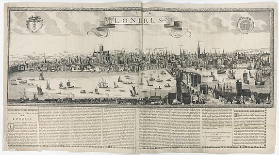
Londres 1678. [Panoramic view of London in 1678]
POR / Contact us
Extremely rare panoramic broadsheet town view of London from Whitehall to the Tower, with a letterpress description of the town's history beneath. The only other known copy, but without the text below, is preserved at the British Museum under number 1880,1113.1153.The view measures more than 1 meter.
Based on Claesz Jansz Visscher's (1587-1652) "excudit" panorama published in about 1620, the only extant example of which is housed in the Folger Shakespeare Library in Washington.
London extends from Whitehall in the west to St Katherine's by the Tower in the east. It is presented as an industrious and prosperous city. The Thames teems with all manner of sailing vessels, fit for passengers, trade, and war: ferries, wherries, barges, pinnaces, barks, and galleons. The river Thames in the foreground is animated with a great variety of vessels. It shows London as it was at the beginning of the seventeenth century, taken from Southwark, looking north.
The text below provides information on the city's history, its geographical position, the River Thames, and its role as England's principal political and commercial hub.
The printer's address is dated 1677, but the tile has the date 1678. Lettered on a plate with the title on a ribbon at the top with the date 1678, between two cartouches, one with the caduceus of Mercury, the other with a Crucifix entwined by a tendril in the shape of the letter S; within the image, numerous place names.
Reference: Irene Scouloudi, "Panoramic Views of London 1600-1666", 1953, p. 41, describes this town view as a version of the long view by Visscher. This is the only impression of this version that she records.
