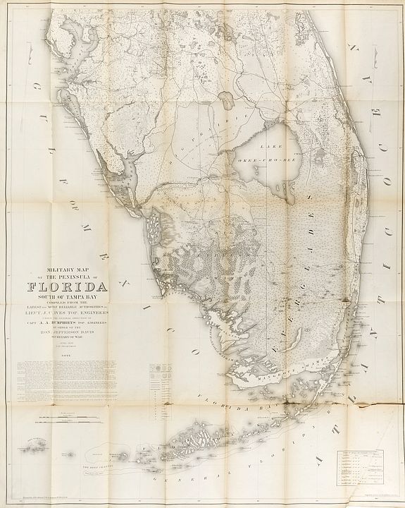
Military Map of the Peninsula of Florida South of Tampa Bay...
New York, 1856. 1060 x 830 mm. Large pocket folding map bound into its original gilt-lettered cloth covers. One of the blank leaves of the memoir has a presentation in brown ink "with the compliments of J.C. Ives Lieut: Jop: Eups U.S. Army".
FIRST EDITION of this large cornerstone map of Florida, produced during the Third Seminole War. The map was issued to illustrate "Memoir to accompany a Military Map of The Peninsula Of Florida", published in April 1856 under orders from Secretary of War Jefferson Davis and compiled by Lieut. Joseph C. Ives, this map and accompanying memoir represent the most advanced military and topographical rendering of southern Florida issued before the Civil War.
The main areas of activity during the Third Seminole War, the territory just west of Lake Okeechobee, and the northern end of Big Cypress Swamp, are shown in incomparable detail.
Ives shows all local Indian settlements, along with the locations and dates of relevant skirmishes and battles up to April 1856.
Third Seminole War.
 The third and final Seminole War started when a surveying expedition under the command of Lieutenant Hartsuff, stumbled upon a garden owned by Billy Bowlegs, an important local Seminole chief.
Hartsuff's party began destroying the garden, and Bowlegs discovered them doing so. He objected to the destruction of his crops and was brutalized by the soldiers. While Hartsuff's team was preparing to leave for Fort Myers the next morning, they were attacked by Bowlegs and a group of Seminole warriors.
Four of the eleven members of the party were killed and scalped, while the rest were able to make it back to Fort Myers.
Hartsuff's route and the location of the skirmish are both noted on this map. The war continued for three years.
Bowlegs was eventually persuaded to accept a cash payment from the United States government, and he relocated his people west to the Indian Territory, now Oklahoma.
It is said that when they went through New Orleans on their way to the Indian Territory, Bowlegs had two wives, several children, $100,000 in cash, and many slaves with him. When Bowlegs established himself in the Indian Territory, he was said to be among the larger slaveholders in the region.
The small territory that was still occupied by the Seminole Indians at the outset of the third war, is described on this map in great detail.
The map shows the extent to which the Indians had been pushed deep into Big Cypress Swamp and up to the northern edge of the Everglades by the previous wars and the policies of Andrew Jackson.
Ives gives a good sense of the distribution of the Seminoles who had remained in Florida to the mid-1850s with the depiction of the villages in Big Cypress Swamp: Billy's Town, Billy Bowlegs Old Town, Sam Jones Town, Bowlegs Town, Stuttering Bill's, etc. At least seven battlegrounds from the Second and Third Seminole Wars are shown on the map. They date up to 1856 and include the following: Battle of Okeechobee December 25, 1837 Jesup's Battle January 24, 1838 Battle of December 20, 1841 Lieut. Hartsuff's Skirmish of December 1855 (marking the beginning of the third war) Battle of January 1856 Battle of April 7, 1856 Battle of March 29, 1856 (the map was published the following month) The map illustrates over 45 forts or military depots.
Interestingly the vast majority of these are unoccupied; of the forts shown, only nine are labeled occupied on the map. The map illustrates the following occupied forts: Fort Deynaud Fort Capron Fort Green Fort Hartsuff Fort Dulaney Fort Simon Drum Fort Dallas Fort Frazer Fort Meade and these unoccupied forts: Fort Lauderdale Old Fort Lauderdale Fort Jupiter Old Fort Jupiter Fort T. B. Adams Fort Thompson Fort Pierce Fort Loyd Fort Van Swearingen Fort Drum Fort Vinton Fort Kissimmee Fort Chokkonikla Fort Myakka Fort Arbuckle Fort Clinch Fort Keais Fort Doane Fort Shackelford Fort Myers Fort Hamer Fort Crawford Fort Brooke Fort Carroll Fort Chokkonikla Fort Harrell Fort McRae Fort Westcott Fort Simmons Fort Center Fort Henry Old Depot No. 2 Temporary Depot No. 1 Temporary Depot No. 2 / Old Fort Foster Fort Basinger Fort Gardner.
In addition to the battles and forts described on the map, its other major contribution to our understanding of the military history of South Florida is its inclusion of the routes of 25 military surveys and expeditions spread between the Second and Third Seminole Wars.
The routes are as follows: Screven's route Major Lauderdale's route Colonel Harney's route Colonel Taylor's route General Twigg's route Colonel P. Smith's route Captain Waites's route Captain Wright's route General Eustis's route Captain Pratt's route Colonel Taylor's route Lieutenant Hartstuff's route of 1835 Captain Allen's route of 1838 Colonel Davenport's route of 1839 Major Graham's route of January 1842 Captain Wade's route of 1842 Captain Wade's return route Captain Ker's route of 1842 Lieutenant Benson's route of 1854 Captain Dawson's route of 1855 Lieutenant Haines's route 1855 Major Hays's route 1855 Lieutenant A.P. Hill's route of 1855 Lieutenant Platt's route of 1855 Major Hayes's route of 1855
The map features a stunning level of ecological detail; six categories of land are differentiated: sawgrass, swamp, marsh, scrub, wet prairie, dry prairie, wet hammock, and dry hammock.
The map also specifies the following forest types: pine, palmetto, oak, cypress, and "koontee" (also called "koonti", and now referred to as Florida arrowroot or wild sago). The map's coverage of the entirety of the Everglades and surrounding areas, as well as the present-day metropolitan areas of Miami, Palm Beach, Tampa Bay, and Fort Myers, offers a peerless opportunity to contrast south Florida's pre-development landscape with how it looks today. The map shows very few American towns.
Tampa is shown as a village and there are single dwellings scattered around the bay but other than that there is very little development. There are collections of houses near Indian River and in the Florida Heartland. In fact, there were few enough houses that Ives could name the individual owners of many of them.
Two lighthouses are shown, namely those on Key West and at Cape Florida on Key Biscayne.
Particular care was taken to describe various transportation routes: wagon roads, blazed routes, and trails are shown separately. Indian boundaries are shown. There are proposed canal routes as well. Joseph Christmas Ives The map was compiled by Joseph Christmas Ives (1829-1868), under the orders of then-Secretary of War of the United States, Jefferson Davis. Ives was an important figure in the mapping of the American frontier.
He graduated from the United States Military Academy in 1852, and from 1853 to '54 he served as a Second Lieutenant with the Topographical Engineers on Whipple's Pacific Railroad survey of the 35th parallel. After the completion of his map of Florida in April 1856, Ives led an expedition over two years, to explore the upper Colorado River. As a result of this expedition he was responsible for the earliest scientific mapping of the Grand Canyon and its environs. From 1859 to 1860, after his expedition out west, Ives worked as an engineer and architect on the Washington Monument. At the beginning of the Civil War he declined a promotion in the U.S. Army. And in spite of having been born in New York City, Ives took a commission with the Confederates. He filled several engineering roles until he became aide-de-camp, with the rank of colonel, to President Jefferson Davis. He served in this capacity from 1863 to 1865. It is noteworthy that he also served under Jefferson Davis when Davis was Secretary of War during the 1850s. It has been suggested that this relationship is what led Ives to fight for the Confederacy.
The memoir opens with a comprehensive introductory section that articulates the problems faced by military surveyors in Florida: much of the terrain is submerged for part of the year, and most maps had been drawn either without instruments or under duress. Ives justifies the need for a consolidated topographic and logistical view, and the introductory remarks demonstrate a surprisingly modern awareness of the limitations of cartographic data and the variability of field conditions.
The body of the memoir is organized into a sequence of firsthand route descriptions based on detailed fieldwork. Each section is titled by its route, including:
Introductory Remarks.
Inland Route from Fort Capron to Fort Jupiter, Inland Routes from Fort Jupiter to Fort Lauderdale.
Route from Fort Lauderdale to Fort Dallas.
Routes from Fort Dallas to the Western Border of the Everglades.
Routes through the Big Cypress Swamp.
Routes from the Big Cypress Swamp to the Caloosa-hatchee River.
Route from Fort Thompson to Fort Meade.
Route from Fort Meade to Fort Myers.
Route from Fort Mayers to Fort Jupiter.
The text of his memoirs is very interesting and we provide below its contents:
INTRODUCTORY REMARKS.
A CONSIDERABLE portion of the State of Florida, south
of Tampa Bay, is a comparatively unknown region. Its
natural features oppose great obstacles to the prosecution of
surveys and explorations; and, although many have been
from time to time accomplished under the direction of dif-
ferent commanding officers of the troops stationed there, the
results have not all been connected, nor embodied into an
available form. Sketches of the country have been made,
undoubtedly in all cases, by officers who have accompanied
the examinations, and these have subsequently been com-
piled, and, where authority was given for it, published.
The maps thus furnished have, however, been necessarily
constructed upon a scale too small to exhibit more than the
general features of the country, and the lines traversed have
been plotted from surveys made either without instruments
or with those of the roughest description. The written reports, which would give more specific and complete details and supply information that the surface of a map could not,
have rarely been published, and have existed only in the
archives of the department. They could not therefore be
made available to officers in the field, and would be, under
any circumstances, difficult to refer to ; for, many of them
relating to expeditions undertaken for other objects than the
exploration of the country, the material collected, at different times, in regard to the topography, would be scattered
throughout numerous and extended reports, embracing other
subjects, and covering a long interval of time. As a large
portion of the region is submerged during some seasons of
the year, trails and other local marks are soon obliterated ;
and, when new troops have been ordered into the country,
they have been obliged to purchase the knowledge, possessed
by their predecessors, with a fresh expenditure of time, hard-
ship and danger. Extensive reconnoissances were made
along the coast and in the interior, during the years 1841
and 1842, at which time the south-eastern and south-western
shores, the Everglades, the Big Cypress Swamp, Lake Okee-
chobee, and the adjacent region, were traversed in various
directions by ofiicers of the army and navy, and much ac-
complished towards the topographical development of the
State. Many similar explorations, some of them attended
with great difficulties, have been recently made, under the
direction of Cols. Munroe and Brown, Second Artillery, by
the ofl&cers of their commands. JViost of these have appeared
to be over an unexamined country, though a comparison of
the reports and sketches with those that were made in 1842
shows that some of the routes passed over at the two periods
must have been nearly identical. Had the parties last in the
field possessed, in a form suitable for reference, all of the in-
formation gathered by those who preceded them, their labors
would probably have been much lightened.
During the compilation of the accompanying map, a num-
ber of reports, made by the officers above referred to, have
been obtained from the Adjutant General's Department, and
it has been thought desirable, from the considerations
mentioned, to extract the topographical information con-
tained in them, and to present it in a connected form. Such
material as could be procured from other reliable sources has
been appended. The short time allowed for the work has
precluded anything like a thorough investigation as to what
is now known of the region in question; those facts only
INLAND ROUTE FROM FORT CAPRON TO FORT JUPITER.
being presented which were at hand or could without delay
be collected. For convenience of reference and to conform
as nearly as possible to the original reports, the lines of com-
munication referred to in them have been separately taken
up, and in connection with these is mentioned whatever
could be learned concerning the adjacent localities. The
country considered being, for the greater part, a flat expanse,
where the prairie of one day may at another be converted
into a lake, and where the lakes, rivers, swamps and ham-
mocks are subjected to such changes as can be produced by
an additional layer of water of a depth sometimes as great
as three feet, all statements relating to its surface are liable
at times to considerable modifications.
INLAND ROUTE FROM FORT CAPRON TO FORT JUPITER.*
Fort Capron is situated on the west bank of Indian River,
opposite to Indian River Inlet. The site of the post is upon
hard ground, a few feet above the surfce of the water. The
Inlet is open. The bar at its mouth can be crossed by
vessels whose draught is not greater than four and a half
feet. The location is a healthy one at all seasons of the year.
Half a mile back from the Fort runs a small ridge, its general
♦This route was traversed and reported upon by Maj. Prince, U. S. A., in 1P54 and by
Lieut. Hill, First Artillery, in 1855. The description of it here given is an abridgment of the two
reports; the former of which was obtained from the records of the U. S. Coast Survey, and
the latter from the Adjutant General's Department, U. S. A.
INLAND ROUTE FROM FORT CAPRON TO FORT JUPITER.
direction being nearly parallel to the line of the coast, ex-
tending northward to the head of Indian Eiver, and south
almost to St. Lucie Point, at the junction of St. Lucie River
with St. Lucie Sound. To this place, about twenty-three
miles below Fort Capron, the river is a straight reach of
water, varying in width from one to three miles, exposed to
the wind, and navigable for full four feet draught. Four
miles and a half from Fort Capron, the ridge above referred
to comes to the water, forming a bank, twenty feet in height,
which is the site of Fort Pierce. The growth on the shore,
between the two forts, is pine. South of the latter post the
ridge is covered with hammock growth, and, two miles below,
rises to the height of forty feet, where is the old Indian
Garden. Along the ridge, in this vicinity, are a few dwell-
ing houses : the inhabitants of these, with the light hou?e
keeper at Cape Canaveral, are the only settlers upon the
coast, from the canal, ninety miles above Fort Capron, to the
Miami River^ more than a hundred miles below.
Nine miles south of the Indian Garden, there is a high
point of the ridge, which is bare and dotted with patches of
white sand, ("bleach yard,") and, two miles below, at Mount
Elizabeth^ pine growth again appears upon the shore ; the
ridge receding towards the St. Lucie River. Between Mount
Elizabeth and Fort Pierce, it borders the river, formijag
a steep high bank, covered with cabbage, palmetto, and
other hammock growth. Along the top is a narrow strip of
cultivable ground, from which there is a rapid descent, in-
land, to an open country, covered with flagponds, savannas,
sawgrass, marshes, and palmetto flats, with a few scattered
pines.
From Fort Capron, the beach on the inside is remarkably
serrated, and lined with high mangroves that shut out
the view towards the ocean.
The St. Lucie flows between banks formed of coquina*
A concrete of shells.
INLAND ROUTE FROM FORT CAPRON TO FORT JUPITER.
rocks and rising about six feet above the water's edge.
Along these is a growth of palmettos, and the neighborhood
is a famous resort for turkeys and the manatee.
Upon leaving St. Lucie point two openings present them-
selves. The one to the left is that which is to be followed;
being the entrance to the Jwpiter Narrows. This entrance is
opposite to Gilbert's Bar, which is now closed, as there is
little more than one foot of water upon it at the highest tides.
Following the channel somewhat over a mile, it opens into a
bay three-quarters of a mile broad, and about two miles in
length ; the western shore of which must be coasted till a
narrow opening, not exceeding twenty feet in width, is per-
ceived. This baj'ou continues but a short distance before it
is joined by another, somewhat wider, from the right.
The Narrows are exceedingly tortuous, winding in large
bends through swamps grown up with, lofty mangroves full
sixty feet in height, whose branches nearly meet from the
opposite sides of the stream. The water is of considerable
depth, and the current strong, setting either way with the
wind, the prevailing direction of which along this portion of
the coast, for six months of the year, is south east. The
Narrows extend about six miles, terminating at Hole Sound.
At this point lies an extensive oyster bed, that precludes the
passage of boats drawing more than three feet.
Hobe Sound is skirted on the west by high hills covered
with oak scrub, while the beach that borders the opposite
side is a thick hammock that extends four and a half miles
to the south. Where the hammock ends, there is a narrow
place in the sound, occasioned by a sharp point of mangroves
which puts out from the west shore from near the base of a
hill, sixty feet in height, that rises rapidly from the water.
This place is called Couch's har, and the greatest depth of
water upon it is about three feet.
The Sound is sufficiently exposed to the wind to admit of
the use of sails, and in most places is easily navigated by
vessels of four feet draught. It extends for eight miles to
2
INLAND ROUTES FKOM FORT JUPITER
Jupiter River from the mouth of which it is about two and
a half miles to the site of Fort Jupiter.
The total distance from Fort Capron to Fort Jupiter, is
about forty miles. The Mackinac boats, sometimes employed
upon this route, are said to be unsuitable for the transporta-
tion of troops and supplies between the two posts; having to
lay by during a hard wind, and under the most favorable
circumstances requiring four days to accomplish the trip.
The kind of vessel recommended, as likely to be most ser-
viceable, is a small sloop, not drawing over three feet when
loaded, and made after the pattern of the old s urf boats,
used, during the Mexican war, at Vera Cruz.
INLAND ROUTES FROM FORT JUPITER TO FORT LAUDERDALE.*
Old Fort Jupiter stands upon the southern shore of Jupiter
Elver, about three miles from the bar at the mouth of the
Inlet. It is upon the western point, formed by the junction
of Jupiter River and Jones's Creek^ a stream that rises three
or four miles to the south. The land in the immediate vi-
cinity is grown up with thick scrub, and is bare of timber.
The back country is a high pine region, through which the
* The information here given is taken from a. journal kept by Lieut. Humphreys, Topogra-
phical Engineers, while passing over the line, in company with Capt. Wade's command, in
1H41. The description of the localities in the immediate neighborliood of Fort Jupiter, is
from the reports, already referred to, of Major Prince, and Lieut, Hill, First Artillery.
TO FORT LAUDERDALE.
old road to Fort Von Swearingen may still be distinctly
traced. Half a mile distant from the old Fort, upon the
eastern point made by the creek and river, is the new post,
now called Fort Jupiter. Here the pine land is still niore
elevated, and continues so for five miles back; the timber
coming down to the water's edge, and the water itself being
of sufficient depth for small boats, close in to the shore.
Abundance of wood, suitable for building purposes, can be
conveniently obtained. The soil is fertile. There is an ex-
cellent anchorage, and a good place for loading and unload-
ing boats, making the site of the present Fort preferable to
that of the old one, or any other location in the vicinity.
Objections exist to it now as a military position, from the
fact that the Inlet is closed, and the post rendered inaccessi-
ble, from the sea, to the smallest coasting vessels. The clos-
ing of the inlet causes the locality— at other times salubrious
—to be an unhealthy one ; the water on the inside of the bar
then becoming fresh, and inducing a rapid growth of vege-
table matter, which, decaying, taints the atmosphere and en-
genders disease. The alternate opening and closing of this
inlet is somewhat remarkable. Between the years 1840 and
1844, it was closed. At the latter period, Capt. Davis, the
mail carrier from Fort Capron to Cape Florida, endeavored,
with a party of four men, to excavate a channel. After
digging for several hours, they succeeded by nightfall in
starting outward a stream of water four inches in depth.
Upon this they desisted from labor and went to their camp,
which was some fifty feet from the ditch. The river inside
was unusually high, from a freshet in the everglades, and a
strong north wind was blowing. At night, the sleeping par-
ty were awakened by a flood of water, and had to abandon
their camp equipage and run for their lives, barely escaping
being carried out to sea. The next day there was a channel
nearly a quarter of a mile wide, and the rush of water could
be traced far out upon the ocean.
The inlet stayed open till 1847, when it closed till 1853.
INLAND ROUTES FROM FORT JUPITER
during which year it opened itself, but remained in that con-
dition only a short time. In 1855, Maj. Haskin, First Artill-
ery, in command of the post, endeavored again to clear the
channel. Sand hills of considerable size, which had accumu-
lated, were cut through, and the attempt would doubtless
have been successful but for the low condition of the water
during that unusually dry year. A small amount of labor
expended under favorable circumstances would, in all proba-
bility, eifectually open this inlet, and render the harbor one
of the best upon the eastern coast. At times it has admitted
vessels drawing eight feet, and the entrance is protected from
north winds by a ledge of rocks.
Tioo inland ivater routes have been explored, between Forts
Jupiter and Lauderdale; one, very near to the coast, and the
other, some miles towards the interior. These were traversed,
during the month of December, IS-tl, by Capt. Wade, with
a command of eighty men. Both of the routes leave Jupiter
Eiver b}^ Lake Worth creek^ the mouth of which is a mile
and a half below the post. This stream, like most of the
rivers in Florida, is exceedingly crooked, and, where it emp-
ties into Jupiter River, is one hundred yards wide, and
several feet in depth. It runs almost due north, with a
strong current. Pine barren lines either bank for five miles,
when on the east side a growth of sawgrass commences, ex-
tending to the sea shore, which is about two miles distant.
On the west the pine barren continues, but recedes a quarter
of a mile back from the creek, which, at this place, is only
forty feet wide.
Two miles higher up, the two routes to Fort Lauderdale
diverge. The stream being no longer navigable — except at
YQry high water, when there is sometimes a practicable chan-
as far as Lake Worth — it is necessary, in following the coast
route, to pull the boats three-quarters of a mile in a south-
easterly direction, through a sawgrass pond, to a haulover,
four hundred yards across, which leads to the head of the
TO FORT LAUDERDALE.
lake. Over this haulover, Capt. Wade's command, with
seventeen canoes, was three hours in passing.
Lake Worth is a pretty sheet of water, about twenty milps
long and three quarters of a mile in width ; bounded on the
west by pine barren, and on the east by the sand hills of the
beach, which are sometimes twelve or fifteen feet in height,
and covered with cabbage trees, wild figs, mangroves, saw
palmettos, &c., with here and there a variety of the cactus.
In the centre of the lake, a mile and a half from the head,
is an island, bearing a tree resembling the wild fig in appear-
ance, with a fruit like the olive in shape and size, of a yellow
color when ripe, and used by the Indians as food. A deli-
cate running vine is also here found, yielding a vegetable
about three quarters of an inch long, with a flavour similar
to that of the cucimiber. Opposite to the middle of the
island is a haulover, only eighty yards across, descending
twelve feet to the sea, at an angle of fortj^-five degrees. Two
miles and a half beyond is another haulover, one hundred
yards in width. Below, along the eastern border of the
Lake, are long strips of cultivable ground about two hun-
dred yards wide, separated from the beach by ponds and wet
prairie. These were formerly tilled by the Indians, who
had large villages in the neighborhood. The soil is light,
but very rich, being almost entirely vegetable mould. Kock
occasionally makes its appearance on the surface, and heaps
of sea shells are strewn here and there. The country on the
west side would afford fine grazing.
Six miles from the last haulover, on the west side of the
Lake, is Chachi's landing. A broad trail, half a mile in length,
formerly led from this place over a spruce scrub towards the
villages of the Indians whose gardens were upon the opposite
side of Lake Worth, which they reached by hauling their
canoes over the trail. The last fields were five miles from
the foot of the Lake. A small creek forms the outlet at the
southern point ; along which, at ordinary stages of the water,
boats can be paddled for only a quarter of a mile. They can
INLAND ROUTES FROM FORT JUPITER "
then be pushed along the creek to its head, half a mile beyond,
where commences asawgrass marsh through which they have
to be hauled. Half a mile of hauling brings to a small clump
of palmettos that can be seen for some miles and serves for a
landmark. Another mile through the sawgrass conducts to
a lagoon along which boats may be paddled for a, third of a
mile; the lagoon widening into a little pond that is only a
hundred and fifty yards distant from the sea. The ground
rises abruptly twelve or fifteen feet and then descends rapidly
to the surf. Under the mould which is but a few inches deep,
there is rock, three or four feet thick; in one place rup-
tured, forming a cave of twenty feet front, and extending back
fifteen feet ; the bottom covered with water. Palmettos of
enormous size and Spanish bayonets grow in the vicinity.
Near by is an old haulover, used by the Indians in moving
from Lake Worth to gather Koontee^ which grows in abun-
dance on the pine barren to the west. A narrow sluggish
sort of creek, five feet deep, extends from the pond for a quar-
ter of a mile, over which distance canoes may be pushed.
More than a mile of sawgrass marsh is then to be traversed
before reachini? the Little HilUboro.
The head of this creek is very narrow : wide enough to
allow a canoe to lie in it, but not to be turned around. The
banks are eighteen inches high, formed of snail shells and
black mould. The prairie is three quarters of a mile wide
and covered with thick grass. Canoes have to be pushed
along for a mile and a quarter, when the stream becomes
sufliciently wide to admit of paddling. A quarter of a mile
below is Orange Orove Haulover. A small mound marks the
spot, and among the trees that grow in the neighborhood are
a few wild oranges which give the place its name. The distance to the sea is about three hundred yards.
It required five days of hard labor for the eighty men in
* A vegetable somewhat resembling a large parsnip, from which, when it is reduced to a
pulp and washed, a substance like arrow root is obtained. The juice is said to have poison-
ous properties.
TO FORT LAUDERDALE.
Capt. Wade's command to haul their seventeen canoes from
the foot of Lake Worth to Orange Grove Haulover ; the
whole distance being but six miles. Twenty men were
needed, in some places, to pull a single canoe. In the saw-
grass marshes they would sink into the soft mud a foot deep
at every step, and sometimes up to their middles ; the matted
grass interposing an additional and even more troublesome
obstacle to their progress.
For two miles from the haulover the Little Hillsboro winds
through the prairie ; the width of the stream increasing grad-
ually from seven to fifty feet. To the east grow palmettos,
mangroves and wild figs, and on the west there is a pine bar-
ren, with palmettos and occasional thickets. A belt of man-
groves, one hundred feet broad, with openings to the pine
country behind, then skirts the western bank for five miles.
The river opens twice into small lakes, and increases in width
to one hundred feet, when it joins Boca Ratones.
This sheet of water is a mile and a half wide and three
quarters of a mile long. The sand bank which separates it
from the sea is, in one place, only a hundred yards wide.
Here there was once an inlet. The timbers of a ship lie buried
in what was formerly the channel. It is said b}^ the Indians
that many years ago a wrecked vessel drifted on to the bar,
and, being left there by the receding tide, formed a nucleus
about which the sand collected and closed the mouth of the
river.
The creek that forms the southern outlet from Boca Ea-
tones is twenty feet wide; mangroves growing along the
banks, whose pendant roots obstruct, to some extent, the
passage of boats ; which, as the creek narrows, have to be
finally hauled for a distance of two and a half miles along a
small and very crooked channel. This conducts to the north
branch of the Hillsboro, a stream fifty feet broad, lined with
mangroves, and increasing in size to its mouth, five miles
distant, where it is about a quarter of a mile in width.
Hillsboro Inlet runs south for a mile ; leaving a ridge of
INLAND ROUTES FROM FORT JUPITER
sand, three hundred feet wide, between it and the Ocean.
It narrows very much towards the entrance, affording a pass-
age for row-boats only. The depth of water on the bar at
low tide is about two feet. Five hundred yards from the
bar the river can generally be forded ; the water being three
feet in depth. A third of a mile from the mouth a small
creek comes in from the south. For nearly half a mile its
sides are lined with mangroves ; the stream gradually nar-
rowing from thirty to twenty feet, and running between
banks two feet in height. A mile and a half be3^ond is the
head, and here it is so narrow as scarcely to afford room for
the passage of a canoe. A grassy prairie, a mile wide and
two miles and a half long, sometimes dry and sometimes
with a few inches of water upon it, leads to the head of
another small creek. Pine barren still continues upon the
western side. At a distance of three miles the creek enters
into New Biver, on the eastern side of which — four miles
distant — is the site of Fort Lauderdale.
The second inland ivater route from Fort Jupiter to Fort
Lauderdale, as has been already stated, diverges from the one
just described, at the point where the latter leaves Lake
Worth Creek. An extensive sawgrass pond or marsh ex-
tends from this place, twelve and a-half miles south, to Cha-
chi's Village, which is a mile and a-half west of Lake Worth,
Lagoons of deep water, covered with spatterdocks, are here
and there to be met with. In inany places, canoes have to
be pushed and hauled, but at others the water expands into
grassy lakes, a quarter of a mile in extent, and generally
from one to two miles apart. To the east can be seen a
growth of spruce with some pines, and to the west, a line of
cypress bordering the pine barren back of it. Capt. Wade's
command were two days in going from Fort Jupiter to Cha-
chi's Village. The site of this is upon a pretty island,
bounded on the north and east by a deep clear pond half a
mile wide, and between a mile and a-half and two miles long.
On the west and south it is surrounded by the grassy lake.
FORT LAUDERDALE.
The trail to Lake Worth leads, a third of a mile, to a small
pond, a quarter of a mile across, on the opposite side of
which is the hanlover. Westward, a trail runs from the vil-
lage to the swamp bordering the Everglades, the eastern
boundary of the former being about seven miles distant.
Capt. Wade's command examined this trail at a time when
the water was rather low, and did not attempt to take the
canoes over, as it would have been necessary to haul them
a mile and a-half over perfectly dry and rather rough ground.
There were indications that it had been frequently traversed
in boats during high water. The grassy lake was followed
by the explormg party two miles and a half to the north-
west. For the last quarter of a mile the water was but a few
inches deep. A dry pine barren, more than a mile across,
through which runs the wagon-road from Fort Jupiter to
Fort Lauderdale, forms the boundary of the lake. Beyond
this is a small pond, and an eighth of a mile farther a string
of them, deep enough to paddle in, and generally not more
than forty feet apart. At the end of half a mile the water
again overspreads the surface of the ground to the depth of
two feet ; dotted with small islands of cypress and pine.
Leaving Chachi's Village, and travelling six miles a little
east of south through the grassy lake, where the water con-
tinues about two feet in depth, the pine barren to the west is
again encountered at a point where the lake makes into it for
a short distance. Turning to the Avest, at the end of a mile
of alternate water and dry land, a series of ponds is arrived
at. When the water is high, canoes can cross to the Ever-
glades at this place without difficulty. At ordinary stages
of the water, some of the haulovers between the ponds are
three hundred feet across; others not more than forty or
fifty, and the ponds themselves, at such times, too short to
admit of canoes being paddled in them. The labor of haul-
ing is excessive. Five miles beyond, there is a belt of cypress
marsh, three hundred yards wide, with plenty of water, but
3
ROUTES FROM FORT JUPITER TO FORT LAUDERDALE.
requiring the constant use of the axe to clear a passage for
canoes. An open space of a hundred yards then leads to a
broad boat-trail through a thin cypress growth. This con-
tinues, four miles, to a kind of haulover, where the cypress
trees are of large size, and there is no water at most seasons
of the year. This haulover, which is but four hundred yards
in width, Capt. Wade's men were five hours in crossing ;
sinking sometimes several feet into the soft red mud, and
having to cut a way through the cypress roots and branches,
which, in a tangled mass, obstructed the way and endangered
the safety of the canoes. A mile beyond the haulover the
Everglades commence. The route continues about thirty-five
miles along the eastern border to the head of Snook Creek,
which may be followed to Fort Lauderdale. Capt. Wade
was two days in reaching the fort after entering the Ever-
glades.
At very high stages of the water, many of the difficulties
met with in examining the two routes now mentioned would
be obviated, but it is not probable that, under any circum-
stances, either would be selected, were the object merely to
pass from one post to the other. The mail is carried from
Fort Jupiter to Cape Florida, down the strand ; the interve-
ning waters being crossed on rafts when too deep for wading.
Small parties can follow the beach in this way during some
seasons of the year, but it would not be a practicable route
for the transportation of troops or supplies. The only one
available for this purpose is the wagon-road already alluded
to. This road was opened many years ago. It follows the
pine barren, which extends almost uninterruptedly, a few
miles from the coast, from Fort Jupiter to Key Biscayne Bay.
No itinerary of the route has been met with.
ROUTE FROM FORT LAUDERDALE TO FORT DALLAS.
Old Fort Lauderdale is on the right bank of the west branch
of New Biver, a little more than a mile from its mouth. The
blanch rises in the Everglades five or six miles to the west of
the Fort, and runs nearly east through cypress and pine bar-
ren. Part of the way it flows between steep rocky banks.
Its average depth is about four feet. It is forty feet wide at
its source, and about one hundred yards wide at its junction
with the main river. Opposite this place, on the sand bar
which separates New River from the ocean and which is but
a few hundred yards wide, is the site of Fort Lauderdale.
The location is healthy at all seasons. It can be approached
by small vessels. When formerly occupied by troops it re-
ceived supplies by a haulover from the Atlantic. The ordinary
mode of communication between Forts Lauderdale and Dallas
is by water. New River, opposite to the former post, is about
three hundred yards wide and four or five feet deep. It runs
parallel to the coast, in most places only four or five hundred
yards from it. The water upon the bar at low tide is but
little over two feet in depth. From thence to Fort Dallas by
sea it is about twenty three miles.
A wagon road, a few miles inland, is laid down upon some
sketches of the vicinity. It leaves the west branch of New
River at the site of the old Fort, and runs nearly parallel to
the coast, passing to the west of a sawgrass marsh which ex-
tends some miles to the south. It follows, throughout its
whole extent, a dry belt of country grown up with pine, pal-
metto, and koontee, and crosses three streams ; the Boca Ra-
tones, Arch Creek — which is spanned by a natural bridge — and
Little River. The whole distance by land, from Fort Lauder-
dale to Fort Dallas, is about twenty five miles.
ROUTES FROM FORT DALLAS TO THE WESTERN BORDER OF THE EVERGLADES.
Fort Dallas is situated on the north side of Miami River,
at its mouth. Its excellent harbor and salubrity render the
location a good one, and, as a military position, it is one of
the most important in the state. The country in the imme-
diate vicinity, along the coast and towards the interior,
between Key Biscayne Bay and the Everglades, is a great
resort of the Indians. It furnishes a large portion of their
supply of koontee, and is one of their favorite hunting grounds ;
besides being the only place where they can pursue a contra-
band trade. It is the starting point of most of the trails which
lead to the western border of the Everglades, and to the Indian
settlements in the Big Cypress Swamp.
Ascending the Miami Eiver two miles and a half to where
it forks, and then keeping up the southern branch two miles
further, a place is arrived at, called Adams' Landing, which
is upon the eastern edge of the Everglades.
Ihe Everglades of Florida cover an area of about four
thousand square miles ; embracing more than one half of the
portion of the State south of Lake Okeechobee. The sub-
soil of this vast region is coralline limestone. Upon the
surface of this, which is very rough and irregular, lies an
immense accumulation of sand, alluvial deposits, and decayed
vegetable matter ; forming a mass of quicksand and soft mud,
from three to ten feet or more in depth, that overspreads all
but a few points of the first stratum. Upon the mud rests a
sheet of water, the depth varjdng with the conformation of
the bottom ; but seldom, at dry seasons, greater than three
feet. The whole is filled with a rank growth of coarse and
tough grass, from eight to ten feet high, having a sharp serrated edge like a saw, from which it obtains its name of
sawgrass. In many portions of the Everglades this sawgrass
is so thiek as to be impenetrable, but is intersected by
numerous narrow and tortuous channels that form a kind of
labyrinth, where outlets present themselves in every direction ;
most of them, however, terminating, at longer or shorter
distances, in an impassable barrier of grass, mud and quick-
sand. The surface water is quickly affected by rains ; the
alternate rising and falling during wet seasons being very
rapid. The difference of level between the highest and
lowest stages of water is from two to three feet. The general
surface of the Everglades is therefore subject to great changes;
the character of marshy lake or mud flat predominating
accordmg to the wetness or dryness of the season. It is
probable that, sometimes, more than one half of the surface
has no water upon it. Besides the mud islands, small keys
are here and there met with which are dry at all seasons.
Upon these the soil is very rich. There are many such, un-
doubtedly, that are often made the sites of Indian gardens.
In some places, they will be grown up with bushes, appearing
in the distance like a continuous wood, and occasionally there
are clumps of pine, cabbage palmetto, cypress, and live oak.
In the year 1855 Capt. Dawson, First Artillery, made two
explorations into the Everglades. The first was undertaken
during the month of March, which is one of the dryest of the
year ; June and October being ordinarily the rainy months.
After leaving Adams' landing, the water at first was very shal-
low, but, in five miles, increased in depth to twenty inches,
so that the canoes could be poled along instead of being drag-
ged. The general direction was west, though the route was
extremely winding and circuitous, so much so that at one time
when the leading canoe was nearly a mile in advance of the
rear one by the trail, it was only fifty yards distant from it
in a direct line. At the end of eighteen miles it was found
that the usual course to the western side was impracticable,
and an attempt was made to go around towards the south.
ROUTES FROM FORT DALLAS ACROSS THE EVERGLADES.
During the latter part of the second day, long mud banks
were encountered, in which the men sank to their middles
while dragging their boats. The course through the inter-
vening ponds was greatly obstructed by fungi, clumps of
trees and bushes, and innumerable keys could be seen in all
directions ; the ground everywhere, however, being boggy
and wet. The third day, the water became in many places
too shoal to float the canoes ; the breaks between the ponds
were of greater extent, and the men were annoyed by the
sawgrass cutting their feet and limbs while forcing a way
along. On the fourth day all of the difficulties increased ;
breaks occurring two or three hundred yards in length, grown
up with old sawgrass, and without water. The ponds were
but a few yards across and filled with fungi. The keys were
smaller, lower, and fewer in number. At the end of the day
the command had reached a point forty-three miles by the
trail, and twenty-seven and a half miles in a direct line, from
Adams' landing, when all progress was barred by a sea of
tall sawgrass, extending as far as the eye could reach ; occa-
sional small keys being seen, but no water.
A second exploration by Capt. Dawson was undertaken
during the month of June, at which time the surface
water was more than a foot deeper than before. After six
days of difficult and laborious exertion he succeeded in
attaining a point a few miles north-east of Prophet's Land-
ing^ where fu.rther advance was stopped by the want of
water. The edge of the Big Cypress was approached to
within three miles, but it was impossible to get any nearer.
The distance in a direct line from Fort Dallas to the place
where the party turned back was fifty -three miles. By the
trail it was estimated to be one hundred and twenty miles.
For eighteen miles of this distance, the canoes had to be
dragged through the mud and sawgrass.
In December, 1841, the command of Major Childs crossed,
in four days, from Fort Dallas to Prophet's and Waxy
Hadjo's landing, and afterwards recrossed the Everglades to Fort Lauderdale in about the same time. The first line passed
over was undoubtedly the same as that traversed by Capt.
Dawson, but no such obstacles were encountered as were ex-
perienced by the latter. There appears to have been at that
time a passage for canoes without having to resort to haul-
ing. The Indian guide who accompanied Capt. Dawson
stated that the country was greatly changed since he had
crossed it sixteen years before, and that the keys were larger
and more numerous. Settlers, who have resided upon the
Miami Eiver for ten or twelve years, assert that the gradual
filling up of the Everglades has been very perceptible. It
would be reasonable to infer from the nature of the country
that this must have been the case. The filling up appears
to have been greatest towards the north and west; the
southeastern portions always containing most water. The
late examinations would seem to establish the fact that, at
present, during dry seasons, the Everglades are impassable.
Only during high stages of the water would it be possible to
cross. Even then the passage would be attended with great
difficulties.
It has been suggested that a direct route for canoes might
be cut, through the sawgrass and mud banks, from Fort
Dallas to one of the western landings of the Everglades,
which would make it possible to pass, at ordinary seasons,
from one place to the other, besides shortening the travelling
distance some sixty-five miles. It has not yet been proved,
however, whether such an undertaking would be practica-
ble; or, even could it be accomplished, whether — consider-
ing the rapid growth of vegetable matter — the improvement
would be at all permanent.
ROUTES THROUGH THE BIG CYPRESS SWAMP.
Much of the country in the vicinity of the Big Cypress
Swamp possess^ similar features to it, and has been, upon
nearly all of the maps, included within its boundary. The
region in question derives its importance from the fact that it
has for a long period been a principal seat of operations
against the Seminole Indians, to whom, its peculiar advan-
tages for subsistence, concealment and defence, render it a
favorite resort. It forms the western boundary of the Ever
glades as far north as Waxy Iladjo^s Landing^ from which
place it runs north-west and west to within six miles of the
OkoloacoocJiee ; extending then south-east to AssunivaJi's
Town^ and thence in an irregular line, south of south-west, to
a point four miles south-east of Boivlegs' Old Town ; thence
nearly west, crossing the Okoloacoochee, to Old iort Foster,
and from there, west south-west, nearly to the coast. There
is considerable cypress growth in the adjoining swampy
land excluded by this boundary, but it does not predominate.
Between the Okoloacoochee and the north-western limit of
the swamp, the country is prairie, dotted over in the southern
part with pine islands, and, in the northern, with clumps of.
maple and swamp-ash bushes, with occasional cabbage and
live oak. In the distance, these resemble a continuous line
of cypress swamp, but can be distinguished from it — in win-
ter— by their light greyish color ; cypress having a reddish
tinge, and — in summer — by the deeper shade of the green of
the bushes. Pine can easily be detected among others by its
very deep shade of green.
* This region was traversed and explored in every direction by Major Hays and Lieut.
Hartsuff, 2nd. Artillery, during the early part of the year 1S5.5. The information here given
In regard to it has been obtained from the reports of these oflBcers.
ROUTES THROUGH THE BIG CYPRESS SWAMP.
The north-east corner of the swamp, from a line running
west from Fort Shackelford^ till it meets one running south
from Old Depot No. 2, is quite open, containing one large and
several small prairies. Along the line running south are
large numbers of live oak hammocks, many of which have
been cultivated. They are all small; few being iiiore than
one or two acres in extent, and none exceeding five. Cab-
bage-trees are abundant. The country is comparatively
high, and is altogether admirably adapted to the Indians. It
is so open that wagons can be driven anywhere in it during
the dry season, but in the wet season it is covered with water
and the ground is boggy. South of the line running west,
the cypress is more dense, and the land lower : the open
spaces are less frequent and not above high water. Wagons
can be taken in only a few places, and to short distances
south. Packmules can traverse the southern portion of it
during dry seasons, but even then with much labor and difi&-
culty. At wet seasons it is totally impassable. Concerning
the southern and south-western part of the Big Cypress, little
is known ; few exploring parties having ever passed through
it. It is probable that most of it is impracticable, even for
the Indians, at all seasons of the year. Over the northern
and north-eastern part, Indian trails run in all directions and
to every field, garden and hedge. Whenever, in the course
of explorations, these trails have been deviated from, great
difficulties or impassable obstacles have been encountered.
The 0]<:oloacoochee. already referred to, is a long con-
tinuous kind of marsh or wet prairie, heading a few miles
southeast of Fort Thompson, varying in width from a few
hundred yards to two or three miles, and running in a gen-
eral southerly direction to near the southern edge of the Big
Cypress. For the first few miles the character of wet prairie
predominates. For the next twelve, to the point where
Capt. Ker's route crosses it, it is a succession of boggy
marshes, small lakes, lily ponds, cypress swamps, cabbage
4
ROUTES THROUGH THE BIG CYPRESS SWAMP.
and oak hammocks, connected, and entirely impassable, even
at dry seasons, for man or horse. Between Capt. Ker'a
route and Fort Keais, after passing through a cypress
swamp one or two miles in extent, it becomes a low wet
marsh bprdered in places by maple and swamp ash. From
Fort Keais south, as far as it has been explored, its banks
are lined by dense cypress extending some distance back on
either side. There is no practicable channel north of Fort
Keais, excepting a short one in the swamp already alluded
to. There are but two crossing places ; one at the intersec-
tion of Capt. Ker's route, where the Okoloacoochee is very
narrow, and the other about five miles farther south.
A mile from the former crossing, in a grove of pines, is
the site of Fort Simon Drum. Eoutes diverge from this post
to almost every part of the Big Cypress. Their general
character is so much the same as scarcely to require a special
description. The three principal roads, from which most of
the others branch, lead to Fort Shackelford, to Temporary
Depot No. 1, and to old Fort Foster or Temporary Depot
No. 2.*
The first of these (Capt. Ker's route) can be traversed by
wagons as far as Fort Shackelford, during the dry season ;
places being occasionally met with that are boggy and some-
what diflicult to cross. Oak and pine islands are seen about
six miles to the north of the road; often appearing in the
distance like an unbroken line of forest. Fort Shackelford
was built in 1855. The blockhouse is situated upon a pine
island one mile from Waxy Hadjo's landing, near the edge
of the Everglades, and just within the swamp. The country
to the south and southwest has been much and recently
occupied by Indians. Some of the villages are quite large.
* No traces of old Fort Foster have been discovered during late explorations, but a com-
parison of the old with recent maps and reports would seem to prove that the sites of these
two forts must be very near to each other, If not identical.
ROUTES THROUGH THE BIG CYPRESS SWAMP.
Sayn Joneses — three miles and a half west southwest — con-
taining twenty huts, and Fustenuggee Chopko's — five miles
and a half south — double that number. This last village is
on a pine island, and occupies one of the highest points of
ground that has been found in the whole swamp. The ap-
proaches to it are diflicult. It cannot be reached at all with
wagons, and only with great trouble by packmules. There
are other villages of good size not far distant. The time and
labor required to explore southwest from Fort Shackelford
caused the post to be abandoned, as unsuitable for operations
in that vicinity. An attempt was made to follow south,
along the edge of the Big Cypress, between it and the Ever-
glades, but boggy marshes and dense cypress barred all pro-
gress in that direction.
The road from Fort Simon Drum to Temporary Depot
No. 1, leads in a southerly direction along the edge of the
Okoloacoochee, for nearly four miles, to the crossing, and
thence eastwardly, over a portion of the country not in-
cluded within the limits of the Big Cypress. This is prairie,
interspersed with small hammocks, and entirely covered
with water at wet seasons ; the southern portion being a suc-
cession of marshes and ponds. Wagons, during the dry sea-
son, can go as far as the Depot. In an ordinarily wet season,
the crossing of the Okoloacoochee, and of some of the ponds to
be met with during the latter part of the distance, would be
difl&cult. Unless the water were very high packmules might
be brought to Bowlegs' Town, which is three miles beyond
the Depot in a southeasterly direction. Farther south than
this a Depot could not be established. The cypress swamp
near by and to the north of this vicinity is quite dense,
though it is nowhere continuous. Patches of prairie, clumps
of pine, cabbage and oak, and brush hammocks are scattered
throughout its whole extent. At certain seasons it is almost
entirely submerged. The country west of Bowlegs' Town
does not appear to have been recently inhabited by Indians.
From Fort Simon Drum to Temporary Depot No. 2, the
road leads through prairie, pine barren and strips of cypress
swamp. It is rendered crooked by avoiding diSereat ob-
structions, but can be easily traversed with wagons during
the dry season. Several trails are laid down upon the old
maps, leading south and southwest from the Depot to Malco
Hiver, but the recent attempts to explore in this direction
have not been successful ; perhaps owing to the higher state
of the water in the swamps. Two positions in the neigh-
borhood of the Depot are designated as good sites for posts ;
one, four miles northeast of it, and the other, four miles
north, on the road to Fort Simon Drum, between the head
of the Cypress swamp which extends to the south, and the
extensive prairie which commences three hundred yards dis-
tant, and reaches north to Choalapulka.
There are certain obstacles to a campaign in the Big
Cypress at all times. In the pine woods, the palmettos often
grow so thick and large that horses cannot travel among
them, nor men without great trouble ; and
