Diocesi Padovana Con Tutta La Sua Estensione Ne Vicini Territori.
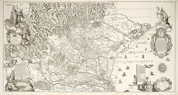
This large map depicts the entire extent of the Diocese of Padua and the surrounding territories, with a detailed topographical rendering. It features rich Baroque ornamentation, including religious figures, finely engraved title and dedication cartouches, allegorical scenes, ships animating the Gulf of Venice, and an elegant compass rose.
Euros 6250
Paolo Bartolomeo Clarici (1664–1725) was trained in Rome in the liberal arts and divine sciences before settling in Padua as a merchant.
Throughout his time there, he pursued mapmaking and botanical studies. His relationship with Cardinal and Bishop of Padua Giorgio Corner led to his ordination at age 53, after which, in 1720, he produced the map of the Diocese of Padua. The following year, he created the topography of Polesine and Rovigo for Doge Giovanni II Corner. Near the end of his life, Clarici moved to Udine with Federico Corner, the lieutenant of Friuli, where he joined the Accademia degli Sventati and wrote several historical and geographical works. Only a geographical table of all the roads and districts leading from the Venetian Dominion to Germany was printed.
Clarici, son of Antongirolamo and Michelangela de' Vignai, left his hometown early and settled in Rome, where he studied liberal arts and theology at the Collegio Nazareno. At age twenty-three, he moved to Padua, earned a living as a merchant, and continued his passion for study and mapmaking. His interest in botany grew, likely fostered by Padua's renowned botanical garden.
In his later years, Clarici gained favor with Cardinal Corner, who ordained him a priest at age fifty-three. In 1720, Corner commissioned him to create a map of the Diocese of Padua; the next year, Doge Giovanni II Corner requested a topographical survey of the Polesine and Rovigo. The 1720 map was well received, according to a 1722 article in the Giornale de’ letterati. Clarici also painted two works for the cardinal’s audience hall. He then worked for the Procurator of St. Mark’s, Gerardo Sagredo, who commissioned botanical studies from him.
Toward the end of his life, Clarici moved to Udine in the retinue of Federico Corner, lieutenant of Friuli. There, he joined the Accademia degli Sventati and wrote historical and geographical works, which were unpublished except for a printed map of roads and districts in the Venetian Dominion and Germany, addressed to the Venetian ambassador to the emperor.
Clarici’s, principal work is Istoria e coltura delle piante che sono pe'l fiore più ragguardevoli, e più distinte per ornare un giardino in tutto il tempo dell'anno, published posthumously in 1726 by his brother Domenico Maria. This volume, the result of Clarici’s botanical research, is divided into four parts: the structure and history of the garden, cultivation techniques, plant history, and citrus fruits.
Among its contents is an engraving of the demolished Villa Sagredo in Morocco, depicting the Italian garden curated by Clarici.
