Browse Listings in Polar maps

Polus Arcticus cum vicinis regionibus.
Map of the North Pole regions from the 1608 second edition of Jodocus Hondius' Atlas Minor.A reduction of the 1606 Mercator-Hondius folio map (which is a later state of t...
Date: Amsterdam, 1608

Poli Arctici, et circumiacentium terrarum descriptio novissima. . .
A re-issue of the Hondius' plate. A particularly decorative map of the North Pole with Iceland. Several Dutch names in Labrador. The toponymy in Canada reflects the conti...
Date: Amsterdam, 1660
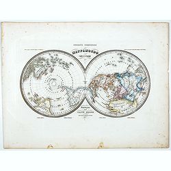
Mappamondo Carta d'Insieme.
Uncommon double hemisphere pole projection prepared by Francesco Costantino Marmocchi. Above the map "Geografia Commerciale". With a color code underneath the m...
Date: Genova, Paolo Rivara fu Giacomo, 1858

Région arctique.
Decorative map of the North Pole, prepared by Louis Vivien de Saint-Martin (* 22. Mai 1802 in Saint-Martin de Fontenay, died 3 January 1897 in Paris). He was one of the m...
Date: Paris, Hachette, 1877
