Browse Listings
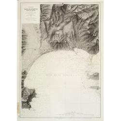
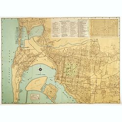
Mer Méditerranée - Côte de France - Golfe de la Napoule Rade de Cannes. . .
Large centered on the Gulf of La Napoule with the harbour of Cannes, the islands Sainte Marguerite and Saint Honorat on the right side. Showing towns, buildings, banks, ...
Date: Paris, 1903 updated 1931
Selling price: ????
Please login to see price!
Sold
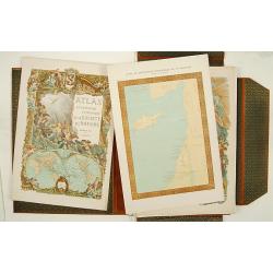
Atlas de géographie economique de la Paléstine.
Impressive atlas including historical, geographical and economical maps of Israel from the earliest time. The 135 maps are printed in color. One of the 3 title pages with...
Date: Paris 1932
Selling price: ????
Please login to see price!
Sold
![Mer Adriatique. Environs de Raguse (Dubrovnik). Troisième Feuille. Gravosa-Raguse-Breno.. [278]](/uploads/cache/23474-250x250.jpg)
Mer Adriatique. Environs de Raguse (Dubrovnik). Troisième Feuille. Gravosa-Raguse-Breno.. [278]
Large scale coastal chart showing a stretch of Dalmatian coast centered on Dubrovnik and covering the area from Verbitza as far as Cavtat.With 2 large inset plans illustr...
Date: Paris [1820] 1932
Selling price: ????
Please login to see price!
Sold in 2023

Port of Volendam.
Original water color-design made by Elizabeth Whitney Moffatt and Gratiane de Gardilanne for their famous book The National Costumes of HollandThe background is consistin...
Date: Netherlands / London 1932
Selling price: ????
Please login to see price!
Sold
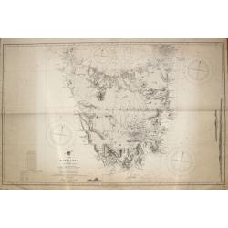
Tasmania formerly Van Diemen Land.
Admiralty chart of Tasmania based on surveys of M.Flinders, P.P.King, J.L.Stokes, Burnett, and James Sprent, published in 1860 and corrected till 1932.
Date: London, 1860 updated for 1932
Selling price: ????
Please login to see price!
Sold in 2009
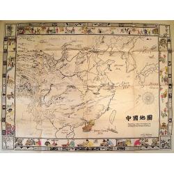
Picture Map of China.
Splendid Art Deco map of China designed to interest and inform children about the country of China. The map is intended to be colored, with the four seasons represented i...
Date: New York, 1932
Selling price: ????
Please login to see price!
Sold in 2010
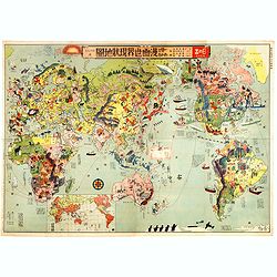
Japanese Stereotype Map of the World from 1932 Share Hitome de wakaru Manga sekai genjō chizu. At a glance: Cartoon Map of the Current World Situation. 目でわかる 漫画世界現状地圖
An extraordinary satirical map of the world was seen through Japanese eyes in the early 1930s as Japanese imperial ambitions strengthened. The map was published as an edi...
Date: Tokyo, Showa 7, or 1932
Selling price: ????
Please login to see price!
Sold in 2016
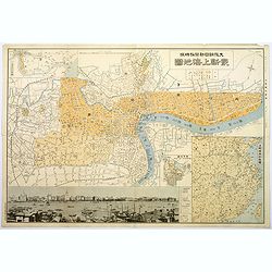
Plan of Shanghai.
A rare plan in Japanese of the Chinese super city of Shanghai, but with individual street names in English. The focus is on central Shanghai and the Bund, the key financi...
Date: Shanghai, 1932
Selling price: ????
Please login to see price!
Sold in 2017
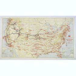
Military Map of the United States / Illustrated Gettysburg Battlefield Map.
The first map of this pair is an attractive general map of the USA Issued by the Union Pacific Railroad during WWII, pictorially showing all the Naval Bases, Army Camps, ...
Date: Chicago, 1942 - Pennsylvannia, 1932
Selling price: ????
Please login to see price!
Sold in 2019
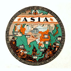
Chart of Knowledge.
This is a rare 1932 double-sided S. G. Bocholtz and Chart of Knowledge spinning wheel map of Asia and Europe. The map of the Asia depicts from Arabia to Japan and from th...
Date: Boston, 1932
Selling price: ????
Please login to see price!
Sold in 2020
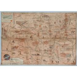
Sante Fe Railway Map - (No Title)
A rare pictorial promotional map published by the Santa Fe Railroad, by B.C. Broome in 1932.The map promotes the lines "Couriercar Indian-detours", stating &quo...
Date: Sante Fe, 1932
Selling price: ????
Please login to see price!
Sold in 2019
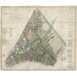
Map of the City of New York with the Latest Improvements
A very fine example of an early edition of Phelps's pocket map of New York City. Dated 1832, this antique map of New York City is one of only a few known examples from th...
Date: New York, 1932
Selling price: ????
Please login to see price!
Sold in 2023

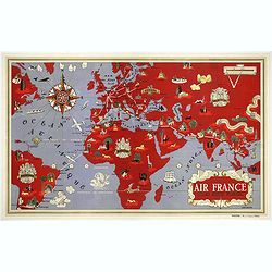
Near East - Far East.
AIR FRANCE poster promoting the airline's routes to the far east in the immediate post-war period. This is the full size version of Lucien Boucher's "phoenix" d...
Date: Imprimerie Perceval Paris, ca. 1933
Selling price: ????
Please login to see price!
Sold in 2019
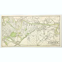
Plan of the Concessions Tientsin.
This plan was drawn for Crow's "Handbook for China" in 1933. It depicts a city map or plan of the foreign concessions in Tianjin (Tientsin), China. The map is b...
Date: Hong Kong, Shanghai, Singapore, 1933
Selling price: ????
Please login to see price!
Sold in 2020

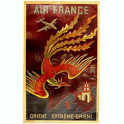
Orient Extreme-Orient.
AIR FRANCE poster promoting the airline's routes to the far east in the immediate post-war period. This is the full size version of Lucien Boucher's ''phoenix'' design. &...
Date: Imprimerie Perceval Paris, ca. 1933
Selling price: ????
Please login to see price!
Sold in 2020
The Stock Exchange London 1933.
A beautiful and whimsical map, chock full of delightful small caricature vignettes, humorously depicting the 'goings on' in the financial market in London's City of Londo...
Date: London=, 1933
Selling price: ????
Please login to see price!
Sold in 2022
Iconographie van Antwerpen.
Important and monumental work on Antwerp! Folio sized plates and maps, loosely inserted in original plain wrappers with printed descriptions. Inside a contemporary half b...
Date: Antwerp, 1933
Selling price: ????
Please login to see price!
Sold in 2013
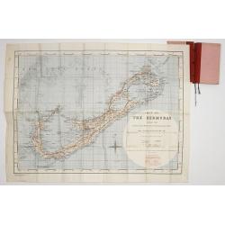
Map of the Bermudas. Compiled from Ordnance Survey Map of 1902, & Admiralty Chart. (1900) Geographical Section. General. Staff. No.3951. Fridded and Railways added 1933. . .
A scarce map of the Bermuda's, compiled from Ordnance Survey Map of 1902, with red grid system and railways added 1933. Scale two inches to one Statute Mile.
Date: London, War Office. 1933
Selling price: ????
Please login to see price!
Sold in 2017
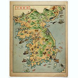
Korea.
Decorative color printed map of Korea in Manga style. From Nihon Manshu Panorama Chiri (Panoramic Geography of Japan and Manchuria) by Ryushiro Kato (map design and text)...
Date: Dai Nihon Yubenkai Kodan Sha, Japan, 1933
Selling price: ????
Please login to see price!
Sold in 2017
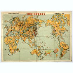
Youth Club Japanese Pictorial map of the world.
A remarkable 1933 Japanese issue pictorial map of the world drawn by Keizo Shimada and published by Yasutarou Sato. Centred on the Japanese Empire, which is highlighted i...
Date: Tokyo, Yasutarou Sato, 1933
Selling price: ????
Please login to see price!
Sold in 2019
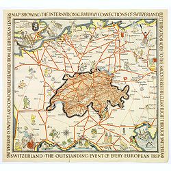
Switzerland The very Heart of Europe / and her International Railway Connections.
A fun map of a centrally positioned Switzerland, mapped in some detail, surrounded by all her many connecting train routes with her neighboring countries. Cities outside ...
Date: Zurich, 1933
Selling price: ????
Please login to see price!
Sold in 2018
Near East - Far East.
AIR FRANCE poster promoting the airline's routes to the far east in the immediate post-war period. This is the full size version of Lucient Boucher's ''phoenix'' design. ...
Date: Imprimerie Perceval Paris, ca. 1933
Selling price: ????
Please login to see price!
Sold in 2018
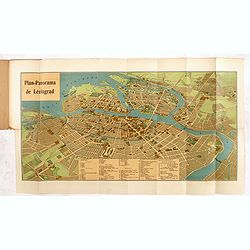
Plan-Panorama de Léningrad.
Official Intourist booklet with a panoramic plan of St. Petersburg printed in chromo-lithography, folded and kept in beige wrapper with title "PLAN-PANORAMA DE LENIN...
Date: Russia, 1931-1934
Selling price: ????
Please login to see price!
Sold in 2014
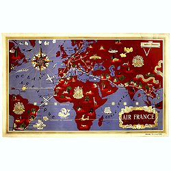
World map
First Air France poster illustrated by Lucien Boucher, printed by Perceval in 1934, only a year after the Air France opening.Shows the world in purple and red depicts rou...
Date: Imprimerie Perceval Paris, ca. 1934
Selling price: ????
Please login to see price!
Sold in 2018
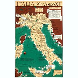
Italia, 1934, Anno XII.
A satirical look at Italy, taken from an American viewpoint, whilst it under a Fascist regime. The text describes cities and regions and directly expresses the author’s...
Date: [United States], 1934
Selling price: ????
Please login to see price!
Sold in 2018
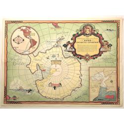
Authorized Map of the Second Byrd Antarctic Expedition.
Offset lithograph color pictorial map of Antarctica and the South Pole by George Annand, printed by General Foods in 1934. The cartouche explains the "notable feat i...
Date: U.S.A., 1934
Selling price: ????
Please login to see price!
Sold in 2020
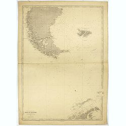
Ocean glacial Antartique - Mers du Cap Horn . . .
Large chart representing the Cap Horn sea, part of Patagonia, Falkland Islands and Palmer Archipelago. A couple of places are highlighted in red.
Date: Paris, 1916 updated to 1934
Selling price: ????
Please login to see price!
Sold in 2022
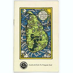
Map of Ceylon showing her Tea Industry.
A delightful little brochure highlighting the Ceylonese tea industry, issued by the Ceylon Tea Propaganda Board in the mid 1930s. It features a lovely map of the island o...
Date: Ceylon, ca 1934
Selling price: ????
Please login to see price!
Sold in 2020
![[ Original Chinese advertising poster for a Manchuria cigarette brand.]](/uploads/cache/45064-250x250.jpg)
[ Original Chinese advertising poster for a Manchuria cigarette brand.]
This poster, an advertisement for Manchuria cigarettes brand from the 1930s, it depicts a nice woman smoking.It shows the rise of Western type advertising during the econ...
Date: Shanghai, 1934
Selling price: ????
Please login to see price!
Sold in 2020
![[Original Chinese advertising poster for a cigarette brand.]](/uploads/cache/45065-250x250.jpg)
[Original Chinese advertising poster for a cigarette brand.]
This poster, an advertisement for Manchou Tobacco Co., LTD cigarettes brand from the 1930s. It depicts a pretty woman posing.It shows the rise of Western type advertising...
Date: Shanghai, 1934
Selling price: ????
Please login to see price!
Sold in 2020
![[Original Chinese advertising poster for a cigarette brand.] Gold Bar / Hatamen](/uploads/cache/45067-250x250.jpg)
[Original Chinese advertising poster for a cigarette brand.] Gold Bar / Hatamen
This poster is an advertisement for Gold Bar and Hatamen Cigarettes brand from the 1930s. It depicts a beautiful woman posing in a scarf, symbolizing the rise of Western-...
Date: Shanghai, 1934
Selling price: ????
Please login to see price!
Sold in 2020
![[Original Chinese advertising poster for Donggong Business School]](/uploads/cache/45081-250x250.jpg)
[Original Chinese advertising poster for Donggong Business School]
This poster, an advertisement from the 1930s for Donggong Business School depicts a pretty woman holding a beautiful fan and wearing jewelry. It shows the rise of Western...
Date: Shanghai, 1934
Selling price: ????
Please login to see price!
Sold in 2020
![[ Original Chinese advertising poster for ] E.I Dupont de Neimours & Co., Inc. Wilmington. Del., U.S.A.](/uploads/cache/45084-250x250.jpg)
[ Original Chinese advertising poster for ] E.I Dupont de Neimours & Co., Inc. Wilmington. Del., U.S.A.
This Shanghai art deco advertising poster for Du Pont, depicting a beautiful woman posing and holding a steam with cherry blossom. Google translate: "Bao Sun Lin col...
Date: Shanghai, 1934
Selling price: ????
Please login to see price!
Sold in 2020
![[Original Chinese advertising poster with two young girls playing golf. ]](/uploads/cache/45088-250x250.jpg)
[Original Chinese advertising poster with two young girls playing golf. ]
This poster, an advertisement from the 1930s, depicts two young girls playing golf.It shows the rise of Western type advertising during the economic boom in early 20th ce...
Date: Shanghai, 1934
Selling price: ????
Please login to see price!
Sold in 2021
![[Original Chinese calendar poster ]](/uploads/cache/45089-250x250.jpg)
[Original Chinese calendar poster ]
This calendar poster is an advertisement from the 1930s and depicts two young woman, one smoking and the other one playing flute.It shows the rise of Western type adverti...
Date: Shanghai, 1934
Selling price: ????
Please login to see price!
Sold in 2020
AIR France - Réseau Aérien Mondial
First Air France planisphere made by Boucher, printed by Perceval in 1934, only a year after the Air France opening. Shows the world in purple and red depicts route maps ...
Date: Imprimerie Perceval, Paris, 1934
Selling price: ????
Please login to see price!
Sold in 2020
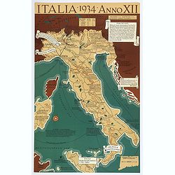
Italia 1934 - Anno XII.
A very satirical map of Italy that heavily criticizes the Fascist regime in the country, with many unflattering notes attached to places and regions. (ie SARDINIA "...
Date: Connecticut, 1934
Selling price: ????
Please login to see price!
Sold in 2021
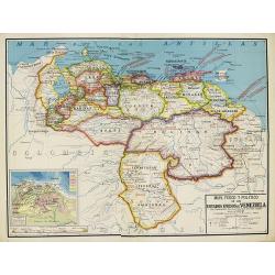
Mapa Fisico y Politico de los Estados Unidos de Venezuela..
Very large fold-out map of Venezuela, including part of Colombia, Brazil and Guyana. With inset front view of the tallest mountains from the Sierra Nevada to Mount Roraim...
Date: Paris, 1934
Selling price: ????
Please login to see price!
Sold in 2019
![Entrée de la Mer Adriatique.. [2662]](/uploads/cache/23488-250x250.jpg)
Entrée de la Mer Adriatique.. [2662]
Large chart centered on the Strait of Otranto and illustrating the Salento peninsula at the Italian side as well as the northwestern coast of Albania and the northwest mo...
Date: Paris [1886] corrected for 1935
Selling price: ????
Please login to see price!
Sold in 2023
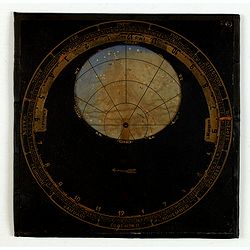
Sterrenkaart voor Nederland door DR. E.A Kreiken.
Movable star chart prepared by Dr E.A. Kreiken (1896-1964) He has studied astronomy in Groningen 1923 and worked in Indonesia.
Date: Amsterdam, W. Versluys, ca. 1935
Selling price: ????
Please login to see price!
Sold in 2015
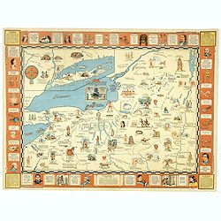
Indian episodes of New York State, land of the Hodenosaunee .
Pictorial map of New York State, illustrated and noted throughout with small vignettes of historic locations and events, landmarks, rivers, Native Americans in various ac...
Date: New York, 1935
Selling price: ????
Please login to see price!
Sold in 2016
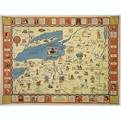
Indian Episodes of New York.
A drama-story map of the Empire State, displaying Indian episodes of New York, a lithograph produced by the Rochester Museum of Arts and Sciences.The map is surrounded by...
Date: Rochester, 1935
Selling price: ????
Please login to see price!
Sold in 2017
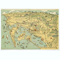
Map of San Diego California City and County.
A lovely folding map of San Diego on one side, and a smaller map of San Diego County on the reverse, together with a comprehensive street index, nice attractive pictorial...
Date: San Diego, ca. 1935
Selling price: ????
Please login to see price!
Sold in 2017
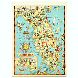
Florida.
Pictorial map of Florida, from the famous illustrator, Ruth Taylor White and published in "Our USA: A Gay Geography".Ruth Taylor White was among the most prolif...
Date: Boston, Little, Brown and Company, 1935
Selling price: ????
Please login to see price!
Sold in 2017
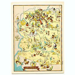
Arizona.
Pictorial map of Arizona, from the famous illustrator, Ruth Taylor White and published in "Our USA: A Gay Geography".Ruth Taylor White was among the most prolif...
Date: Boston, Little, Brown and Company, 1935
Selling price: ????
Please login to see price!
Sold in 2017
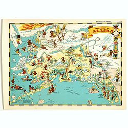
Alaska.
Pictorial map of Alaska, from the famous illustrator, Ruth Taylor White and published in "Our USA: A Gay Geography".Ruth Taylor White was among the most prolifi...
Date: Boston, Little, Brown and Company, 1935
Selling price: ????
Please login to see price!
Sold in 2018
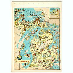
Michigan.
Pictorial map of Michigan, from the famous illustrator, Ruth Taylor White and published in "Our USA: A Gay Geography".Ruth Taylor White was among the most proli...
Date: Boston, Little, Brown and Company, 1935
Selling price: ????
Please login to see price!
Sold in 2018
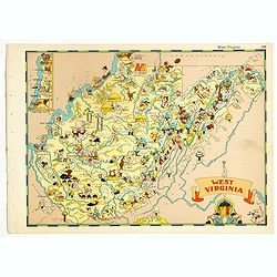
West Virginia.
Pictorial map of West Virginia, from the famous illustrator, Ruth Taylor White and published in "Our USA: A Gay Geography".Ruth Taylor White was among the most ...
Date: Boston, Little, Brown and Company, 1935
Selling price: ????
Please login to see price!
Sold in 2018
Washington.
Pictorial map of Washington, from the famous illustrator, Ruth Taylor White and published in "Our USA: A Gay Geography".Ruth Taylor White was among the most pro...
Date: Boston, Little, Brown and Company, 1935
Selling price: ????
Please login to see price!
Sold in 2019
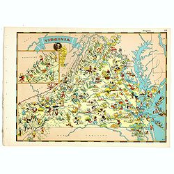
Virginia.
Pictorial map of Virginia, from the famous illustrator, Ruth Taylor White and published in "Our USA: A Gay Geography".Ruth Taylor White was among the most proli...
Date: Boston, Little, Brown and Company, 1935
Selling price: ????
Please login to see price!
Sold in 2018
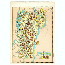
Vermont.
Pictorial map of Vermont, from the famous illustrator, Ruth Taylor White and published in "Our USA: A Gay Geography".Ruth Taylor White was among the most prolif...
Date: Boston, Little, Brown and Company, 1935
Selling price: ????
Please login to see price!
Sold in 2018
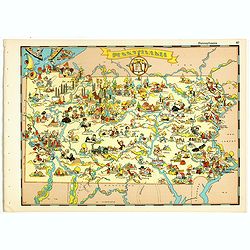
Pennsylvania.
Pictorial map of Pennsylvania, from the famous illustrator, Ruth Taylor White and published in "Our USA: A Gay Geography".Ruth Taylor White was among the most p...
Date: Boston, Little, Brown and Company, 1935
Selling price: ????
Please login to see price!
Sold in 2018
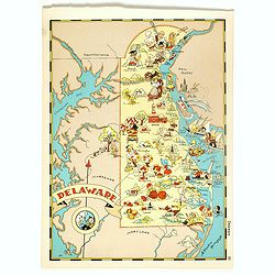
Delaware.
Pictorial map of Delaware, from the famous illustrator, Ruth Taylor White and published in "Our USA: A Gay Geography".Ruth Taylor White was among the most proli...
Date: Boston, Little, Brown and Company, 1935
Selling price: ????
Please login to see price!
Sold in 2018
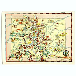
Colorado.
Pictorial map of Colorado, from the famous illustrator, Ruth Taylor White and published in "Our USA: A Gay Geography".Ruth Taylor White was among the most proli...
Date: Boston, Little, Brown and Company, 1935
Selling price: ????
Please login to see price!
Sold in 2017
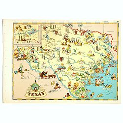
Texas.
Pictorial map of Texas, from the famous illustrator, Ruth Taylor White and published in "Our USA: A Gay Geography".Ruth Taylor White was among the most prolific...
Date: Boston, Little, Brown and Company, 1935
Selling price: ????
Please login to see price!
Sold in 2018
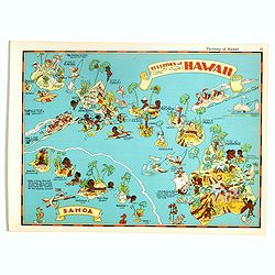
Territory of Hawaii - Samoa.
Pictorial map of Territory of Hawaii - Samoa, from the famous illustrator, Ruth Taylor White and published in "Our USA: A Gay Geography".Ruth Taylor White was a...
Date: Boston, Little, Brown and Company, 1935
Selling price: ????
Please login to see price!
Sold in 2017
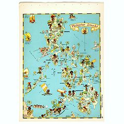
Philippines Islands.
Pictorial map of Philippines Islands, from the famous illustrator, Ruth Taylor White and published in "Our USA: A Gay Geography".Ruth Taylor White was among the...
Date: Boston, Little, Brown and Company, 1935
Selling price: ????
Please login to see price!
Sold in 2017
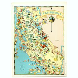
California.
Pictorial map of California, from the famous illustrator, Ruth Taylor White and published in "Our USA: A Gay Geography".Ruth Taylor White was among the most pro...
Date: Boston, Little, Brown and Company, 1935
Selling price: ????
Please login to see price!
Sold in 2017
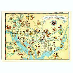
Washington, District of Columbia, the national capital.
Pictorial map of Washington, District of Columbia, the national capital, from the famous illustrator, Ruth Taylor White and published in "Our USA: A Gay Geography&qu...
Date: Boston, Little, Brown and Company, 1935
Selling price: ????
Please login to see price!
Sold in 2017
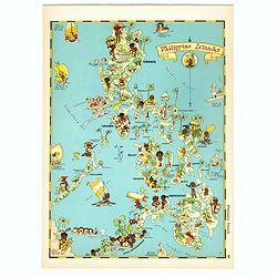
Philippines Islands.
Pictorial map of Philippines Islands, from the famous illustrator, Ruth Taylor White and published in "Our USA: A Gay Geography".Ruth Taylor White was among the...
Date: Boston, Little, Brown and Company, 1935
Selling price: ????
Please login to see price!
Sold in 2018
Map of San Diego California City and County.
A lovely folding recreational map of San Diego City & County, Compiled & Copyrighted by Lowell E. Jones. Map of San Diego on one side, and a smaller map of San Di...
Date: San Diego, ca. 1935
Selling price: ????
Please login to see price!
Sold in 2017

Die Karte Spricht! 30 bunte Bildkarten zur Erdkunde unseres Vaterlandes.
This unusual booklet, with 30 maps printed in attractive crude offset lithograph, were made in Wroclaw (Breslau), today Poland, but in 1930s, a part of Germany and beside...
Date: Breslau, Heinrich Handel, ca. 1935
Selling price: ????
Please login to see price!
Sold in 2018
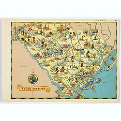
South Carolina.
A fun, humorous, whimsical map of South Carolina by Ruth Taylor White.
Date: Boston, ca 1935
Selling price: ????
Please login to see price!
Sold in 2020
LA CÔTE D'AZUR.
Cover of an illustrated flyer. Printed by E.Imbert & Cie, Grasse -
Date: Grasse, ca. 1935
Selling price: ????
Please login to see price!
Sold in 2020
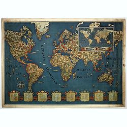
Philips Radio.
This map by Walter Eckhard (1903 - 1982) depicts a Mercator projection of the short waves Philips enabled and could be picked up by their radios. The shields at the botto...
Date: Eindhoven, ca. 1935
Selling price: ????
Please login to see price!
Sold in 2019
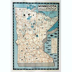
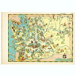
Minnesota invites you to Live-Work-Play in the Playground of 10,000 Lakes.
An attractive three color pictographic map of Minnesota, that folds down to a pamphlet, with numerous color and black and white illustrations on the verso. On the map, sm...
Date: Saint Paul, 1935
Selling price: ????
Please login to see price!
Sold in 2020
Rodi. Rhodes. Rhodos
Pictorial map of Rhodes, the island of the sun or rose island in Greece. Signed by Egon Huber Rodi 1935 on lower right. On upper right: Rodi, Rhodes, Rhodos, Rhodus. Show...
Date: Italty, 1935
Selling price: ????
Please login to see price!
Sold in 2021
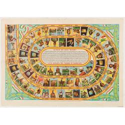
Giuoco dei dadi Nutro. Alla ricerca del tersoro di menelick
Goos-game with 75 numbered boxes, numbered counterclockwise, advertising of the Nutro company. Prepared by L. Ciompi. The boxes starting with the departure of a voyage in...
Date: Milan, Off. Graf.S.Tavella & C., 1936
Selling price: ????
Please login to see price!
Sold in 2020
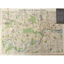
Map of Central London
A highly detailed folding map of Central London, published between the wars.
Date: London, 1936
Selling price: ????
Please login to see price!
Sold in 2016
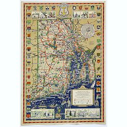
Rhode Island and Providence Plantations. . .
An attractive and uncommon map of the smallest US state of Rhode Island, or officially known as Rhode Island and Providence Plantations. The map is surrounded by a number...
Date: Rhode Island, 1936
Selling price: ????
Please login to see price!
Sold in 2017
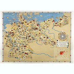
L'Allemagne au paradis du tourisme.
Iconographic map of Germany designed by Walter Riemer, published during pre world war II, by Reichsbahnzentrale. This propaganda paper was published in preparation for th...
Date: Berlin, 1936
Selling price: ????
Please login to see price!
Sold in 2017
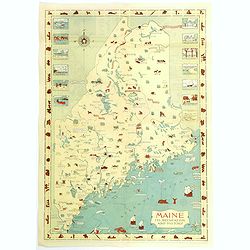
Maine. Its Recreation and History.
A pictorial map of the American state of Maine. This large map is littered with small icons and vignettes as to the various activities that can be had within the state, e...
Date: Augusta, ca. 1936
Selling price: ????
Please login to see price!
Sold in 2018
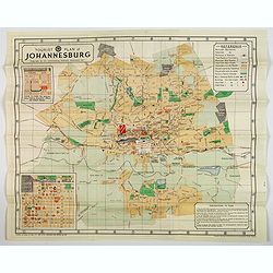
Tourist Plan of Johannesburg.
A lovely color map in brochure form of Johannesburg, with a pair of inset plans one is 'HOW TO FIND The Johannesburg Publicity Association Offices and Visitors Bureau' &a...
Date: Pretoria, 1936
Selling price: ????
Please login to see price!
Sold in 2020

New Map of Cairo and Environs.
A nice, decorative city plan of Cairo in stiff grey printed card wrappers, with a comprehensive index of Clubs, Hospitals, Churches, Government Offices and General Points...
Date: Alexandria, ca 1936
Selling price: ????
Please login to see price!
Sold in 2020

Historical map of Florida showing points of interest to visitors.
Historical map of Florida showing points of interest to visitors, issued by Florida State Department of Agriculture, in 1937 under the commission of Nathan Mayo and T.J.B...
Date: Jacksonville, the Drew Press, 1937
Selling price: ????
Please login to see price!
Sold in 2012
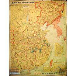
Grand Map of Eastern China and Manchukuo.
Spectacular scroll map of eastern China and the puppet state of Manchukuo. Published by the Tokyo Electric Company Limited (Tōkyō Denki Kabushiki Kaisha...
Date: Tokyo, 1937
Selling price: ????
Please login to see price!
Sold in 2012
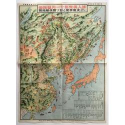
Hitome de wakaru Shina jihen to Nisso kankei echizu - Map of East Asia and Soviet, detailing the development of the Sino-Japanese Conflict
The main map includes numerous pictorial features of people in each country and region on the map. Names of major cities are given, and several charts, such as a chronolo...
Date: Japan, 1937
Selling price: ????
Please login to see price!
Sold in 2016

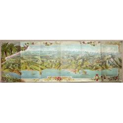
Chateau Gaillard Normandy.
Etching of a landscape on the banks of the Seine-river, with Chateau Gaillard at les Andelys.Signed with pencil by the artist at bottom right.
Date: England c. 1937
Selling price: ????
Please login to see price!
Sold
![Chousen Annai [Guide to Korea].](/uploads/cache/99672-250x250.jpg)
Chousen Annai [Guide to Korea].
6-panel tourist brochure featuring a lovely full-color bird’s-eye view of the Korean peninsula supplemented by copious text in Japanese and Korean about the country. Th...
Date: Tokyo, 1937
Selling price: ????
Please login to see price!
Sold in 2010
![[Map of the Current Situation in East Asia].](/uploads/cache/99679-250x250.jpg)
[Map of the Current Situation in East Asia].
Uncommon ephemeral map showing areas occupied by the Japanese, Chinese, and Soviet in the Far East at the outbreak of the Second World War. A tank-shaped insert provides ...
Date: Osaka, 1937
Selling price: ????
Please login to see price!
Sold in 2010