Browse Listings
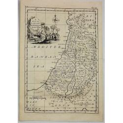
A Map of Canaan Divided Among the Twelve Tribes.
An Old Testament Israel showing its twelve divisions according to the tribes. With a decorative title cartouche depicting the Ark of the Covenant, various temple tools an...
Date: London, 1756
Selling price: ????
Please login to see price!
Sold in 2019
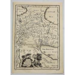
A Map of the Terrestrial Paradise According to Mr. Huet with Improvements from Dr. Wells.
A map of the Ancient Near East, showing ancient cities, kingdoms, and pinpointing the site of the Garden of Eden. With a decorative title cartouche featuring Eden and Ada...
Date: London, 1756
Selling price: ????
Please login to see price!
Sold in 2020
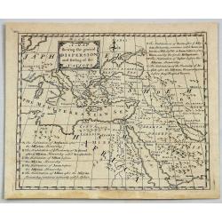
A Map Shewing the General Dispersion and Settling of the Nations.
A fine map of The Eastern Mediterranean, Arabia and part of North Africa, illustrating the area that was settled by the three sons of Noah (Sem, Ham & Japeth) after t...
Date: London, 1756
Selling price: ????
Please login to see price!
Sold in 2021
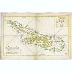
Carte de L'Isle de Madagascar. . .
A beautiful, large and quite detailed chart of the African island of Madagascar by Jacques Nicolas Bellin. The interior of the island is littered with forests, mountains,...
Date: Paris, ca 1756
Selling price: ????
Please login to see price!
Sold in 2018
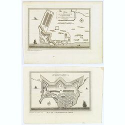
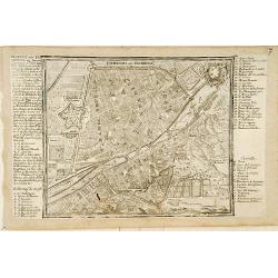
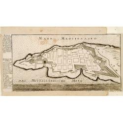
Plan de la Forteresse de Coylan / Plan de la Forteresse de Cranganor. . .
The first of a pair of Indian prints is a rare map of the fort of Kollam, Kerala, on India's (east) Malabar Coast by the French cartographer N. Bellin. Kollam, or as it i...
Date: Paris, ca 1756
Selling price: ????
Please login to see price!
Sold in 2019
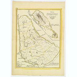
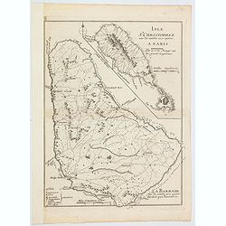
L'Isle St. Christophle. . . La Barbade. . .
Two maps on one sheet showing Barbados and St. Christophers. Physical map detail is depicted rather than topographical information. A few place names, capes and bays are ...
Date: Paris, 1756
Selling price: ????
Please login to see price!
Sold in 2019
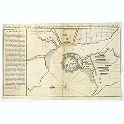
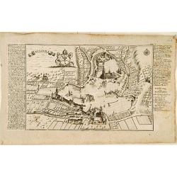
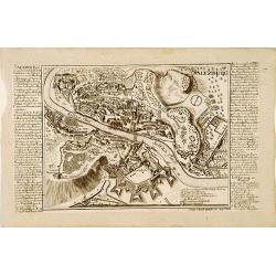
A Plan of the Town & Fortress of Garlah belonging to Angria the Admiral to the Jahou Rajah on the Coast of Mallabar.
A very interesting bird's eye view of the fort and surrounds. Text at left explains the numbers on the chart providing fascinating detail. With rhumb lines, soundings, a ...
Date: London, 1756
Selling price: ????
Please login to see price!
Sold in 2021
Atlas nouveau portatif à l'usage des militaires et du voyageur.
>Charming atlas with an engraved title, and 91 numbered and engraved double-page maps in orginal out line colors. The atlas starts by 36 pages text entitled 'Introduct...
Date: Paris, Le Rouge, Prault, Veuve Robinot, Briasson, 1756
Selling price: ????
Please login to see price!
Sold in 2022

Histoire Naturelle, Phoques.
An interesting plate showing four types of seal. Probably from a work by Diderot named Encyclopedia oder Dictionnaire raisonne des sciences, des arts et des metiers.
Date: Paris, ca 1756
Selling price: ????
Please login to see price!
Sold in 2019
![[4 sheets] LA EUROPA Dividida en sus principales Estados / EL AFRICA Dividida en todos sus principales Reynos / EL ASIA Co toda la Extension de sus Reinos y Provincias. . .](/uploads/cache/83544-250x250.jpg)
[4 sheets] LA EUROPA Dividida en sus principales Estados / EL AFRICA Dividida en todos sus principales Reynos / EL ASIA Co toda la Extension de sus Reinos y Provincias. . .
This is a rare spanish FOUR CONTINENTS MAP SET of Europe, Africa, Asia and America made by Pedro Gendron - the titles can be roughly translated as - ". . .divided in...
Date: Madrid, after 1756
Selling price: ????
Please login to see price!
Sold in 2021
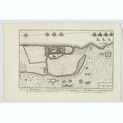
Plan de Madraz et du Fort St. Georges. Pris par les Francois le 21 Septembre 1746 / Grondtekening van Madras en't Fort St. Georges, door de Fransen ingenoomen den 21 September 1746.
A plan of the city of Chennai (then Madras) the capital of Tamil Nadu, in southern India, and the old British Fort of St George (captured during the brief French occupati...
Date: Amsterdam, ca 1756
Selling price: ????
Please login to see price!
Sold in 2021
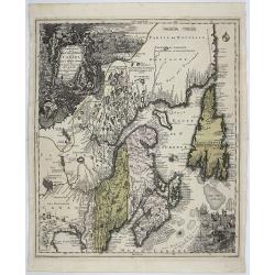
Partie Orientale de la Nouvelle France ou du Canada. . .
A remarkably detailed map of North Eastern Canada, including Nova Scotia, Newfoundland and Labrador. The vertical projection shows the St. Lawrence River running nearly n...
Date: Augsburg, 1756
Selling price: ????
Please login to see price!
Sold in 2021
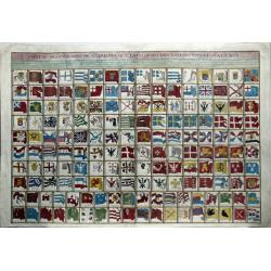
Tableau Des Pavillons ou Bannieres Que La Pluspart Des Nations Arborent a la Mer.
A large engraved plate with over 160 different National and Maritime Flags which appeared in Bellin's L'Hydrographie Francois. The map includes a remarkable array of nati...
Date: Paris, 1756
Selling price: ????
Please login to see price!
Sold in 2020
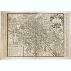
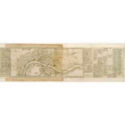
Plan de Paris divisé en seize quartiers. . .
Large decorative plan with lettered key to the streets, parishes, colleges, hospitals and communities. The end of the address has been erased, state not cited by Vallée.
Date: Paris, 1756
Selling price: ????
Please login to see price!
Sold in 2021
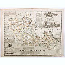
An Accurate Map of Berkshire divided into its Hundreds . . .
A good clean copy of by far the most important eighteenth-century English atlas to be published before the appearance of John Cary's new English atlas in 1787 (Hodson). T...
Date: London ca 1756
Selling price: ????
Please login to see price!
Sold in 2023
![[Title page Atlas Maior Cvm Generales Omnivm Totivs Orbis]](/uploads/cache/47721-250x250.jpg)
[Title page Atlas Maior Cvm Generales Omnivm Totivs Orbis]
Title page for an atlas by Reiner Ottens titled Atlas Maior Cvm Generales Omnivm Totivs Orbis, published in Amsterdam, 1756. The figures represent, from the top and clock...
Date: Amsterdam, 1756
Selling price: ????
Please login to see price!
Sold in 2021
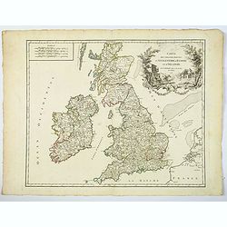
Carte des Grandes Routes d'Angleterre, d'Ecosse, et d'Irlande.
This is a delightful 1757 map of the British Isles by Robert de Vaugondy. The map extent is all of England, Wales, Scotland and Ireland, and it notes several important ro...
Date: London, 1757
Selling price: ????
Please login to see price!
Sold in 2021
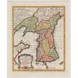
Carte de la province de Quan-tong, ou Lyau-tong et du Royaume de Kau-li. . .
Map of Korea. The map is of interest for the use of East Sea, the sea between Korea and Japan, here called "Mer de Corée".Decorative title cartouche in lower l...
Date: Paris, 1757
Selling price: ????
Please login to see price!
Sold in 2021
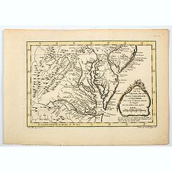
Carte de la Virginie, de la Baye Chesapeack, et Pays Voisins.
An attractive and detailed map of the Chesapeake, Virginia, Maryland, Delaware, just before the settlement between Penn and Lord Baltimore, with Delaware properly shown a...
Date: Paris, 1757
Selling price: ????
Please login to see price!
Sold in 2020
Isle St. Christophle. . ../ La Barbade. . .
Two maps on one sheet: top - St.Christopher and bottom - Barbados. George Louis Le Rouge was active from 1740 until 1780 as a publisher, and was appointed engineer for th...
Date: Paris, 1757
Selling price: ????
Please login to see price!
Sold in 2020
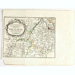
Tavola topografica che rappresenta le vicinanze di breslavia.
Detailed map showing the area west of Wroclaw, large title cartouche in upper left corner.
Date: Italy, ca. 1757
Selling price: ????
Please login to see price!
Sold in 2020
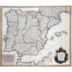
LOS REYNOS DE ESPANA Y PORTUGAL...
A nice example of Gendron's map of the Iberian Peninsula. As most 18th Century maps published in Spain, which are based upon non-Spanish sources, are based upon French so...
Date: Madrid, 1757
Selling price: ????
Please login to see price!
Sold in 2021
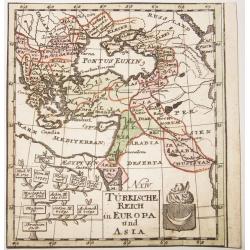
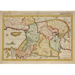
TURKISCHE REICH in EUROPA und ASIA.
A rare copper engraved map of the Ottoman Empire in Europe and Asia. Contains in a lower quadrant the coats of arms of the Empire, and a genealogical tree of the rulers ,...
Date: Berlin, ca 1757
Selling price: ????
Please login to see price!
Sold in 2021
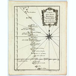
Carte des Isles Maldives.
A small detailed map of the Maldives, with rhumb lines and a large compass rose. Includes a decorative title cartouche. One of the maps produced by Nichlas Bellin for Pre...
Date: Paris, 1757
Selling price: ????
Please login to see price!
Sold in 2021
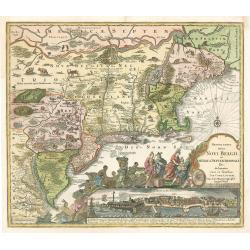
Recens Edita totius Belgii, in America
Arguably one of the most recognizable maps of the Northeastern American colonies this fifth state example of Novi Belgii by Tobias Conrad Lotter series does not disappoin...
Date: Augsburg, Germany 1757
Selling price: ????
Please login to see price!
Sold in 2023
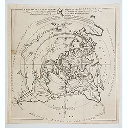
A Physical Planisphere wherein are represented all the known Lands and Seas with the Great Chain of Mountains. . . and Seas in the Great Chains of Mountains. . .
This is an elegant 1757 map of the world represented on an unusual polar projection rendered from the North Pole. The map covers from the North Pole Arctic region south b...
Date: London, 1757
Selling price: ????
Please login to see price!
Sold in 2023

Carte de la province de Quan-tong, ou Lyau-tong et du Royaume de Kau-li. . .
Map of Korea. The map is of interest for the use of East Sea, the sea between Korea and Japan, here called "Mer de Corée" and "Meer von Korea".From a...
Date: Paris, 1757
Selling price: ????
Please login to see price!
Sold in 2023
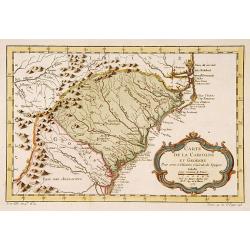
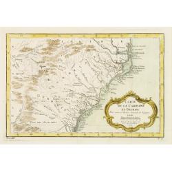
Carte de la Caroline et Georgie..
Jaques Nicolaas Bellin (1703-1772) was one of the most important and proficient French cartographers of the mid-eighteenth century. He was appointed the first Ingenieur H...
Date: Paris 1757
Selling price: ????
Please login to see price!
Sold
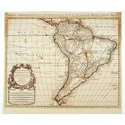
L'Amerique Meridionale Dressée sur les Observations
Detailed map of South America prepared by De L'Isle, with fine title cartouche.
Date: Amsterdam 1757
Selling price: ????
Please login to see price!
Sold
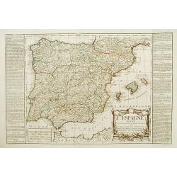
L'Espagne divisée en ses Royaumes et .. avac le Royaumes de Portugal.
RARE map of Spain and Portugal prepared by J.B.Nolin and published by Daumont. A visually stunning map with a large title cartouche. To the left and right text boxes with...
Date: Paris 1757
Selling price: ????
Please login to see price!
Sold
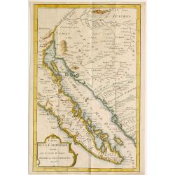
Carte de la Californie, Levée par la Société des Jesuites..
Uncommon updated version of Father Kino's epoch-making map of 1705 which was finally to decide De L'Isle as to California being a peninsula and, through him, to influence...
Date: Paris, after 1757
Selling price: ????
Please login to see price!
Sold
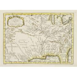
Carte de la Louisiane et pays Voisins.
Accurate map showing the lower Mississippi River and surrounding areas, the ranges and villages of numerous Indian tribes are shown.Jacques Nicolas Bellin (1703-1772) was...
Date: Paris, 1757
Selling price: ????
Please login to see price!
Sold in 2011

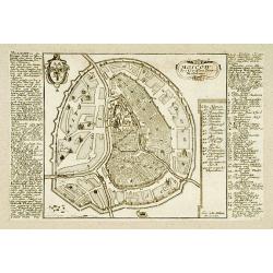
Lucca.
Very rare bird's-eye plan of Lucca. To the sides a historical description and a numbered key.George Christophe Kilian (1709-1780) active as engraver of Augsburg published...
Date: Augsburg 1757
Selling price: ????
Please login to see price!
Sold
Lausanna.
Very rare bird's-eye plan of Lausanne. To the sides a historical description and a lettered key.George Christophe Kilian (1709-1780) active as engraver of Augsburg publis...
Date: Augsburg 1757
Selling price: ????
Please login to see price!
Sold
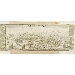
Londen.
Very rare bird's-eye plan of London. To the sides a historical description and a numbered key.George Christophe Kilian (1709-1780) active as engraver of Augsburg publishe...
Date: Augsburg 1757
Selling price: ????
Please login to see price!
Sold
Genua oder Genova.
Very rare bird's-eye plan of Genova. To the sides a historical description and a numbered key.George Christophe Kilian (1709-1780) active as engraver of Augsburg publishe...
Date: Augsburg 1757
Selling price: ????
Please login to see price!
Sold
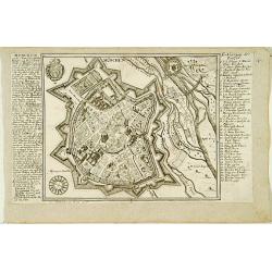
![Plan Alt und Neuer Fortificatizon von Malta gelegen auf der Insul gleiches Namens. [Valletta]](/uploads/cache/17369-250x250.jpg)
Plan Alt und Neuer Fortificatizon von Malta gelegen auf der Insul gleiches Namens. [Valletta]
Very rare bird's-eye plan of town and harbor of Valletta on Malta. To the sides a historical description and a numbered key.George Christophe Kilian (1709-1780) active as...
Date: Augsburg 1757
Selling price: ????
Please login to see price!
Sold
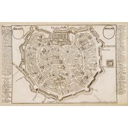
Milano - Meyland.
Very rare bird's-eye plan of Milan. To the sides a historical description and a numbered key.George Christophe Kilian (1709-1780) active as engraver of Augsburg published...
Date: Augsburg 1757
Selling price: ????
Please login to see price!
Sold
Moscow.
Very rare bird\'s-eye plan of Moscow. To the sides a historical description and a numbered key.George Christophe Kilian (1709-1780) active as engraver of Augsburg publish...
Date: Augsburg 1757
Selling price: ????
Please login to see price!
Sold
München.
Very rare bird's-eye plan of Munich. To the sides a historical description and a numbered key.George Christophe Kilian (1709-1780) active as engraver of Augsburg publishe...
Date: Augsburg 1757
Selling price: ????
Please login to see price!
Sold
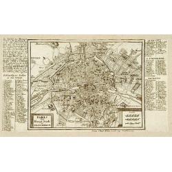
Paris.
Very rare bird's-eye plan of Paris. To the sides a historical description and a numbered key.George Christophe Kilian (1709-1780) active as engraver of Augsburg published...
Date: Augsburg 1757
Selling price: ????
Please login to see price!
Sold
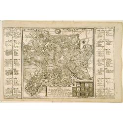
Roma.
Very rare bird's-eye plan of Rome. To the sides a historical description and a numbered key.George Christophe Kilian (1709-1780) active as engraver of Augsburg published ...
Date: Augsburg 1757
Selling price: ????
Please login to see price!
Sold
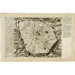
Bologna.
Very rare bird's-eye plan of Bologna. To the sides a historical description and a numbered key.George Christophe Kilian (1709-1780) active as engraver of Augsburg publish...
Date: Augsburg 1757
Selling price: ????
Please login to see price!
Sold
Fiorenza oder Florenz.
Very rare bird's-eye plan of Florence. To the sides a historical description and a numbered and lettered key.George Christophe Kilian (1709-1780) active as engraver of Au...
Date: Augsburg 1757
Selling price: ????
Please login to see price!
Sold
Saltzburg.
Very rare bird's-eye plan of Salzburg. To the sides a historical description and a numbered key.George Christophe Kilian (1709-1780) active as engraver of Augsburg publis...
Date: Augsburg 1757
Selling price: ????
Please login to see price!
Sold
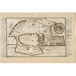
Stutgart.
Very rare bird's-eye plan of Stuttgart. To the sides a historical description and a numbered key.George Christophe Kilian (1709-1780) active as engraver of Augsburg publi...
Date: Augsburg 1757
Selling price: ????
Please login to see price!
Sold
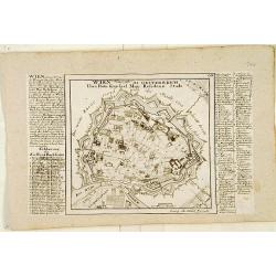
Wien.
Very rare bird's-eye plan of Vienna. To the sides a historical description and a numbered and lettered key.George Christophe Kilian (1709-1780) active as engraver of Augs...
Date: Augsburg 1757
Selling price: ????
Please login to see price!
Sold
![Cölln. [Cologne]](/uploads/cache/17380-250x250.jpg)
Cölln. [Cologne]
Very rare bird's-eye plan of Cologne. To the sides a historical description and a numbered key.George Christophe Kilian (1709-1780) active as engraver of Augsburg publish...
Date: Augsburg 1757
Selling price: ????
Please login to see price!
Sold
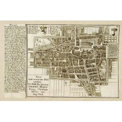
Haag.
Very rare bird's-eye plan of Den Haag. To the left side a historical description.George Christophe Kilian (1709-1780) active as engraver of Augsburg published his Kleiner...
Date: Augsburg 1757
Selling price: ????
Please login to see price!
Sold
Malta ad Vallette.
Very rare bird's-eye plan of Valetta. To the left side a historical description and a lettered key.George Christophe Kilian (1709-1780) active as engraver of Augsburg pub...
Date: Augsburg 1757
Selling price: ????
Please login to see price!
Sold
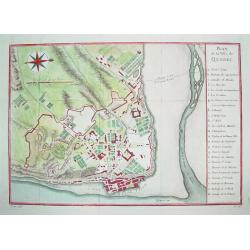
Plan de la Ville de Quebec.
A beautifully engraved mid-18th century plan of Quebec. The work contains a 24 point legend which identifies key sites and places of interest. Enhanced with a compass ros...
Date: Paris, c. 1757
Selling price: ????
Please login to see price!
Sold
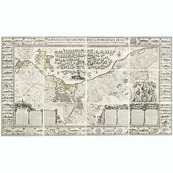
Nova illustrissimi principatus Pomeraniae descrptio.. .
"Only a small number of copies were printed and so this edition is a very rare object today" (Scharfe). THE MOST IMPORTANT EARLY MAP OF POMERANIA, the region on...
Date: Amsterdam, 1618-1757
Selling price: ????
Please login to see price!
Sold in 2015
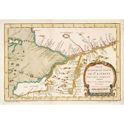
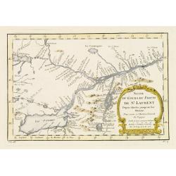
Suite du Cours du Fleuve de St.Laurent depuis Quebec jusqu' au Lac Ontario.
A map of Prevost's 'Hist. des Voyages', depicting the cours of the St. Lawrence river from lake Onario to Quebec.Jaques Nicolaas Bellin (1703-1772) was one of the most im...
Date: Paris, 1757
Selling price: ????
Please login to see price!
Sold
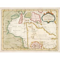
Carte de la Baye de Hudson..
Jacques Nicholas Bellin (1703-1772) was one of the most important and proficient French cartographers of the mid-eighteenth century. He was appointed the first Ingenieur ...
Date: Paris, 1757
Selling price: ????
Please login to see price!
Sold
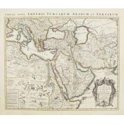
TURKEY AND ARABIA
Large map of the Middle-East, showing the Arabian peninsula, Turkey, Persia, Greece, Italy and a large part of north-eastern Africa. Originally designed and edited by de ...
Date: Amsterdam, 1757
Selling price: ????
Please login to see price!
Sold
Suite du Cours du Fleuve de St.Laurent..Ontario.
A map of Prevost's 'Hist. des Voyages', depicting the course of the St. Lawrence river from lake Ontario to Quebec.Jacques Nicolas Bellin (1703-1772) was one of the most ...
Date: Paris 1757
Selling price: ????
Please login to see price!
Sold
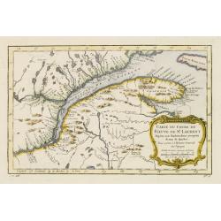
Carte du Cours du Fleuve de St.Laurent..Quebec.
A map of Prevost's 'Hist. des Voyages', depicting the course of the St. Lawrence river from Quebec to the Atlantic.Jacques Nicolas Bellin (1703-1772) was one of the most ...
Date: Paris 1757
Selling price: ????
Please login to see price!
Sold
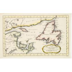
Carte du Golphe de St.Laurent et Pays Voisins..
Accurate map depicting the gulf of St. Lawrence and the surrounding area, included the isle of Newfoundland.Jacques Nicolaas Bellin (1703-1772) was one of the most import...
Date: Paris 1757
Selling price: ????
Please login to see price!
Sold
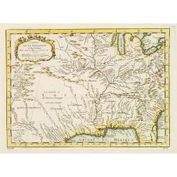
Carte de la Louisiane et pays Voisins.
Accurate map showing the lower Mississippi River and surrounding areas, the ranges and villages of numerous Indian tribes are shown.Jacques Nicolaas Bellin (1703-1772) wa...
Date: Paris 1757
Selling price: ????
Please login to see price!
Sold
Carte de la Caroline et Georgie..
Accurate map depicting the eastern coast of the United States from Savannah to Edenton as well as the inland corresponding to today Carolinas. Includes part of Georgia.Ja...
Date: Paris 1757
Selling price: ????
Please login to see price!
Sold
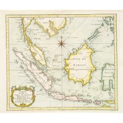
Carte des Isles de Java Sumatra et Borneo..
A very fine map centered on the islands of Java, Sumatra, Borneo and Malay Peninsular.Jacques Nicolaas Bellin (1703-1772) was one of the most important and proficient Fre...
Date: Paris 1757
Selling price: ????
Please login to see price!
Sold
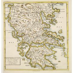
Oud Griekenland zo als 't eerste in Koninkrijken..
Very unusual map of ancient Greece. In upper left margin V. Deel Bladz.275.
Date: Utrecht c.1757
Selling price: ????
Please login to see price!
Sold
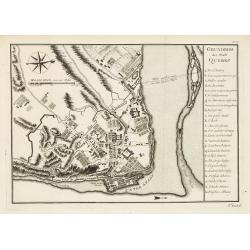
Grundriss der Stadt Quebec.
Plan of Quebec with table of explanations to the right side. From a German edition of Prevost's 'Hist. des Voyages'. Jacques Nicolaas Bellin (1703-1772) was one of the mo...
Date: Paris 1757
Selling price: ????
Please login to see price!
Sold
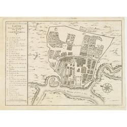
Plan de la ville de Louvo Demeure ordinaire des Rois de Siam.
From Prevost\'s Histoire des Voyages. Jacques Nicolas Bellin (1703-1772) was one of the most important and proficient French cartographers of the mid-eighteenth century. ...
Date: Paris, 1757
Selling price: ????
Please login to see price!
Sold in 2008
De Gelegenheyt van 't Paradys en 't Landt Canaan, mitsgaders d, eerste bewoonde landen der Patriarchen?door C.D./Albert Schut Schulp.
Dutch so-called ' Staten' bibles, published between 1637 and c. 1760, contained 5 maps: The World, 'Paradise', The Perigrinations, The Promised Land Canaan, The Travels o...
Date: Amsterdam / Leiden, 1757
Selling price: ????
Please login to see price!
Sold
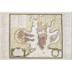
Plan general de la Ville capitale de Malta..
Attractive large scale plan of Valetta on Malta. With numbered key to the principal places of interest.The print has unfortunately some reinforcements of missing parts, c...
Date: Paris 1757
Selling price: ????
Please login to see price!
Sold
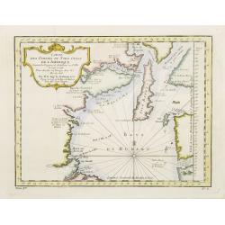
Carte Des Parties Du Nord-Ouest De L'Amerique Suivant les Voyages de Middleton et d Ellis..
Very nicely engraved chart that covers most of Hudson's Bay. Locates Fort Prince of Wales and Fort York, the Ottawa Islands (here the Bakers Dozen), the track of Henry El...
Date: Paris 1757
Selling price: ????
Please login to see price!
Sold
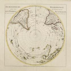
SOUTHERN HEMISPHERE.
Large map of the southern hemisphere, with the south pole in the center, showing also the southern parts of America, Africa, Asia and Australia. Originally designed and e...
Date: Amsterdam, 1757
Selling price: ????
Please login to see price!
Sold
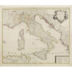
l''Italie.
Large map of Italy, Sicily, Sardinia, Corsica, part of the Balkan, France and northern Africa. Dressee sur les observations de Mrs de l'Academie royale etc. Originally de...
Date: Amsterdam, 1757
Selling price: ????
Please login to see price!
Sold in 2008
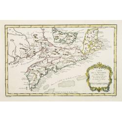
Carte de l' Accadie et Pais Voisins..
First state of this nice map with a decorative rococo-style cartouche. It shows in good detail Prince Edward Island, here called Isle Saint Jean, and covers all of Nova S...
Date: Paris 1757
Selling price: ????
Please login to see price!
Sold
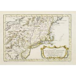
Carte de la Nouvelle Angleterre, Nouvelle Yorck et Pensilvanie..
Lovely map of the northeast, fully engraved with mountains. The colonies are shown confined east of the Appalachian Mountains, with the "Nations Iroquoises" wes...
Date: Paris 1757
Selling price: ????
Please login to see price!
Sold
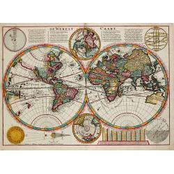
De Werelt Caart.
Dutch so-called ' Staten' bibles, published between 1637 and c. 1760, contained 5 maps: The World, ' Paradise', The Perigrinations, The Promised Land Canaan, The Travels ...
Date: Amsterdam, S. Luchtmans, 1757
Selling price: ????
Please login to see price!
Sold in 2008
D' Reyse des Apostels Pauli na Roomen.
Dutch so-called 'Staten' bibles, published between 1637 and c. 1760, contained 5 maps: The World, 'Paradise', The Perigrinations, The Promised Land Canaan, The Travels of...
Date: Amsterdam / Leiden, R. & J. Wetstein / W. Smith / S. Luchtmans, 1757
Selling price: ????
Please login to see price!
Sold
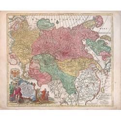
Spatiosissimum Imperium Russiae Magnae juxta recentissimas Observationes Mappa Geographica . . .
Decorative map of Russia, from Livonia to Kamchatka, China, Tibet, and part of Japan Filled with place names, a nomadic tent encampments in Mongolia.Kamchatka in a curi...
Date: Augsburg, 1757
Selling price: ????
Please login to see price!
Sold in 2013
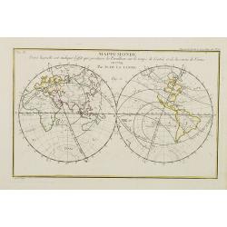
Mappemonde dans laquelle est indiqu\'e l\'effet que produira la parallaxe sur le temps de l\'entr\'ee et de la sortie de Venus en 1769 / par M. de la Lande.
Double hemispherical world map showing the transit of Venus in front of the Sun in 1769. In upper right margin: Mem. de l\'Ac. R. des Sc 1757, Page 250 Pl. 15. In upper l...
Date: Paris, 1757
Selling price: ????
Please login to see price!
Sold in 2008

Allgemeine Historie der Reisen zu Wasser und zu Lande: oder Sammlung aller Reisebeschreibungen, welche bis itzo in verschiedenen Sprachen von allen Volkernherausgegeben worden. . .
Collection of travel exploration of South and North America. With 19 copperengravings (10 folded maps). The maps of N. Bellin showing: (1) South-American continent, (2) G...
Date: Leipzig, 1757
Selling price: ????
Please login to see price!
Sold in 2009
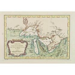
Carte Des Lacs Du Canada Pour sevir a l'Histoire Generale des Voyages.
Showing the all the Great Lakes in the traditional Bellin configuration. Jacques Nicolas Bellin (1703-1772) was one of the most important and proficient French cartograph...
Date: Paris, 1757
Selling price: ????
Please login to see price!
Sold in 2011
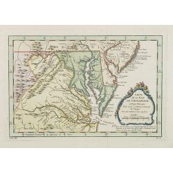
Carte de la Baye de Chesapeack et Pays Voisins. . .
Very attractive map showing both Chesapeake and Delaware Bays and the coast of New Jersey, Maryland and Virginia down to Cape Charles and Cape Henry. Including Philadelph...
Date: Paris, 1757
Selling price: ????
Please login to see price!
Sold
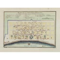
Plan de la Nouvelle Orleans. . .
An important transitional and very detailed early map of New Orleans, copied after the original manuscript town-plan of the city drafted by Le Blond de la Tour in 1722. I...
Date: Paris, 1757
Selling price: ????
Please login to see price!
Sold in 2009
Carte topographique de l'isle Minorque dediée et presentée au roy par le chevalier de Beaurain. . . et communiquée au public par les Heritiers de Homan en l'an 1757.
A rare map depicting the island of Minorca. The upper left is decorated with a stunning title cartouche.The German text on the left side contains a lengthy description of...
Date: Nuremberg, 1757
Selling price: ????
Please login to see price!
Sold in 2010