Browse Listings
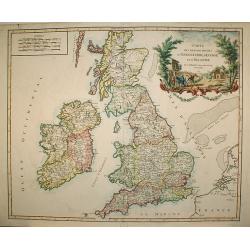
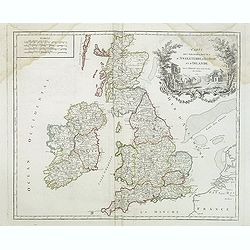
Carte des grandes routes d'Angleterre, d'Ecosse.. Irlande.
Decorative map of British Isles with Rococo title cartouche. Engraved by Delahaye.
Date: Paris, 1757
Selling price: ????
Please login to see price!
Sold in 2009
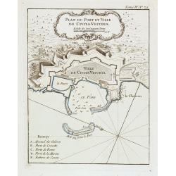
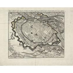
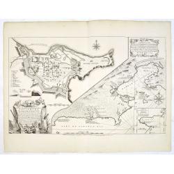
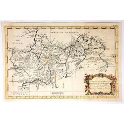
Plan du Port et Ville de Civita-Vecchia.
A military chart of Civita-Vecchia's fortifications and fort in the province of Rome. With a key : A-E.Jacques Nicolas Bellin (1703-1772) was one of the most important an...
Date: Paris, 1757
Selling price: ????
Please login to see price!
Sold in 2020
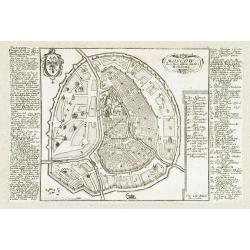
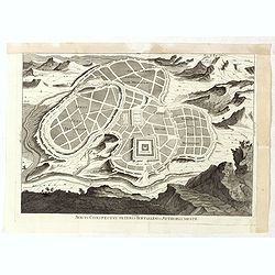
Moscow.
Very rare bird's-eye plan of Moscow. To the sides a historical description and a numbered key.George Christophe Kilian (1709-1780) active as engraver of Augsburg publishe...
Date: Augsburg 1757
Selling price: ????
Please login to see price!
Sold in 2009
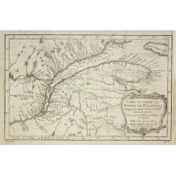
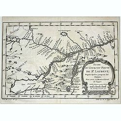
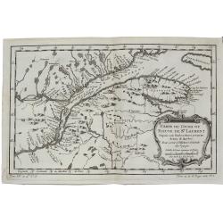
Carte du Cours du Fleuve de St.Laurent ? Quebec.
A folding map of Prevost's 'Hist. des Voyages', depicting the course of the St. Lawrence river from Quebec to the Atlantic.Jacques Nicolas Bellin (1703-1772) was one of t...
Date: Paris, 1757
Selling price: ????
Please login to see price!
Sold in 2009
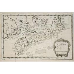
Carte de l' Accadie et Pais Voisins . . .
A nice folding map with a decorative rococo-style cartouche. It shows in good detail Prince Edward Island, here called Isle Saint-Jean, and covers all of Nova Scotia incl...
Date: Paris, 1757
Selling price: ????
Please login to see price!
Sold in 2011
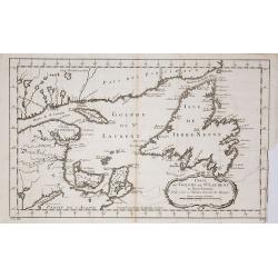
Carte du Golphe de St.Laurent et Pays Voisins ?
Accurate map depicting the gulf of St. Lawrence and the surrounding area, included the isle of Newfoundland.Jacques Nicolaas Bellin (1703-1772) was one of the most import...
Date: Paris, 1757
Selling price: ????
Please login to see price!
Sold in 2009
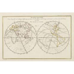
Mappemonde dans laquelle est indique l'effet que produira la parallaxe sur le temps de l'entr'ee et de la sortie de Venus en 1769 / par M. de la Lande.
Double hemispherical world map showing the transit of Venus in front of the Sun in 1769. In upper right margin: Mem. de l'Ac. R. des Sc 1757, Page 250 Pl. 15. In upper le...
Date: Paris, 1757
Selling price: ????
Please login to see price!
Sold in 2009
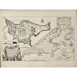
A Plan of the City, and Fortifications, of Louisburg, from a Survey made by Richard Gridley / A Plan of the City and Harbour of Louisburg
Important and very rare map describing the first siege of Louisbourg in 1745The copper engraved map published by Thomas Jefferys in 1757 showing the Siege of Louisbourg, ...
Date: London, 1757
Selling price: ????
Please login to see price!
Sold in 2011
Plan de Breslau et du Siége de S.M. le R. de Pr. depuis le commencem. iusqu'au 18. de decemb. 1757. jour de la capitul
A rare plan of Breslau (today Wroclaw) during the siege 1757. It shows the day of the capitulation 18. December 1757. Engraved by J.C. Back. With a key below the title.
Date: 1757
Selling price: ????
Please login to see price!
Sold in 2011
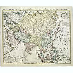
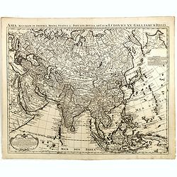
Carte d'Asie. . .
This is an updated re-issue of de L'Isle's map of 1723. An inset shows the northeastern tip of the continent which has been altered significantly from the earlier version...
Date: Amsterdam, 1757
Selling price: ????
Please login to see price!
Sold in 2011

Les Indes Orientales, ou sount distingues les Empires et Royaumes..
Interesting regional map extending from India, the Ganges and the Maldives Islands to Hai-nan, Cochin china, Malacca and Sumatra. Includes islands, towns, mountains, rive...
Date: Paris, 1757
Selling price: ????
Please login to see price!
Sold in 2011
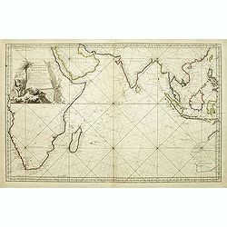
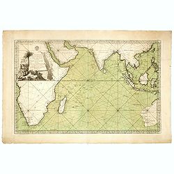
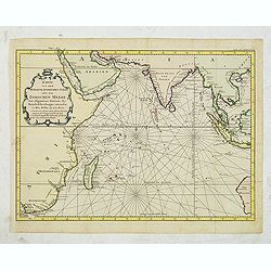
Carte Réduite de l'Océan Oriental ou Mer des Indes.
A of the Indian Ocean, with its islands and adjacent coasts in detail. The chart stretches from the Congo coast, around Africa, Arabia, India and South East Asia, includ...
Date: Paris, 1757
Selling price: ????
Please login to see price!
Sold in 2011
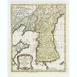
Carte de la province de Quan-tong, ou Lyau-tong et du Royaume de Kau-li. . .
Map of Korea. The map is of interest for the use of East Sea, the sea between Korea and Japan, here called "Mer de Corée.Decorative title cartouche in lower left co...
Date: Paris, 1757
Selling price: ????
Please login to see price!
Sold in 2013
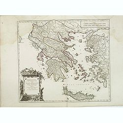
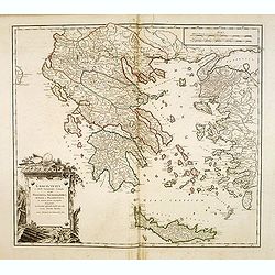
Graecia Vetus ex schardis Sansonianis desumpta. . .
Decorative map of ancient Greece and neighboring Islands in the Ionian and Aegean Seas, with a large decorative cartouche. Also shows a fair amount of Turkish Asia, along...
Date: Paris, 1757
Selling price: ????
Please login to see price!
Sold in 2012
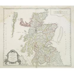
Le Royaume d'Ecosse.
Detailed map of Scotland, from and early edition of DeVaugondy's Atlas Universel. Includes towns, mountains, rivers, lakes and a host of other details. Decorative Cartouc...
Date: Paris, 1757
Selling price: ????
Please login to see price!
Sold in 2013
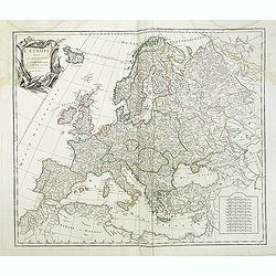
L'Europe divisée en ses principaux Etats,. . .
Detailled map of Europe from his "Atlas Universel".Gilles Robert de Vaugondy (1688–1766), also known as Le Sieur or Monsieur Robert, and his son, Didier Rober...
Date: Paris, ca.1757
Selling price: ????
Please login to see price!
Sold in 2011
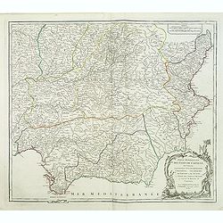
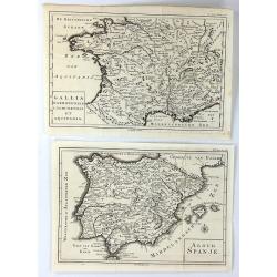
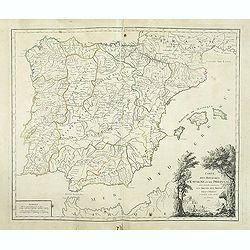
Partie Meridionale des Etats de Castille où se trouvent l'Andalousie et le Roy.me de Grenade.
Decorative and highly detailed map of Southwestern Spain and including a decorative cartouche from his "Atlas Universel".Gilles Robert de Vaugondy (1688–1766)...
Date: Paris, 1757
Selling price: ????
Please login to see price!
Sold in 2011
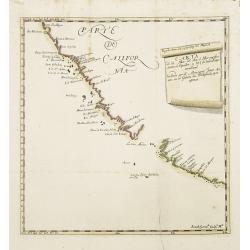
Carta de la Mar del Sur, ò Mar pacifico, entre el Equador, y 39½ de latitud Septentrional hallada por el Almirante Jorge Anson en el Galion de Philipinas, que apresò.
Scarce map of the west coast of America, covering part of Mexico and California, copied from Anson's chart of 1748. Reaches as far north as Punta de los Reyes and Los Far...
Date: Madrid, 1757
Selling price: ????
Please login to see price!
Sold in 2013
A Plan of the City, and Fortifications, of Louisburg, from a Survey made by Richard Gridley / A Plan of the City and Harbour of Louisburg.
Important and very rare map describing the first siege of Louisbourg in 1745 - Very rare first state of the Gridley/Jefferys plan of the 1745 Siege of Louisbourg.Large Fr...
Date: London, Thomas Jefferys, 20 April 1757
Selling price: ????
Please login to see price!
Sold in 2013
Graecia Vetus ex schardis Sansonianis desumpta. . .
Decorative map of ancient Greece and neighboring Islands in the Ionian and Aegean Seas, with a large decorative cartouche. Also shows a fair amount of Turkish Asia, along...
Date: Paris, 1757
Selling price: ????
Please login to see price!
Sold in 2012
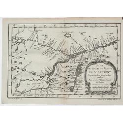
Suite du Cours du Fleuve de St.Laurent depuis Quebec jusqu' au Lac Ontario.
A map of Prevost's 'Hist. des Voyages', depicting the course of the St. Lawrence river from lake Ontario to Quebec.Jacques Nicolaas Bellin (1703-1772) was one of the most...
Date: Paris, 1757
Selling price: ????
Please login to see price!
Sold in 2013
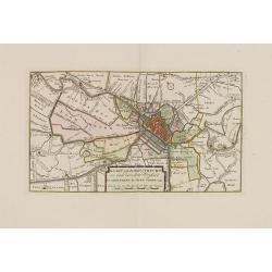
Kaart van de Stad Utrecht..
Detailed map of the town of Utrecht. Including several town along the river Vecht: Maarsen, Zuylen, Amelisweert, etc.Isaac Tirion was born in Utrecht ca. 1705. He came to...
Date: Amsterdam, 1757
Selling price: ????
Please login to see price!
Sold in 2013
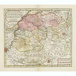
Nieuwe en naukeurige kaart van de drie landen van Overmaaze Valkenburg, Daalhem en s'Hertogenrade.
Detailed map of southern part of Limburg, including and east of Maastricht.Isaac Tirion was born in Utrecht ca. 1705. He came to Amsterdam ca. 1725. Tirion published a nu...
Date: Amsterdam, 1757
Selling price: ????
Please login to see price!
Sold in 2013
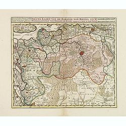
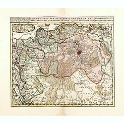
Nieuwe kaart van de Baronie van Breda. . .
Detailed map of western part of Brabant.
Date: Amsterdam, 1757
Selling price: ????
Please login to see price!
Sold in 2013
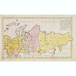
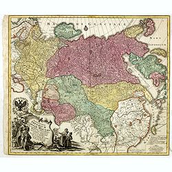
Russiae Imperium.
Scarce map of greater Russia, extending from Livonia in the west to Kamchatka. To the south it runs from Georgia (not shown as part of Russia) across the Caspian and Uzbe...
Date: Augsburg, 1757
Selling price: ????
Please login to see price!
Sold in 2013
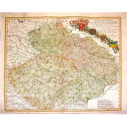
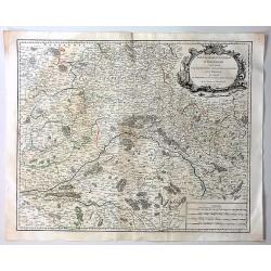
Carte Generale du Royaume de Boheme du Duche de Silesie et des Marquisats de Moravie et de Lusace. . .
Lovely copper engraved map shows Bohemia, Lustia & Silesia with high detail of cities, towns, rivers, lakes, mountains & forests. Features beautiful, ribboned, he...
Date: Nuremberg, 1757
Selling price: ????
Please login to see price!
Sold in 2013
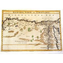
Egipten, Libie en Cirenaika.
Unusual map of Egypt & Libya. (Cirenaika historically was a region in Libya)
Date: Utrecht, 1757
Selling price: ????
Please login to see price!
Sold in 2015
Theatrum belli Russorum Victoriis illustratum sive Nova et accurata Turcicarum et Tartaricum. . .
Uncommon and decorative map of Ukraine, showing the theatre of the Russo-Turkish War in the Ukraine in 1735-1739. The map gives detailed information of the fortifications...
Date: Nuremberg, ca. 1757
Selling price: ????
Please login to see price!
Sold in 2013
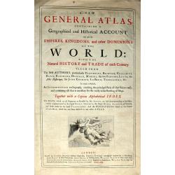
(Title plate from the rare Atlas ‘A New General Atlas Containing a Geographical and Historical Account of all the Empires, Kingdoms and other Dominions of the World: by John Senex. M.DCC.XXI.)
The Title plate from the rare Atlas ‘A New General Atlas Containing a Geographical and Historical Account of all the Empires, Kingdoms and other Dominions of the World:...
Date: London, 1757
Selling price: ????
Please login to see price!
Sold in 2016
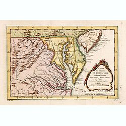
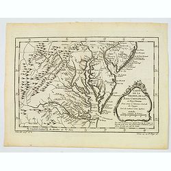
Carte de la Baye de Chesapeack et Pays Voisins. . .
Very attractive map showing both Chesapeake and Delaware Bays and the coast of New Jersey, Maryland and Virginia down to Cape Charles and Cape Henry. Including Philadelph...
Date: Paris, 1757
Selling price: ????
Please login to see price!
Sold in 2018
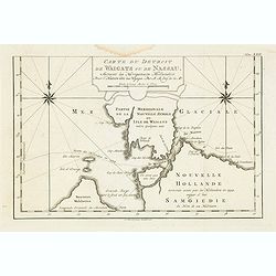
Carte Du Detroit de Waeigats ou De Nassau...
Detailed regional map of the Strait of Waeigats in the Arctic Sea. Includes a decorative title cartouche. One of the maps produced by Nichlas Bellin for Prevost d'Exiles ...
Date: Paris, 1757
Selling price: ????
Please login to see price!
Sold in 2020
Nieuwe kaart van de Baronie van Breda en 't Markgraafschap van Bergen op Zoom. . .
Detailed map of western part of Brabant, centered on Breda.Isaac Tirion was born in Utrecht ca. 1705. He came to Amsterdam ca. 1725. Tirion published a number of importan...
Date: Amsterdam, 1757
Selling price: ????
Please login to see price!
Sold in 2016
Carte d\'Asie. . .
This is an updated re-issue of de L'Isle's map of 1723. An inset shows the northeastern tip of the continent which has been altered significantly from the earlier version...
Date: Amsterdam, 1757
Selling price: ????
Please login to see price!
Sold in 2014
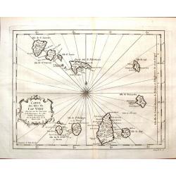
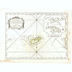
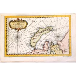
Carte des Isles du Cap Verd.
Featuring the Portugese Cape Verde Islands that are about 500 miles off the most western part of Africa in the Atlantic Ocean. Included are the islands of Bonavista, Sal,...
Date: Paris, 1757
Selling price: ????
Please login to see price!
Sold in 2016
Spatiosissimum Imperium Russiae Magnae juxta recentissimas Observationes Mappa Geographica . . .
Decorative map of greater Russia, extending from Livonia in the west to Kamchatka, China, Tibet, Taiwan, Korea and part of Japan in the east. To the south it runs from Ge...
Date: Augsburg, 1757
Selling price: ????
Please login to see price!
Sold in 2014
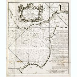
Carte géométrique de l'Entrée de la Rivière de Loire Représentée de Basse Mer dans les grandes Marées des Nouvelles et Pleines Lunes
Right hand part of a two sheet chart of the exit of the River Loire, prepared and published by Nicolas Magin (1663-1742). Engraved by Dheulland.
Date: Paris, 1757
Selling price: ????
Please login to see price!
Sold in 2015
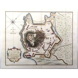
La ville de Cayenne de Stad Cayenne.
A fine city plan of the town of Cayenne in French Guyana in South America by J.N. Bellin, and engraved by J. Van Der Schley in 1757. From "Histoire Generale des Voya...
Date: Paris, 1757
Selling price: ????
Please login to see price!
Sold in 2016
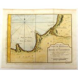
Carte de la Rade de Benguella et Riviere de Cantonbelle.
Detailed map of the region of West Africa between Angola and Catumbela. Fort Kabuto is pointed out as probably being founded by the English.
Date: Paris, 1757
Selling price: ????
Please login to see price!
Sold in 2016
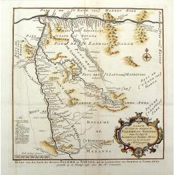
Carte du Cours des Rivieres de Falemeet Sanaga Dans les Pays de Bamucet Tamba Awra.
Interesting original map of western Mali with the Senegal and Niger Rivers showing the important Bambuk region. This is the area that has Cameroon gold mining. Engraved b...
Date: Paris, 1757
Selling price: ????
Please login to see price!
Sold in 2018
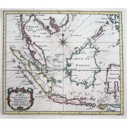
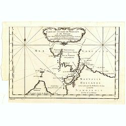
Carte Des Isles De Java, Sumatra, Borneo &c Les Detroits de la Sonde Malaca et Banca Golphe De Siam...
Detailed map of Southeast Asia, with the Gulf of Siam, Cambodia, Brunei, Mindoro in the Philippines, Lombok, Bali, Java and Sumatra, Borneo and the Malay Peninsula.A deco...
Date: Paris, 1757
Selling price: ????
Please login to see price!
Sold in 2016
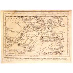
Kaart van Klyn-Bukharia, en de Nabuurige Landen.
Interesting map of Klyn-Bukharia and Nabuurige Countries, which includes Central Asia and the current countries of Kazakstan, Turkmenistan, Uzbekistan, Tajikistan, and Ky...
Date: The Hague, 1757
Selling price: ????
Please login to see price!
Sold in 2017
Carte des grandes routes d'Angleterre, d'Ecosse et d'Irlande.
Decorative map of British Isles with Rococo title cartouche. Engraved map by Delahaye. Relief shown pictorially.
Date: Paris, 1757
Selling price: ????
Please login to see price!
Sold in 2015
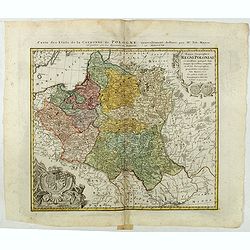
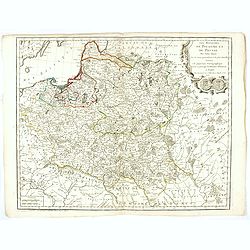
Mappa Geographica Regni Poloniae ex novissimis quotquot sunt mappis specialibus composita et al L.L. Stereographicae projectionis revocata a Tob. Mayero. . . .
Decorative map of Poland after Tobias Mayer who was based on Barnikel's map of Curland (1747) and Jan Nieprzecki's map of Lithuania (1749).Poland extends from Glogau and ...
Date: Nuremberg, 1757
Selling price: ????
Please login to see price!
Sold in 2020
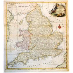
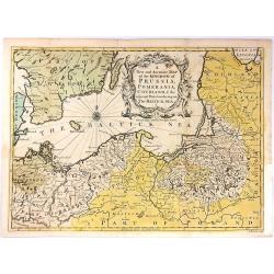
A New and Accurate Map of that District of Great Britain called England & Wales.
A very detailed map of Great Britain by Thomas Kitchin, from Walpoole's New & Complete British Traveller, published in 1784.Thomas Kitchin was among the most producti...
Date: London, 1757
Selling price: ????
Please login to see price!
Sold in 2015
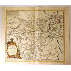
Evache de Paderborn.
Fine large map of the Archdiocese of Paderborn. It is an Archdiocese of the Latin Rite of the Roman Catholic Church in Germany. It was a diocese from its foundation in 79...
Date: Paris, 1757
Selling price: ????
Please login to see price!
Sold in 2020
Carte reduite de l'isle d'Aurigni et des isles et roches voisines dressée au Depost des Cartes et Plans . . .
Sea of Guernsey.Relief shown by hachures. Depths shown by soundings. It shows soundings, anchorage's, channels, shoals, navigational sightings.
Date: Paris, 1757
Selling price: ????
Please login to see price!
Sold in 2015
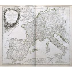
Carte de l'Empire d'Allemagne ou sont marquees exactement les routes des postes.
A stunning, scarce 1757 map of the German Empire by Robert de Vaugondy. It covers from Dunkirk in the east of France to Elblag in Poland, and south as far as the Gulf of ...
Date: Paris, 1757
Selling price: ????
Please login to see price!
Sold in 2019
A New and Accurate Map of the Kingdom of Prussia,...
A pleasing and a detailed map of the Kingdom of Prussia
Date: London, 1757
Selling price: ????
Please login to see price!
Sold in 2016
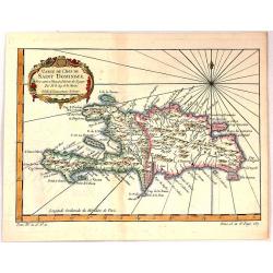
Carte de L'Isle de Saint Dominique.
A fine map of the island of Saint Dominique or Santo Domingo or Hispaniola, divided by the countries of Haiti and Dominican Republic. From the atlas “Histoire Generale ...
Date: Paris, 1757
Selling price: ????
Please login to see price!
Sold in 2018
(2 Maps) Aloud Spanje & Gallia Narbonensis Lugdunensis et Aquitania
Two unusual maps of Ancient Europe by H. Besseling in Utrecht ca. 1757. One is of Ancient Spain (Aloud Spanje), and the other is of Ancient France, (Gallia Narbonensis et...
Date: Utrecht, 1757
Selling price: ????
Please login to see price!
Sold in 2018
Jacques Nicolas Bellin: Carte Reduite De L'Ocean Oriental ou Mer Des Indes Seconde Edition Pour Servir aux Vaisseau du Roy . . . Par order de M. De. Machault . . . MDCC LVII
This map is a second state of Bellin's map of the Indian Ocean and is significantly revised from the first edition of 1740. Significant revisions are shown in Australia a...
Date: Paris, 1757
Selling price: ????
Please login to see price!
Sold in 2018
Imperium Caroli Magni Occidentis Imperatoris...
An attractive and detailed map of Charlemagne's empire, from England to the Mediterranean Sea. Includes the Low Countries, Germany, France, Spain, Switzerland, Austria, I...
Date: Paris, 1757
Selling price: ????
Please login to see price!
Sold in 2016
Les Royaumes De Pologne Et De Prusse Par Tobias Mayer . . . Chez Daumont . . . 1757
Rare map of Poland, Prussia, Russia and surrounding regions, based upon the map of Tobias Mayer.Published by Jean-Francois Daumont, who was active in Paris between approx...
Date: Paris, 1757
Selling price: ????
Please login to see price!
Sold
Eine Karte Von Dem Orenburger.
Fine detailed engraved map of the Orenburg region of Russia. It has a lovely Baroque cartouche. It was by Jonas Hanway in 1754.Orenburg is the administrative center of Or...
Date: Frankfurt, 1757
Selling price: ????
Please login to see price!
Sold in 2019
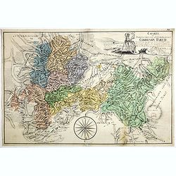
Gouvernement General D'Orleanois.
A beautiful 1753 de Vaugondy map of the Orleans Region in Central France. It covers from Corbeil-Essonnes south to Vatan in the north and from Tours east as far as Sens a...
Date: Paris, 1757
Selling price: ????
Please login to see price!
Sold in 2019
Charte Braunscheweigisch Luneburgischen Communion Hartze . . .
Manuscript drawn by L.F. Knorre in 1757 after information provided by J.H. Eggers. Showing part of the Duchy of Brunswick-Luneburg in what is now northern Germany.The map...
Date: Germany, 1757
Selling price: ????
Please login to see price!
Sold
Plan de la ville de Berlin capitale de l'Électorat de Brandebourg et la résidence ordinaire du roi de Prusse. Berlin et Amsterdam, Sr. Neaulm, 1757.
Superb and very rare planof Berlin, reduced after a 4 sheet plan made under the direction of the Count of Schmettau. The map was co-published in Amsterdam and Berlin by J...
Date: Berlin, Amsterdam, 1757
Selling price: ????
Please login to see price!
Sold in 2017
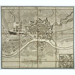
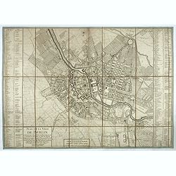
Plan de Cassel vérifié par Léopold capitaine ingénieur.
Beautiful town-plan of Kassel in Bavaria, reviewed by the captain engineer Johann Christian Leopold.Below right, an inset map of Kassel and its surroundings. The north is...
Date: Paris, 1757
Selling price: ????
Please login to see price!
Sold in 2017
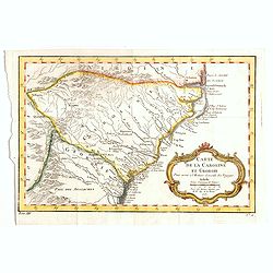
Carte de la Caroline et Georgie..
Common map depicting the eastern coast of the United States from Savannah to Edenton as well as the inland corresponding to today Carolinas. Includes part of Georgia.Jacq...
Date: Paris, 1757
Selling price: ????
Please login to see price!
Sold in 2017
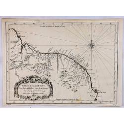
Carte de la Guyane.
A map of the Guyanas - present day Guyana, Suriname and French Guiana, including Paramaribo and Cayenne. The map features a decorative rococo style title cartouche. By Be...
Date: Paris, 1757
Selling price: ????
Please login to see price!
Sold in 2018
![[detail from] Nova illustrissimi principatus Pomeraniae descrptio.. .](/uploads/cache/41152-250x250.jpg)
[detail from] Nova illustrissimi principatus Pomeraniae descrptio.. .
"only a small number of copies were printed and so this edition is a very rare object today" (Scharfe).
Date: Amsterdam, 1618-1757
Selling price: ????
Please login to see price!
Sold in 2018
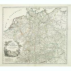
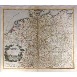
Carte de l'empire d'Allemagne. . .
Detailed map of Germany from his "Atlas Universel".Gilles Robert de Vaugondy (1688–1766), also known as Le Sieur or Monsieur Robert, and his son, Didier Rober...
Date: Paris, 1757
Selling price: ????
Please login to see price!
Sold
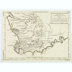
Le Pays des Hottentots aux environs du Cap de Bonne Espérance. . .
A good, competent, engraved map of Cape of Good Hope. The geographical features are typical, with somewhat exaggerated bays, inlets and prominent mountain ranges.The west...
Date: Paris, 1757
Selling price: ????
Please login to see price!
Sold in 2020
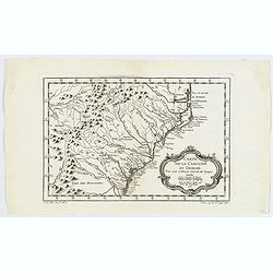
Carte de la Caroline et Georgie.
A pleasant map depicting the eastern coast of the United States from Savannah (GA) to Edenton (NC) as well as the inland corresponding to today Carolinas. Includes part o...
Date: Paris, 1757
Selling price: ????
Please login to see price!
Sold in 2019
Novus conspectus veteris Ierusalem ex autoris mentes.
Copper engraving with bird’s eye view of ancient Jerusalem. Royal palace, gardens and Solomon’s grave are well-highlighted. Verso is blank.
Date: Amsterdam, 1757
Selling price: ????
Please login to see price!
Sold in 2019
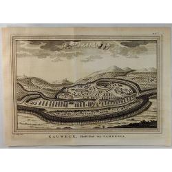
Eauweck Capitale de Camboye.
A highly detailed 1757 Bellin copper engraved panoramic view of the city of Lawec, Cambodia situated halfway along the Mekong River on the way to Phnom Penh. A new Lawec ...
Date: Paris, 1757
Selling price: ????
Please login to see price!
Sold in 2019
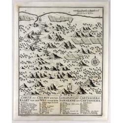
Carte du Chemin Entre Samarang et Cartasoera.
A highly detailed 1757 Bellin map depicting the Road between Semarang and Kartasuro in Java, Indonesia. Semarang is the capital and largest city of Central Java province ...
Date: Paris, 1757
Selling price: ????
Please login to see price!
Sold in 2019
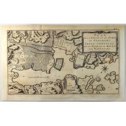
Plan de la Ville et du Port de Nangasaki.
A fine copper engraved map featuring a 'birds-eye' view of Nagasaki, Japan. The map is oriented to the southwest with a bold compass rose. The map locates the principal p...
Date: Paris, 1757
Selling price: ????
Please login to see price!
Sold in 2019
Carte de la Virginie, de la Baye Chesapeack, et Pays Voisins.
An attractive and detailed map of the Chesapeake, Virginia, Maryland, Delaware, just before the settlement between Penn and Lord Baltimore, with Delaware properly shown a...
Date: Paris, 1757
Selling price: ????
Please login to see price!
Sold in 2019
![[detail from] Nova illustrissimi principatus Pomeraniae descrptio.. .](/uploads/cache/43600-250x250.jpg)
[detail from] Nova illustrissimi principatus Pomeraniae descrptio.. .
One sheet from THE MOST IMPORTANT EARLY MAP OF POMERANIA, the region on the south coast of the Baltic shared between Germany and Poland, from the Recknitz River near Stra...
Date: Amsterdam, 1618-1757
Selling price: ????
Please login to see price!
Sold in 2019
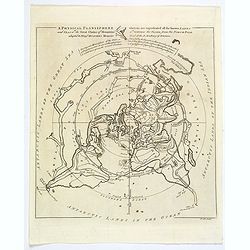
A Physical Planisphere wherein are represented all the known Lands and Seas in the Great Chains of Mountains. . .
This is the elegant 1757 Philippe Buache map of the world represented on an unusual polar projection rendered from the North Pole. The map covers from the North Pole Arct...
Date: London, 1757
Selling price: ????
Please login to see price!
Sold in 2019
Carte des Royaumes d'Espagne et de Portugal.
Detailed map of Spain, Portugal and Baleares islands. Showing also southwestern part of France and north Africa from his "Atlas Universel".Gilles Robert de Vaug...
Date: Paris, 1757
Selling price: ????
Please login to see price!
Sold in 2019
Carte du Cours du Fleuve de St. Laurent Depuis son Embouchure Jusqu'au Dessus de Quebec.
A detailed regional map of Canada, extending from Anticosti Island to just west of Quebec, centred on the St. Laurence River. From Abbe Prevost's "Histoire Generale...
Date: Paris, 1757
Selling price: ????
Please login to see price!
Sold in 2021
Suite du Cours du Fleuve de St. Laurent Depuis Quebec Jusqu'a au Lac Ontario.
A detailed map of the region between Lake Ontario and the St. Lawrence River to Quebec. The map extends to Lake Champlain and Lake George, as well as Lake Nepissing with...
Date: Paris, 1757
Selling price: ????
Please login to see price!
Sold in 2019
Karte von dem Morgenlaendischen Ocean oder dem Indischen Meere. Zur allgemeinen Historie der Reisebeschreibungen entworfen. . . .
Copper engraving, decorative handcolored in wash and outline. A fine and detailed larger map of the Indian Ocean from Africa towards Southeast Asia and New Holland (Austr...
Date: Leipzig, Merkur, 1758
Selling price: ????
Please login to see price!
Sold in 2013
Partie de la Mer Glaciale Contenant La Nouvelle Zemble.
Detailed copper engraved map of Russia's Nova Zembla and a portion of the Northwest Passage. Produced by Bellin for "L'Histoire Generale des Voyages". Large bal...
Date: Paris, 1758
Selling price: ????
Please login to see price!
Sold in 2015
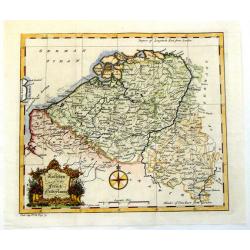
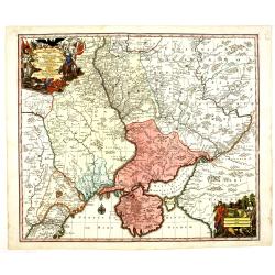
Austrian and French Netherlands.
Interesting copper engraved map featuring the Flanders and Brabant regions bordered by Luxemburg and Artois. Featuring a decorative Rococo title cartouche and a prominent...
Date: London, 1758
Selling price: ????
Please login to see price!
Sold in 2013
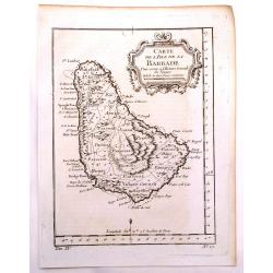
Carte de L'isle de la Barbade.
One of the finest early maps or charts of Barbados. The island is divided into parishes and details cities & towns, mountains, forests, anchorages, shoals, rocks, etc...
Date: Paris, 1758
Selling price: ????
Please login to see price!
Sold in 2017
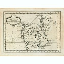
Carte Du Spits-Berg Suivant les Hollandois . . . 1758
A decorative map of Spitsbergen (Svalbard) with the adjacent islands of Franz Josef Land and Jan Mayan. The geographical features are typical with somewhat exaggerated ba...
Date: Paris, 1758
Selling price: ????
Please login to see price!
Sold in 2021
Carte du Detroit de Waigats ou de Nassau.
Showing the Dutch voyage of 1594 which proved Nova Zemlya was an island separated from the continent by the "le Waigats Detroit". Several sounding shown and one...
Date: Paris, 1758
Selling price: ????
Please login to see price!
Sold in 2020