Browse Listings
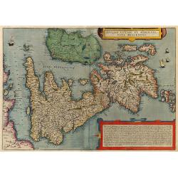
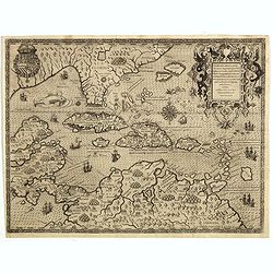
Angliae, Scotiae et Hibernie Nova Descriptio.
Rare map of the British Isles in original color from De Jode's Speculum orbis terrae. Oriented with West at the top. The map was based on Mercator's wall map from 1554. G...
Date: Antwerp, 1593
Selling price: ????
Please login to see price!
Sold in 2009
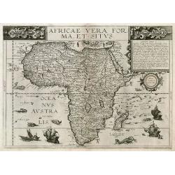
Africa Vera Forma, et Situs.
This rare map is an interesting amalgamation of cartographical sources. Cornelis prepared this map for the second edition of the Speculum after his father's death in 1591...
Date: Antwerp, 1593
Selling price: ????
Please login to see price!
Sold in 2009
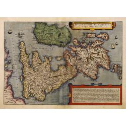
Angliae, Scotiae et Hibernie Nova Descriptio.
Rare map of the British Isles in original color from De Jode's Speculum orbis terrae. Oriented with West at the top. The map was based on Mercator's wall map from 1554. G...
Date: Antwerp, 1593
Selling price: ????
Please login to see price!
Sold in 2010
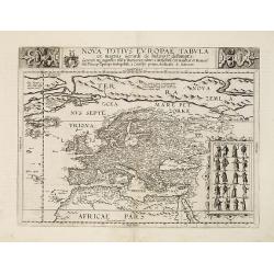
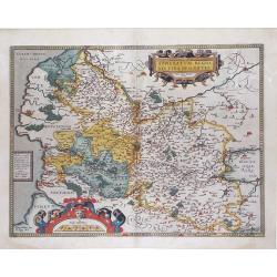
Nova totius Europae tabula.
Very rare map of the continent of Europe, with in top a dedication to Theodor Echter von Mespelbrunn. With an oversized Nova Zemla, including the fictions islands of the ...
Date: Antwerp, 1593
Selling price: ????
Please login to see price!
Sold in 2011
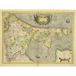
Hollandt comitatus Utrecht episcop.
The rare first edition, with a large marshland in the Zuiderzee filled with ducks.The country of Holland, i.e.: present Noord- and Zuid-holland, plus Utrecht. Oriented we...
Date: Duisburg, 1593
Selling price: ????
Please login to see price!
Sold in 2011
ARTOIS Atrebatum regionis vera descriptio.
De Jode's superb map of Artesia/Flanders. Includes the cities of Calais, Lille, Lens, Arras, Douai, Boulogne-sur-mer,... The map is based on the manuscript map Jacques Su...
Date: Antwerp, 1593
Selling price: ????
Please login to see price!
Sold in 2011
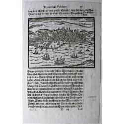
Lissabon.
Rare, small view of Lisbon, from the 'Theatrum Urbium' by Abraham Saur, first published in 1581.
Date: Frankfurt, 1593
Selling price: ????
Please login to see price!
Sold in 2020
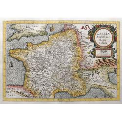
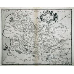
Galliae Amplissimi Regni tabula.
Very rare map which was only published once in the 1593 edition of the Speculum orbis terrae. A highly decorative and beautifully engraved map. Centered on France, also ...
Date: Antwerp, 1593
Selling price: ????
Please login to see price!
Sold in 2021
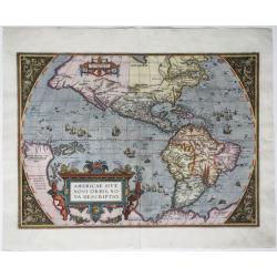
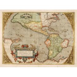
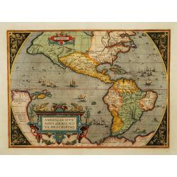
Americae sive Novi Orbis, Nova Descriptio.
An engraved map of the Americas, image 357 x 493 mm (452 x 550 mm sheet). Elaborate baroque title cartouche, may ships and sea-monster, Italian text on verso. One of the ...
Date: Antwerp, 1593
Selling price: ????
Please login to see price!
Sold in 2020
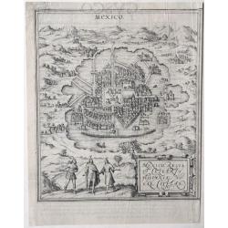
Mexico, Regia & Celebris Hispania Novae Civitas.
An old map with a bird's-eye view of Mexico City situated, as it was, in the middle of a lake, by Georg Braun and Frans Hogenberg, from the: 'Civitates Orbis Terrarum', K...
Date: Cologne, 1572-1593
Selling price: ????
Please login to see price!
Sold in 2020
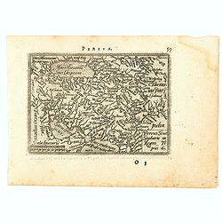
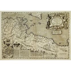
Percici sive Sophorum Regni Tipus.
A nice detailed miniature map of Persia from one of only two Italian editions of Philippe Galle's pocket atlas, the 'Epitome', a reduced version of the Ortelius 'Theatrum...
Date: Antwerp, 1593
Selling price: ????
Please login to see price!
Sold in 2020
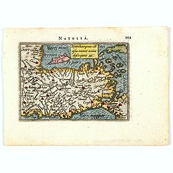
Natoliae quae oli asia minor nova descriptio.
A nice detailed miniature map of Natolia (Turkey in Asia) from one of only two Italian editions of Philippe Galle's pocket atlas, the 'Epitome', a reduced version of the ...
Date: Antwerp, 1593
Selling price: ????
Please login to see price!
Sold in 2021
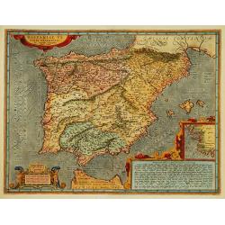
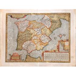
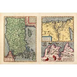
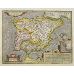
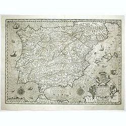
![[Spain and Portugal]](/uploads/cache/47718-250x250.jpg)
[Spain and Portugal]
A rare map of Spain and Portugal engraved by Jan and Lucas van Deutecom and published by Gerard de Jode, Antwerp 1593. Latin text on verso.The map appeared in the second ...
Date: Antwerp, 1593
Selling price: ????
Please login to see price!
Sold in 2025
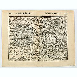
America.
A nice late 16th century, finely engraved map of America, published in Bologna in 1594 by Giuseppi Rossaccio. The map is interesting for the fact of its number of curious...
Date: Bologna, ca. 1594
Selling price: ????
Please login to see price!
Sold in 2020
![[Departure from Lisbon for Brazil, the East Indies and America]](/uploads/cache/48525-250x250.jpg)
[Departure from Lisbon for Brazil, the East Indies and America]
Departure of Hans Steden on his first voyage to Brazil from Lisbon. Steden made two voyages to Brazil, 1546 to 1548 and 1549 to 1555.Read more about "Les Grand Voyag...
Date: Frankfurt, 1594
Selling price: ????
Please login to see price!
Sold in 2023
![[Hans Staden Arrives in Lisbon] De Ijs quae acciderunt circa primam navigationem](/uploads/cache/48528-250x250.jpg)
[Hans Staden Arrives in Lisbon] De Ijs quae acciderunt circa primam navigationem
The arrival of Hans Staden in Lisbon. Hans Staden (c. 1525 – c. 1576) was a German soldier and explorer who voyaged to South America in the middle of the sixteenth cent...
Date: Frankfurt, 1594
Selling price: ????
Please login to see price!
Sold in 2023
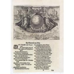
Americae Retectio (Allegory of the Discovery of America)
Allegorical scene commemorating the discovery of America. The main image shows Neptune, supporting a Globe, flanked by Flora-representing Florence, and Janus-representing...
Date: Frankfurt, 1594
Selling price: ????
Please login to see price!
Sold in 2015
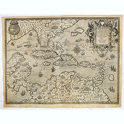
Occidentalis Americae partis.
The most beautifully engraved early map of the Caribbean, including Florida and the South-east. The map includes representations of Columbus' ships and various notes rega...
Date: Frankfurt, 1594
Selling price: ????
Please login to see price!
Sold
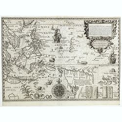
Insulae Moluccae celeberrimæ sunt ob Maximam aromatum copiam quam per totum terrarum orbem mittunt...
FIRST EDITION, engraved by Johannes à Doeticum c.1594. Very rare key map showing Southeast Asia with the Sunda Islands, the Moluccas, and much of the mainland coast well...
Date: Amsterdam,1592-1594
Selling price: ????
Please login to see price!
Sold in 2018
Occidentalis Americae partis..
The most beautifully engraved early map of the Caribbean, including Florida and the Southeast. The map includes representations of Columbus' ships and various notes regar...
Date: Frankfurt 1594
Selling price: ????
Please login to see price!
Sold in 2019
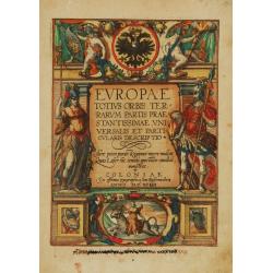
Title page : Europae totius orbis terrarum partis praestantissimae ..
Quad's title page of his rare work Europae totius orbis terrarum partis praestantissimae..Engraved by Henricus Nagel. Latin text on verso.
Date: Cologne 1594
Selling price: ????
Please login to see price!
Sold
Americae sive novi orbis, nova descriptio.
In 1587, a new plate was engraved which appeared in editions from 1588 onwards. Of the three maps, this one is perhaps the most important. It is the most geographically a...
Date: Antwerp 1595
Selling price: ????
Please login to see price!
Sold
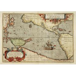
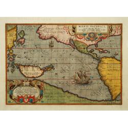
Maris Pacifici.
"This was the first printed map to be devoted solely to the Pacific, and the first to name North and South America separately. It includes most of North and South Am...
Date: Antwerp 1595
Selling price: ????
Please login to see price!
Sold
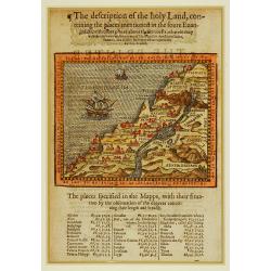
The description of the holy Land, conteining the places..
Description of the Holy Land, showing all the places mentioned in the Gospels and the itineraries of Jesus Christ and his disciples in Judea, Samaria, and Galilee. Shows ...
Date: London 1595
Selling price: ????
Please login to see price!
Sold
Africae propriae Tabula..
The most beautiful early map of the northern coast of Africa that is available to the collector. Prepared by Ortelius himself based on modern information from Gastaldi's ...
Date: Antwerp 1595
Selling price: ????
Please login to see price!
Sold
Daphne.
Made by Ortelius on the basis of information from ancient sources, specifically Ammianus, Strabo and Philostratus.This is the depiction of the Paradise Daphne, a pleasant...
Date: Antwerp, 1595
Selling price: ????
Please login to see price!
Sold in 2011
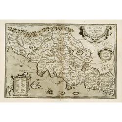
Tusciae Antiquae Typus.
Based on Bellarmati's map of Tuscany, supplemented by classical sources, viz. Livius, Plinius, Cato, Virgil, Halicarnassaeus and Plutarchus.This map belongs to a series o...
Date: Antwerp 1595
Selling price: ????
Please login to see price!
Sold
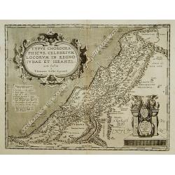
Typus chorographicus, celebrium locoum in regno Judae et..
Drawn by Tilemannus Stella Sigenensi, this map delineates the most important places in the kingdom of Judah and Israel. The shore lines runs from Berytus (Beirut) to Rhin...
Date: Antwerp 1595
Selling price: ????
Please login to see price!
Sold
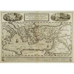
Peregrinationis Divi Pauli Typus?
A splendid map depicting the travels of Paulus. With two fine scenes in top. Showing the countries along the Mediterranean, including Cyprus and Italy. Based on Mercator'...
Date: Antwerp 1595
Selling price: ????
Please login to see price!
Sold in 2008
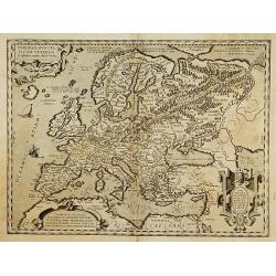
Europam, Sive Celticam Veterem.
Possibly derived to some extent from Ortelius' own two sheet map of the Roman Empire, which appeared in 1571. Further, this map is based on classical sources, such as Sal...
Date: Antwerp 1595
Selling price: ????
Please login to see price!
Sold
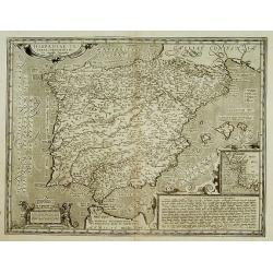
Hispaniae Veteris descriptio.
Made on the basis of modern information from Clusius' six-sheet map of Spain which appeared in 1571 and ancient knowledge from Strabo, Appianus, Bongarius, Livius, Valeri...
Date: Antwerp 1595
Selling price: ????
Please login to see price!
Sold
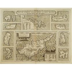
Insular. Aliquot Aegaei Maris Antiqua Descrip.
Ten maps on one plate. Showing Rinia and Dilos, Nicaria, Euboea, Samos, Keos (near Euboea), Rhodus, Chios, Cyprus, Lesbos, Lemnos.This map belongs to a series of historic...
Date: Antwerp 1595
Selling price: ????
Please login to see price!
Sold
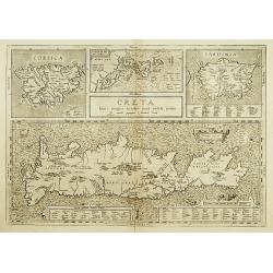
Creta Iouis magni../Corsica../ Sardinia..
Islands are shown with place names and important locales as they existed in the Classical Period. Ortelius mentions as his classical sources Strabo, Palenses, Athenaeus, ...
Date: Antwerp 1595
Selling price: ????
Please login to see price!
Sold
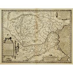
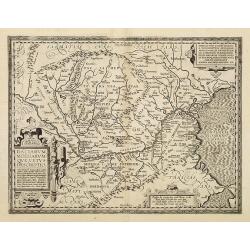
Daciarum, Moesiarumque, Vetus descriptio.
Decorative ancient map of Hungary. From his historical atlas including a series of maps prepared by Ortelius himself.Signed lower left hand corner Ex conatibus Abrahami O...
Date: Antwerp 1595
Selling price: ????
Please login to see price!
Sold
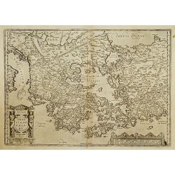
Graeciae Sophiani.
This is a beautiful depiction of ancient Greece. The map has a beautiful title cartouche in the shape of a Grecian temple in the bottom left-hand corner and a large scale...
Date: Antwerp 1595
Selling price: ????
Please login to see price!
Sold
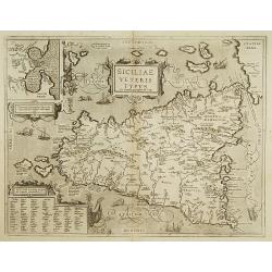
Siciliae Veteris Typus.
A very beautiful early map of ancient Sicily. Title cartouche centred on the upper part: includes also an inset map of Syracuse in the upper left, and a list of the towns...
Date: Antwerp 1595
Selling price: ????
Please login to see price!
Sold
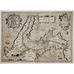
Graecia Maior.
Based on classical authors sources. With inset map: I. di Tremite (actually located just outside the lower left corner of the map), belonged to the Kingdom of Naples, and...
Date: Antwerp 1595
Selling price: ????
Please login to see price!
Sold
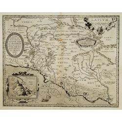
Latium.
Based on classical authors sources, specifically Virgilius, Plinius, Varro, Halicarnasseus, Festus and Ausonius.Philip Wingius in his letter to Ortelius from 1592 mention...
Date: Antwerp 1595
Selling price: ????
Please login to see price!
Sold
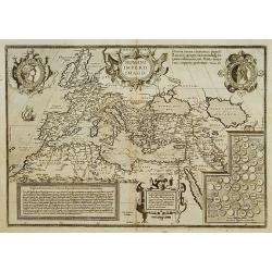
ROMANI IMPERII IMAGO.
The medallion portraits are of Romulus and Remus -the genealogical 'tree' describes the lineage of the Roman emperors while the strapwork bordered panels explain the hist...
Date: Antwerp 1595
Selling price: ????
Please login to see price!
Sold
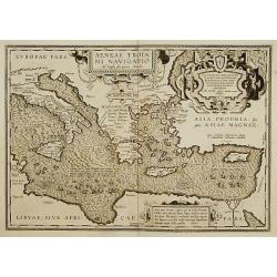
Aeneae Troiani navigatio..
After the destruction of Troy, Aenaeas is reported to have roamed the seas for seven years, as described in the writings of Xenophon, Ovidius, Lycrophonous, but most exte...
Date: Antwerp 1595
Selling price: ????
Please login to see price!
Sold
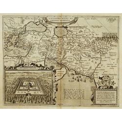
Alexandri Magni Maredonis Expeditio.
Handsomely engraved map of Alexander the Great's Empire at full flower, with a large inset depicting the Temple of the Oracle of Jupiter Amman, supposedly situated in pre...
Date: Antwerp 1595
Selling price: ????
Please login to see price!
Sold
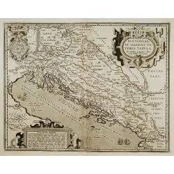
Pannoniae, et Illyrici Veteris Tabula.
Made on the basis of Gastaldi's 1560 map of South East Europe and on information from ancient sources, specifically Plinius, Livius, Bonfinius, Dionus and Aurelius Victor...
Date: Antwerp 1595
Selling price: ????
Please login to see price!
Sold
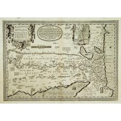
Aegyptus Antiqua.
A splendid map of ancient Egypt, which appeared in Ortelius' Parergon. The map is based on his separately published map of Egypt, published in 1565, but with differences ...
Date: Antwerp 1595
Selling price: ????
Please login to see price!
Sold
Hispaniae Veteris descriptio.
Made on the basis of modern information from Clusius' six-sheet map of Spain which appeared in 1571 and ancient knowledge from Strabo, Appianus, Bongarius, Livius, Valeri...
Date: Antwerp 1595
Selling price: ????
Please login to see price!
Sold
Exacta & accurata.. regionibus China, Cauchinchina, Camboja..
...the Far East and the Malay Archipelago are represented in such detail as was known only to the Portuguese at that time and had never before shown on a printed map. (S...
Date: Amsterdam 1595
Selling price: ????
Please login to see price!
Sold
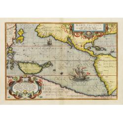
Maris Pacifici.
This was the first printed map to be devoted solely to the Pacific, and the first to name North and South America separately. Lower right a large presentation of Ferdinan...
Date: Antwerp, 1595
Selling price: ????
Please login to see price!
Sold in 2016
Hispaniae Novae.
This was the standard map of the area for a generation, copied by De Bry, Quad and Hondius. Even though Herrera (Spain's Royal Cosmographer) and Wytfliet worked 20 years ...
Date: Antwerp 1595
Selling price: ????
Please login to see price!
Sold
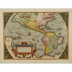
Americae sive novi orbis, nova descriptio.
In 1587, a new plate was engraved which appeared in editions from 1588 onwards. Of the three maps, this one is perhaps the most important. It is the most geographically a...
Date: Antwerp 1595
Selling price: ????
Please login to see price!
Sold
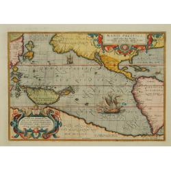
Maris Pacifici.
This was the first printed map to be devoted solely to the Pacific, and the first to name North and South America separately. It includes most of North and South America,...
Date: Antwerp 1595
Selling price: ????
Please login to see price!
Sold
Americae sive novi orbis, nova descriptio.
In 1587, a new plate was engraved which appeared in editions from 1588 onwards. Of the three maps, this one is perhaps the most important. It is the most geographically a...
Date: Antwerp 1595
Selling price: ????
Please login to see price!
Sold
Maris Pacifici.
This was the first printed map to be devoted solely to the Pacific, and the first to name North and South America separately. It includes most of North and South America,...
Date: Antwerp 1595
Selling price: ????
Please login to see price!
Sold
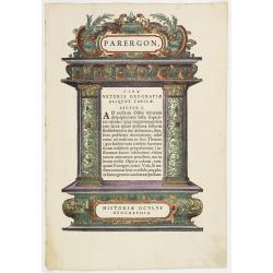
Titlepage: Parergon, in quo Veteris geographiae aliquot tabulae.
Title page to the section of the Ortelius atlas part, Parergon with original hand-colored decoration. The printer Plantin originally used the wood block for the first pag...
Date: Antwerp 1595
Selling price: ????
Please login to see price!
Sold
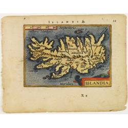
Islandia.
Miniature map Island. From the second series of miniature atlas of Ortelius' Epitome. A new series of pocket-size atlases was begun by Philip Galle in 1588. It seems that...
Date: Antwerp 1595
Selling price: ????
Please login to see price!
Sold
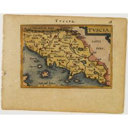
Tuscia.
Miniature map of Tuscany. From the second series of miniature atlas of Ortelius' Epitome. A new series of pocket-size atlases was begun by Philip Galle in 1588. It seems ...
Date: Antwerp 1595
Selling price: ????
Please login to see price!
Sold
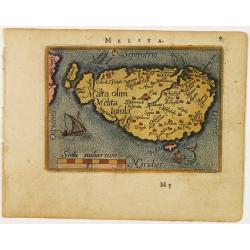
Malta olim Melita Insula.
Miniature map of Malta. From the second series of miniature atlas of Ortelius' Epitome. A new series of pocket-size atlases was begun by Philip Galle in 1588. It seems th...
Date: Antwerp 1595
Selling price: ????
Please login to see price!
Sold
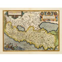
Terra Sancta.
This is the most modern of Ortelius' maps of the Holy Land. It focuses specifically on the Holy Land and is oriented with east of the top. Ortelius used as a model the wa...
Date: Antwerp, 1595
Selling price: ????
Please login to see price!
Sold in 2022
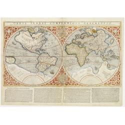
Orbis Terrae Compendiosa Descriptio.
The rare early edition with text underneath the map. Gerard Mercator's great world map of 1569 was condensed into double hemispherical form by his son Rumold. It first ap...
Date: Amsterdam 1595
Selling price: ????
Please login to see price!
Sold
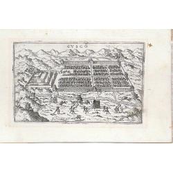
Cusco
Miniature town view of the City of Cuzco, Peru, with figures in the foreground Valegio signature at the lower edge of the plate. It was published as part of a series of b...
Date: Venice, 1595
Selling price: ????
Please login to see price!
Sold in 2016
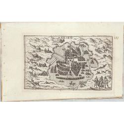
Mexico
Miniature map of Mexico city.
Date: Venice, 1595
Selling price: ????
Please login to see price!
Sold in 2014
Hispaniae Veteris descriptio.
Based on Clusius' six-sheet map of Spain appeared in 1571 and knowledge from Strabo, Appianus, Bongarius, Livius, Valerius Maximus, and Suetonius.This map belongs to the ...
Date: Antwerp, 1595
Selling price: ????
Please login to see price!
Sold in 2013
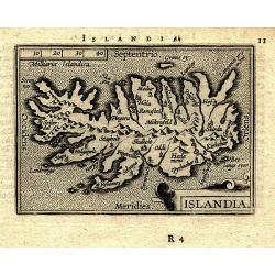
ISLANDIA.
Superb miniature map of Iceland. From the second series of the miniature atlas of Ortelius' Epitome. Shows the island with the main towns, mountains, rivers, and islands....
Date: Antwerp, 1595
Selling price: ????
Please login to see price!
Sold in 2009
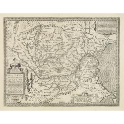
Daciarum, Moesiarumaue Vetus Descriptio.
Decorative map of ancient Hungary. From his historical atlas including a series of maps prepared by Ortelius himself. Signed lower left hand corner Ex conatibus Abrahami ...
Date: Antwerp, 1595
Selling price: ????
Please login to see price!
Sold in 2009
![[Von der Landtschafft Iudaea]](/uploads/cache/90956-250x250.jpg)
[Von der Landtschafft Iudaea]
16th century woodcut view of Jerusalem on the full folio sheet. From "Theatrum Urbium" by Abraham Saur printed in Frankfurt 1595 by N. Basseus.
Date: Frankfurt, 1595
Selling price: ????
Please login to see price!
Sold in 2010
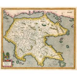
Morea olim Peloponnesus.
Peloponnisos by Mercator. Latin text on verso.
Date: Amsterdam, 1595
Selling price: ????
Please login to see price!
Sold in 2009
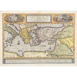
Peregrinationis Divi Pauli Typus Corographicus . . .
A splendid map depicting the travels of Paulus. With two fine scenes in top. Showing the countries along the Mediterranean, including Cyprus and Italy. Based on Mercator'...
Date: Antwerp, 1595
Selling price: ????
Please login to see price!
Sold
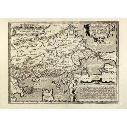
Natoliae, quae olim Asia Minor Nova Descriptio - Aegypti Recentior Descriptio - Carthaginis Celeberrimi Sinus Typus
colored copper engraved map of Turkey by A. Ortelius. On right side a map of Egypt and one of Tunis. Three map on one sheet printed from one plate. From the 1595 Latin ed...
Date: Antwerp, 1595
Selling price: ????
Please login to see price!
Sold in 2010
Thraciae veteris typus
Decorative map of the western part of Turkey by A. Ortelius. Showing the Dardanelles, the Sea of Marmara with the Bosporus and Istanbul. From the 1595 Latin edition of 'T...
Date: Antwerp, 1595
Selling price: ????
Please login to see price!
Sold in 2013
Flandriae Comitatus Descripto.
Colorful map of Belgium focuses on Flanders, the Dutch speaking region in northern Belgium, after Gerard Mercator. Many major cities and religious centers, including Ghen...
Date: Amsterdam, 1595
Selling price: ????
Please login to see price!
Sold in 2010
Daciarum, Moesiarumaue Vetus Descriptio.
Decorative map of ancient Hungary. From his historical atlas including a series of maps prepared by Ortelius himself. Signed lower left hand corner Ex conatibus Abrahami ...
Date: Antwerp, 1595
Selling price: ????
Please login to see price!
Sold in 2010
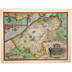
Artois. Atrebatum Regionis Vera Descriptio.
Map of Artois, a former province at the northwest tip of France, by Abraham Ortelius. Accompanying Latin text with hand-colored rubric letters on verso. Vibrant, original...
Date: Antwerp, c.1595
Selling price: ????
Please login to see price!
Sold in 2010
Hispaniae Veteris descriptio.
Made on the basis of modern information from Clusius' six-sheet map of Spain which appeared in 1571 and ancient knowledge from Strabo, Appianus, Bongarius, Livius, Valeri...
Date: Antwerp, 1595
Selling price: ????
Please login to see price!
Sold in 2011
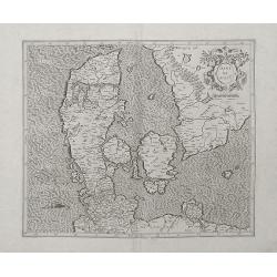
Daniae Regnu.
An uncolored example of Mercator's first map of Denmark, from the first edition of his Atlas.A decorative map of Denmark by Gerard Mercator himself., with an ornate strap...
Date: Amsterdam, 1595
Selling price: ????
Please login to see price!
Sold in 2012
Hispaniae nova describtio. . .
Map of Spain and Portugal. Engraved by Petrus Kaerius.
Date: Amsterdam, 1595
Selling price: ????
Please login to see price!
Sold in 2011
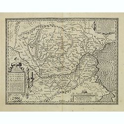
Daciarum, Moesiarumaue Vetus Descriptio.
Decorative map of ancient Hungary. From his historical atlas including a series of maps prepared by Ortelius himself. Signed lower left hand corner Ex conatibus Abrahami ...
Date: Antwerp, 1595
Selling price: ????
Please login to see price!
Sold in 2011
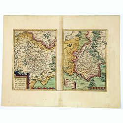
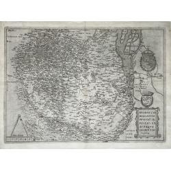
Turingiae Noviss. Descript. / Misniae et Lusatiae Tabula.
A delightful pair of central German maps of Thuringia & Meissen, by Ortelius, published in Antwerp towards the end of the sixteenth century. The left hand map is that...
Date: Antwerp, ca 1595
Selling price: ????
Please login to see price!
Sold in 2020
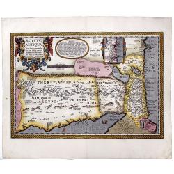
AEGYPTUS ANTIQUA. Terra suis contante bonis, non indiga mercis. . .
A splendid map of ancient Egypt, which appeared in Ortelius' Parergon. The map is based on his separately published map of Egypt, published in 1565, but with differences ...
Date: Antwerp, 1595
Selling price: ????
Please login to see price!
Sold in 2020
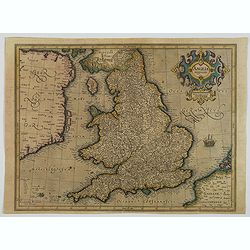
Anglia regnum.
A finely engraved map of England published during the last years of the reign of Elizabeth I, filled with names taken from the earlier Christopher Saxton map of 1579. Wit...
Date: Duisburg, ca 1595
Selling price: ????
Please login to see price!
Sold in 2023
Brabantiae Belgarum Provinciae Exactaque Descriptio.
A very rare Brabant map, Netherlands, Belgium, Brabant; by Gerard de Jode - Brabantiae Belgarum Provinciae recens exactaque descriptio - 1595.Orientation: is West upwards...
Date: Antwerp, 1595
Selling price: ????
Please login to see price!
Sold in 2021
![[Map of Switzerland canton of Argow.]](/uploads/cache/47450-250x250.jpg)
[Map of Switzerland canton of Argow.]
Map of Argow. With his engraved signature lower left.
Date: Amsterdam, ca. 1595
Selling price: ????
Please login to see price!
Sold in 2021
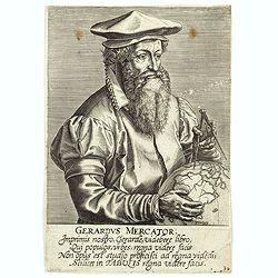
Gerardus Mercator Imprimis nostro
Portrait of Gerard Mercator taken from " Imagines L. doctorum virorum Galle, P. Imagines L. doctorum virorum, qui bene de studiis literarum merure, cum singulorum el...
Date: Antwerp, 1595
Selling price: ????
Please login to see price!
Sold in 2023