Browse Listings
![[4-sheets] Wales.](/uploads/cache/39117-250x250.jpg)
[4-sheets] Wales.
Large four-sheet map of Wales by Edward Weller, published in the 'Dispatch Atlas'.Map consists of a N.E. sheet, from Montgomeryshire up to the River Dee, a S.E. sheet fro...
Date: London, 1863
Selling price: ????
Please login to see price!
Sold in 2017
![[4-sheets] Scotland.](/uploads/cache/39118-250x250.jpg)
[4-sheets] Scotland.
Large four-sheet map of Scotland by Edward Weller, published in the 'Dispatch Atlas'.Map consists of a N.W. sheet, from, the Western Isles, Skye, to parts of Ross and Sut...
Date: London, 1863
Selling price: ????
Please login to see price!
Sold in 2017
![[4-sheets] England and Wales.](/uploads/cache/39119-250x250.jpg)
[4-sheets] England and Wales.
Large four-sheet map of England and Wales by Edward Weller, published in the 'Dispatch Atlas'.Map consists of a S.E. sheet, showing London and the 'Home Counties', a S.W....
Date: London, 1863
Selling price: ????
Please login to see price!
Sold in 2017
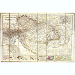
Der Osterreichische Kaiserstaat Entworfen von Herm. Berghaus. . .
Very detailed large-scale 19th century folding map of Austria, published in the birth year of Franz Ferdinand, became Archduke of Austria. Covers from Northern part of It...
Date: Gotha, Justus Perthes, 1863
Selling price: ????
Please login to see price!
Sold in 2023
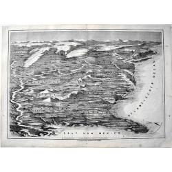
Die Vereinigten Staaten von Amerika aus der Vogelschau.
From the "Illustrierte Zeitung", a rere map of the United States appeared in 1863. It shows the "sclaven Staaten" as well as the train roads. Rare
Date: Germany, 1863
Selling price: ????
Please login to see price!
Sold in 2017

La Basse-Terre, vue prise de la Batterie de l'Impératrice, (Guadeloupe).
A fantastic view of the town from the rare and important series La Guadeloupe pittoresque by Armand Budan, published in 1863. Lithograph by Emile Vernier, and printed by...
Date: Paris, 1863
Selling price: ????
Please login to see price!
Sold in 2017

Le Bourg de L'Anse Bertrand. Grand Terre (Guadeloupe).
A fantastic view of Anse-Bertrand, from the rare and important series La Guadeloupe pittoresque by Armand Budan, published in 1863. Lithograph by Emile Vernier, and print...
Date: Paris, 1863
Selling price: ????
Please login to see price!
Sold in 2020

Vue du port et de la ville du Moule.
A fantastic view of Le Moule, from the rare and important series La Guadeloupe pittoresque by Armand Budan, published in 1863. Lithograph by Emile Vernier, and printed by...
Date: Paris, 1863
Selling price: ????
Please login to see price!
Sold in 2020

Vue de la Souffrière prise de Versailles (Guadeloupe).
A fantastic view of the Soufrière volcano ,taken from the rare and important series La Guadeloupe pittoresque by Armand Budan, published in 1863. Lithograph by Emile Ver...
Date: Paris, 1863
Selling price: ????
Please login to see price!
Sold in 2020
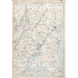
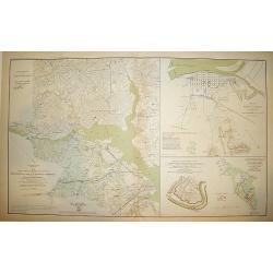
Seat of war in Virginia and Maryland.
An important and very detailed map of the District of Columbia, Eastern Maryland and Virginia. Extends from Gettysburg to Fredericksburg and Leonardtown, and includes str...
Date: London, ca. 1863
Selling price: ????
Please login to see price!
Sold in 2018
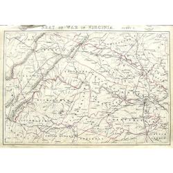
Seat of War in Virginia. Sheet 3.
An important and very detailed map of a part of Virginia. With Richmond, Staunton, Charlottesville, Lynchburg, etc, that includes streets, railroads, towns, rivers, and m...
Date: London, ca. 1863
Selling price: ????
Please login to see price!
Sold in 2018
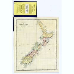
The Islands of New Zealand.
A lovely folding map of New Zealand, complete within its original blue boards, with original affixed yellow and black printed label. Inside cover has general information ...
Date: London, ca 1863
Selling price: ????
Please login to see price!
Sold in 2018
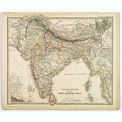
Vorder-Indien oder das Anglo-Indische Reich.
This is a nice example of Stieler's 1863 map of the Indian subcontinent. It covers from the Himalayas in the north as far south as Ceylon (Sri Lanka), and from Sindh in t...
Date: Gotha, 1863
Selling price: ????
Please login to see price!
Sold in 2020
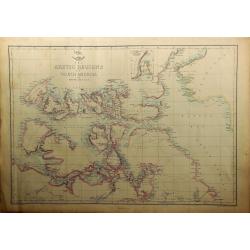
The Arctic Regions of North America.
A highly detailed map of the far north of America from Bankes Strait through Baffin Bay, by Edward Weller, for the Weekly Dispatch Atlas. With an inset "Continuation...
Date: London, 1863
Selling price: ????
Please login to see price!
Sold in 2019
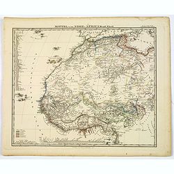
Mittel und Nord-Africa. Westl. Theil.
An informative and detailed map of middle, western and northern Africa, published in Gotha by Perthes in Stieler's Hand Atlas in 1863. It shows elevations, cities, tracks...
Date: Gotha, 1863
Selling price: ????
Please login to see price!
Sold in 2019
![[Game of the goose dedicated to horse racing]](/uploads/cache/43905-250x250.jpg)
[Game of the goose dedicated to horse racing]
Game of 100 boxes, spiral, counter clockwise, centripetal, dedicated to horse racing. The example was made by "Imagerie d'Epinal" and next to the title is "...
Date: Epinal, 1863
Selling price: ????
Please login to see price!
Sold in 2020
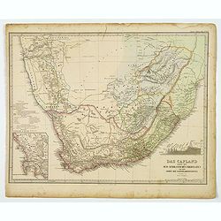
Das Capland nebst den Sud-Afrikanischen Freistaaten und dem gebeit der Kaffern & Hottentotten.
A detailed German map of South Africa, published during the second half of the 19th century. Coastal detail is very good with many place names, bays and points identified...
Date: Gotha, 1863
Selling price: ????
Please login to see price!
Sold in 2021
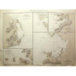
![Coast of China [2 maps].](/uploads/cache/45479-250x250.jpg)
Coast of China [2 maps].
A pair of Chinese coastal maps: The first from Nyew Tew Island to Hae-Chow. The second from Hae-Chow to Leaotong Gulf. Both show depth soundings, numerous bays and inlets...
Date: London, ca 1863
Selling price: ????
Please login to see price!
Sold in 2023
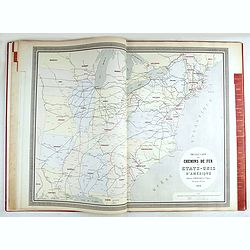
Atlas des Chemins de Fer.
Fine and curious atlas showing the rail road systems of France, Europe, England, United States, Russia, Germany, Italy, Spain, Algeria and the different regions in France...
Date: Paris, 1863
Selling price: ????
Please login to see price!
Sold in 2023
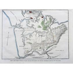
Map of the country between Auckland and the River Waikato, New Zealand, illustrating the war with the natives.
A scarce map illustrating the Land Wars between settlers in New Zealand and Maori people. It shows the area from Auckland until the Waikato River with interesting detail...
Date: London, 1863
Selling price: ????
Please login to see price!
Sold in 2021

Atlas des Chemins de Fer.
Fine and curious atlas showing the rail road systems of France, Europe, England, United States, Russia, Germany, Italy, Spain, Algeria and the different regions in France...
Date: Paris 1863
Selling price: ????
Please login to see price!
Sold
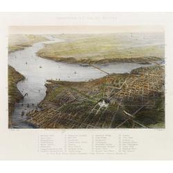
Washington D.C. and its Vicinity.
Bird's eye-view. With a numbered key 1-33 for points of interest. Engraved by W. Ridgway after J. Wells.
Date: New York, ca. 1863
Selling price: ????
Please login to see price!
Sold

DISASTROS.
Fr.Goya y Lucientes (1746-1828), from the series "Disastros": "y no had remedios", from the 1st edition of Desastros, Madrid 1863.Original etching and...
Date: Madrid 1863
Selling price: ????
Please login to see price!
Sold
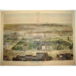
WASHINGTON CITY, D.C.
An impressive wood-cut panorama of Washington D.C, as seen during the middle of the American Civil War. The view centers on the White House, Patent Office and Post Office...
Date: New York, 1863
Selling price: ????
Please login to see price!
Sold
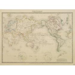
The world on Mercators projection.
Very detailed map of the world, centred on Australia. Inset maps of north and south pole.James Wyld (the younger) was geographer to the Queen and H.R.H. Prince Albert. Jo...
Date: London 1855/1863
Selling price: ????
Please login to see price!
Sold
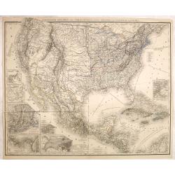
Vereinigte Staaten von Nord Amerika, nebst Mexico..
Uncommon map United States, with inset maps of San Francisco, German settlement Wartburg near Kingston, New England, Panama, New York, and Boston, including the Great Lak...
Date: Leipzig, 1863
Selling price: ????
Please login to see price!
Sold in 2018
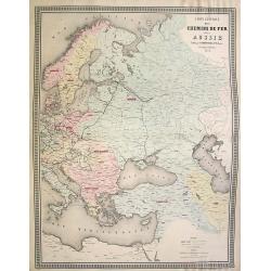
Carte generale des Chemins de fer de la Russie..
Fine map of Russia, Scandinavia, Germany, showing the early railway system of the area. From Atlas des Chemins de Fer published by Napoléon Chaix and printed by Imprimer...
Date: Paris 1863
Selling price: ????
Please login to see price!
Sold in 2008
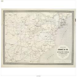
Nouvelle carte des chemins de fer des Etats-Unis d'Amerique
Fine map of eastern part of the United States, showing the early railway system of the area. From Atlas des Chemins de Fer published by Napoléon Chaix and printed by Imp...
Date: Paris 1863
Selling price: ????
Please login to see price!
Sold in 2011
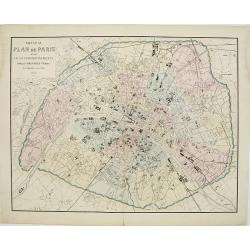
Nouveau Plan de Paris divisé en 20 arrondissements.
Detailed plan of Paris and its 20 arrondissements. Also shown are the railway system of the city with its railway stations.From Atlas des Chemins de Fer published by Napo...
Date: Paris 1863
Selling price: ????
Please login to see price!
Sold in 2010
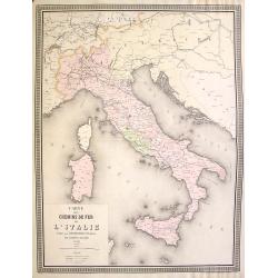
Carte des chemins de fer de l'Italie.
Detailed map of Italy, Sicily, Corsica and Sardinia. Shown are the railway systems of the country at an early stage.From Atlas des Chemins de Fer published by Napoléon C...
Date: Paris 1863
Selling price: ????
Please login to see price!
Sold in 2021
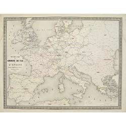
Nouvelle carte des chemins de fer de Europe.
Detailed map of Europe showing its railway systems at this early stage.From Atlas des Chemins de Fer published by Napoléon Chaix and printed by Imprimerie et librairie c...
Date: Paris 1863
Selling price: ????
Please login to see price!
Sold in 2011
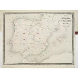
Carte des chemins de fer de l'Espagne et du Portugal. . .
Fine map of Spain and Portugal, showing the early railway system of the area. From Atlas des Chemins de Fer published by Napoléon Chaix and printed by Imprimerie et libr...
Date: Paris, 1863
Selling price: ????
Please login to see price!
Sold in 2011
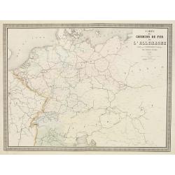
Carte des Chemins de Fer de l'Allemagne.
Fine map of Germany, The Netherlands and Eastern Europe, showing the early railway system of the area. From Atlas des Chemins de Fer published by Napoléon Chaix and pri...
Date: Paris, 1863
Selling price: ????
Please login to see price!
Sold in 2011
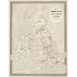
Nouvelle Carte des Chemins de Fer de la Grande Bretagne et de l'Irlande. . .
Fine map of England, Scotland and Ireland showing the early railway system of the area.From Atlas des Chemins de Fer published by Napoléon Chaix and printed by Imprimeri...
Date: Paris, 1863
Selling price: ????
Please login to see price!
Sold in 2011
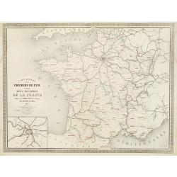
Carte Générale des Chemins de Fer et des Voies Navigables de la France.
Fine map of France, showing the early railway system of the area as well as the navigable rivers and canals.With inset map of the surrounding area of Paris in the lower l...
Date: Paris, 1863
Selling price: ????
Please login to see price!
Sold in 2011
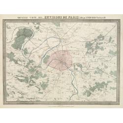
Nouvelle Carte des Environs de Paris.
Fine map of Paris and its contiguous outskirts, showing the early railway system of the area.From Atlas des Chemins de Fer published by Napoléon Chaix and printed by Imp...
Date: Paris, 1863
Selling price: ????
Please login to see price!
Sold in 2011
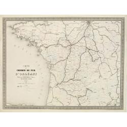
Carte du Chemin de Fer d'Orléans..
Fine map showing the early railway system of a large area extending westwards and southwards from Paris.From Atlas des Chemins de Fer published by Napoléon Chaix and pri...
Date: Paris 1863
Selling price: ????
Please login to see price!
Sold in 2011
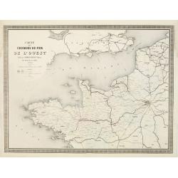
Carte des Chemins de Fer de l'Ouest..
Fine map showing the early railway system of a large area extending westwards from Paris as far as the coasts of Brittany.It includes part of the northern regions and the...
Date: Paris 1863
Selling price: ????
Please login to see price!
Sold
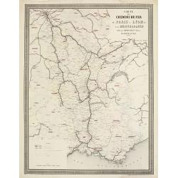
Carte des Chemins de Fer de Paris à Lyon et à la Méditerranée.
Fine map showing the early railway system of a large area extending from Paris to South East France.From Atlas des Chemins de Fer published by Napoléon Chaix and printed...
Date: Paris 1863
Selling price: ????
Please login to see price!
Sold in 2011
Küstenansichten eines Theiles der Insel NIPPON..
Prepared by Officer S.M.S. Arcona during the German expedition of 1860-1861 to South East Asia. Lithographed by Lippold and printed by C.Ulrich of Berlin. Sheet 1 from a ...
Date: Berlin, 1863
Selling price: ????
Please login to see price!
Sold in 2013
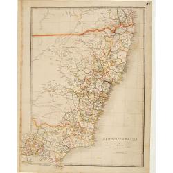
New South Wales. . .
Very detailed map of New South Wales. The gold deposits are marked in yellow.James Wyld (the younger) was geographer to the Queen and H.R.H. Prince Albert. Joined his fat...
Date: London 1855/1863
Selling price: ????
Please login to see price!
Sold in 2010
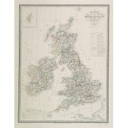
Map of the United Kingdom of Great Brittain and Ireland.
Very detailed map of Great Britain and Ireland. Lower left statistic table and upper left inset map of Shetland Islands.James Wyld (the younger) was geographer to the Que...
Date: London, 1863
Selling price: ????
Please login to see price!
Sold in 2009
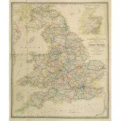
A Map of England, Wales & Scotland..
Very detailed map of England, Wales and Scotland. In upper right hand corner inset map of northern part of Scotland.James Wyld (the younger) was geographer to the Queen a...
Date: London, 1863
Selling price: ????
Please login to see price!
Sold in 2023

(Vereinigte Staaten von Nord Amer)ika, nebst Mexico und Central America
The right hand part of an uncommon map of the United States, German settlement Wartburg near Kingston, inset plan of Boston, including the Great Lakes area. With color-ke...
Date: Leipzig, 1863
Selling price: ????
Please login to see price!
Sold in 2011
Russland.
This is a rare decorative map of Russia with informative borders, published in Brockhaus' Illustrierter Handatlas .
Date: Leipzig, 1863
Selling price: ????
Please login to see price!
Sold in 2011
Afrika nach den neuesten Entdeckungen
A ''smaller'' Stieler map no 27, from his atlas for schools. About 8x10 inches. Unusual version as the cartouche is not in the usual circle upper right corner, but has be...
Date: Gotha/Perthes 1864
Selling price: ????
Please login to see price!
Sold
A map of Australia..
Very detailed map of Australia with inset maps of Van Diemen Land and a world map in Mercator projection, centered on Australia.James Wyld (the younger) was geographer to...
Date: London, 1855/1864
Selling price: ????
Please login to see price!
Sold in 2008
Map of India. . .
Very detailed road, railway and telegraphic map of India showing the post roads. With color key to British possessions, independent-, protected- and subsidiary states. Se...
Date: London, 1855/1864
Selling price: ????
Please login to see price!
Sold
Map of the countries inbetween England & India..
Very detailed map of the countries between England and India, designed to show the over-land and sea routes to the East. In lower left-hand corner inset map of the easter...
Date: London, 1855/1864
Selling price: ????
Please login to see price!
Sold
To the right.. this chart of New Zealand..
Very detailed map of New Zealand, with inset maps of entrance of the Hokianga River, Southern Port of Stewart's Island, plan of Dusky Bay, Port Nicocholson and a plan of ...
Date: London 1864
Selling price: ????
Please login to see price!
Sold
Nouveau planisphère présentant toutes les découvertes dans les mers polaires.
Attractive world map showing the Western Hemisphere with the America's depicted in fine detail and all the islands in the Pacific Ocean including the Sandwich Islands (Ha...
Date: Paris, 1864
Selling price: ????
Please login to see price!
Sold
A new map of Sweden and Norway.
Very detailed map of Sweden, Norway, Denmark and Finland. Indicated are railways and Canals.James Wyld (the younger) was geographer to the Queen and H.R.H. Prince Albert....
Date: London, 1855/1864
Selling price: ????
Please login to see price!
Sold in 2018
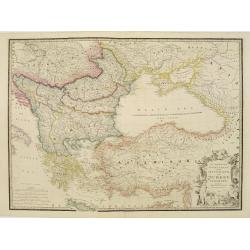
European Dominions of the Ottomans or Turkey in Europe..
Very detailed map of Turkey, Greece and the Black Sea. Northern part of Cyprus is included. Railways indicated.James Wyld (the younger) was geographer to the Queen and H....
Date: London, 1855/1864
Selling price: ????
Please login to see price!
Sold in 2009
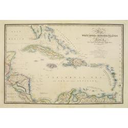
Map of the West India & Bahama Islands..
Very detailed map of the Caribbean, including Southern tip of Florida, Bahamas' Islands, north coast of Venezuela and Honduras.James Wyld (the younger) was geographer to ...
Date: London, 1855/1864
Selling price: ????
Please login to see price!
Sold in 2017
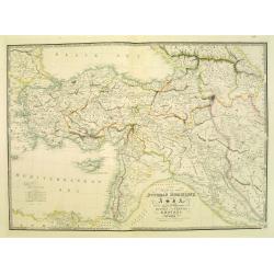
Map of the Ottoman Dominions in Asia. . .
Very detailed map of Turkey, Palestine, Azerbijan, Kurdistan, Georgia and Cyprus.James Wyld (the younger) was geographer to the Queen and H.R.H. Prince Albert. Joined his...
Date: London, 1855/1864
Selling price: ????
Please login to see price!
Sold in 2009
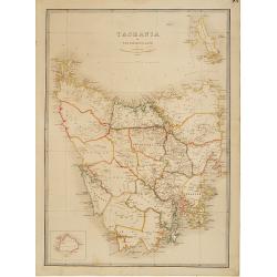
Tasmania or Van Diemens Land. . .
Very detailed map of Tasmania with inset map of Kings Island.James Wyld (the younger) was geographer to the Queen and H.R.H. Prince Albert. Joined his father's business i...
Date: London 1855/1864
Selling price: ????
Please login to see price!
Sold in 2012
Ports dans le Canal Kii (Japon).
Rare Admiralty Chart with 5 large scale maps on one sheet: Shows the harbour of Jura; the Hachken river, Yura No Uchi, Bay of Tanabe, Bay of Osaki.All 5 charts with much ...
Date: Paris, 1864
Selling price: ????
Please login to see price!
Sold in 2011
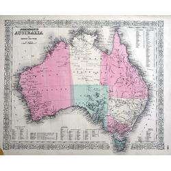
Johnson's Australia by Johnson and Ward.
A decorative map of Australia surrounded with Johnson's strapwork border. Very detailed map with many place names, even in the interior. With tables containing reference...
Date: New York, c1864
Selling price: ????
Please login to see price!
Sold in 2012

Nangasaki.
A fine bird's-eye view showing Deshima (the head quarter of the V.O.C.) and Nagasaki bay. From Die Preussische Expedition nach Ost Asien . With many European ships in the...
Date: Berlin, 1864
Selling price: ????
Please login to see price!
Sold in 2015

Johnson's China.
Very detailed map of China. Includes Formosa (Taiwan) and Korea. With an inset map of Canton area including Hong Kong; and a second inset map of Amoy (Xiamen) Island. ...
Date: New York, 1864
Selling price: ????
Please login to see price!
Sold in 2012
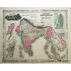
Johnson's Hindostan or British India.
Attractive steel engraved map, extending from the Indus River eastwards with India, Burma, Siam (Thailand), Laos, Cambodia, Malaysia (Malacca), Singapore, and Vietnam (To...
Date: New York, 1864
Selling price: ????
Please login to see price!
Sold in 2012
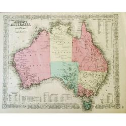
Johnson's Australia by Johnson and Ward.
A decorative map of Australia surrounded with Johnson's strapwork border. Very detailed map with many place names, also in the interior. With tables containing reference...
Date: New York, c1864
Selling price: ????
Please login to see price!
Sold in 2012
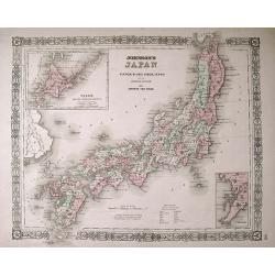
Johnson's Japan; Nippon, Kiusiu, Sikok, Yesso and the Japanese Kuriles.
An attractive map with insets of Yesso and the Japanese Kuriles, and the Bay of Nagasaki. The detailed map was compiled from the maps of Siebold and the surveys of the U....
Date: New York, c1864
Selling price: ????
Please login to see price!
Sold in 2013
Amerique du Nord.
Fine steel engraved map of North America and the Caribbean. It is interesting to fix the time of this map - The United States was involved in the Civil War,Canada was not...
Date: Paris, 1864
Selling price: ????
Please login to see price!
Sold in 2015
Carte de la mer de Java (partie orientale).
Large-scale sea-chart of the Java Sea. Shows parts of Java with Semarang, Surabaya; Madura island, Pulau Kangean, Bawean, Pulau Karimun Jawa, and southern part of Bornea ...
Date: Paris, 1864
Selling price: ????
Please login to see price!
Sold in 2014

Süd-Polar-Karte von A. Petermann.
Amazing map of the South Pole, filled with lines of shipping routes, explorers routes and dates. Includes New Zealand, parts of Australia, South Africa, and South America...
Date: Gotha, 1864
Selling price: ????
Please login to see price!
Sold in 2014

A set of 13 humorous Punch prints dated 1846 1860, 1862, 1863, 1864. All with American, Civil War, Oregon Treaty and Abraham Lincoln interest
Mostly engraved by Sir John Tenniel, Richard Doyle and Joseph Swain. Sir John Tenniel was one of the most important wood engravers of his time. Punch was responsible for ...
Date: London, 1846 - 1864
Selling price: ????
Please login to see price!
Sold in 2015
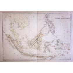
THE INDIAN ARCHIPELAGO (Indonesia & Borneo)
Original steel engraved map drawn & engraved by Edward Weller, published by Blackie & Son, in Edinburgh 1864.
Date: Edinburgh, 1864
Selling price: ????
Please login to see price!
Sold in 2015

A set of 15 prints from Punch or The London Charivari 1860 - 1864 relating to Giuseppe Garibaldi & Italy.
Garibaldi was a central figure in the Italian Resurgence to form The Kingdom of Italy. Garibaldi was known as the "Hero of Two Worlds" because of his military e...
Date: London 1860 - 1864
Selling price: ????
Please login to see price!
Sold in 2020
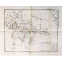
Océanie.
An uncommon map of Australia, New Zealand, and the South Pacific, it extends from Indo-China until California including Hawaii.Names hundreds of small islands and places ...
Date: Paris, 1864
Selling price: ????
Please login to see price!
Sold in 2017
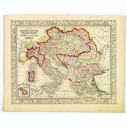
Map of the Austrian Empire, Italian States, Turkey in Europe, and Greece.
A nice example of S. A. Mitchell Jr.'s 1864 map of the Austrian Empire, Italy, Turkey in Europe and Greece. There is an inset in the lower-left corner that features the M...
Date: Philadelphia, 1864
Selling price: ????
Please login to see price!
Sold in 2021

Topographische en militaire kaart van het Koningrijk der Nederlanden / vervaardigd door de officieren van den Generale Staf.
Atlas contains maps of the Kingdom of the Netherlands, executed in lithography, for which the site surveys took place in the years 1852-1854. The maps were made by the of...
Date: 's-Gravenhage, 1864
Selling price: ????
Please login to see price!
Sold
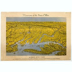
Panorama of the Seat of War. Bird's Eye View of Virginia, Maryland, Delaware and the District of Columbia.
A large chromolithograph by John Bachmann illustrating this fascinating 'aerial' view of the northernmost part of the east coast of the Confederacy, and the southernmost ...
Date: New York, 1864
Selling price: ????
Please login to see price!
Sold in 2020
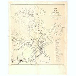
Plan de Saïgon et de ses environs, Levé par M. Foester, Capitaine d'état major.
Map of Saigon and the surrounding area, Surveyed by Mr. Foester, Captain, published by Imprimerie du Gouvernement. Saïgon 1864.Provenance : Pierre-Paul de La Grandière ...
Date: Saigon, 1864
Selling price: ????
Please login to see price!
Sold in 2020
![Illustriss.mo et excell.mo domino domino [...] Viennam Austriae ...](/uploads/cache/46474-250x250.jpg)
Illustriss.mo et excell.mo domino domino [...] Viennam Austriae ...
Rare separately issued circular bird's eye view of Vienna, published by Heinrich Schmidt and Albert Camesina in in Vienna. Showing a rounded view of the area outside of V...
Date: Vienna, 1864
Selling price: ????
Please login to see price!
Sold in 2021
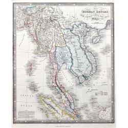
Map of the Burman Empire including also Siam, Cochin-China, Ton-King, and Malaya.
A fine map of the area, including today's Thailand, Vietnam, Sincapore (Singapore), and a part of Borneo. Notes of size and population of Birman Empire, Anam, Siam, Malay...
Date: London, 1864
Selling price: ????
Please login to see price!
Sold in 2021
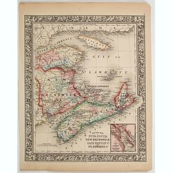
County Map of Nova Scotia, New Brunswick, Cape Breton Island & Prince Edward's Island.
An attractive map of the Canadian Maritime Provinces, with a small inset map of the city and harbor of Halifax. The map pays attention to both political and geographical ...
Date: Pennsylvania, 1864
Selling price: ????
Please login to see price!
Sold in 2023
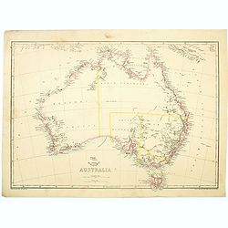
Australia.
Map of Australia by Edward Weller. With a reasonable amount of coastal detail, however, the interior is unsurprisingly bare of any information. No Queensland. 'Northern A...
Date: London, Day and Son, 1865
Selling price: ????
Please login to see price!
Sold in 2023
Atlas usuel de Géographie Moderne…
Complete with title page, contents page, and all 32 double-page maps of European and regional maps of the world, including Oceania, the Americas, Asia, Africa, etc. All i...
Date: Paris, c. 1865
Selling price: ????
Please login to see price!
Sold in 2024
Defenses of Washington
An impressive, beautifully detailed Civil War period plan of Washington D.C. showing the city's defenses. The plan is based on surveys completed in mid-1861 by the United...
Date: New York, 1865
Selling price: ????
Please login to see price!
Sold