Browse Listings
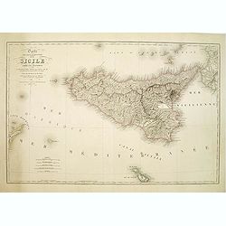
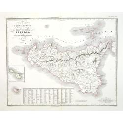
Carte Physique et Routiere de la Sicile..
A very nice exemplary centred on Sicily. Printed by L.Turgis active in Paris and New York. Malta is represented on the bottom.
Date: Paris, 1860
Selling price: ????
Please login to see price!
Sold
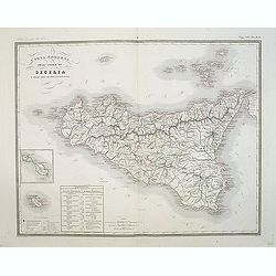
Carta moderna dell' Isola di Sicilia e delle isole minori circonvicine . . .
Map of Sicily from "Atlante Geografico dell Italia". In lower left corner inset maps of Malta.
Date: Rome, 1860
Selling price: ????
Please login to see price!
Sold in 2018
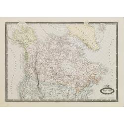
Amérique Boréale, Nouv.le Bretagne & Canada.
Very detailed map from Atlas Sphérodïdal & Universel de géographie , Prepared by F.A.Garnier and edited by Jules Renouard, rue de Tournon, Paris.Uncommon map with ...
Date: Paris 1860
Selling price: ????
Please login to see price!
Sold
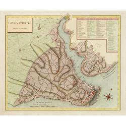
Constantinople superficie 3,975,000 Toises.
Decorative and very detailed plan of Istanbul and its environs. With a numbered key (1-86) to principal places of interest.
Date: Paris 1860
Selling price: ????
Please login to see price!
Sold
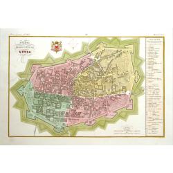
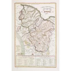
Pianta della citta di Lucca.
Very finely engraved and detailed plan of Lucca. Coat of arms of the town on the upper part. Engraved by V.Angeli and included in: Atlante Geografico dell Italia .To the ...
Date: Rome, 1860
Selling price: ????
Please login to see price!
Sold in 2025
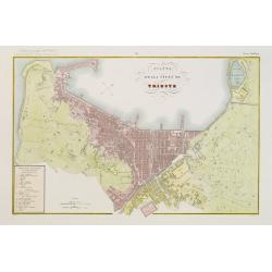
Pianta della citta di Trieste.
Very finely engraved and detailed plan of Triest. Engraved by V.Angeli and included in: Atlante Geografico dell Italia . To the left, a key to the principal buildings and...
Date: Rome, 1860
Selling price: ????
Please login to see price!
Sold in 2020
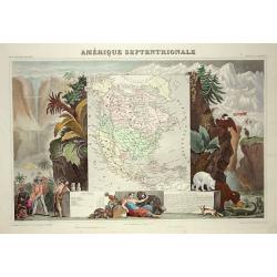
Amerique Septentrionale
Lovely map with an INDEPENDENT TEXAS. The United States extending into present day Canada, Russia in control of Alaska and Mexico's northern border according to the Treat...
Date: Paris 1860
Selling price: ????
Please login to see price!
Sold

Miniature of St Barbara, on vellum from a neo-Gothic Book of Hours.
RECTO : Large miniature of St Barbara, a roman martyr, with her emblem, on the verso of a 15th century leaf from a Book of Hours, Northern Netherlands, 19th cent. Close f...
Date: Flanders ca.1860
Selling price: ????
Please login to see price!
Sold

Miniature showing St. Catherine of Alexandria. Manuscript leaf on vellum from a Neo-Gothic Book of Hours.
RECTO : Miniature showing St. Catherine of Alexandria, who defied the emperor and his wisemen in philosophy, he sentenced her to death through breaking her bones with a h...
Date: Flanders ca.1860
Selling price: ????
Please login to see price!
Sold

Miniature of St. John, the Baptist. Manuscript leaf on vellum from a Neo-Gothic Book of Hours.
RECTO : Miniature of St. John, the Baptist, with a lamb on a book, wearing a cloth of camelhair of the heremite in the desert, not so here though with a luscious backgrou...
Date: Flanders ca.1860
Selling price: ????
Please login to see price!
Sold

Large miniature of Mother Maria and Christ from a Dutch Book of Hours.
RECTO : Large miniature of Mother Maria and Christ, with a book on the bench, Mary is sitting on, teaching her child to read, most certainly a holy book.(90x63mm.) in an ...
Date: Flanders ca.1860
Selling price: ????
Please login to see price!
Sold

Isba, Maison des colonies de l'Amérique Russe.
Early print of a colonial house in Alaska. Engraved by Ch.Ransonette and published by Arthus Bertrand. From: Voyage de M.D. de Mofras .Duflot de Mofras, an attaché of th...
Date: Paris, 1860
Selling price: ????
Please login to see price!
Sold in 2012
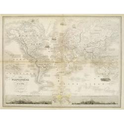
Nouveau Planisphère indiquant las grandes divisions physiques et politiques de la Terre..
Beautifully engraved, map of the world in Mercator's Projection. Two large insets show the relative height of mountains in both hemispheres. A third inset shows the locat...
Date: Paris, 1860
Selling price: ????
Please login to see price!
Sold

Miniature of Crusifiction.
Large miniature of crusification, with in top title Deus in adiutorium meum in tente. Most likely made by the English miniaturist C.W.Wing, who also created around 1850 c...
Date: England c.1860
Selling price: ????
Please login to see price!
Sold
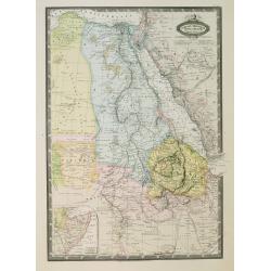
Afrique Orientale, L'Egypte, L'Abyssinie..Takbour Oriental.
Very detailed map from Atlas Spherodidal & Universel de geographie , Prepared by F.A.Garnier and edited by Jules Renouard, rue de Tournon, Paris. Uncommon map with de...
Date: Paris, 1860
Selling price: ????
Please login to see price!
Sold in 2008
Carta antica dell' Isola di Sicilia e delle isole minori circonvicine . . .
Map of ancient Sicily from "Atlante Geografico dell Italia". In lower left corner inset maps of Malta.
Date: Rome, 1860
Selling price: ????
Please login to see price!
Sold in 2018
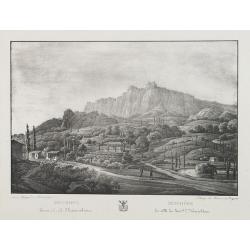
Mischore la ville du General L. Narischkine.
Lithography of the Mischore countryside. Lithographed by Braun and Bigatti.Text in Russian and French.
Date: c. 1860
Selling price: ????
Please login to see price!
Sold in 2014
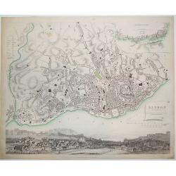
Lisbon (Lisboa)
Nicely engraved plan of Lisbon as known in the mid-19th century. The central portion of the city is outlined in red. In the upper right-hand corner is a map of Lisbon tog...
Date: London, ca. 1860
Selling price: ????
Please login to see price!
Sold in 2011
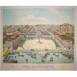
Praca do Commercio.
An exceptionally rare mid 19th century view of central Lisbon. Many of the city's famous historical sites and points of interest are depicted, including Castelo Sao Jorge...
Date: Lisbon, ca. 1860
Selling price: ????
Please login to see price!
Sold in 2011
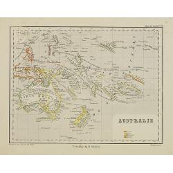
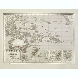
Australie.
Uncommon map of Australia, New Zealand and Pacific. Lithography by J.H. van Weijer, published in Atlas der geheele Aarde in 24 kaarten. With colored key to French, Englis...
Date: Groningen, ca. 1860
Selling price: ????
Please login to see price!
Sold in 2011
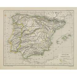
Spanje en Portugal.
Uncommon map of Spain and Portugal. Lithography by J.H. van Weijer, published in Atlas der geheele Aarde [?] in 24 kaarten.
Date: Groningen, ca. 1860
Selling price: ????
Please login to see price!
Sold in 2008
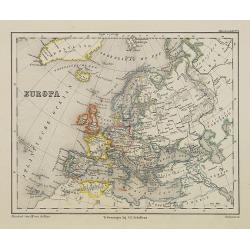
Europa.
Uncommon map of Spain and Portugal. Lithography by J.H. van Weijer, published in Atlas der geheele Aarde [?] in 24 kaarten.
Date: Groningen, ca. 1860
Selling price: ????
Please login to see price!
Sold in 2008
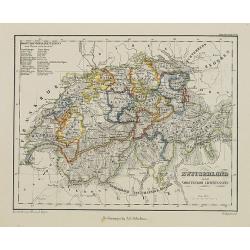
Zwitseland en het Vorstendom Lichtenstein.
Uncommon map of Switzerland and Lichtenstein. Lithography by J.H. van Weijer, published in Atlas der geheele Aarde [?] in 24 kaarten.
Date: Groningen, ca. 1860
Selling price: ????
Please login to see price!
Sold in 2008
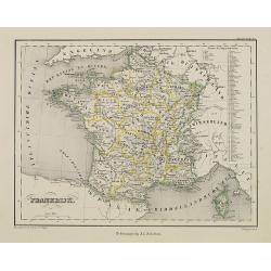
Frankrijk.
Uncommon map of France. Lithography by J.H. van Weijer, published in Atlas der geheele Aarde [?] in 24 kaarten.
Date: Groningen, ca. 1860
Selling price: ????
Please login to see price!
Sold in 2008
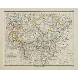
Zuid Duitschland.
Uncommon map of Southern part of Germany. Lithography by J.H. van Weijer, published in Atlas der geheele Aarde [?] in 24 kaarten. Showing railway system.
Date: Groningen, ca. 1860
Selling price: ????
Please login to see price!
Sold in 2008
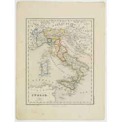
Italie.
Uncommon map of Italy. Lithography by J.H. van Weijer, published in Atlas der geheele Aarde [?] in 24 kaarten.
Date: Groningen, ca. 1860
Selling price: ????
Please login to see price!
Sold in 2019
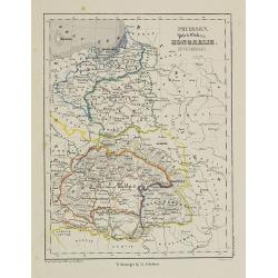
Pruissen, Polen, Galicie, Hongarie, Zevenbergen.
Uncommon map of Prussia, Poland, and Hungary. Lithography by J.H. van Weijer, published in Atlas der geheele Aarde [?] in 24 kaarten.
Date: Groningen, ca. 1860
Selling price: ????
Please login to see price!
Sold in 2008
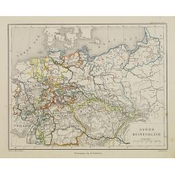
Noord Duitschland.
Uncommon map of the northern part of Germany. Lithography by J.H. van Weijer, published in Atlas der geheele Aarde [?] in 24 kaarten.
Date: Groningen, ca. 1860
Selling price: ????
Please login to see price!
Sold in 2008
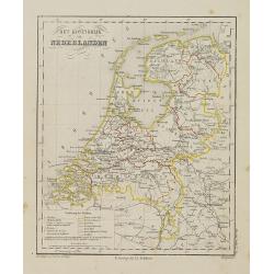
Het Koningrijk de Netherlanden.
Uncommon map of the Netherlands. Lithography by J.H. van Weijer, published in Atlas der geheele Aarde [?] in 24 kaarten.
Date: Groningen, ca. 1860
Selling price: ????
Please login to see price!
Sold in 2008
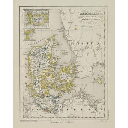
Denemarken Ijsland en de Faroër Eilanden.
Uncommon map of Denmark with inset map of Iceland. Lithography by J.H. van Weijer, published in Atlas der geheele Aarde [?] in 24 kaarten. With colored key to processions...
Date: Groningen, ca. 1860
Selling price: ????
Please login to see price!
Sold in 2008
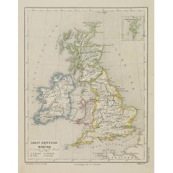
Groot-Brittanje en Ierland.
Uncommon map of England, Ireland and Wales, Scotland. Inset of Shetland islands. Lithography by J.H. van Weijer, published in Atlas der geheele Aarde [?] in 24 kaarten.
Date: Groningen, ca. 1860
Selling price: ????
Please login to see price!
Sold in 2008
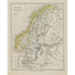
Zweden en Noorwegen.
Uncommon map of Norway and Sweden. Lithography by J.H. van Weijer, published in Atlas der geheele Aarde [?] in 24 kaarten.
Date: Groningen, ca. 1860
Selling price: ????
Please login to see price!
Sold in 2008
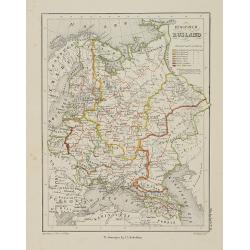
Europish Rusland.
Uncommon map of Russia. Lithography by J.H. van Weijer, published in Atlas der geheele Aarde [?] in 24 kaarten. With colored key to processions.
Date: Groningen, ca. 1860
Selling price: ????
Please login to see price!
Sold in 2008
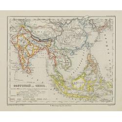
Oostindië en China.
Uncommon map of India, South East Asia, Taiwan, Japan and China. Lithography by J.H. van Weijer, published in Atlas der geheele Aarde [?] in 24 kaarten. With colored key...
Date: Groningen, ca. 1860
Selling price: ????
Please login to see price!
Sold in 2008
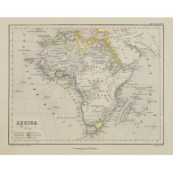
Afrika.
Uncommon map of Africa. Lithography by J.H. van Weijer, published in Atlas der geheele Aarde [?] in 24 kaarten. With colored key to English, French, Dutch, Spanish, Port...
Date: Groningen, ca. 1860
Selling price: ????
Please login to see price!
Sold in 2008
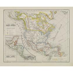
Noord-Amerika.
Uncommon map of North America including Canada and Mexico. Inset map of Central America. Lithography by J.H. van Weijer, published in Atlas der geheele Aarde [?] in 24 ka...
Date: Groningen, ca. 1860
Selling price: ????
Please login to see price!
Sold in 2008
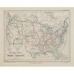
Vereenigde Staten van Noord-Amerika.
Uncommon map of the United States of America. Lithography by J.H. van Weijer, published in Atlas der geheele Aarde [?] in 24 kaarten.
Date: Groningen, ca. 1860
Selling price: ????
Please login to see price!
Sold in 2015
![Oostelijk Halfrond. [Eastern hemisphere]](/uploads/cache/25546-250x250.jpg)
Oostelijk Halfrond. [Eastern hemisphere]
Uncommon world map of the eastern hemisphere. Lithography by J.H. van Weijer, published in Atlas der geheele Aarde [?] in 24 kaarten. Showing a completed coastline for A...
Date: Groningen, ca. 1860
Selling price: ????
Please login to see price!
Sold in 2010
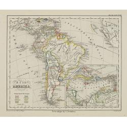
Zuid Amerika.
Uncommon map of South America. Lithography by J.H. van Weijer, published in Atlas der geheele Aarde [?] in 24 kaarten. With colored key to English, French, Dutch, Spanish...
Date: Groningen, ca. 1860
Selling price: ????
Please login to see price!
Sold in 2012
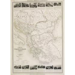
Nouvelle carte Illustrée Turquie d'Europe et de la Grèce . . .
A most decorative mid 19th century map, in upper and lower part 12 vignettes giving a wealth of statistic and commercial information. With a color key . Beside Greeve the...
Date: Paris, Fatout, 1860
Selling price: ????
Please login to see price!
Sold in 2010
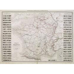
Nouvelle carte Illustrée de la France . . .
A most decorative mid 19th century "carte à figures" map, in left and right part 86 vignettes giving a wealth of statistic and commercial information of each r...
Date: Paris, Fatout, 1860
Selling price: ????
Please login to see price!
Sold
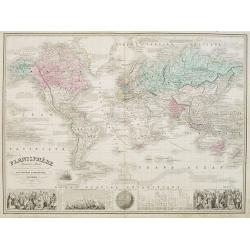
Planisphère elémentaire et Illustré. . .
A most decorative mid 19th century world map on Mercator's projection. A panel at bottom features vignette engravings of the races of man, heights of mountains and length...
Date: Paris, Fatout, 1860
Selling price: ????
Please login to see price!
Sold in 2011
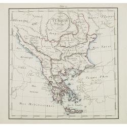
Turquie d'Europe.
Map of Greece, including Serbia, Bulgaria, Albania, Bosnia.
Date: France, ca. 1860
Selling price: ????
Please login to see price!
Sold in 2015
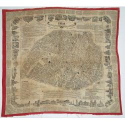
Paris - Foulard Renault, Guide dans Paris / Renault\'s illustrated Paris Guide.
Plan of Paris printed on textile. Surrounded with text and numerous vignettes.
Date: Rouen, ca. 1860
Selling price: ????
Please login to see price!
Sold in 2008
Algérie d'après les cartes de L'état-major et les documents du Ministère de la Guerre
A map of Algeria.
Date: Paris, 1860
Selling price: ????
Please login to see price!
Sold in 2008
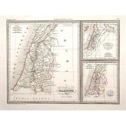
Palestine./ Royaume des Israelites sous David et Salomon..
Three maps on one sheet of Holy Land during Roman times, during David and Salomon and one divided into 12 tribes.Engraved by Thierry, rue des Mathurins St.Jacques No.1, P...
Date: Paris, 1860
Selling price: ????
Please login to see price!
Sold in 2009
Nouvelle carte illustrée des Etats du Nord et de l'Europe donnant la Russie d'Europe La Suède et le Danemark . . .
A most decorative mid 19th century map, in left and right part 20 vignettes giving a wealth of statistic and commercial information. Besides Russia's provinces the neighb...
Date: Paris, ca. 1860
Selling price: ????
Please login to see price!
Sold in 2009
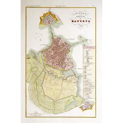
Pianta della citta di Mantova.
Very finely engraved and detailed plan of Mantova. Engraved by V.Angeli and included in: Atlante Geografico dell Italia . To the right side, a key to the principal buildi...
Date: Rome, 1860
Selling price: ????
Please login to see price!
Sold in 2009

Moscou. (Russie).
View of Moscow. Drawn and engraved by Lechard.
Date: Paris, Mutrel, ca. 1860
Selling price: ????
Please login to see price!
Sold in 2009
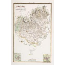
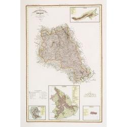
Governo di Venezia / Provincia di Verona / Vicenza.
Very finely engraved and detailed map centered on Verona, including, Vicenzia and Lago di Garda to the left.. Lower corners two inset plans of Verona and Vicenza. Key cen...
Date: Rome, 1860
Selling price: ????
Please login to see price!
Sold in 2020
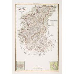
Ducato di Lucca.
Very finely engraved and detailed map centered on Lucca, covering the region east of Massa and Pizza. Lower part of the map, two inset lists of the territorial divisions ...
Date: Rome, 1860
Selling price: ????
Please login to see price!
Sold in 2018
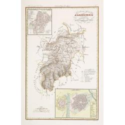
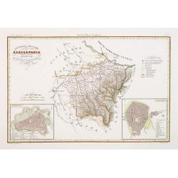
Divisione Militare di Alessandria.
Very finely engraved and detailed map centered on Alessandria and Acqui. Upper corners, two inset plans of Alessandria and Acqui. Key on the right side. Engraved by Vetto...
Date: Rome, 1860
Selling price: ????
Please login to see price!
Sold in 2016
Governo di Venezia. Provincie di Belluno e Treviso.
Very finely engraved and detailed map covering the region of Treviso and Belluno. Lower left corners, two inset plans of Treviso and Belluno. Key on the upper right side....
Date: Rome, 1860
Selling price: ????
Please login to see price!
Sold in 2018
Divisione Militare di Alessandria.Tortona / Voghera.
Very finely engraved and detailed map of the province of Alessandria. Lower corners, two inset plans of Tortona and Voghera. Key on the right side. Engraved by Vettorio A...
Date: Rome, 1860
Selling price: ????
Please login to see price!
Sold in 2017
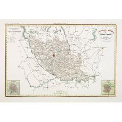
Governo di Milano / Provincia di Pavia e Lodi.
Very finely engraved and detailed map of the area of Milan, Lodi, Crema and Pavia. Lower corners, two inset plans of Pavia and Lodi. Upper left corner, a key. Engraved by...
Date: Rome, 1860
Selling price: ????
Please login to see price!
Sold in 2017
Compartimento Senese.
Very finely engraved and detailed map centered on Sienna. Upper right corner, an inset plan of Colle, and lower part corner, three inset plans of Montalcino, Siena and Pi...
Date: Rome, 1860
Selling price: ????
Please login to see price!
Sold in 2014
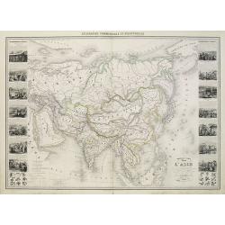
Nouvelle Carte Illustrée de l'Asie . . .
Attractive large chart of Asia from a rare nineteenth century atlas. Decorated with an impressive array of information illustrating the physical and geographical division...
Date: Paris, 1860
Selling price: ????
Please login to see price!
Sold in 2010
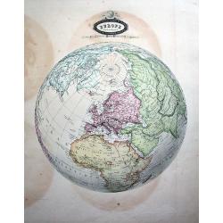
Europe Sphéroïdale.
Uncommon map of the sphere, centered on Europe. Extending until South America, Madagascar, South-East Asia, and Alaska (Russian America!) A rare and decorative map!
Date: Paris, 1860
Selling price: ????
Please login to see price!
Sold in 2010
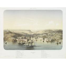
MER NOIRE Sébastopol. 61.
Beautiful and rare lithography of the port of Sevastopol at the Black Sea the Crimea peninsula. Extensive shipping in the harbor. With a numbered key (1-22) in lower part...
Date: Paris, Lemercier, c.1860
Selling price: ????
Please login to see price!
Sold in 2010

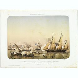
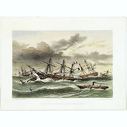
MER D'AZOF. Bombardement d'arabat par la flotille alliée 25 Mai 1855.
Beautiful and rare lithography of two French boats, "Le Lucifer" and "La Miranda" during the siege of Arabat in 1855.
Date: Paris, Lemercier, c.1860
Selling price: ????
Please login to see price!
Sold in 2010
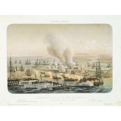
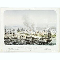
AFFAIRES D'ORIENT Attaque et reddition du fort de Kilburn par les flottes alliées, 17 octobre 1855.
Beautiful engraving of the siege of Kilburn on 17 October 1855 by the French navy. After a design Louis by Le Breton. including a numbered key (1-4) in the lower part.Lou...
Date: Paris, Lemercier, c.1860
Selling price: ????
Please login to see price!
Sold in 2010
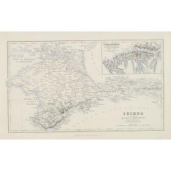
Crimea according to Huot & Demidoff.
Detailed map probably from, A Gazetteer of the World, Or Dictionary of Geographical Knowledge, Compiled from the Most Recent Authorities, and Forming a Complete Body of M...
Date: Edinburg, London, Fullarton, 1860
Selling price: ????
Please login to see price!
Sold in 2010
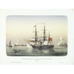
Division anglaise détruisant les forts des Russes à l'entrée du Golfe de Finlande.
Showing two English ships attaching a Russian stronghold in the Gulf of Finland during June 1854. The Crimean War (1854-1856) between Russia on one side and the alliance ...
Date: Paris, 1860
Selling price: ????
Please login to see price!
Sold in 2014
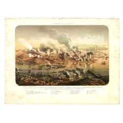
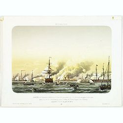
Sébastopol vue du Nord. - Les divisions françaises aux ordres des généraux Bosquet et Mac Mahon prennent d'assaut la tour Malakoff. . , (le 8 septembre 1855). Crimée (Ukraine)
Lithography of the siege of Sebastopol on 8 September 1855 who resulted in a French victory under General MacMahon. In one of the Crimean War defining moments, the French...
Date: Paris, Lemercier, c.1860
Selling price: ????
Please login to see price!
Sold in 2010
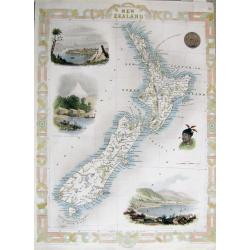
NEW ZEALAND
Very attractive steel engraved map of New Zealand. A later edition after Tallis. Surrounded by illustrations of Auckland, Mount Egmont from New Plymouth, a Maori's tatto...
Date: London, London Printing and Publishing Company, c.1860
Selling price: ????
Please login to see price!
Sold in 2011
AFFAIRES D'ORIENT Attaque et reddition du fort de Kilburn par les flottes alliées, 17 octobre 1855.
Beautiful lithography of the siege of Kilburn on 17 October 1855 by the French navy. After a design Louis by Le Breton. including a numbered key (1-4) in lower part.Louis...
Date: Paris, Lemercier, c.1860
Selling price: ????
Please login to see price!
Sold in 2014
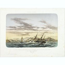
AFFAIRES D'ORIENT Le Vauban, Commandé par le Captaine de Vaisseau d'Herbinghem, chasse devant lui deux Croiseurs Russes qui se réfugient à Sévastopol. Mars 1854.
Beautiful lithography of the French steamer "Le Vaunan", commanded by Captain de Poucques d'Herbingheme, chasing two Russian Vessels seeking safe-harbour in Sev...
Date: Paris, Lemercier, c.1860
Selling price: ????
Please login to see price!
Sold in 2013
EXPEDITION DE LA MER D'AZOF Le Lieutenant M.Killop Captain la canonniére le Snake, sous le feu des batteries de Kertch. . . 22 Mai 1855.
Beautiful lithography of an encounter which took place on 22 May 1855 between Lieutenant M'Killop, who was the commander of a gunboat, the Snake, with 3 Russian vessels, ...
Date: Paris, Lemercier, c.1860
Selling price: ????
Please login to see price!
Sold in 2014
MER BALTIQUE Juillet 1855 Les Vasseaux le Blenheim et l'Exmouth aux ordres du C.A. Seymour protegent de leur feux une division de cannonieres qui sous la volées des Forts Russes vont amarriner des prises q l'entree du port de Narva.
Beautiful lithography of the vessels Blenheim and l'Exmouth bombarding the forts at the entrance of the river and town of Narva in July 1855.After a design Louis by Le Br...
Date: Paris, Lemercier, c.1860
Selling price: ????
Please login to see price!
Sold in 2014
Ouragan du 14 dans la Mere Noir vis à vis la Baie de Kamiesh.
Beautiful lithography of French ships in Kamiesch Bay in the Black Sea near Sebastopol on the Crimean coast. During the siege of Sebastopol in 1854 during the Crimean War...
Date: Paris, Lemercier, c.1860
Selling price: ????
Please login to see price!
Sold in 2014

Le descartes devant Sébastopol.
Beautiful lithography of the French steamer Le Descartes offshore of Sevastopol.After a design by Louis Le Breton (1818 Douarnenez - 1866 Paris). Louis Le Breton was a Fr...
Date: Paris, Langlumé, c.1860
Selling price: ????
Please login to see price!
Sold in 2014
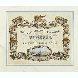
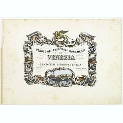
Vedute dei principali monumenti di Venezia.
Decorative title page with in the lower part small inset view of Doge Palace, St. Marco and a gondola.
Date: Venice, Eugenio Testolini, ca 1860
Selling price: ????
Please login to see price!
Sold in 2011
Australie naar de beste Bronnen. . .
Detailed map of Australia with insets of West Australia, New South Wales, van Diemensland. Showing the Pacific with part of China, Borneo, and New Guinee.The firm Oomkens...
Date: Groningen, 1860
Selling price: ????
Please login to see price!
Sold in 2011
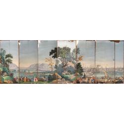
2 Papier peints: 'West Point in New York'' and ''Boston Harbor''.
Two panels from one of Zuber's grandest panoramic wallpapers (papier peint) is a set of American landscapes, "Les Vues de L'Amérique du Nord" (Views of North A...
Date: Rixham, ca. 1852 - 1860
Selling price: ????
Please login to see price!
Sold in 2011
(Title page) Vedute dei principali monumenti di Venezia.
Decorative title page with in the lower part small inset view of Doge Palace, St. Marco and a gondola.
Date: Venice, 1860
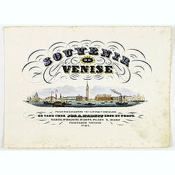
(Title page) Souvenir de Venise.
Title page with a panoramic view of Venice after Canaletto. Lithographed by P.Chevalier. The publication was according to the text for sale at Jos.a Habnit, who was estab...
Date: Venice, c.1860
Selling price: ????
Please login to see price!
Sold in 2011

(Title page) Vedute di Venezia.
Title page with a virgin and the lion of saint Mark sitting on an island with in the background the town of Venice. Lithography by Lefevre after G.B. Cecchini.
Date: Venice, ca 1860
Selling price: ????
Please login to see price!
Sold in 2022
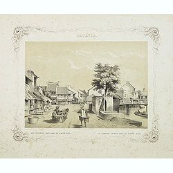
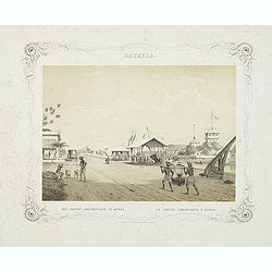
BATAVIA. Het chinesche kamp nabij de pintoe kitjil. Le campong chinois, près de Pintoe Kitjil.
Rare lithographed view of the Chinese camp nearby Pintoe Kitjil in Batavia (Jakarta). Beautiful lithography drawn by Charles Theodore Deeleman (1823 - 1884), lithographed...
Date: Batavia, 1859-1860
Selling price: ????
Please login to see price!
Sold in 2011
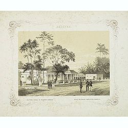
BATAVIA. Militaire school te Meester-Cornelis. Ecole militaire à Meester-Cornelis.
Rare lithographed view of the military school at Meester Cornelis in Batavia (Jakarta). Beautiful lithography drawn by Charles Theodore Deeleman (1823 - 1884), lithograph...
Date: Batavia, 1859-1860
Selling price: ????
Please login to see price!
Sold in 2011
BATAVIA. Het jaagpad, landingsplaats te Batavia. Le jagpad, embarcadere à Batavia.
Rare lithographed view of the harbour of Batavia (Jakarta). Beautiful lithography drawn by Charles Theodore Deeleman (1823 - 1884), lithographed by G.J. Bos and printed b...
Date: Batavia, 1859-1860
Selling price: ????
Please login to see price!
Sold in 2011