Browse Listings
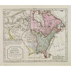
Canada, Louisiane, États-Unis.
Although dated 1794/95 [l'An 3e.], the map is a copy of an earlier map which appeared in Robert de Vaugondy''s 1778 atlas. Two maps on one sheet. The map of the western p...
Date: Paris, 1794 - 1806
Selling price: ????
Please login to see price!
Sold in 2016
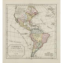
L'Amérique.
Although dated 1794/95 [l'An 3e.], the map is a copy of an earlier map which appeared in Robert de Vaugondy's 1778 atlas. Map of North and South America. By C. F. Delamar...
Date: Paris, 1794 - 1806
Selling price: ????
Please login to see price!
Sold
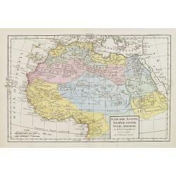
Barbarie, Egypte, Nigrite, Guinée, Nubie, Abissinie.
Map of Morocco, Tunisia, Libya, Egypt, Guinea, Nubia and Abyssinia. By C. F. Delamarche, successor of Robert de Vaugondy, Geographer.
Date: Paris, 1794 - 1806
Selling price: ????
Please login to see price!
Sold in 2009
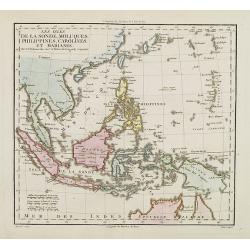
Les Isles de la Sonde, Moluques, Philippines, Carolines et Marianes.
Map of South East Asia. By C. F. Delamarche, successor of Robert de Vaugondy, Geographer.
Date: Paris, 1794 - 1806
Selling price: ????
Please login to see price!
Sold in 2014
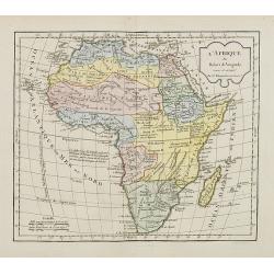
L'Afrique.
Map of Africa. By C. F. Delamarche, successor of Robert de Vaugondy, Geographer.
Date: Paris, 1794 - 1806
Selling price: ????
Please login to see price!
Sold in 2008
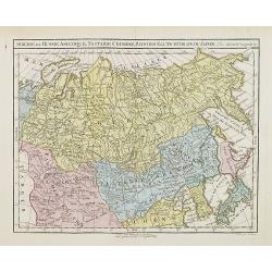
Siberie ou Russie Asiatique, Tartarie Chinoise, Pays des Eluts et Isles du Japon.
Map of the Kamchatka peninsula, Russian Far East., Korea, Japan, with Hokaido labeled "Terre del Jeso".By C. F. Delamarche, successor of Robert de Vaugo...
Date: Paris, 1794 - 1806
Selling price: ????
Please login to see price!
Sold in 2009
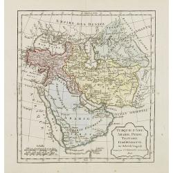
Turquie d'Asie, Arabie, Perse, Tartarie Indépendante.
Map of the Turkey and the Arabian peninsula. By C. F. Delamarche, successor of Robert de Vaugondy, Geographer.
Date: Paris, 1794 - 1806
Selling price: ????
Please login to see price!
Sold in 2009
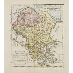
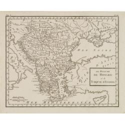
Hongrie, Turquie Europe..
Map of Hungary, southeast European countries in the Balkan peninsula, and Greece. By C. F. Delamarche, the successor of Robert de Vaugondy, Geographer.
Date: Paris, 1794 - 1806
Selling price: ????
Please login to see price!
Sold in 2008

Partie de l'empire français Royaume d'Italie, Toscane Etat du St. Siege Isle de Corse. . .
Map of Northern part of Italy with Corsica. By C. F. Delamarche, successor of Robert de Vaugondy, Geographer. With a color key showing the Italian and French possessions....
Date: Paris, 1806
Selling price: ????
Please login to see price!
Sold in 2008
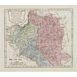
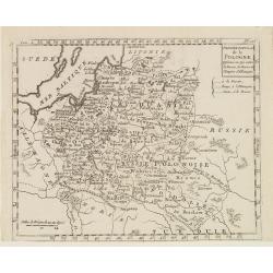
Royaume de Pologne.
Map of Poland and Lithuania. By C. F. Delamarche, successor of Robert de Vaugondy, Geographer.With a color key to Russian, Prussian and Austrian possessions.
Date: Paris, 1794 - 1806
Selling price: ????
Please login to see price!
Sold in 2008
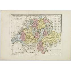
La République Helvétique en ses 19 Cantons.
Map of Switzerland. By C. F. Delamarche, successor of Robert de Vaugondy, Geographer.
Date: Paris, 1794 - 1806
Selling price: ????
Please login to see price!
Sold in 2019
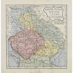
Bohême, Silésie, Moravie, Lusace.
Map of central Europe including Bohemia, Austria, Hungary, Silesia and Moravia. By C. F. Delamarche, successor of Robert de Vaugondy, Geographer.
Date: Paris, 1794 - 1806
Selling price: ????
Please login to see price!
Sold in 2015
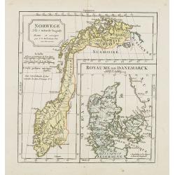
Norwege. . .
Map of Norway., with inset map of Denmark.By C. F. Delamarche, successor of Robert de Vaugondy, Geographer.
Date: Paris, 1794 - 1806
Selling price: ????
Please login to see price!
Sold in 2023
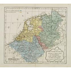
Partie de l'Empire Français, Royaume de Hollande, de Westphalie, Grand Duché de Berg.
Map of the Netherlands. By C. F. Delamarche, successor of Robert de Vaugondy, Geographer. With a color key to French and Dutch possessions.
Date: Paris, ca.1806
Selling price: ????
Please login to see price!
Sold in 2008
![[Butterflies]](/uploads/cache/25583-250x250.jpg)
[Butterflies]
Plate CLIX from Carl Gustav Jablonsky and J.F.W. Herbst: "Natursystem aller bekannten in- und ausländischen Insecten", engraved by Bodenehr. Carl Gustav Jablon...
Date: Berlin, J. Pauli, 1785-1806
Selling price: ????
Please login to see price!
Sold in 2023
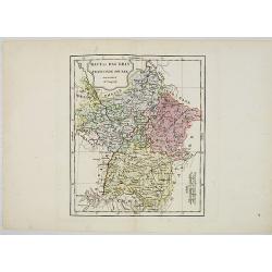
Haut et Bas Rhin Franconie Souabe.
Map of High and Low Rhine Franconie Souabe. By Robert de Vaugondy, Geographer.
Date: Paris, 1794 - 1806
Selling price: ????
Please login to see price!
Sold in 2022
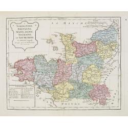
Normandie, Bretagne, Maine, Anjou, Tourraine, et Saumurois.
Map of Normandy, Brittany, Maine, Anjou, Tourraine, and the Saumur region. By C. F. Delamarche, successor of Robert de Vaugondy, Geographer. Inset lower left corner of t...
Date: Paris, 1794 - 1806
Selling price: ????
Please login to see price!
Sold in 2008
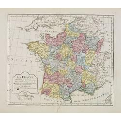
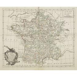
La France. . . .
Map of France. By C. F. Delamarche, successor of Robert de Vaugondy, Geographer.
Date: Paris, 1806
Selling price: ????
Please login to see price!
Sold in 2008
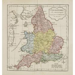
L'Angleterre.
Map of England. By C. F. Delamarche, successor of Robert de Vaugondy, Geographer.
Date: Paris, 1794 - 1806
Selling price: ????
Please login to see price!
Sold in 2011
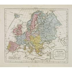
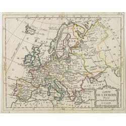
L'Europe. . .
Map of the European continent. By C. F. Delamarche, successor of Robert de Vaugondy, Geographer.
Date: Paris, 1794 - 1806
Selling price: ????
Please login to see price!
Sold in 2008

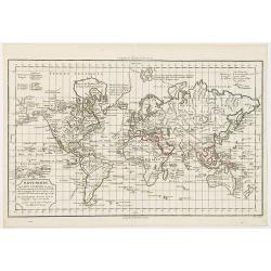
Mappe-Monde ou carte générale de toutes les parties du globe, corrigée et augmentée des découvertes du Cap, Cook, de celles de la Pérouse en 1881. de Vancouver, de Mackensie en 1882, auxquelles sont ajoutées celles faites dans la Mer du Sud. . .
Map of the world in a Mercator projection. By C. F. Delamarche, successor of Robert de Vaugondy, Geographer.
Date: Paris, 1794 - 1806
Selling price: ????
Please login to see price!
Sold in 2013
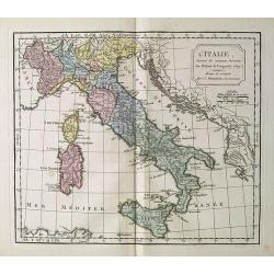
L' Italie.
Map of Italy. By C. F. Delamarche, successor of Robert de Vaugondy, Geographer.
Date: Paris, 1794 - 1806
Selling price: ????
Please login to see price!
Sold in 2018
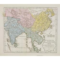
Indostan, presqu'isles de l'Inde, Chine, Tartarie Indépendendante.
Map of Hindustan, the Indian peninsula , China, and Tartary. By C. F. Delamarche, successor of Robert de Vaugondy, Geographer.Uncommon later edition with the date 1806. ...
Date: Paris, 1806
Selling price: ????
Please login to see price!
Sold in 2009
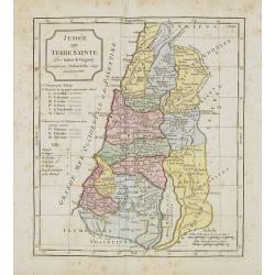
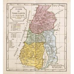
Judée ou Terre Sainte.
Map of the Holy Land, Judea. By C. F. Delamarche, successor of Robert de Vaugondy, Geographer.
Date: Paris, 1794 -1806
Selling price: ????
Please login to see price!
Sold in 2011
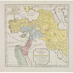
Carte des Premiers Ages du Monde. Géographie Ecclésiastique de la Turquie, d'Asie et de la Perse.
Map of the Arabian peninsula and Turkey. By C. F. Delamarche, successor of Robert de Vaugondy, Geographer.
Date: Paris, 1794 -1806
Selling price: ????
Please login to see price!
Sold in 2023
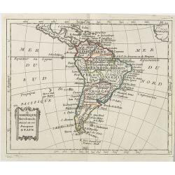
L'Amérique Méridionale . . .
Map of the South American continent, from Atlas moderne portatif composé de vingt-huit cartes sur toutes les parties du globe terrestre .. A l'usage des Colléges, des P...
Date: Paris, Prudhomme, Levrault, Debray, 1806
Selling price: ????
Please login to see price!
Sold in 2019
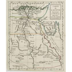
Carte de l'Egypte . . .
Map of Egypt, from Atlas moderne portatif composé de vingt-huit cartes sur toutes les parties du globe terrestre .. A l'usage des Colléges, des Pensions & des Maiso...
Date: Paris, Prudhomme, Levrault, Debray, 1806
Selling price: ????
Please login to see price!
Sold in 2011
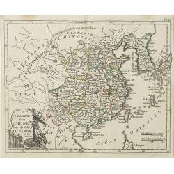
L'Empire de la Chine avec les Isles du Japon et la Corée . . .
Map of the Chinese Empire with Japan, Taiwan (Formose I.) and Korea, from Atlas moderne portatif composé de vingt-huit cartes sur toutes les parties du globe terrestre ....
Date: Paris, Prudhomme, Levrault, Debray, 1806
Selling price: ????
Please login to see price!
Sold
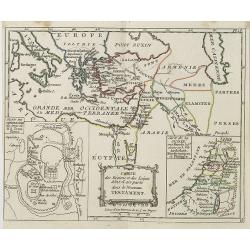
Carte des Régions et Lieux dont il est parlé dans le Nouveau Testament . . .
Map of the regions and sites mentioned in the New Testament with inset maps of the Holy Land and a plan of Jerusalem, from Atlas moderne portatif composé de vingt-huit c...
Date: Paris, Prudhomme, Levrault, Debray, 1806
Selling price: ????
Please login to see price!
Sold in 2019
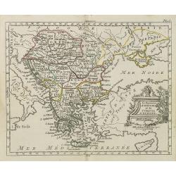
Le Royaume de Hongrie et la Turquie d' Europe . . .
Map of the Hungary, the Balkan States and present-day Greece, from Atlas moderne portatif composé de vingt-huit cartes sur toutes les parties du globe terrestre .. A l'u...
Date: Paris, Prudhomme, Levrault, Debray, 1806
Selling price: ????
Please login to see price!
Sold in 2010
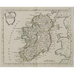
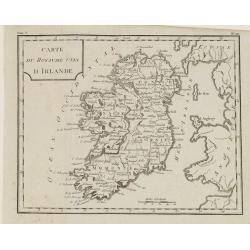
Carte du Royaume d' Irlande . . .
Map of Ireland, from Atlas moderne portatif composé de vingt-huit cartes sur toutes les parties du globe terrestre .. A l'usage des Colléges, des Pensions & des Mai...
Date: Paris, Prudhomme, Levrault, Debray, 1806
Selling price: ????
Please login to see price!
Sold in 2018
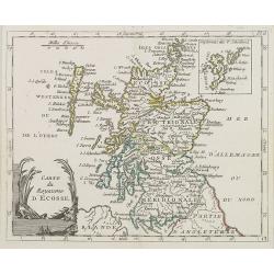
Carte du Royaume d' Ecosse . . .
Map of Scotland from Atlas moderne portatif composé de vingt-huit cartes sur toutes les parties du globe terrestre .. A l'usage des Colléges, des Pensions & des Mai...
Date: Paris, Prudhomme, Levrault, Debray, 1806
Selling price: ????
Please login to see price!
Sold in 2013
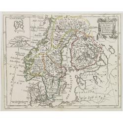
Les Couronnes du Nord, comprenant les royaumes de Suede, Norwege et Danemark.
Map of Sweden, Norway and Denmark, from Atlas moderne portatif composé de vingt-huit cartes sur toutes les parties du globe terrestre .. A l\'usage des Colléges, des Pe...
Date: Paris, Prudhomme, Levrault, Debray, 1806
Selling price: ????
Please login to see price!
Sold in 2009
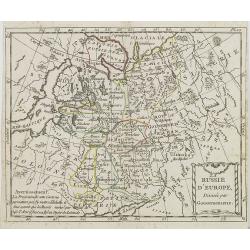
La Russie d\'Europe . . .
Map of western part of Russia, from Atlas moderne portatif composé de vingt-huit cartes sur toutes les parties du globe terrestre .. A l\'usage des Colléges, des Pensio...
Date: Paris, Prudhomme, Levrault, Debray, 1806
Selling price: ????
Please login to see price!
Sold in 2009
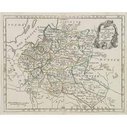
Carte Générale de la Pologne . . .
Map of Poland, from Atlas moderne portatif composé de vingt-huit cartes sur toutes les parties du globe terrestre .. A l'usage des Colléges, des Pensions & des Mais...
Date: Paris, Prudhomme, Levrault, Debray, 1806
Selling price: ????
Please login to see price!
Sold in 2016
Carte de l' Europe . . .
General map of Europe from Atlas moderne portatif composé de vingt-huit cartes sur toutes les parties du globe terrestre .. A l'usage des Colléges, des Pensions & d...
Date: Paris, Prudhomme, Levrault, Debray, 1806
Selling price: ????
Please login to see price!
Sold in 2009
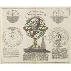
La Sphère Artificielle, ou Armilaire Oblique.
Decorative print showing a celestial hemisphere, surrounded by projections of Brahe, Copernicus and Ptolemy, from Atlas moderne portatif composé de vingt-huit cartes sur...
Date: Paris, Prudhomme, Levrault, Debray, 1806
Selling price: ????
Please login to see price!
Sold in 2018
Carte du Royaume de France . . .
General map of France, from Atlas moderne portatif composé de vingt-huit cartes sur toutes les parties du globe terrestre .. A l'usage des Colléges, des Pensions & ...
Date: Paris, Prudhomme, Levrault, Debray, 1806
Selling price: ????
Please login to see price!
Sold in 2009
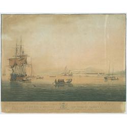
Cape Coast Castle, a British Settlement on the Gold Coast, Africa...
The image views Cape Coast Castle from the sea, it is positioned to the right of centre, a large ship is on the right with several smaller sailing ships, in the foregroun...
Date: G. Webster & J. Barrow, London Oct. 26th 1806
Selling price: ????
Please login to see price!
Sold in 2009
La Pologne Dressée sur ce qu'en ot donné Starovolsk, Beauplan, Hartnoch. . .
This is a late edition of the De L'Isle copper plate with a date of 1806. The copper plate was used many times and has several erased addresses.Large map of Poland, Lithu...
Date: Paris, 1806
Selling price: ????
Please login to see price!
Sold in 2010
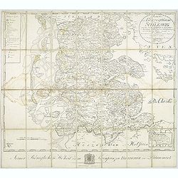
Karte vom Herzogthum Schleswig, nach der von der Gesellschaft der Wissenschaften in Kopenhagen bekannt gewordenen Ortsbestimmung und nach Special-Karten. Kolor. Kupferstichkarte von F. v. Golowin. Schleswig, Röhss u. Christiani, 1806.
Von Golowin was a Lieutenant in the "Schleswigschen Infanterie-Regiment" and appointed cartographer to the King. The first edition of this road map was publishe...
Date: Schleswig, Röhfs und Christiani, 1806
Selling price: ????
Please login to see price!
Sold in 2010
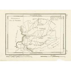
Département des 2 Nethes.
Map representing the area around Antwerp, with a short key list in the upper right corner.From Atlas de la Géographie de toutes les parties du monde .. Ouvrage destiné ...
Date: Paris, Prudhomme, Levrault, Debray, 1806
Selling price: ????
Please login to see price!
Sold in 2017
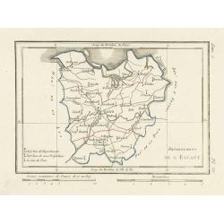
Département de l'Escaut.
Map centered on Gand, with a short key list in the lower left corner. From Atlas de la Géographie de toutes les parties du monde .. Ouvrage destiné pour l'education, et...
Date: Paris, Prudhomme, Levrault, Debray, 1806
Selling price: ????
Please login to see price!
Sold
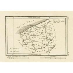
Département de la Lys.
Map representing the area between Furnes, Ypres, Courtray and Bruges, with a short key list in the upper right corner.From Atlas de la Géographie de toutes les parties d...
Date: Paris, Prudhomme, Levrault, Debray, 1806
Selling price: ????
Please login to see price!
Sold in 2023

Homme & Femme Ottawas.
Hand-colored mezzotints of Native Americans engraved by Félix Mixelle and Lachaussée Jeune after Jacques Grasset de Saint-Sauveur.
Date: Paris,1801-1806
Selling price: ????
Please login to see price!
Sold in 2011
Homme & Femme Iroquoia.
Hand-colored mezzotints of Native Americans engraved by Félix Mixelle and Lachaussée Jeune after Jacques Grasset de Saint-Sauveur.
Date: Paris,1801-1806
Selling price: ????
Please login to see price!
Sold in 2011

Homme et Femme de Virginie.
Hand-colored mezzotints of Native Americans engraved by Félix Mixelle and Lachaussée Jeune after Jacques Grasset de Saint-Sauveur.
Date: Paris,1801-1806
Selling price: ????
Please login to see price!
Sold in 2011

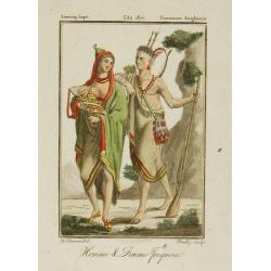
Homme & Femme de Népissens.
Hand-colored mezzotints of Native Americans engraved by Félix Mixelle and Lachaussée Jeune after Jacques Grasset de Saint-Sauveur.
Date: Paris,1801-1806
Selling price: ????
Please login to see price!
Sold in 2011
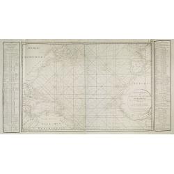
Carte générale de l'Océan Atlantique ou occidental, Dresse au depot general des Cartes Plans et Journaux/de la Marine/en 1786
Seventh edition of this magnificent sea chart of the Atlantic Ocean, covered in rhumb lines. Map flanked with extensive lists of tides, ‘Tables des Latitudes and Longit...
Date: Paris, 1806
Selling price: ????
Please login to see price!
Sold in 2022
![Morokoshi Meisho Zue [Illustrated Description of Famous Sites of China].](/uploads/cache/00003-250x250.jpg)
Morokoshi Meisho Zue [Illustrated Description of Famous Sites of China].
Very rare first edition, of the famous places of Qing dynasty in China, edited and illustrated by the Japanese artists Okada Gyokuzan (1737–1812), Oka Yugaku (1762–18...
Date: Osaka, Kawachiya Kichibei, Bunka, year of the tiger, 1806
Selling price: ????
Please login to see price!
Sold in 2011
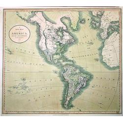
A NEW MAP OF AMERICA
John Cary’s important and very detailed 1806 Map of the Western Hemisphere. Prepared in 1805 by John Cary for issue in his magnificent 1808 New Universal Atlas. Alask...
Date: London, 1806
Selling price: ????
Please login to see price!
Sold in 2011
Mappe-Monde ou carte générale de toutes les parties du globe, corrigée et augmentée des découvertes du Cap, Cook, de celles de la Pérouse en 1881. de Vancouver, de Mackensie en 1882, auxquelles sont ajoutées celles faites dans la Mer du Sud. . .
Map of the world in a Mercator projection. Tasmania joined to Australia's mainland. An oversized Novaya Zemlya (Nova Zembla.) By C. F. Delamarche, the successor of Robert...
Date: Paris, 1794 - 1806
Selling price: ????
Please login to see price!
Sold in 2011
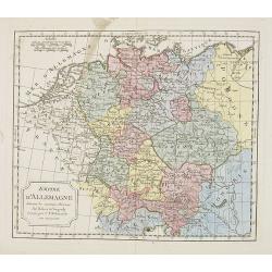
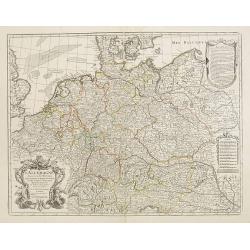
Empire d'Allemagne. . .
Map of the German Empire. By C. F. Delamarche, successor of Robert de Vaugondy, Geographer.
Date: Paris, 1794 – 1806
Selling price: ????
Please login to see price!
Sold in 2022
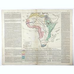
L'Afrique avec ses divisions geographiques, les colonies Europeennes. . .
Interesting map of Africa, bordered with geographical notes. color key to 5 travels by de la Vailland, Park, Browne, Hornmann and Bruce.
Date: Florence, 1806
Selling price: ????
Please login to see price!
Sold in 2020
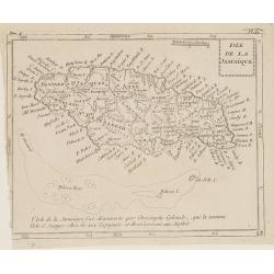
Isle de la Jamaïque.
Map of Jamaica, from Atlas de la Géographie de toutes les parties du monde.. Ouvrage destiné pour l'education, et nécessaire aux négocians, aux voyageurs, aux fonctio...
Date: Paris, Prudhomme, Levrault, Debray, 1806
Selling price: ????
Please login to see price!
Sold in 2016
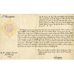
(St. Kitts) Appointment of Charles Andrew Mills as the Aid-de-Camp. . .
Unique and rare document: Describes the appointment of Charles Andrew Mills as the Aid-de-Camp (ADC and government representative) of the Caribbean island of St. Christ...
Date: Antigua, 1806
Selling price: ????
Please login to see price!
Sold in 2016
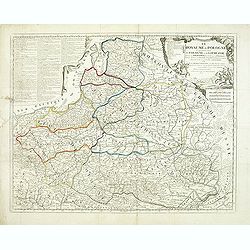
Le ROYAUME de POLOGNE Comprenant les Etats de Pologne et de Lithuanie, divisez en Province et Subdivisez en Palatinats. . .
Extends from about Vienna in the west to east of the Crimea and north to include the present day Baltic States. It includes all of the present day Ukraine. The map was fi...
Date: Paris, ca. 1742 - 1806
Selling price: ????
Please login to see price!
Sold in 2012
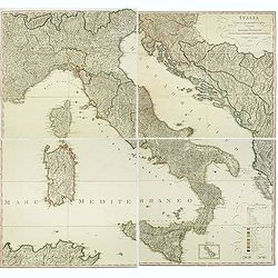
Italia Divisa ne' suoi Presenti Confini, disegnata da Ignazio Heymann Ufficiale nel Imp: & Ces: Reg: Supremo Uffizio delle Poste in Trieste. E divulgata a sue spese 1806.
Folding wall map showing Italy with Corsica, Sardinia and Sicily, Istria and the Dalmatian coast. Drawn, engraved and published by I. Heymann, Austrian geographer and dir...
Date: Trieste, Ignazo Heymann, 1806
Selling price: ????
Please login to see price!
Sold in 2016
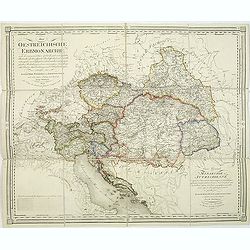
Die Oestreichische Erbmonarchie nach ihrem gegenwärtigen Zustande Kartenmaterial mit vorzüglicher Rücksicht auf ihre physische Beschaffenheit. . . / Carte générale de la monarchie autrichienn.
Detailed map showing Central Europe and showing the Austria-Hungarian Monarchy. The map includes Austria, with parts of Poland, Germany, Italy, prepared by Joseph Wüstin...
Date: Vienna, Kunst und Industrie Comptoirs,1806
Selling price: ????
Please login to see price!
Sold in 2013
![Morokoshi Meisho Zue [Illustrated Description of Famous Sites of China].](/uploads/cache/93014-250x250.jpg)
Morokoshi Meisho Zue [Illustrated Description of Famous Sites of China].
Published : Osaka, Kawachiya Genhichiro, et al.[8 book sellers], slightly later issue but apparently in Edo period, using all the same woodblocks of original first editi...
Date: Osaka, Bunka 3 or1806
Selling price: ????
Please login to see price!
Sold in 2013
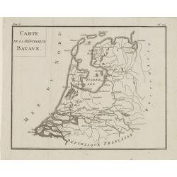
Carte de la République BATAVE.
Uncommon map of the Batavian Republic, published in the year of the Treaty on May 24th 1806 between France and the Batavian Republic.From Atlas de géographie du toutes p...
Date: Paris, Prudhomme, Levrault, Debray, 1806
Selling price: ????
Please login to see price!
Sold in 2020
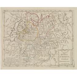
La Russie d'Europe Divisée par Gouvernemens.
Map of European Russia, centered on Moscow. From Atlas de la Géographie de toutes les parties du monde .. Ouvrage destiné pour l'education, et nécessaire aux négocian...
Date: Paris, Prudhomme, Levrault, Debray, 1806
Selling price: ????
Please login to see price!
Sold in 2013
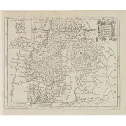
Les Couronnes du Nord, Comprenant les Royaumes de Suède, Norwege et Danemarck.
Map of Scandinavia, from Atlas de la Géographie de toutes les parties du monde .. Ouvrage destiné pour l'education, et nécessaire aux négocians, aux voyageurs, aux fo...
Date: Paris, Prudhomme, Levrault, Debray, 1806
Selling price: ????
Please login to see price!
Sold in 2018
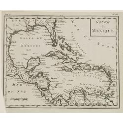
Golfe du Mexique.
Map of Central America, including Greater and Lesser Antilles. From Atlas de la Géographie de toutes les parties du monde .. Ouvrage destiné pour l'education, et néces...
Date: Paris, Prudhomme, Levrault, Debray, 1806
Selling price: ????
Please login to see price!
Sold in 2018
Le Royaume de Hongrie et la Turquie d'Europe.
Map of south eastern Europe centered on Greece and the Aegean Sea. From Atlas de la Géographie de toutes les parties du monde .. Ouvrage destiné pour l'education, et n�...
Date: Paris, Prudhomme, Levrault, Debray, 1806
Selling price: ????
Please login to see price!
Sold in 2020
Dernier Partage de la Pologne Effectué en 1795, entre la Russie, la Prusse et l'Empire d'Allemagne.
Map of Poland, from Atlas de la Géographie de toutes les parties du monde .. Ouvrage destiné pour l'education, et nécessaire aux négocians, aux voyageurs, aux fonctio...
Date: Paris, Prudhomme, Levrault, Debray, 1806
Selling price: ????
Please login to see price!
Sold in 2014
Carte du Royaume Unis d'Irlande.
Map of Ireland, from Atlas de la Géographie de toutes les parties du monde.. Ouvrage destiné pour l'education, et nécessaire aux négocians, aux voyageurs, aux fonctio...
Date: Paris, Prudhomme, Levrault, Debray, 1806
Selling price: ????
Please login to see price!
Sold in 2014
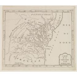
Carte de la Virginie et du Mariland.
Map centered on Chesapeake Bay and its hinterland, from Atlas de la Géographie de toutes les parties du monde.. Ouvrage destiné pour l'education, et nécessaire aux né...
Date: Paris, Prudhomme, Levrault, Debray, 1806
Selling price: ????
Please login to see price!
Sold in 2017
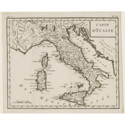
Carte d'Italie.
Map of Italy, including Sicily, Sardinia and Corsica. From Atlas de la Géographie de toutes les parties du monde.. Ouvrage destiné pour l'education, et nécessaire aux ...
Date: Paris, Prudhomme, Levrault, Debray, 1806
Selling price: ????
Please login to see price!
Sold in 2014
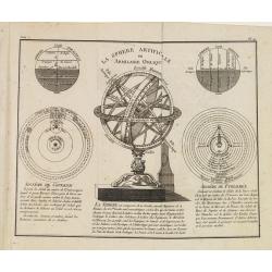
La Sphere Artificielle ou Armilaire Oblique.
At the center of the map an armillary sphere surrounded by the parallel and right sphere, the representation of the Copernican and Ptolemaic system.From Atlas de la Géog...
Date: Paris, Prudhomme, Levrault, Debray, 1806
Selling price: ????
Please login to see price!
Sold in 2013
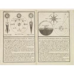
Démonstration de quelques effets du Soleil et de la Lune, et des principaux objets de l'Aréologie.
Representation of lunar phases, eclipses and other phenomenons, with explanatory text in the lower half of the engraving.From Atlas de la Géographie de toutes les partie...
Date: Paris, Prudhomme, Levrault, Debray, 1806
Selling price: ????
Please login to see price!
Sold in 2013
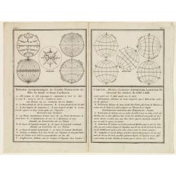
Division Astronomique du Globe Terrestre en Cercles, Zones, Climats..
Representation of several spheres illustrating the climatic areas, parallels, meridians etc.From Atlas de la Géographie de toutes les parties du monde .. Ouvrage destin�...
Date: Paris, Prudhomme, Levrault, Debray, 1806
Selling price: ????
Please login to see price!
Sold in 2013
Judée ou Terre Sainte.
Map of the Holy Land, Judea. By C. F. Delamarche, successor of Robert de Vaugondy, Geographer.
Date: Paris, 1794 -1806
Selling price: ????
Please login to see price!
Sold in 2021
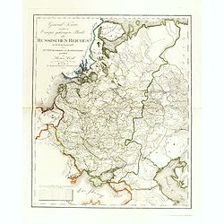
General Karte von dem zu Europa gehörigen Theile des Russischen Reiches nach dem Entwürfe des Hrn. J. M. Freyherrn von Lichtenstern. . .
Uncommon and detailed map of European Russia, with Lithuania, Latvia, Estonia, Balarus and Ukraine. According to the title design of H. Joseph Marx, Baron of Liechtenster...
Date: Vienna, Verlage des Kunst und Industrie Comptoir, 1806
Selling price: ????
Please login to see price!
Sold in 2014
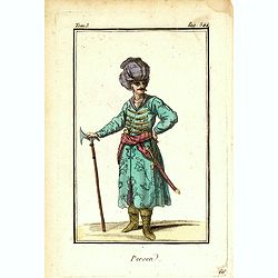
Persen.
Originally hand-colored mezzotint of a Persian man dressed in native garb, engraved by Félix Mixelle and Lachaussée Jeune after Jacques Grasset de Saint-Sauveur.As an e...
Date: Paris,1801-1806
Selling price: ????
Please login to see price!
Sold in 2016
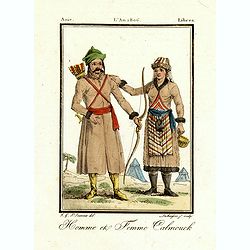
Homme et femme Calmouck.
Originally hand-colored mezzotint of two men from the autonomous Republic of Kalmykia dressed in native garb, engraved by Félix Mixelle and Lachaussée Jeune after Jacqu...
Date: Paris,1801-1806
Selling price: ????
Please login to see price!
Sold in 2016
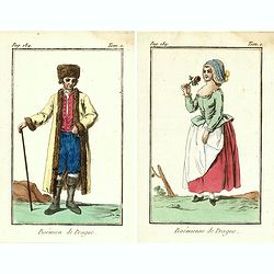
Bohémienne / Bohémien de Prague. (2 prints)
Two originally hand-colored mezzotints of citizens of Prague engraved by Félix Mixelle and Lachaussée Jeune after Jacques Grasset de Saint-Sauveur.As an etcher, drawer ...
Date: Paris,1801-1806
Selling price: ????
Please login to see price!
Sold in 2016
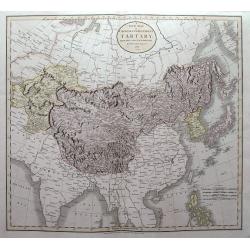
A New Map of Chinese Independent Tartary, from the Latest Authorities.
Map that displays Independent and Chinese Tartary, with present-day China, Tibet, Mongolia, Japan, South Korea, Taiwan, Kazakhstan, Uzbekistan, Turkmenistan, Iran,... Hig...
Date: London, 1806
Selling price: ????
Please login to see price!
Sold in 2015

Napoleon 1er Empereur des Français.
Fine full length in uniform, with chapeau, head to right, on a prancing horse, advancing to the left, at the head of his staff, on the field of battle. Engraved by Pierre...
Date: Paris, ca. 1806
Selling price: ????
Please login to see price!
Sold in 2016
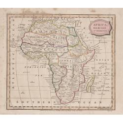
Africa, from the Best Authorities
“Africa, from the Best Authorities”. An attractive small map of the whole of Africa, engraved by James Barlow, with original hand coloring.Published by C. Brightly, a...
Date: Bungay, 1806
Selling price: ????
Please login to see price!
Sold in 2017