Browse Listings
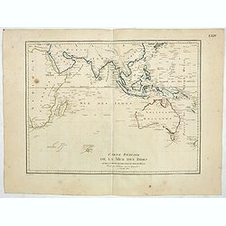
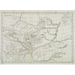
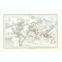
Carte reduite de la Mer des Indes et de la partie occidentale du Grand Océan. (Page XXIV)
Uncommon map of the Indian Ocean, Australia and the East Coast of Asia, showing still an incomplete coastline for Australia and New Guinea, among other features. The map ...
Date: Paris, 1803
Selling price: ????
Please login to see price!
Sold in 2019
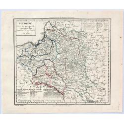
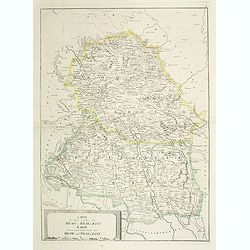
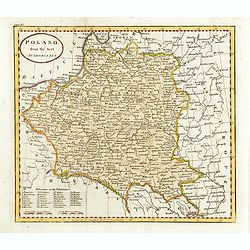
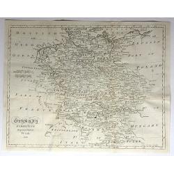
Pologne avec les Partages de 1792, 1793 et 1795 . . .
A striking map of Poland, Lithuania and Prussia with notes on the region. The notes within the map show the acquisitions of Russia in Poland in 1773 and 1795, totaling 14...
Date: Paris, 1803
Selling price: ????
Please login to see price!
Sold in 2019
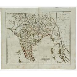
Carte de L'Inde.
A scarce engraved map of the Indian subcontinent covering India and including parts of Iran (Perse), Afghanistan (Royaume de Candahar), Tibet, China, and Indochina (Empir...
Date: Paris, 1803
Selling price: ????
Please login to see price!
Sold in 2021
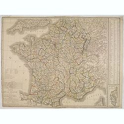
Carte de la France divisée en 108 departemens. . .
General map of France, showing a road-system and 108 departments. In lower right inset map of Corsica (140x70mm.) The map is dated 1804 and "An 12" being the 12...
Date: Paris, An 12 / 1804
Selling price: ????
Please login to see price!
Sold
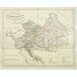
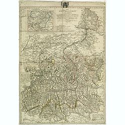
Allgemeine Charte zur Uebersicht der Kirchlichen Verfassung des oesterreichischen Staates = Carte eccle´siastique de la monarchie autrichienne : mit Bemerkung aller Erzbisthu¨mer. . .
Detailled map showing Central Europe and showing the Austria-Hungarian Monarchy. The map includes Austria, with parts of Poland, Germany, Italy, prepared by Karl Joseph K...
Date: Vienna, Kunst und Industrie Comptoirs,1804
Selling price: ????
Please login to see price!
Sold in 2013
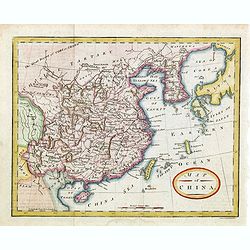
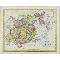
Map of China.
Showing China, Taiwan and Korea, divided into provinces with the main cities marked. The map is of interest for the naming of the sea between Korea and Japan, here called...
Date: London, 1804
Selling price: ????
Please login to see price!
Sold in 2014
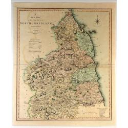
A New Map of the County of Northumberland Divided into Wards.
Handsome and detailed county map shows market towns with distances from London in measured miles. The major canals, roads, railways, parks and churches are also clearly m...
Date: London, 1804
Selling price: ????
Please login to see price!
Sold in 2018
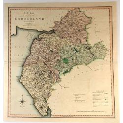
A New Map of the County of Cumberland
Handsome and detailed county map shows market towns with distances from London in measured miles. The major canals, roads, railways, parks and churches are also clearly m...
Date: London, 1804
Selling price: ????
Please login to see price!
Sold in 2017
A Map of the Dutchy of Holstein with the Territories of the Imperial Towns Hamburg and Lübek, Also the Bishoprick of Eutin...
A Map of the Dutchy of Holstein with the Territories of the Imperial Towns Hamburg and Lübek also the Bishoprick of Eutin…A pleasing map of the Duchy of Holstein, with...
Date: London, 1804
Selling price: ????
Please login to see price!
Sold in 2016
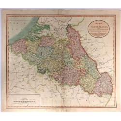
A New Map of the Netherlands, Also Of that part of Germany Westward of the Rhine
A detailed map of John Cary’s Netherlands, from the important early 19th century “NEW UNIVERSAL ATLAS”. It covers from Dunkirk eastward as far as the German border....
Date: London, 1804
Selling price: ????
Please login to see price!
Sold in 2017
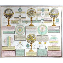
Tableau Analytique des Differentes Positions de la Sphere
A fine, large chart by Charles Francois Delamarche (1740-1817) that explains the different theories of the solar system, according to Copernicus, Tycho Brahe and Ptolemy....
Date: Paris, 1804
Selling price: ????
Please login to see price!
Sold in 2016
System de Copernic ou Abrege de l'Astrononie.
A large detailed chart of Copernicus' theory of the solar system surrounded with descriptive panels of French text. The outermost planet is noted as Herschel, the first p...
Date: Paris, 1804
Selling price: ????
Please login to see price!
Sold in 2017
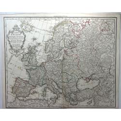
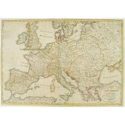
Carte D'Europe Dressee pour L'Instruction. . .
A striking example of Dezauche's revised edition of Delisle's map of Europe. With a new decorative cartouche, which was replaced after the French Revolution to remove th...
Date: Paris, 1804
Selling price: ????
Please login to see price!
Sold in 2018
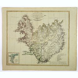
Island nach Murdochisher Projection. . .
An unusual, odd looking map of Iceland, based on Patrick Murdoch's projection of the previous century. As a result the island of Iceland looks 'shortened' or 'compacted'....
Date: Weimar, 1804
Selling price: ????
Please login to see price!
Sold in 2018

Edinburg.
An interesting city view of Edinburg, Scotland with a group of three prints below in German that translate to "Unexpected arrest of the chemist's famous Franz Genera...
Date: Unknown, 1804
Selling price: ????
Please login to see price!
Sold in 2019
![[no title] Map of the United States and southern Canada.](/uploads/cache/44308-250x250.jpg)
[no title] Map of the United States and southern Canada.
This untitled map of the United States and southern Canada bears the imprimatur Smith & Jones Sculp. 13 Pleasant Row Pentonville (McCorkle #799.8). It is from an Engl...
Date: London, R.Philips, 1804
Selling price: ????
Please login to see price!
Sold in 2020

Map of China.
Showing China, Taiwan and Korea, divided into provinces with the main cities marked. The map is of interest for the use of Sea of Corea, the sea between Korea and Japan, ...
Date: London, 1804
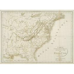
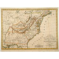
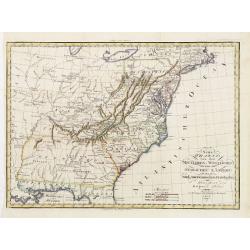
Carte des Etats du centre, de L'Quest et du Sud des Etats-Unis.
Detailed map of the East Coast of America. Engraved by S.Glot.
Date: Paris, ca. 1804
Selling price: ????
Please login to see price!
Sold
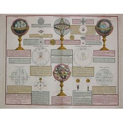
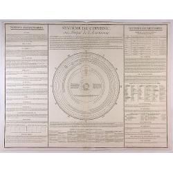
TABLEAU ANALYTIQUE des différentes positions de la Sphère, des diff'rents systèmes, des révolutions et des distances des Planètes, &c.
Charles François Delamarche (1740-1817), Paris-based geographer and publisher, successor to Didier Robert de Vaugondy after his death in 1786.Attractive print with a cel...
Date: Paris, 1804
Selling price: ????
Please login to see price!
Sold
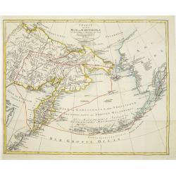
Charte von dem Meer von Kamtschatka mit Capt. Jos. Billings und Mart. Sauers Reise Routen..
Uncommon map of the west coast of America showing the tracks of Billings and Sauers.Prepared by Ferd Götze.
Date: Weimar 1804
Selling price: ????
Please login to see price!
Sold
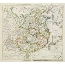
Charte von China..
Uncommon map of China prepared by H.F.A.Stieler, giving good detail of the region and extending as far as Taiwan and the Korean peninsula.With inset map of the Ryukyu Isl...
Date: Weimar 1804
Selling price: ????
Please login to see price!
Sold

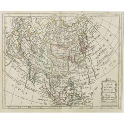
L'Asie.
Map of Asia. By C. F. Delamarche, successor of Robert de Vaugondy, Geographer.
Date: Paris, 1804
Selling price: ????
Please login to see price!
Sold in 2016
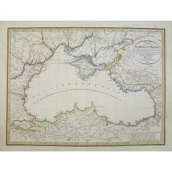
Charte des Schwarzen-Meeres. Nach Murdochischer Projection entworfen und nach den neuesten astronomischen Ortsbestimmungen berichtigt auf der Sternwarte Seeberg bey Gotha. Gezeichnet von Ferd. Götze.
Uncommon map of the Black Sea and surrounding regions. It comprises the region from Wosnesensk to the North to Siwas to the South, from Silistria to the West to Skurali t...
Date: Weimar, 1804
Selling price: ????
Please login to see price!
Sold in 2009
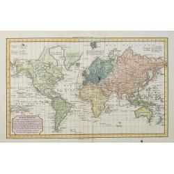
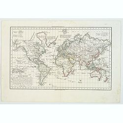
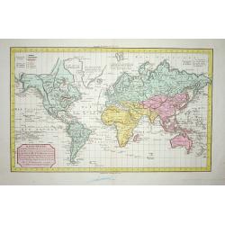
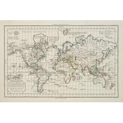
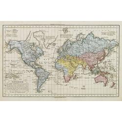
MAPPE-MONDE ou CARTE GENERALE de toutes les parties du GLOBE, corrigée et augmentée des Découvertes du Cap. COOK, de celles de la PEROUSE en 1801, de VANCOUVER, de MACKENSIE en 1802 . . .
World map with relief shown pictorially of all areas of the globe discovered by Captain Cook and Pérouse in 1801 as well as by Vancouver and Mackensie in 1802.
Date: Paris, 1804
Selling price: ????
Please login to see price!
Sold
Neu berichtigte Charte von dem Lande der Kirgisen von der Grossen Horde und der südlich angränzenden volker nach einer Russischen Handzeichnung.
An uncommon and finely rendered map of a virtually unknown area.
Date: Weimar, 1804
Selling price: ????
Please login to see price!
Sold in 2009
Map of China.
Showing China, Taiwan and Korea, divided into provinces with the main cities marked. The map is of interest for the use of East Sea, the sea between Korea and Japan, here...
Date: London, 1804
Selling price: ????
Please login to see price!
Sold
Carte des deux Cercles de Brody et Brzeczany. Karte deren zween Kreisen von Brody und Brzeczany.
Detailed map of part of Poland from the rare atlas Atlas des Roiaumes de Galicie et de Lodomerie consistant en une Carte générale de ces deux Roiaumes et 10 Cartes. . ....
Date: Vienna, 1798-1804
Selling price: ????
Please login to see price!
Sold in 2011
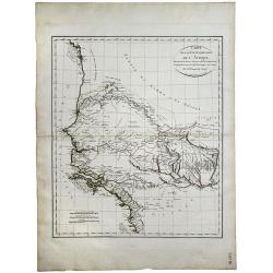
Carte de la Cote Ociidentale de l' Afrique.
A map showing the west Africa coasts, from Sierra Leone to Senegal and Gambia. Engraved by Tardieu. Shows all the up to then explored areas in the region.
Date: Paris, 1804
Selling price: ????
Please login to see price!
Sold in 2020
Mappe-Monde ou Carte Générale de toutes les parties du Globe. . .
A world map on Mercator's projection, the map is divided into 4 parts according to religion: Judaism, Christianity, Islam and Paganism. This map is improved after the dis...
Date: Paris, ca 1804
Selling price: ????
Please login to see price!
Sold in 2020
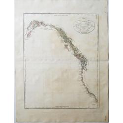
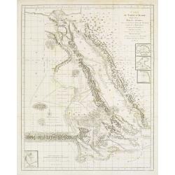
Carte de la Partie de la Cote Nord-Ouest de l'Amerique Reconnue pendant les Etes de 1792, 1793 et 1794 . .
A Cartographic Landmark -- George Vancouver's Map of the West Coast of North America. The first broadly accurate sea chart of the Pacific Coast of North America, by the g...
Date: Paris , 1804
Selling price: ????
Please login to see price!
Sold in 2021
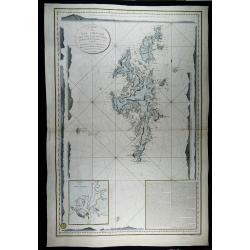
Carte des iles Shetland, d'après le plan du Cap. Anglais Preston, rectifié par M. de Lowenorn en 1787, Dépôt de La Marine, l'an XIII
Rare and very large and detailed nautical chart of the Shetland Islands, published in 1804 (year 13 of the French Revolution) by the French Ministry of the Navy, after th...
Date: Paris, 1787 / 1804
Selling price: ????
Please login to see price!
Sold in 2023
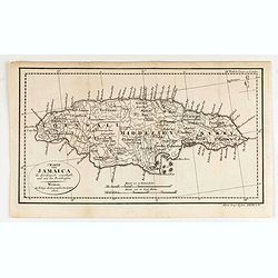
Charte von Jamaica In Kirchspiele eingetheilt und mit den Poststrassen.
General map of Jamaica, shows the postal roads, churches, towns, harbours, rivers, mountains and many other details. One of the earliest obtainable maps of Jamaica to loc...
Date: Weimar, 1805
Selling price: ????
Please login to see price!
Sold in 2020
Asia Florente Persarum Imperio.
An early nineteenth century map of Asia covering the regions of Asia Minor and the Black Sea, the Balkans, the Middle East, Ethiopia, Persia, Tartary, Siberia, India and ...
Date: Göttingen, 1805
Selling price: ????
Please login to see price!
Sold in 2021
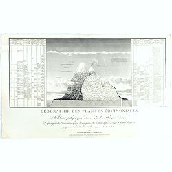
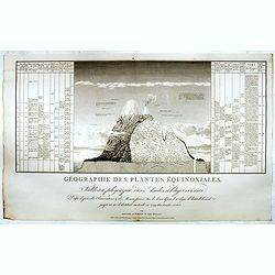
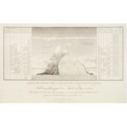
Géographie des Plantes Equinoxiales - Tableau physique des Andes et pays voisins..
"Physical Portrait of the Andes and adjacent lands", organized around the Chimborazo and Cotopaxi volcanoes, in Ecuador.With local vegetation illustrates pictor...
Date: Paris, 1805
Selling price: ????
Please login to see price!
Sold in 2021
Generalcharte von Australien nach dem Entwurfe des K.Joseph Marx Freiherrn v. Lichtenstein. . .
The map features the islands of the Pacific and Australia which is named "Neu Holland vormals Ulimaroa" on its western half and in the eastern half "Neu S�...
Date: Vienna, Kunst- und Industrie-Comptoirs, 1805
Selling price: ????
Please login to see price!
Sold in 2022
Géographie des Plantes Equinoxiales - Tableau physique des Andes et pays voisins..
"Physical Portrait of the Andes and adjacent lands", organized around the Chimborazo and Cotopaxi volcanoes, in Ecuador.With local vegetation illustrates pictor...
Date: Paris, 1805
Selling price: ????
Please login to see price!
Sold in 2014
Das Kurfüstenthum Salzburg. . .
Map of Salzburg in Austria. Many annotation in black lead-pencil. More about folding maps. [+]
Date: Nurmberg, 1805
Selling price: ????
Please login to see price!
Sold in 2013
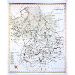
Cambridgeshire from the Best Authorities.
Detailed map of Cambridgeshire published by John Stockdale in Piccadilly. Nice presentation of roads mountains and rivers. It features the cities of Cambridge, Caxton, El...
Date: London, 1805
Selling price: ????
Please login to see price!
Sold in 2016

Umriss des Schwarzen Meeres des Bosphorus, des Propontes, des Hellesponts, des Archipelagus nebst den Küsten / nach den neuesten Bericht von D.F. Sotzmann 1803
Scarce map of the Black Sea, with inset map of the Sea of Marmara and four views of the fortifications of the Dardanelles Strait (Turkey).Published in "Gallerie der ...
Date: Berlin, Oehmigke, 1805
Selling price: ????
Please login to see price!
Sold in 2013
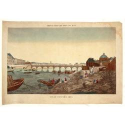
Vue du Pont des Arts.
Fine Vue Optique featuring the neighbourhood close to the Louvre. The bridge was the first iton bridge in Paris. Unlike most Vue Optique prints, the hand-coloring on this...
Date: Paris, 1805
Selling price: ????
Please login to see price!
Sold in 2019
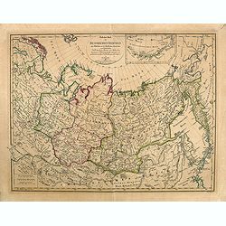
Östlicher Theil des Russischen Reiches oder Sibirien mit den Kurilischen, Aleutischen und Fuchs-Inseln. . .
Scarce map of Eastern part of Russia, prepared by F.L. Güssefeld and published by Homann Heirs.Engraved by I.B.Slbrig.
Date: Nuremberg, ca. 1805
Selling price: ????
Please login to see price!
Sold in 2014
Géographie des Plantes Equinoxiales - Tableau physique des Andes et pays voisins..
"Physical Portrait of the Andes and adjacent lands", organized around the Chimborazo and Cotopaxi volcanoes, in Ecuador.With local vegetation illustrates pictor...
Date: Paris, 1805
Selling price: ????
Please login to see price!
Sold in 2015
Poland from the best authorities.
Detailed map of Poland from "A New Geographical, Historical, and Commercial Grammar", by William Guthrie. William Guthrie (later engraver for Carey) London, UK....
Date: London, 1805
Selling price: ????
Please login to see price!
Sold in 2015
Mappe-Monde ou Carte Generale de toutes les Parties connues..
The map is divided into 4 parts according to religion : Judaism, Christianity, Islam and Paganism. This map is improved after the discoveries of Cook, de la Perouse, Vanc...
Date: Paris ca.1805
Selling price: ????
Please login to see price!
Sold in 2018
A MAP OF MIDDLESEX FROM THE BEST AUTHORITIES 1805
A detailed copper engraved map of the county of Middlesex by John Cary. The map was produced to accompany Richard Gough’s new edition of Camden’s Britannia and publis...
Date: London, 1805
Selling price: ????
Please login to see price!
Sold in 2017
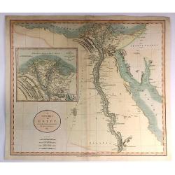
A new Map of Egypt From the Latest Authorities.
A striking example of this detailed map of Egypt, the Gulf of Suez, Red Sea and the Course of the Nile, with a large inset of the Nile Delta. Published by John Cary in Lo...
Date: London, 1805
Selling price: ????
Please login to see price!
Sold in 2017
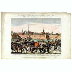
Entrée triomphale de la grande armée française commandée par Napoléon-le-Grand dans la ville de Vienne, capitale de l'Autriche le 13 novembre 1805.
Arrival of Napoleon in Vienna on 13 November 1805. With address "A Paris chez Basset M.d d'estampes et fabricant de papiers peints, Rue S.t-Jacques au coin de celle ...
Date: Paris, ca. 1805
Selling price: ????
Please login to see price!
Sold in 2016
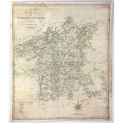
A Map of Worcester from the Best Authorities
A detailed and large map of Worcester, engraved by John Cary, for publication in Richard Gough's translation of William Camden's 'Britannia' in 1789. This edition was pu...
Date: London, 1805
Selling price: ????
Please login to see price!
Sold in 2017
Géographie des Plantes Equinoxiales - Tableau physique des Andes et pays voisins. . .
"Physical Portrait of the Andes and adjacent lands", organized around the Chimborazo and Cotopaxi volcanoes, in Ecuador.With local vegetation illustrates pictor...
Date: Paris, 1805
Selling price: ????
Please login to see price!
Sold in 2018
Germany Exhibiting the Present Seat of War, 1805.
A detailed map of Europe, highlighting the position of the war in and around Germany as at 1805. It covers and area from Denmark in the north Turkey in the south, from Fr...
Date: Germany, 1805
Selling price: ????
Please login to see price!
Sold in 2017
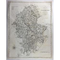
A Map of Staffordshire from the Best Authorities.
An attractive and detailed late 18th century map of Staffordshire, engraved by John Cary and published by Stockdale in Richard Gough's new translation of Camden's Britann...
Date: London, March 1805
Selling price: ????
Please login to see price!
Sold in 2018

Paysane du marquisat de Bade.
Originally hand-colored mezzotint from 'Costumes civils actuels de tous les peuples connus'. After Jacques Grasset de Saint-Sauveur. As an etcher, drawer and writer, Gras...
Date: Paris,1805
Selling price: ????
Please login to see price!
Sold in 2017
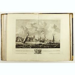
Atlas van de Zeehavens der Bataafsche Republiek, die van Batavia en Onrust. Mitsgaders der Afbeeldingen van de Haringvisscherij en de Walvischvangst..
Illustrated with a fine series of views of Dutch harbours, including two plates depicting Herring and Whale fishing scenes not included in the first edition of 1802.1. De...
Date: Amsterdam, E. Maaskamp, 1805
Selling price: ????
Please login to see price!
Sold in 2018

MATRIMONIAL - HARMONICS.
An unhappily married couple torment each other in the breakfast-room. Inscription beneath "Js. Gillray. des. & ft. / London. Publish'd. October 25th. 1805, by H....
Date: London 1805
Selling price: ????
Please login to see price!
Sold in 2018
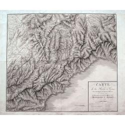
Carte de la Rivière de Gênes, Pour l'Intelligence des Opérations Militaires de 1792 à 1800...Montenotte et Mondovi en 1796.
A rare large scale map of Liguria and Piedmont from Alassio until Genoa. Extending until Fossano, Alba, Acqui Terme, and Novi Ligure in the north. The highly detailed map...
Date: France, ca. 1805
Selling price: ????
Please login to see price!
Sold in 2018
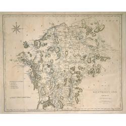
Map of Westmorland from the Best Authorities.
A finely engraved, highly detailed map by Cary, showing Ullswater, Windermere, etc. From Camden's 'Britannia' in 1789. John Cary (1754-1835) was an English cartographer, ...
Date: London, 1805
Selling price: ????
Please login to see price!
Sold in 2019
![[Early folding promotial fan with map of Martin La Bastide and his project to join the Pacific Ocean and the Atlantic Ocean.]](/uploads/cache/44026-250x250.jpg)
[Early folding promotial fan with map of Martin La Bastide and his project to join the Pacific Ocean and the Atlantic Ocean.]
The fan is decorated on one side with an engraved map showing Central America and Lake Nicaragua. In the upper part is a long text on the work of Martin La Bastide and hi...
Date: France, ca. 1805
Selling price: ????
Please login to see price!
Sold in 2020
Neue Charte von dem Mittleren Westlichen .. Nord Amerika..
A very nice map centered on north America, including part of Florida, north and south Carolina, Pennsylvania, etc. Title cartouche on the lower right corner.
Date: Weimar 1805
Selling price: ????
Please login to see price!
Sold
Charte Itineraire de l'Europe pour le guide des Voyageurs..
Uncommon road map of Europe. Prepared for the travel guide of Reichard, prepared by Güssefeld. Engraved by Frentzel.
Date: Weimar 1805
Selling price: ????
Please login to see price!
Sold
Mappe-Monde ou carte Generale..
The map is divided into 4 parts according to religion : Judaism, Christianity, Islam and Paganism. This map is improved after the discoveries of Cook, de la Perouse, Vanc...
Date: Paris ca.1805
Selling price: ????
Please login to see price!
Sold
Mappe-Monde ou Carte Generale de toutes les Parties connues..
The map is divided into 4 parts according to religion : Judaism, Christianity, Islam and Paganism. This map is improved after the discoveries of Cook, de la Perouse, Vanc...
Date: Paris ca.1805
Selling price: ????
Please login to see price!
Sold
Golphe D'Arabie,.. Bab-el-Mandeb, ..
Detailed map of the Red Sea, here called Golfe d'Arabie, showing tracks of Poncet and James Bruce. Giving good detail along the coast of Saudi Arabia. From Voyages de Bru...
Date: Paris 1805
Selling price: ????
Please login to see price!
Sold in 2014
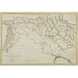
Neue Charte von den Mittleren, Westlichen und Südlichen Ländern der Nord-Americanischen Freistaaten..
A detailed and rare map covering good part of the central and eastern American States.
Date: Weimar 1805
Selling price: ????
Please login to see price!
Sold
Charte von Syrien, Mesopotamien und einem Theile von Persien. . .
Map of Persia , Syria and Mesopotamia. German edition taken from the French edition Atlas pour servir au voyage dans l'Empire Othoman. . . that was published in Paris f...
Date: Weimar, 1805
Selling price: ????
Please login to see price!
Sold in 2009
Géographie des Plantes Equinoxiales - Tableau physique des Andes et pays voisins..
''Physical Portrait of the Andes and adjacent lands'', around the Chimborazo and Cotopaxi volcanoes, in Equador.With local vegetation illustrates pictorially on the left ...
Date: Paris, 1805
Selling price: ????
Please login to see price!
Sold in 2009
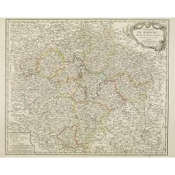
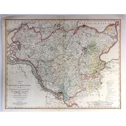
Royaume de Boheme divise en douze cercles. . .
Uncommon general map of the Czech Republic, centered on Prague. Prepared after a map of Johann Christoph Müller (1673-1721), who was a Austrian cartographer.Uncommon lat...
Date: Paris, dated 1805
Selling price: ????
Please login to see price!
Sold in 2014
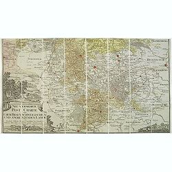
Neu vermehrte post charte der chur Braunschweigischen und angrenzenden lande. . . Von Friedrich Wilhelm Ohsen, ... privatim entworfen im Jahre 1774, verbessert 1805.
Unfortunately only the lower half of a post road maps map of North-Western Germany, centered on Braunsschweig.Prepared by Friederich Wilhelm Ohsen in 1774 and updated for...
Date: Hannover, 1774 - 1805
Selling price: ????
Please login to see price!
Sold in 2018
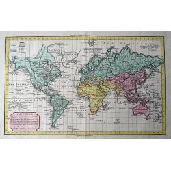
MAPPE-MONDE ou CARTE GENERALE de toutes les parties du GLOBE, MAPPE-MONDE ou CARTE GÈNÈRALE de toutes les parties du GLOBE, corrigée et augmentée des Découvertes du Cap. COOK, de celles de la PEROUSE en 1801, de VANCOUVER, de MACKENSIE en 1802...
Attractive world map in Mercator projection, including the latest discoveries of Capt. Cook, Pérouse (1801), Vancouver and Mackensie (1802). After Robert de Vaugondy. W...
Date: Paris, 1805
Selling price: ????
Please login to see price!
Sold in 2011
Carte d'Asie . . .
Map of the Asian continent. The map is of interest for the use of East Sea, the sea between Korea and Japan, here called "Mer de Corée".from Atlas moderne port...
Date: Paris, Prudhomme, Levrault, Debray, 1806
Selling price: ????
Please login to see price!
Sold

Entrée des Français à Berlin, le 27 Octobre 1806.
Engraving representing Napoleon and his troops in front of the Brandenburg Door.
Date: Paris, ca. 1806
Selling price: ????
Please login to see price!
Sold in 2008
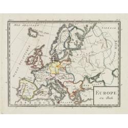
Europe en 1806.
Map of Europe, from Atlas de la Géographie de toutes les parties du monde .. Ouvrage destiné pour l\'education, et nécessaire aux négocians, aux voyageurs, aux foncti...
Date: Paris, Prudhomme, Levrault, Debray, 1806
Selling price: ????
Please login to see price!
Sold in 2009
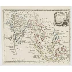
Les Indes Orientales et leur Archipel..
Map of South Eastern Asia, encompassing the area between India and Indonesia.From Atlas de la Géographie de toutes les parties du monde .. Ouvrage destiné pour l\'educa...
Date: Paris, Prudhomme, Levrault, Debray, 1806
Selling price: ????
Please login to see price!
Sold in 2008
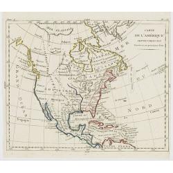
Carte de l'Amérique Septentrionale Divisée en ses principaux Etats.
Map of North and Central America. From Atlas de la Géographie de toutes les parties du monde .. Ouvrage destiné pour l'education, et nécessaire aux négocians, aux voy...
Date: Paris, Prudhomme, Levrault, Debray, 1806
Selling price: ????
Please login to see price!
Sold in 2023
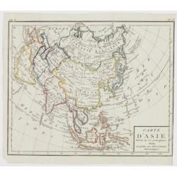
Carte d\'Asie Divisée en ses principaux Etats..
Map of Asia, from Atlas de la Géographie de toutes les parties du monde .. Ouvrage destiné pour l\'education, et nécessaire aux négocians, aux voyageurs, aux fonction...
Date: Paris, Prudhomme, Levrault, Debray, 1806
Selling price: ????
Please login to see price!
Sold in 2009
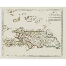
L'Isle St. Domingue Divisée en 5 Département.
Map of the island of Hispaniola, from Atlas de la Géographie de toutes les parties du monde .. Ouvrage destiné pour l'education, et nécessaire aux négocians, aux voya...
Date: Paris, Prudhomme, Levrault, Debray, 1806
Selling price: ????
Please login to see price!
Sold in 2022
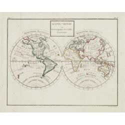
Mappe-Monde ou Description du Globe Terrestre.
Double hemisphere world map, from Atlas de la Géographie de toutes les parties du monde .. Ouvrage destiné pour l'education, et nécessaire aux négocians, aux voyageur...
Date: Paris, Prudhomme, Levrault, Debray, 1806
Selling price: ????
Please login to see price!
Sold
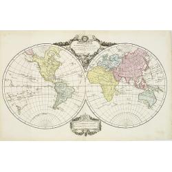
Mappe - Monde Par Robert de Vaugondy . . .
Uncommon double hemisphere world map, showing a complete outline for Australia, still called Nouvelle Hollande. With the track of Captain Cook. Published by C.F. Delamarc...
Date: Paris, 1806
Selling price: ????
Please login to see price!
Sold in 2010
Mappe-Monde ou Carte Générale de toutes les Parties connues..
World map in Mercator projection, the map is divided into 4 parts according to religion : Judaism, Christianity, Islam and Paganism. This map is improved after the discov...
Date: Paris, ca.1806
Selling price: ????
Please login to see price!
Sold in 2008
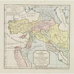
Cartes des premiers ages du monde. Géographie Ecclédiastique de la Turquie, d''Asie et de la Perse.
Map of ancient Turkey, Cyprus, Persia and Near and Middle East.By C. F. Delamarche, successor of Robert de Vaugondy, Geographer.
Date: Paris, ca.1806
Selling price: ????
Please login to see price!
Sold
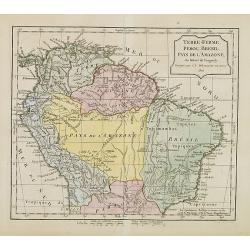
Terre-Ferme, Perou, Brésil, Pays de l'Amazone.
Map of northern half of South America, with Peru, Venezuela, Guyane and Brazil. By C. F. Delamarche, successor of Robert de Vaugondy, Geographer. Uncommon later edition, ...
Date: Paris, ca.1806
Selling price: ????
Please login to see price!
Sold in 2013