Browse Listings
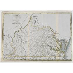
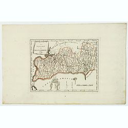
The State of Virginia from the best authorities, by Samuel Lewis. 1794.
Very detailed map of Virginia, prepared by Samuel Lewis.Engraved by Smithier and included in Carey's American Edition of Gurthries Geography.Underneath the map "engr...
Date: Philadelphia, Mathew Carey, 1795
Selling price: ????
Please login to see price!
Sold
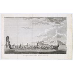
Oorlogs-Praauw van Niew-Zeeland
Shows long Maori war canoe with carved stern and prow, being rowed by about 30 men, with several men standing. Two further canoes with sails in the left background. Gable...
Date: Amsterdam, 1795
Selling price: ????
Please login to see price!
Sold in 2013
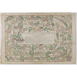
Jeu Géographique de la République française présenté à la Convention Nationale.
Educational game directed by a former professor of geography. It was intended to promote the new French departments, each represented on one of the 83 boxes with its capi...
Date: Paris, Basset, ca. 1795
Selling price: ????
Please login to see price!
Sold in 2016
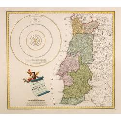
Karte von dem Konigreiche Portugal.
An attractive map of Portugal, including a representation of the solar system in the upper left-hand corner. With a charming title cartouche held by a cherub in the lower...
Date: Vienna, 1795
Selling price: ????
Please login to see price!
Sold in 2016
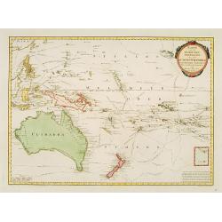
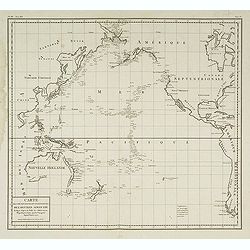
Karte von der Inselwelt Polynesien..
An attractive map of Australia, S.E.Asia, New Guinea and New Zealand showing the tracks of several explorers including those of Cook's three voyages. Australia and New Ze...
Date: Vienna 1795
Selling price: ????
Please login to see price!
Sold
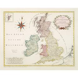
Karte von Grossbritannien und Ireland.
An attractive large sized map of Great Britain, including and inset map of the Shetland Islands in the upper left-hand corner. With a decorative title cartouche in the up...
Date: Vienna, 1795
Selling price: ????
Please login to see price!
Sold in 2011

George Washington.
Very fine steel engraving of George Washington.
Date: Amsterdam 1795
Selling price: ????
Please login to see price!
Sold
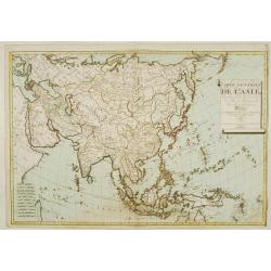
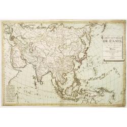
Carte générale de Asie, ou se trouvent le Découvertes des Isles, de Bougainville, surville et Dampierre..
Rare map of Asia, prepared by Hérisson after R.Bonne. Showing the tracks of Captain James Cook, and improvements after Bougainville and Dampier.
Date: Paris 1795
Selling price: ????
Please login to see price!
Sold
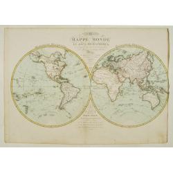
Mappe Monde en deux Hémisphéres, . . .
Handsome twin hemisphere map with particularly nice detail of the islands throughout the world. Australia is still oddly shaped with a partially delineated southern coast...
Date: Paris 1795
Selling price: ????
Please login to see price!
Sold
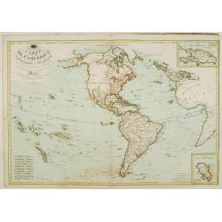
Carte de L'Amérique Septentrionale et Méridionale ou se trouvent les Découvertes les plus nouvelles..
Rare map of Asia, prepared by Hérisson after R.Bonne. Showing the tracks of Captain James Cook. Insets with the islands of Martinique and St. Domingue (Haïti)
Date: Paris 1795
Selling price: ????
Please login to see price!
Sold
PLAN OF THE CITY OF WASHINGTON, IN THE TERRITORY OF COLUMBIA...
An important and very rare, state one example of the first British printing of Washington D.C. The plan derives from John Reid's, The American Atlas. The source for both...
Date: London, 1795
Selling price: ????
Please login to see price!
Sold
Carte générale de Europe, ou L'on voit le départ et le retour du Captaine Cook, dans ses différens Voyages.
Uncommon map of Europe, prepared by Hérisson after R.Bonne. Showing the departure and return tracks of Captain James Cook.
Date: Paris 1795
Selling price: ????
Please login to see price!
Sold
Carte générale de Asie, ou se trouvent le Découvertes des Isles, de Bougainville, surville et Dampierre..
Rare map of Asia, prepared by Hérisson after R.Bonne. Showing the tracks of Captain James Cook, and improvements after Bougainville and Dampier.
Date: Paris 1795
Selling price: ????
Please login to see price!
Sold
Gedeelt van Japan of Nipon / Gezigt van de Kust van Japan.
Captain James Cook (1728-79), explorer, circumnavigator and hydrographer. Three voyages, 1768-71, 1772-75 and 1776-79. From 1778 on printed editions of ' Captain Cook's T...
Date: Amsterdam, 1795
Selling price: ????
Please login to see price!
Sold in 2019
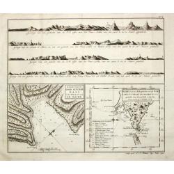
Carte de la Baye du Bon Succès dans le Détroit de le Maire./ Carte de la partie S.E. de la Terre de Feu comprenant le Détroit de le Maire et une part.ie de la Terre des Etats. 1769.
Captain James Cook (1728-79), explorer, circumnavigator and hydrographer. Three voyages, 1768-71, 1772-75 and 1776-79. From 1778 on printed editions of ' Captain Cook's T...
Date: Paris, c. 1795
Selling price: ????
Please login to see price!
Sold
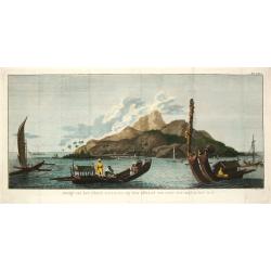
Gezigt van het eiland Otahiti op den afstand van eene zee-mijl in het Z.O.
Captain James Cook (1728-79), explorer, circumnavigator and hydrographer. Three voyages, 1768-71, 1772-75 and 1776-79. From 1778 on printed editions of' Captain Cook's Tr...
Date: Amsterdam, c. 1795
Selling price: ????
Please login to see price!
Sold
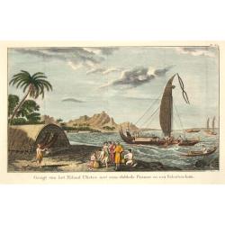
Gezigt van het Eiland Ulietea met eene dubbele Praauw en een Schuiten-huis.
Captain James Cook (1728-79), explorer, circumnavigator and hydrographer. Three voyages, 1768-71, 1772-75 and 1776-79. From 1778 on printed editions of' Captain Cook's Tr...
Date: Amsterdam, c. 1795
Selling price: ????
Please login to see price!
Sold
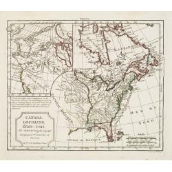
Canada, Louisiane, États-Unis. Par Robert de Vaugondy Géographé, Corrigés par le C.en Lamarche son Successeur. L'An 3.em de la République Franc?.
Two maps on one sheet. The map of the western part of North America is most notable for it's depiction of "Mer de L'Ouest" or "Sea of the West".A grea...
Date: Paris, 1795
Selling price: ????
Please login to see price!
Sold in 2016
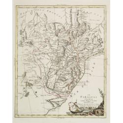
Il Paraguai Uraguai e Rio della Plata.
A finely engraved copper plate map that covers Paraguay, Uruguay and part of the contiguous countries. Good detail of the region around Buenos Ayres and the Rio de la Pla...
Date: Venise 1795
Selling price: ????
Please login to see price!
Sold
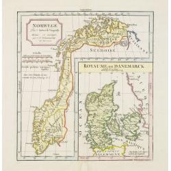
Norwege.. Royaume de Danemarck.
Attractive double page map of Norway and with a large inset map of Denmark.Original outline colors with later coulor addition.
Date: Paris 1795
Selling price: ????
Please login to see price!
Sold
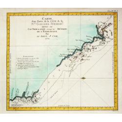
Carte d'une Partie de la Côte de la N.le galles Merid.le depuis le Cap Tribulation jusqu'au Détroit de l' Endeavour. 1770.
A chart of the northeast coast of Australia after Captain James Cook (1728-79), explorer, circumnavigator and hydrographer. Three voyages, 1768-71, 1772-75 and 1776-79. F...
Date: Paris, c. 1795
Selling price: ????
Please login to see price!
Sold
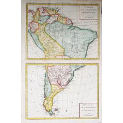
Iere / II Feuille de L' Amérique Méridionale
Louis Brion de la Tour (1756-1823), French geographer. ' Atlas Géneral, Civil et Ecclésiastique', 1766, ' Atlas Général', 1790-98.A map of South America on 2 sheets.
Date: Paris, c. 1795
Selling price: ????
Please login to see price!
Sold
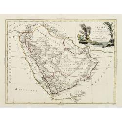
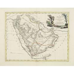
L'Arabia divisa in Petrea, Deserta e Felice.
A very striking map of the Arabian Peninsular, engraved by G.Pitteri embellished with an colored pictorial title cartouche. This edition with the date 1795.Antonio Zatta ...
Date: Venice, 1795
Selling price: ????
Please login to see price!
Sold
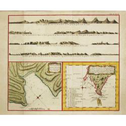
Carte de la Baye du Bon Succès dans le Détroit de le Maire./ Carte de la partie S.E. de la Terre de Feu comprenant le Détroit de le Maire et une part.ie de la Terre des Etats. 1769.
Captain James Cook (1728-79), explorer, circumnavigator and hydrographer. Three voyages, 1768-71, 1772-75 and 1776-79. From 1778 on printed editions of ' Captain Cook's T...
Date: Paris, c. 1795
Selling price: ????
Please login to see price!
Sold in 2010
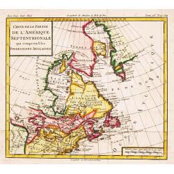
Carte de la Partie de l'Amerique Septentrionale, comprenant les Possessions Anglaises.
Louis Brion de la Tour (1756-1823), French geographer. ' Atlas Géneral, Civil et Ecclésiastique', 1766, ' Atlas Général', 1790-98. From Brunet's 'Histoire Universelle...
Date: Paris, c. 1795
Selling price: ????
Please login to see price!
Sold
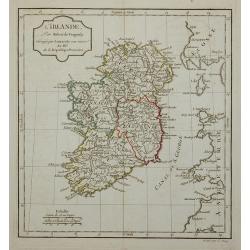
L'Irlande.
Map of Ireland, corrected by Lamarche with the mention of the year in a new cartouche : An. III.e De la République Française.
Date: Paris, 1795
Selling price: ????
Please login to see price!
Sold in 2011
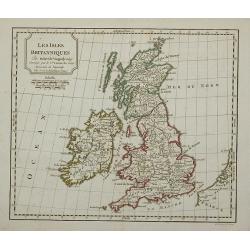
Les Isles Britanniques.
Map of the British Isles, corrected by Lamarche with the mention of the year in a new cartouche : l'an 3.me de la République Française
Date: Paris, 1795
Selling price: ????
Please login to see price!
Sold in 2011
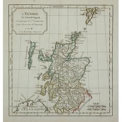
L'Ecosse.
Map of Scotland, corrected by Lamarche with the mention of the year in a new cartouche : L'An III.me de la République Française
Date: Paris, 1795
Selling price: ????
Please login to see price!
Sold in 2011
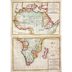
Partie de l'Afrique en deçà / au-delà de l'Equateur.
Louis Brion de la Tour (1756-1823), ' Atlas Géneral, Civil et Ecclésiastique', 1766, ' Atlas Général', 1790-98. Louis Charles Desnos (fl.1750-70), Le Rouge's 'Atlas N...
Date: Paris, c. 1795
Selling price: ????
Please login to see price!
Sold in 2008
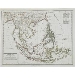
Presqu\'Île au dela du Gange et Archipel de l\'Inde.
Detailed map of Indonesia.
Date: Paris, ca 1795
Selling price: ????
Please login to see price!
Sold in 2008
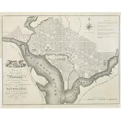
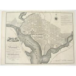
PLAN of the CITY of Washington, in the Territory of Columbia, ceded by the States of VIRGINIA AND MARYLAND to the United States of America, and by them established as the SEAT of their GOVERNMENT, after the YEAR 1800.
The famous 18th century plan of the Capital of Washington. This is the English issue of the official Thackara and Vallance plan, Philadelphia, 1792, which was made from L...
Date: London, 1795
Selling price: ????
Please login to see price!
Sold in 2009
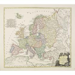
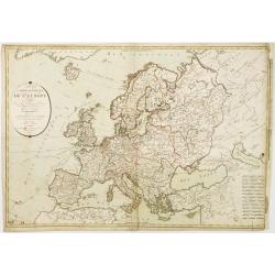
Karte von Europa.
An attractive oversized map of Europe. With a decorative title cartouche in the lower right-hand corner. Engraved by Kil. Ponheimer.Franz Johann Josef von Reilly (Vienna ...
Date: Vienna, 1795
Selling price: ????
Please login to see price!
Sold in 2012
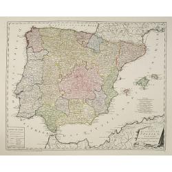
Karte von dem Konigreiche Spanien.
An attractive oversized map of Spain and Portugal. With a decorative title cartouche in the lower right-hand corner and a legend on the left side.Franz Johann Josef von R...
Date: Vienna, 1795
Selling price: ????
Please login to see price!
Sold in 2010
L'Arabia divisa in Petrea, Deserta e Felice.
A very striking map of the Arabian Peninsular, engraved by G.Pitteri embellished with an colored pictorial title cartouche.
Date: Venice, 1795
Selling price: ????
Please login to see price!
Sold in 2014
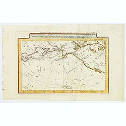
Carte des déclinaison et inclinaisons de l'aiguille aimantée. . .
Map representing the Pacific ocean with the west coast of USA and the east coast of Asiatic continent. Showing magnetic variations and an imaginary line joining the coast...
Date: Paris, c.1795
Selling price: ????
Please login to see price!
Sold in 2011
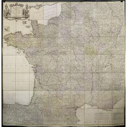
Carte de France divisée en LXXXIII departements Reduitte en neuf Feuilles égalles aux 24 Petittes de Illustre CASSINI. . .
Rare wall map of France published by Johann Michael Probst the younger (1757-1809). Prepared by Cassini.In 1747 Louis XV asked Caesar-Francois Cassini (Cassini III) to cr...
Date: Augsburg, 1795
Selling price: ????
Please login to see price!
Sold
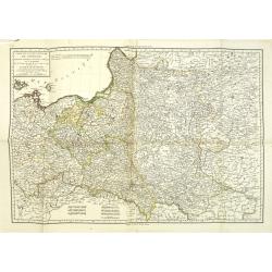
Carte de l'ancien royaume de Pologne partage entre la russie la prusse et l'Autriche. . .
Detailed map of Poland prepared by Pierre-Gilles Chanlaire (1758-1817). According to the tile the map is showing the old Kingdom of Poland, divided between the Russian, P...
Date: Paris, 1795
Selling price: ????
Please login to see price!
Sold in 2011
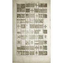
Flags of different Nations.
A full sheet of Flags, issued in London, 1795, engraved for Hall's Encyclopedia by Sidney Hall.Point of interest the Flag of the United States has only 13 stars and 7 str...
Date: London, 1795
Selling price: ????
Please login to see price!
Sold in 2012
Carte de l'ancien royaume de Pologne partage entre la russie la prusse et l'Autriche. . .
Detailed map of Poland prepared by Pierre-Gilles Chanlaire (1758-1817). According to the tile the map is showing the old Kingdom of Poland, divided between the Russian, P...
Date: Paris, 1795
Selling price: ????
Please login to see price!
Sold in 2012
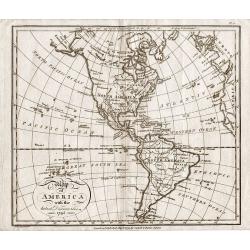
Map of America with the latest Discoveries 1795.
Map of America with the latest Discoveries 1795, by Samuel John Neele. Published May 10th 1795 by Cadell & Davies of the Strand London.Attractive small map of North a...
Date: London 1795
Selling price: ????
Please login to see price!
Sold in 2017
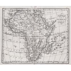
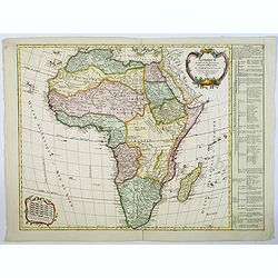
A New Map of Africa with the latest Discoveries.
A New Map of Africa with the latest Discoveries 1795 by Samuel John Neele. Published May 10th 1795 by Cadell & Davies of the Strand London.
Date: London, 1795
Selling price: ????
Please login to see price!
Sold in 2012
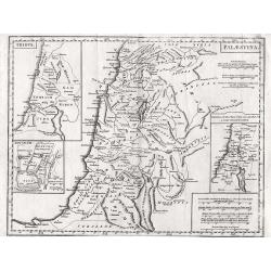
Palaestina.
Highly detailed map of the Holy Land with insert of Tribus and Jerusalem and distance scale.
Date: London, 1795
Selling price: ????
Please login to see price!
Sold in 2012
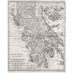
Graeciae Antiquae.
Graeciae Antiquae 1795 by Samuel John Neele. Published May 10th 1795 by Cadell & Davies of the Strand London.Highly detailed small map.
Date: London, 1795
Selling price: ????
Please login to see price!
Sold in 2012
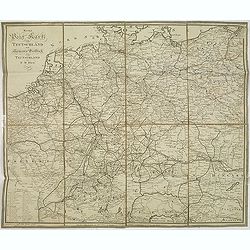
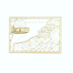
Neue post karte von teutschland.
Uncommon post road maps and commercial roads of Germany, the Low Countries, Poland, Switzerland, Austria and Northern Italy, published by the well-known map makers and ma...
Date: Frankfurt am Main, 1795
Selling price: ????
Please login to see price!
Sold in 2013
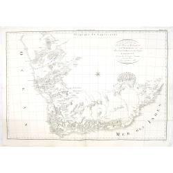
Carte de la Partie Méridionale de l'Afrique, pour servir d'intelligence aux deux voyages de Le Vaillant.
This map depict François Le Vaillant's (1753-1824) two journeys into the interior of Africa, during the years 1783, 1784 and 1785. The route through Namaqualand and alon...
Date: H. J. Jansen et Comp., Paris, 1795
Selling price: ????
Please login to see price!
Sold in 2013
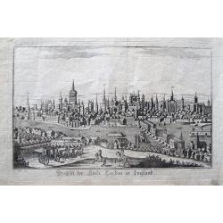
Prospect der Stadt London in England.
Rarely seen view of London from across the Thames. With many detailed buildings, including the London Bridge. A horse carriage and horsemen in the foreground. By Somnmer ...
Date: Vienna, c1795
Selling price: ????
Please login to see price!
Sold in 2013

Homme Masque de l'Isle de Sandwich
From a French edition of Captain Cook's voyages.
Date: Paris, ca. 1795
Selling price: ????
Please login to see price!
Sold in 2020
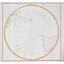
Carte de l' Hemisphere Austral.
Captain James Cook (1728-79), explorer, circumnavigator and hydrographer. Three voyages, 1768-71, 1772-75 and 1776-79. From 1778 on printed editions of ' Captain Cook's T...
Date: Paris, c. 1795
Selling price: ????
Please login to see price!
Sold in 2016
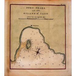
Port Praija aan het Eiland St. Jago.
Map of Porto Praya at the southern part of St. Jago Island, one of the Cape Verde Islands.
Date: The Hague, 1795
Selling price: ????
Please login to see price!
Sold in 2014
Vorstellung der zwischen der Wolga und dem Ural-Fluss gelegnen Wüsten, Steppe und der benachbarten Gegenden
Rare and detailed map of European Russia between the Volga and Ural rivers. From "Allgemeine Geschichte der neuesten Entdeckungen ... in vielen Gegenden des russisch...
Date: Bern, der typographischen Gesellschaft, 1777 or 1795
Selling price: ????
Please login to see price!
Sold in 2014
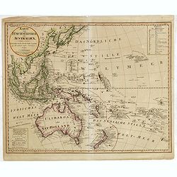
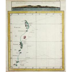
Karte vom Funften Erdtheil oder Polynaesien ..Australien..
Prepared by Friedrich Canzler. Australia called Ulimaroa , often used at that time as it was the term Cook learned from the New Zealand Maoris. Including Indonesia, Taiwa...
Date: Nuremberg, 1795
Selling price: ????
Please login to see price!
Sold in 2015
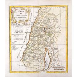
Judee ou Terre Sainte.
Copper engraved, hand-colored map of present day Istael and Jorden. It shows the 12 tibes, the six provinces under Herod and the 3 Roman provinces. The map was engraved b...
Date: Paris, 1795
Selling price: ????
Please login to see price!
Sold in 2017
Planches de l'origine de tous les cultes, du citoyen dupuis, avec leur explication.
Original edition. Atlas volume of the four volume work "Origine de tous les cultes" with a fine engraved title page after Ducoudray and engraved by Pauquet.Illu...
Date: Paris, Agasse, An III, 1795
Selling price: ????
Please login to see price!
Sold in 2015
Chart of the Sandwich Islands.
Scarce map of the Hawaiian Islands featuring the large island of Owhyhee, Mowee [Maui], Tahroorowa, and Ranai. Shows the time-dated sea-track of James Cook from November ...
Date: London, ca. 1795
Selling price: ????
Please login to see price!
Sold in 2015
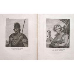
Pair of 2 prints: Winée, naturelle D'Owhyée; Tianna, Prince d'Atooi.
Two great portraits of native Hawaiians by John Meares. From Collection de Cartes Geographiques, Vues, Marines, Plans et Portraits, relatifs aux Voyages du Capitaine J. M...
Date: Paris, 1795
Selling price: ????
Please login to see price!
Sold in 2022
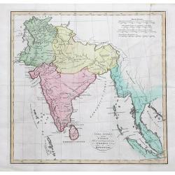
India Antiqua, auctore D'Anville...
Large scale map of India and Siam, extending to the Strait of Malacca and the area of today's Singapore. With several place names, rivers, islands, and mountain ranges sh...
Date: London, c1795
Selling price: ????
Please login to see price!
Sold in 2016
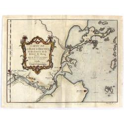
Carte de la Baye d'Hocsieu et des Entres de la Riviere de Chang Situees dans la Province de Fokyen.
Detailed regional map of China. A detailed little chart of the estuary of the Chiang River at present-day Fu-chou in the province of Fukien, adjacent to the island of Ta...
Date: Amsterdam, 1795
Selling price: ????
Please login to see price!
Sold in 2016
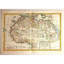
Barbarie, Egypte, Nigrite, Guinee, Nubie, Abissinie
Fine map of North Africa and Arabian Peninsula. Engraved by E. Dussy. Gilles Robert de Vaugondy (1688–1766), also known as Le Sieur or Monsieur Robert, and his son, Did...
Date: Paris, 1795
Selling price: ????
Please login to see price!
Sold in 2016
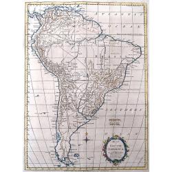
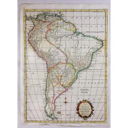
Map of South America.
Interesting map of South America. Features large blank areas inside Brazil and Argentina, but also a lot of details and place names along the coasts and rivers. Names als...
Date: London, 1795
Selling price: ????
Please login to see price!
Sold in 2016
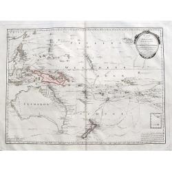
Karte von der Inselwelt Polynesien oder dem Fünften Welttheile...
A fantastic map of the Pacific Ocean, from Kanton (China), the Philippines until Hawaii, and from Australia and New Zealand to the Marquesas Islands. Filled with routes o...
Date: Vienna, ca 1795
Selling price: ????
Please login to see price!
Sold in 2017
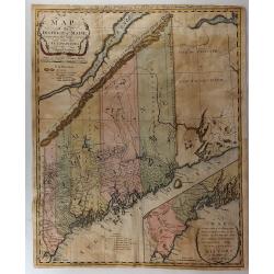
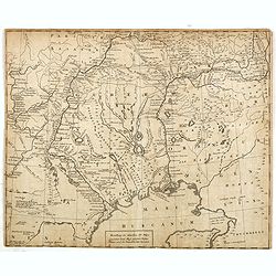
A Map of the District of Maine, Drawn from the Latest Surveys and Other Best Authorities.
A very lovely and important map. One of the first printed maps of Maine - At that time Maine was part of Massachusetts. The map was the frontispiece from James Sullivan�...
Date: Boston. 1795
Selling price: ????
Please login to see price!
Sold in 2017
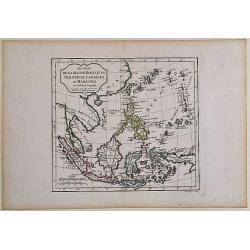
Les Isles de la Sonde, Moluques, Philippines, Carolines et Marianes Par Robert de Vaugondy.
From the atlas Nouvel Atlas Portatif destiné principalement à la jeunesse d'après la Géographie Moderne de l'Abbé Delacroix, published by Felix Delamarche, in Paris....
Date: Paris, 1795
Selling price: ????
Please login to see price!
Sold in 2017
Map of South America.
A map of South America for the Rev. Dr. Robertson's “History of America” by Thos. Kitchin, 'Hydrographer to his Majesty'. It features a decorative floral title cartou...
Date: London, 1795
Selling price: ????
Please login to see price!
Sold in 2020
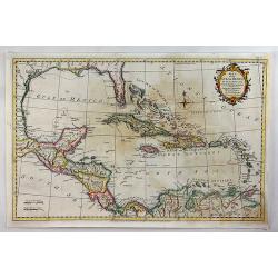
Map of the Gulf of Mexico, the Islands and Countries Adjacent.
A striking map of the West Indies, Gulf Coast, Florida, etc. Published in the Rev. Dr. Robertson's “History of America”. Includes a compass rose and decorative title ...
Date: London, 1795
Selling price: ????
Please login to see price!
Sold in 2018
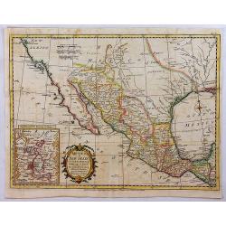
Mexico or New Spain.
One of the most popular maps of Mexico and the Southwest of America during the late 18th century. The map reflects the contemporary commercial cartography of 1777, the da...
Date: London, 1795
Selling price: ????
Please login to see price!
Sold in 2018
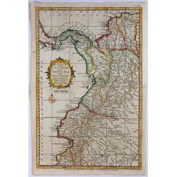
Map of the Countries of the South Sea from Panama to Guayquil.
A striking map of Central America, including Columbia, Ecuador, Panama, the New Kingdom of Granada and Quito. From Dr. Robertson's 'History of America'.Thomas Kitchin (17...
Date: London, 1795
Selling price: ????
Please login to see price!
Sold in 2018

Atlas Universel Par ROBERT Geographe et par Robert de Vaugondy. . .
A copper engraved title page origin: de Vaugondy's Atlas Universal. Signed by the engraver Jean Charles Baquoy at lower right. A very elaborate title page with the person...
Date: Paris, 1795
Selling price: ????
Please login to see price!
Sold in 2018
Afrique divisee en ses principaux Empires et Royaumes.
An attractive map of the continent of Africa was published at the end of the eighteenth century in Paris and published by Robert de Vaugondy. This map was first published...
Date: Paris, 1795
Selling price: ????
Please login to see price!
Sold in 2018
A Map of the Discoveries made by Capt. Cook & Clerke in the Years 1778 & 1779 between the Eastern Coast of Asia and the Western Coast of North America. . .
An early American map showing Cook's explorations of Hawaii and Alaska, published in one of the first atlas of America printed in America. "Engraved for Cary's Ameri...
Date: Philadelphia, 1795
Selling price: ????
Please login to see price!
Sold in 2019
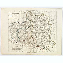
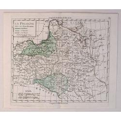
La Pologne avec ses demenbremens.
An interesting map of Poland with her borders at 1795, with original color showing the Prussian, Austrian and Russian parts. Mileage scales and explanation box. Map from ...
Date: Paris, 1795
Selling price: ????
Please login to see price!
Sold in 2020
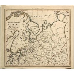
Northern Part of Russia in Europe.
Interesting antique map of the northern part of western Russia including Saint Petersburg, Novogorod, Russian Lapland, and the area stretching to the Gulf of Kara and the...
Date: London, 1795
Selling price: ????
Please login to see price!
Sold in 2019
Das Departement des Canals La Manche.
Manche is one of the original 83 departments created during the French Revolution on March 4, 1790. It was created from part of the province of Normandie. The first capit...
Date: Vienna, ca 1795
Selling price: ????
Please login to see price!
Sold in 2021
![[18th century toll road share with signature of the first Dollar millionaire.]](/uploads/cache/83497-250x250.jpg)
[18th century toll road share with signature of the first Dollar millionaire.]
Important toll road share published in Philadelphia, 16 March 1795, 1 Share, #674, issued to Henry Pratt. Vignette of an early toll road, toll house, gate and vans in top...
Date: Philadelphia, 1795
Selling price: ????
Please login to see price!
Sold in 2019
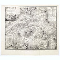
Carte pétrographique du St. Gothard : cette portion de la chaine centrale des Alpes comprend les Monts St. Gothard. . .
Rare detailed Petrographic map of St. Gothard, showing the central chain of the Alps including the St. Gothard and Fourche mountains, the sources of the Rhône, the Rhin,...
Date: Mechem, 1795
Selling price: ????
Please login to see price!
Sold in 2021
![Carte de l'ancien royaume de Pologne partage entre la Russie la Prusse et l'Autriche. . . [two sheet map]](/uploads/cache/45093-250x250.jpg)
Carte de l'ancien royaume de Pologne partage entre la Russie la Prusse et l'Autriche. . . [two sheet map]
Detailed map of Poland prepared by Pierre-Gilles Chanlaire (1758-1817). According to the tile the map is showing the old Kingdom of Poland, divided between the Russian, P...
Date: Paris, 1795
Selling price: ????
Please login to see price!
Sold in 2022
Carta Generale de Paesi Bassi Terzo Foglio. . .
This is one sheet of a six sheet map on the Low Countries, each with its own decorative cartouche and separate borders. This map encompasses the northwestern portion of B...
Date: Rome, 1795
Selling price: ????
Please login to see price!
Sold in 2020
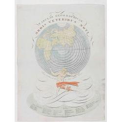
Tabulae Geographicae Orbis Veteribus noti.
Rare title page of an atlas with Atlas carrying the world. Copper engraving by Franz Reißer published in: "Tabulae Geographicae Orbis Veteribus noti". Title en...
Date: Vienna, ca. 1795
Selling price: ????
Please login to see price!
Sold in 2020
La Pologne avec ses Demenbremens.
A fine map of Poland and Lithuania by Delamarche in 1795. He has the Baltic Sea to the north and Hungary to the south.Charles Francois Delamarche (1740-1817) founded the ...
Date: Paris, 1795
Selling price: ????
Please login to see price!
Sold in 2020
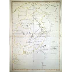
A Chart, on Mercator's Projection, Containing the Track and Soundings of the Lion, the Hindostan and Tenders, from Turon-Bay in Cochin-China. . .
A chart engraved by Baker and published by Nichol, this large chart traces the routes of the Lion, Hindostan, and Tenders with considerable detail. The chart was part of...
Date: London, 1796
Selling price: ????
Please login to see price!
Sold in 2020
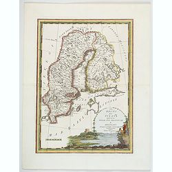
Il Regno di Svezia divisio nelle sue provincie e delineato. . .
This delightful map of Sweden and Finland highlights rivers, lakes, mountains and towns. The decorative title cartouche depicts a man fishing with small ships sailing in ...
Date: Rome, 1796
Selling price: ????
Please login to see price!
Sold in 2020