Browse Listings
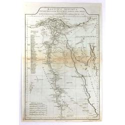
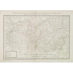
Aegyptus Antiqua Mandato Serenissimi Delphini Publici Juris Facta.
A large detailed map of Ancient Egypt, covering from the Nile Delta and Gaza, southward as far as Aswan. Features both ancient and contemporary place names for each desti...
Date: London, 1794
Selling price: ????
Please login to see price!
Sold in 2016
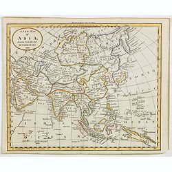
A New Map of Asia, Drawn from the best Authorities 1791.
Attractive map of Asia from "The General Gazetteer or Compendious Geographical Dictionary" by R. Brookes.The map is of interest for the use of Sea of Korea, for...
Date: London, 1794
Selling price: ????
Please login to see price!
Sold in 2015
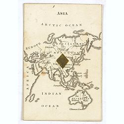
ASIA. (with Australia - Cartographic playing card)
A very rare cartographic playing card (sold as a single, individual card only) featuring an engraved map of Asia and Australia, being the ‘1 of Diamonds’, with one Di...
Date: London, 1794
Selling price: ????
Please login to see price!
Sold in 2015
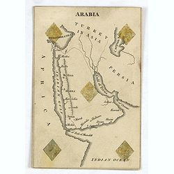
ARABIA ( Cartographic playing card)
A very rare cartographic playing card (sold as a single, individual card only) featuring an engraved map of Arabia, being the ‘5 of Diamonds’, with five Diamonds sten...
Date: London, 1794
Selling price: ????
Please login to see price!
Sold in 2016
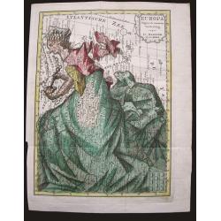
Europa volgens de nieuwste verdeeling.
Uncommon curiosity, depicting Europe as a regal queen but with an interesting twist and political commentary. This anti-Napoleonic image demotes Europa from a virgin-quee...
Date: Haarlem, 1794
Selling price: ????
Please login to see price!
Sold in 2015
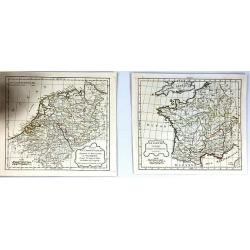
(2 Maps) La Gaule & Partie de L'Empire Francais Royaumes de Hollande, de Westphalie, grand duche de Berg
Two maps of France at different times during their history. They are by Delamarche, the successor of Robert de Vaugondy.
Date: Paris, 1794
Selling price: ????
Please login to see price!
Sold in 2017
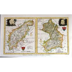
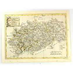
A New Map of Northhamptonshire & Cambridgeshire Drawn from the latest Authorities (Two maps on one page)
Two attached charming and detailed 18th Century county maps engraved by Thomas Condor for “The New And Complete English Traveller” in London. Published by Alexander H...
Date: London, 1794
Selling price: ????
Please login to see price!
Sold in 2016
Royaume de Pologne. Par Robert de Vaugondy
Map of Poland and Lithuania by C. F. Delamarche, successor of Robert de Vaugondy, Geographer. With a color key to Russian, Prussian and Austrian possessions.C.F. Delamarc...
Date: Paris, 1794
Selling price: ????
Please login to see price!
Sold in 2015
Partie Septenttrionale de la Russie Europeenne par Robert de Vaugondy
Map of European Russia by C. F. Delamarche, successor of Robert de Vaugondy, Geographer. With a color key to Russian, Prussian and Austrian possessions.C.F. Delamarche wa...
Date: Paris, 1794
Selling price: ????
Please login to see price!
Sold in 2019
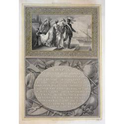
Richard I Leaving Cyprus
A beautifully engraved scene, Richard the 'Lion Heart' is about to board his ship leaving Cyprus in preparation for the Crusade. From Robert Bowyer's edition of Hume's 'H...
Date: London, 1794
Selling price: ????
Please login to see price!
Sold in 2015
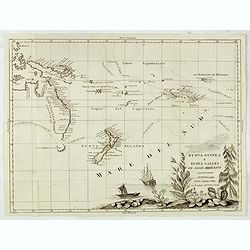
Nuova Guinea e Nuova Galles ed Isole Adjacenti
Map of the South Pacific, showing the sailing routes to the South Pacific by Carteret and Byron, but most importantly, the discoveries made by Captain Cook, 1768-1771. Th...
Date: Venise, 1794
Selling price: ????
Please login to see price!
Sold in 2015
A New and Accurate Map of France, divided into Departments, Districts....
A fine map of France from Spencer's 'History of England'. The title cartouche features the French flag and a military helmet.There is an insert of the Island of Corsica.
Date: London, 1794
Selling price: ????
Please login to see price!
Sold in 2016
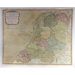
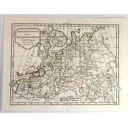
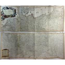
Seat of War in the Seven United Provinces, Comprehending Holland, Zeeland, Utrecht, Gelders, Over-Yssel, Frieseland and Groningen; with the Land of Drant; also Dutch Flanders and Dutch Brabant
An extraordinary 1794 map of the Netherlands, or Holland, by Laurie and Whittle. It features the entire region in extraordinary detail, offering both topographical and po...
Date: London, 1794
Selling price: ????
Please login to see price!
Sold in 2018
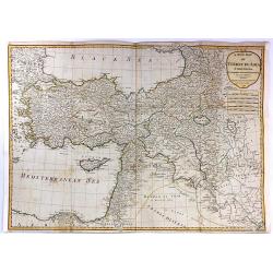
A New Map of Turkey in Asia...
A stunning large format, double page map of Turkey in Asia from Anatolia in the west to Persia in the east, by the French cartographer and geographer J. B. d'Anville. Th...
Date: Paris, 1794
Selling price: ????
Please login to see price!
Sold in 2016
Parte Meridionale del Circolo Dell' Alta Sassonia ....
The Southern Part of the Circle of Upper Saxony with Lusatia etc. The map comes from the rare geographical atlas that was published in Siena by Pazzini Carli between 1798...
Date: Siena, 1794
Selling price: ????
Please login to see price!
Sold in 2016
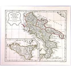
Royaume de Naples et de Sicile ...
The Kingdom of Naples is the southernmost portion of the Italian peninsular. The map features include a decorative title cartouche and an inset map of Sicily. Each separa...
Date: Paris, 1794
Selling price: ????
Please login to see price!
Sold in 2016
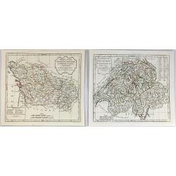
(2 Maps) La Republique Helvetique & Poitou, Aunis, Saintonge et Angoumous. La Marche, Limosen et Auvergne.
Two detailed maps by Delamarche, a worthy successor to R. de Vaugondy. ~One map is of Switzerland, and the other is of several provinces of France.
Date: Paris, 1794
Selling price: ????
Please login to see price!
Sold in 2016
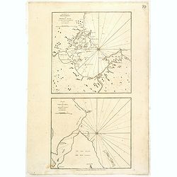
The Bay of Tricoenmale or Trinkili-Male, on the East Coast of Ceylon. (together with) Plan of Venlos Bay, on the East Coast of Ceylon.
Nautical chart of the Tricoenmale or Trinkili-Male (Trincomalee) Bay and the Venlos (Vandelous) Bay on the east coast of Sri Lanka or Ceylon.Two charts on a single sheet,...
Date: London, 1794
Selling price: ????
Please login to see price!
Sold in 2016
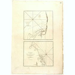
Calpentyn Road, on the West Coast of Ceylon. The East Coast of Ceylon, from Venlos Bay to Batecalo, with the Banks, Rocks, Soundings & ca.
Two nautical charts on one sheets, originally prepared by the Dutch publisher Van Keulen. The upper chart of Calpentyn Road, on the West Coast of Ceylon. (255x257mm.)The ...
Date: London, 1794
Selling price: ????
Please login to see price!
Sold in 2020
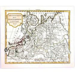
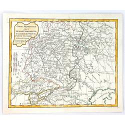
Partie Septentrionale de la Russie Europeenne.
A highly detailed map of the Northwestern part of Russia, from the Gulf of Finland and Poland, to the western part of Asian Russia, by Charles Francois Delamarche, the su...
Date: Paris, 1794
Selling price: ????
Please login to see price!
Sold in 2016
Partie Meridionale de la Russie Europeenne, tartarie Russienne, Petit Tartatie.
A highly detailed map of middle Russia, from Poland to Siberia, by Charles Francois Delamarche, the successor to Robert de Vaugondy.Charles François Delamarche, (1740–...
Date: Paris, 1794
Selling price: ????
Please login to see price!
Sold in 2016
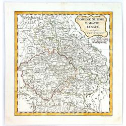
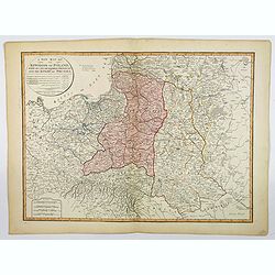
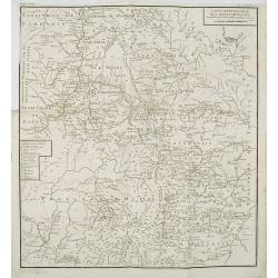
Boheme, Silesie, Moravie, Lucace.
A highly detailed map of Bohemia, Silesia, Moravia and Lusace, by Charles François Delamarche, the successor to Robert de Vaugondy.Charles Francois Delamarche, (1740–1...
Date: Paris, 1794
Selling price: ????
Please login to see price!
Sold in 2016
Map of the Empire of Germany, Including All the States Comprehended Under that Name: With the Kingdom of Prussia, &c.
A huge, striking, two panel wall map of Germany, Austria, Bohemia (Czech Republic), Poland, Lithuania, Prussia, Switzerland, Holland (the Netherlands), Belgium and Denmar...
Date: London, 1794
Selling price: ????
Please login to see price!
Sold in 2016
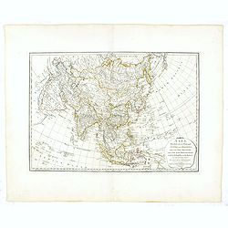
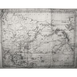
Asia, divided into its principal states and regions, with all the islands and the new discoveries made by the English and the Russians in the eastern parts.
A detailed map of Asia.The map is of interest for the use of Gulf of Corea, for the sea between Korea and Japan.
Date: London, 1794
Selling price: ????
Please login to see price!
Sold in 2016
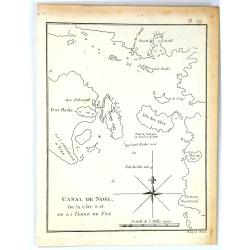
Canal de Noël sur la côte S.O. de la Terre de Feu.
A simple map of Christmas Sound from James Cook’s voyages. Cook reached Christmas Sound near Tierra del Fuego on 25th & 26th December 1774, returning to England on ...
Date: London, 1794
Selling price: ????
Please login to see price!
Sold in 2016
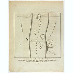
Sketch of the Catawba River at McCowan's Ford. . .
Revolutionary War battle plan, showing Lord Cornwallis' march and crossing of the Catawba River at McCown's Ford (now Cowan's Ford), and on towards Salisbury, along with ...
Date: London, 1794
Selling price: ????
Please login to see price!
Sold in 2018
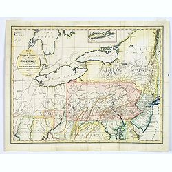
Map of the Middle States of America, comprehends New-York, New-Jersey, Pennsylvania, Delaware, and the Territory N.W. of Ohio.
An interesting map of the region of the United States extending from New Jersey to Indiana, and from northern New York to Maryland. Detail in the east is plentiful, with ...
Date: London, 1794
Selling price: ????
Please login to see price!
Sold in 2017
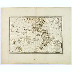
America North and South and the West Indies, with the Atlantic, Aethiopic and Pacific Oceans. . .
A Laurie and Whittle produced map of Samuel Dunn's earlier work of the Americas from A New Atlas of the Mundane System, or of Geography and Cosmography. Of particular int...
Date: London, 1794
Selling price: ????
Please login to see price!
Sold in 2018
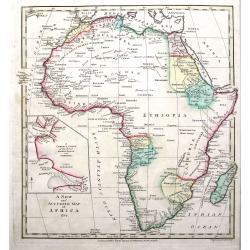
A New and Accurate Map of Africa.
A fine map of the continent with the actual information available at the end of the 18th century. Shows only limited information in the interior but many towns, regions, ...
Date: London, 1794
Selling price: ????
Please login to see price!
Sold in 2018
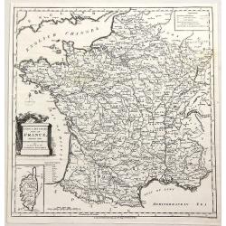
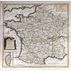
A New & Accurate Map of France, Divided Into Departments, districts & c. as Decreed by the National Assembly.
A highly detailed map of France, published by John Cary, the founder of the famous English cartographic firm. Detail is copious and precisely delineated, including mounta...
Date: London, 1794
Selling price: ????
Please login to see price!
Sold in 2019
Carte de la Mer Pacifique du Nord, contenant la Cote Nord-Est D'Asie et la Cote Nord-Ouest D'Amerique ...1778 et 79 par le Capn Cook, et...1788-89 par le Capne Jean Meares
A marvelous map of the North Pacific, detailing the explorations of the Captain John Meares.This map covers a large portion of the Asian and North American continents, ho...
Date: Paris, 1794
Selling price: ????
Please login to see price!
Sold in 2018
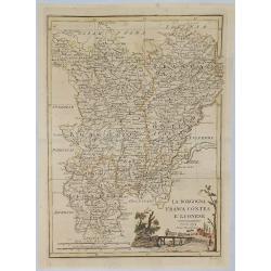
La Borgogna Franca Contea E Lionese.
A pleasant map of the Borgogna, Franca Contea and Lionese regions of France, by Carli Pazzini in Sienna in 1794. The map features a cartouche with a peasant leading cattl...
Date: Siena, 1794
Selling price: ????
Please login to see price!
Sold in 2019
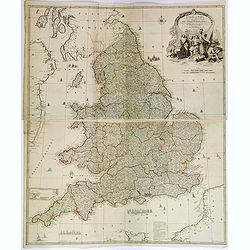
England and Wales drawn from the most accurate Surveys. . .
A delightful, large four sheet map of England and Wales, published in London towards the end of the eighteenth century. This impressive large-scale map was drawn by Rocqu...
Date: London, ca 1794
Selling price: ????
Please login to see price!
Sold in 2018
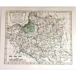
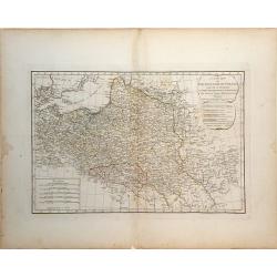
A New Map of the Kingdom of Poland, with its Dismembered Provinces and the Kingdom of Prussia.
This important 1794 map by Thomas Kitchin shows the Kingdom of Poland during the very brief transitional period between the second and third partitions. Map extent is fro...
Date: London, 1794
Selling price: ????
Please login to see price!
Sold in 2019

The Coast of Yucatan from Campeche to Ascension Bay with the West End of Cuba, ...
Double page sea chart showing the Yucatan Peninsula to the lower edge, the western tip of Cuba shown to the right edge. A quartered compass rose shown to lower right corn...
Date: London, Laurie and Whittle. 1794
Selling price: ????
Please login to see price!
Sold in 2020
Die Insel Jura.
A decorative map of Jura Island in western Scotland, from Von Reilly's remarkable atlas published in 1794.Austrian born Franz Johann Joseph von Reilly (1766-1820) produce...
Date: Austria, 1794
Selling price: ????
Please login to see price!
Sold in 2020

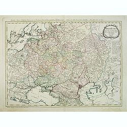
Imperium Russicum, cum regionibus adiacentibus duabus Tabulis ex optima quae A. 1784 tribus foliis comparavit Mappa geographica, aliisque subsidiis delineatum a C. Mannert, Tabula Ima. . .
A detailed map of the European part of the Russian Empire. Scarce map. Copper etching by C. Mannert and edited by Adam Gottlieb Schneider and Johann Christoph Weigel. Man...
Date: Nuremberg, 1794
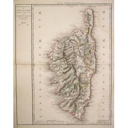
Département de l'Isle de Corse..
Detailed map of Corsica prepared and published by Doudan Dumez in his Atlas de la France.. par une société d'ingénieurs François..
Date: Paris 1794
Selling price: ????
Please login to see price!
Sold
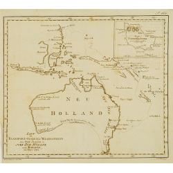
LAUF des Transport-Schiffes Waaksamheyd von Port Jackson..
Fine map of Australia with inset of Norfolk Island. Showing the track from Port Jackson in New South Wales to Batavia, of the vessel Waaksamheyd. Engraved by C.F.Gürsch.
Date: Hamburg 1794
Selling price: ????
Please login to see price!
Sold
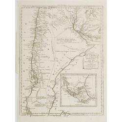
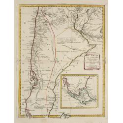
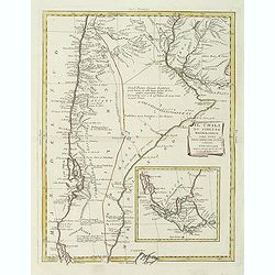
Il Chili lo Stretto Magellanico coll' Isola della Terra del Fuoco.
A finely engraved copper plate map that covers Chili and most of Argentina. Good detail of the region around Buenos Ayres and the Rio de la Plata. Santiago here is named ...
Date: Venise 1794
Selling price: ????
Please login to see price!
Sold
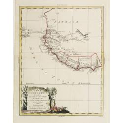
La Guinea Occidentalle..
An engraved chart of the coast from Sierra Leone to Cape delle Tre Punte.
Date: Venise, 1794
Selling price: ????
Please login to see price!
Sold in 2010
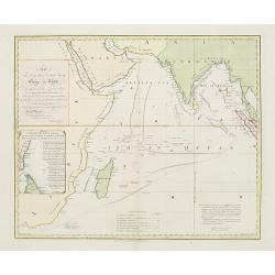
This chart .. tracks of ships in the different monsoons..
Curious over-sized prepared by Benjamin Lacam, showing the Indian Ocean, including Cape of Good Hope, Arabia, India and Malay Peninsula. In the Ocean several tracks are ...
Date: London, 1794
Selling price: ????
Please login to see price!
Sold in 2018
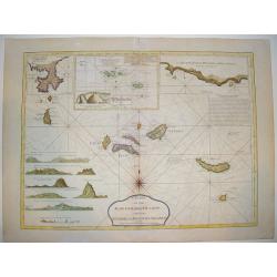
Chart of the Acores (Hawks) Islands, called also the Flemish and Western Islands
This is a fine, handsome nautical chart showing all the Azores islands with currents, rumb lines, anchorages, etc. Relief is shown by hachures, Includes 6 coastal profile...
Date: London, ca. 1794
Selling price: ????
Please login to see price!
Sold
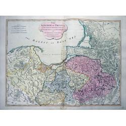
The Kingdom of Prussia...
Large and very detailed map showing parts of today Poland, Kaliningrad Oblast, and Lithuania. Detailed map, includes the cities of Gdansk, Konigsberg (Kaliningrad), Memel...
Date: London, 1794
Selling price: ????
Please login to see price!
Sold in 2012
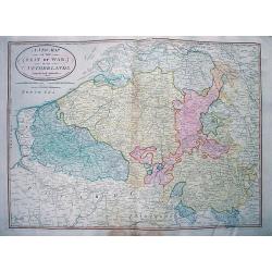
A New Map of the Seat of War in the Netherlands.
Large detailed map of Belgium, including parts of France, Luxembourg, Germany, and the Netherlands. Shows the status of the French Revolutionary Wars in 1794. Important m...
Date: London, 1794
Selling price: ????
Please login to see price!
Sold in 2012
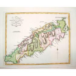
Map of the Island of Tobago for the History of the West Indies by Bryan Edwards Esqr.
A superbly engraved, seldom seen map of the island of Tobago. The work offers nice topographical detail and identifies all the island's land divisions, as well as major t...
Date: London, ca. 1794
Selling price: ????
Please login to see price!
Sold in 2008
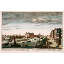
A view of the Admiralty at Amsterdam of the store houses, wharfes.. To the East India Company of Holland. . .
Decorative view of the headquarters of the V.O.C. (present-day Maritieme Museum) and their wharfes and docks, with extensive shipping. After a design by Peter van Rijne.
Date: London, 1794
Selling price: ????
Please login to see price!
Sold in 2022
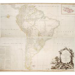
A map of South America containing Terra-Firma.. Brasil.. Patagonia..
A large wall map of south America. Impressive title cartouche lower right and a large text block lower left : "Division of South America with a summary account of it...
Date: London,1794
Selling price: ????
Please login to see price!
Sold in 2013
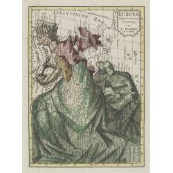
Europa volgens de nieuwste verdeeling.
Uncommon curiosity, depicting Europe as a regal queen but with an interesting twist and political commentary. This anti-Napoleonic image demotes Europa from a virgin-quee...
Date: Haarlem, 1794
Selling price: ????
Please login to see price!
Sold in 2009
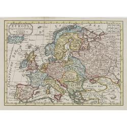
Europa volgens de nieuwste verdeeling.
Uncommon map of Europe with Dutch title and text.Published in "Boertige reis door Europa", by A.Fokke.Printed by Francois Bohn in Haarlem, who was active from 1...
Date: Haarlem, 1794
Selling price: ????
Please login to see price!
Sold in 2009
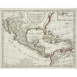
Nouvelle Espagne, Nouvaeu Mexique, Isles Antiles.
Published by Charles Lamarche. Showing the most notable areas of New Spain in North, South and Central America from Nouveau Mexique to Terre Ferme as well as the Caribbea...
Date: Paris, 1794
Selling price: ????
Please login to see price!
Sold in 2011
Il Chili lo Stretto Magellanico coll' Isola della Terra del Fuoco.
A finely engraved copper plate map that covers Chili and most of Argentina. Good detail of the region around Buenos Ayres and the Rio de la Plata. Santiago here is named ...
Date: Venise, 1794
Selling price: ????
Please login to see price!
Sold in 2009
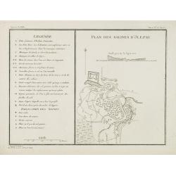
Plan des salines d'Jlezki.
Map from a second French edition of Peter Simon Pallas' Voyages du Professeur Pallas, dans Plusieurs Provinces de l'Empire de Russie et dans l'Asie Septentrionale, engrav...
Date: Paris, Maradan, 1794
Selling price: ????
Please login to see price!
Sold in 2010
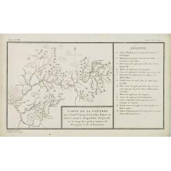
Carte de la contrée qui s'étend le long de la Soka. . .rivieres de Sourgout et de Schoumbout.
Map from a second French edition of Peter Simon Pallas' Voyages du Professeur Pallas, dans Plusieurs Provinces de l'Empire de Russie et dans l'Asie Septentrionale, engrav...
Date: Paris, Maradan, 1794
Selling price: ????
Please login to see price!
Sold in 2010
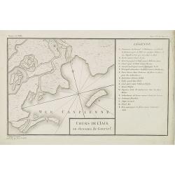
Cours de l'Iaik au dessous de Gourief.
Engraved map of the estuary of the river Ural south of Gurjev. Map from a second French edition of Peter Simon Pallas' Voyages du Professeur Pallas, dans Plusieurs Provin...
Date: Paris, Maradan, 1794
Selling price: ????
Please login to see price!
Sold in 2010
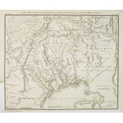
Carte des Landes situées entre le Volga et l'Oural, et des contrées voisines.
Map of the north of the Caspian sea, including Astrakhan, Orenburg, etc. Map from a second French edition of Peter Simon Pallas' Voyages du Professeur Pallas, dans Plusie...
Date: Paris, Maradan, 1794
Selling price: ????
Please login to see price!
Sold in 2010
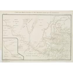
Carte des Monts Altaisk et des deserts salins qui avoisinent.
Map of the Altai Mountains in Central Russia, from a second French edition of Peter Simon Pallas' Voyages du Professeur Pallas, dans Plusieurs Provinces de l'Empire de Ru...
Date: Paris, Maradan, 1794
Selling price: ????
Please login to see price!
Sold in 2010
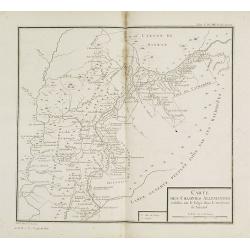
Carte des colonies Allemandes établies sur le Volga dans le territoire de Saratof.
Map of south west of Russia around Saratof. Map from a second French edition of Peter Simon Pallas' Voyages du Professeur Pallas, dans Plusieurs Provinces de l'Empire de ...
Date: Paris, Maradan, 1794
Selling price: ????
Please login to see price!
Sold in 2010
Carte d'une partie des gouvernemens de Tobolsk et d'Irkoutsk. . .
Map of the region around Lake Baikal. Map from a second French edition of Peter Simon Pallas' Voyages du Professeur Pallas, dans Plusieurs Provinces de l'Empire de Russie...
Date: Paris, Maradan, 1794
Selling price: ????
Please login to see price!
Sold in 2010
Carte mineralogique des Monts Ouralsks depuis la source de la Bielaia jusqu'à la Sosva.
Map from a second French edition of Peter Simon Pallas' Voyages du Professeur Pallas, dans Plusieurs Provinces de l'Empire de Russie et dans l'Asie Septentrionale, engrav...
Date: Paris, Maradan, 1794
Selling price: ????
Please login to see price!
Sold in 2010
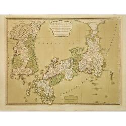
The Empire of Japan divided into seven principal parts and subdivided into sixty-six kingdoms, with the Kingdom of Corea, from Kempfer and the Portuguese.
Detailed map of Japan and Korea prepared by Kaempfer and published in London by Laurie and Whittle, from "New Universal Atlas".The map is of interest for the us...
Date: London, 1794
Selling price: ????
Please login to see price!
Sold in 2010
A New Map of the Kingdom of Poland with all its Divisions and The Dismember'd Provinces by Samuel Dunn, Mathematician
A finely detailed map of the "Kingdom of Poland" by created by Samuel Dunn and published by the Laurie and Whittle firm of London. The map includes the regions ...
Date: London, 1794
Selling price: ????
Please login to see price!
Sold in 2010

10 engravings of architecture prints : Ancien batiment à Bolgari, et Monnoies. . .
10 Engravings of buildings and structures in Russia from a second French edition of Peter Simon Pallas' Voyages du Professeur Pallas, dans Plusieurs Provinces de l’Empi...
Date: Paris, Maradan, 1794
Selling price: ????
Please login to see price!
Sold in 2010
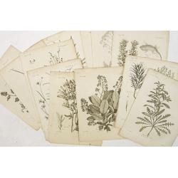
12 engravings of botanical prints : pyrus salicifolia. . .
12 Engravings from a second French edition of Peter Simon Pallas' Voyages du Professeur Pallas, dans Plusieurs Provinces de l’Empire de Russie et dans l’Asie Septentr...
Date: Paris, Maradan, 1794
Selling price: ????
Please login to see price!
Sold in 2019

12 engravings of botanical prints: Hedisarum grandiflorum. . .
12 Botanical engravings from the second French edition of Peter Simon Pallas' Voyages du Professeur Pallas, dans Plusieurs Provinces de l’Empire de Russie et dans l’A...
Date: Paris, Maradan, 1794
Selling price: ????
Please login to see price!
Sold in 2018
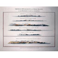
Several Appearances of Hogs Island on the Western Coast of Sumatra.
RARE sheet from "The country East-India Pilot" published in 1799 by Laurie & Whittle. Interesting copper engraved sheet with five views of Hogs Island and ...
Date: London, 1794
Selling price: ????
Please login to see price!
Sold in 2011
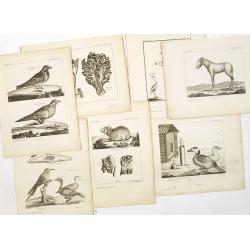
7 animals engravings prints : Alauda tatarica. . .,cheval sauvage, piège pour les oiseaux, lepus alpinus. . .,grue blanche. . .,fringilla calcarata, fourneau pour la préparation des cuirs. . .,
7 engravings from a second French edition of Peter Simon Pallas' Voyages du Professeur Pallas, dans Plusieurs Provinces de l’Empire de Russie et dans l’Asie Septentri...
Date: Paris, Maradan, 1794
Selling price: ????
Please login to see price!
Sold in 2015
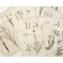
10 engraving of botanical prints : astragalus melilotoides. . .
10 Engravings from a second French edition of Peter Simon Pallas' Voyages du Professeur Pallas, dans Plusieurs Provinces de l’Empire de Russie et dans l’Asie Septentr...
Date: Paris, Maradan, 1794
Selling price: ????
Please login to see price!
Sold in 2015

9 engravings of botanical prints: Cucubalus fruticosus. . .
9 Engravings from a second French edition of Peter Simon Pallas' Voyages du Professeur Pallas, dans Plusieurs Provinces de l’Empire de Russie et dans l’Asie Septentri...
Date: Paris, Maradan, 1794
Selling price: ????
Please login to see price!
Sold in 2022
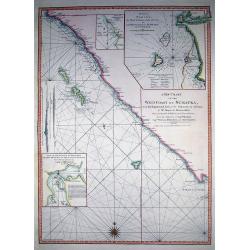
A New Chart of the West Coast of Sumatra,...
SCARCE nautical from "The country East-India Pilot" published in 1799 by Laurie & Whittle. Great copper engraved map of Western Sumatra and Nassau or Pogg...
Date: London, 1794
Selling price: ????
Please login to see price!
Sold in 2011
Sketch of the Straits of Gaspar...
SCARCE nautical after J. Huddart 1788, published in "The country East-India Pilot" in 1799 by Laurie & Whittle. Great copper engraved map the Strait of Ga...
Date: London, 1794
Selling price: ????
Please login to see price!
Sold in 2011
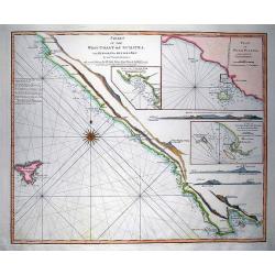
Chart of the West Coast of Sumatra, from Bencoolen to Key Sers Bay.
RARE nautical from "The country East-India Pilot" published in 1799 by Laurie & Whittle. Superb copper engraved map Western Sumatra with Isle Engano or De...
Date: London, 1794
Selling price: ????
Please login to see price!
Sold in 2011
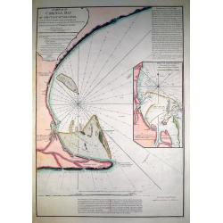
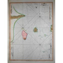
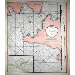
A Sketch of Coringa Bay...
RARE nautical from "The country East-India Pilot" published in 1799 by Laurie & Whittle. Engraved by Neele, after Capt. Lesley 1774. Great copper engraved...
Date: London, 1794
Selling price: ????
Please login to see price!
Sold in 2011
A Chart of the Straits of Sunda, from Point Winerow to North Island...
SCARCE nautical from "The country East-India Pilot" published in 1799 by Laurie & Whittle. After D'Apres de Mannevillette's map from his Neptune Oriental. ...
Date: London, 1794
Selling price: ????
Please login to see price!
Sold in 2011
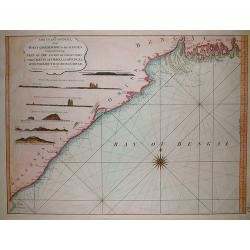
The coast of India, from Point Gordeware to the Ganges comprehending part of the coast of Golconda the coasts of Orissa and Bengal, with the mouth of the Hoogly river
SCARCE sea from "The country East-India Pilot" published in 1799 by Laurie & Whittle. The copper engraved map extends from the Coringa Bay to the Ganges r...
Date: London, 1794
Selling price: ????
Please login to see price!
Sold in 2011
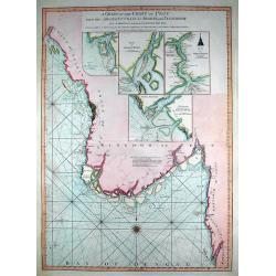
A Chart of the Coast of Pegu with the Adjacent Coast of Arakan and Tanasserim...
SCARCE from "The country East-India Pilot" published in 1799 by Laurie & Whittle. Very large copper engraved map of the area of Pego (nowadays Bago) in Bur...
Date: London, 1794
Selling price: ????
Please login to see price!
Sold in 2011
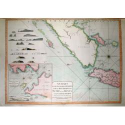
A Chart of the South Part of Sumatra and of the Straits of Sunda and Banca with Gaspar Straits...
SCARCE nautical from "The country East-India Pilot" published in 1799 by Laurie & Whittle. Large copper engraved map displaying parts of Sumatra and Java. ...
Date: London, 1794
Selling price: ????
Please login to see price!
Sold in 2011
Il Chili lo Stretto Magellanico coll' Isola della Terra del Fuoco.
A finely engraved copper plate map that covers Chili and most of Argentina. Good detail of the region around Buenos Ayres and the Rio de la Plata. Santiago here is named ...
Date: Venise, 1794
Selling price: ????
Please login to see price!
Sold in 2011
Imperium Russicum, cum regionibus adiacentibus duabus Tabulis ex optima quae A. 1784 tribus foliis comparavit Mappa geographica, aliisque subsidiis delineatum a C. Mannert, Tabula Ima. . .
A detailed map of the European part of the Russian Empire. Very rare map. Copper etching by C. Mannert and edited by Adam Gottlieb Schneider and Johann Christoph Weigel. ...
Date: Nuremberg, 1794
Selling price: ????
Please login to see price!
Sold in 2011
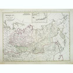
Imperii Russici Pars Orientem Spectans Tab. II da. ex optimis subsidiis delineata a. C. Mannert Norimberge Prostat in Officina A. G. Schneideriana. . .
The Russian empire eastward from the Dvina River, indicating some still unexplored coastlines in Nova Zemlya and northeastern Siberia. Includes an inset with a portion of...
Date: Nurnburg, 1794
Selling price: ????
Please login to see price!
Sold in 2011