Browse Listings
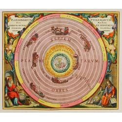
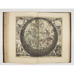
Planisphaerium Ptolemaicum, sive Machina..
This celestial chart shows Ptolemy's theory of celestial system. Circling around the earth are shown the sun, the moon and the five planets then known, impersonalized by ...
Date: Amsterdam 1708
Selling price: ????
Please login to see price!
Sold
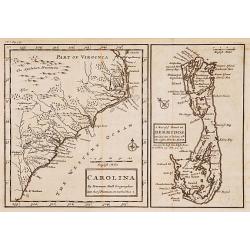
Carolina. / A map of.. Bermudos.
Two maps on one folding sheet. To the left a map of the Carolinas and to the right a map of Bermuda.This map by Herman Moll was published in the first edition of John Old...
Date: London 1708
Selling price: ????
Please login to see price!
Sold
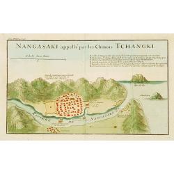
Nangasaki appellé par les Chinois Tchangki.
Attractive bird's-eye view of Nagasaki by Jean de Fontaney from a French collection of Jesuit letters, volume 17. With reference key to principal points of interest. (A-H...
Date: Paris 1708
Selling price: ????
Please login to see price!
Sold
![[Titlepage] Harmonia Macrocosmica seu atlas..](/uploads/cache/06828-250x250.jpg)
[Titlepage] Harmonia Macrocosmica seu atlas..
Title page of the re-issue of this famous celestial atlas prepared by Cellarius. Letterpress with wood block print. Together with second page Index Tabularum listing the ...
Date: Amsterdam 1708
Selling price: ????
Please login to see price!
Sold
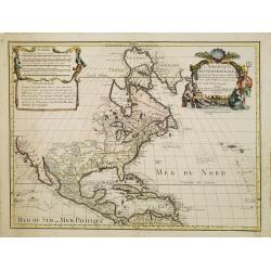
L'Amerique Septentrionale.
Uncommon issue of this decorative map of North America, covering Central America, showing east coast, California, Canada, Caribbean and northern part of South America. Sh...
Date: Amsterdam / Paris 1708
Selling price: ????
Please login to see price!
Sold
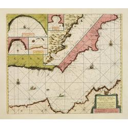
Pascaart van de Zee Kusten van Granada en Murcia.. Barbarische Zee-Kusten..
This sea chart covers the Spanish coast from Véléz-Malaga, in the region Andalucía, from Malaga as far as Alicante and Bay of Altea, in the province of Valencia. It sh...
Date: Amsterdam, 1708
Selling price: ????
Please login to see price!
Sold
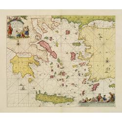
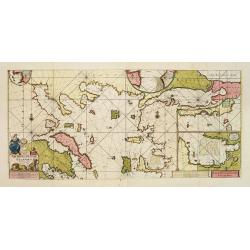
Pascaerte Vande Archipel en de Eylanden.. Candia.. Natolia..
This sea chart covers the Mediterranean coast between the Peloponnese, in Greece, and the Turkish coast facing Rhodes.It is centred in the Aegean Islands and shows Crete ...
Date: Amsterdam, 1708
Selling price: ????
Please login to see price!
Sold
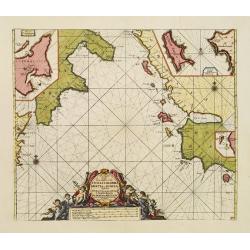
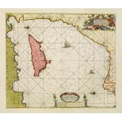
Pas kaart Vande Zee-kusten van Cicilia, Calabria, Graetia en Morea. . .
This sea chart covers the Mediterranean coast between the coast near Syracuse, in Sicily, and the Kythera island (also known as Cerigo), in Greece.It is centred in the Io...
Date: Amsterdam, 1708
Selling price: ????
Please login to see price!
Sold in 2020
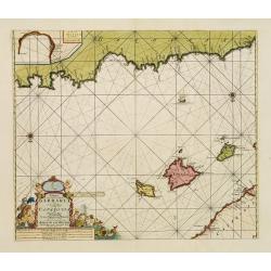
Paskaart, Voor een Gedeelte der Kust van, Barbaria.. Catalonia.. Yvica, Majorca, en Minorca..
This sea chart covers the Algerian coast in front of the Balearic Islands, South on top. Shows the 4 Balearic Islands (Majorca, Minorca, Ibiza) and part of the Catalonian...
Date: Amsterdam, 1708
Selling price: ????
Please login to see price!
Sold
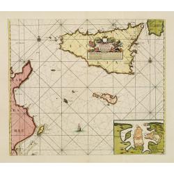
Nieuwe Paskaart van de Zeekusten van 't Eylandt Sicilia..
This sea chart covers the area of the Mediterranean Sea between Italy and the Tunisian coast. Including the islands of Sicily and Malta in the center of the chart. fIt co...
Date: Amsterdam, 1708
Selling price: ????
Please login to see price!
Sold
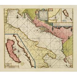
Pascaart vande Weder zytsche Zee-kusten soo van Italia als Dalmatia..
Centred off the Gargano cape, this sea chart covers the coast surrounding the Adriatic Sea between Italy and the first Greek Islands. It contains an 3 enlarged inset plan...
Date: Amsterdam, 1708
Selling price: ????
Please login to see price!
Sold
Paskaart Van de Archipelagusche Eylanden..
This sea chart represents the Northern Aegean Islands. It contains an enlarged inset map of the eastern coast of the Chios island as well as one of the gulf of Smyrna, in...
Date: Amsterdam, 1708
Selling price: ????
Please login to see price!
Sold
Paskaart van 't Oosterste deel vande Middellantsche Zee Vervattende de Zee-kusten van Caramania Cyprus Soria en Aegiptia.
This sea chart represents Cyprus as well as the eastern coasts of the Mediterranean Sea.From van Keulen's "De Nieuwe Groote Lichtende Zee-Fackel, part III.3.3. The a...
Date: Amsterdam, 1708
Selling price: ????
Please login to see price!
Sold
Harmonia macrocosmica seu Atlas universalis et novus, totius universi creati cosmographiam generalem et novam exhibens.
Although little is known about the life of Andreas Cellarius (born around 1596), his work Atlas Coelestis, seu Harmonia Macrocosmica is well known among collectors of cel...
Date: Amsterdam, 1708
Selling price: ????
Please login to see price!
Sold in 2015
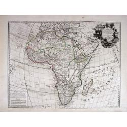
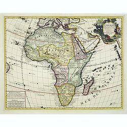
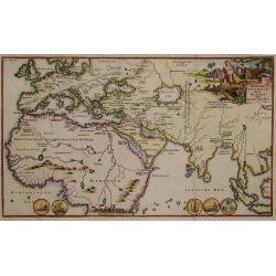
L' AFRIQUE, Dressée sur les Observations de Mrs. de l'Academie Royale des Sciences, et quelques autres, & sur les Memoi= res les plus recens.
This is a landmark map of Africa. This is the first map of Africa to show Africa without the two Nile River Ptolemaic-based source lakes. Delisle's last remaining majo...
Date: Paris, 1700-1708
Selling price: ????
Please login to see price!
Sold in 2013
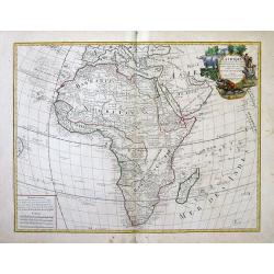
L\' AFRIQUE, Dressée sur les Observations de Mrs. de l\'Academie Royale des Sciences, et quelques autres, & sur les Memoi= res les plus recens.
This is a landmark map of Africa. This is the first map of Africa to show Africa without the two Nile River Ptolemaic-based source lakes. Delisle's last remaining major ...
Date: Paris, (1700) 1708
Selling price: ????
Please login to see price!
Sold in 2013
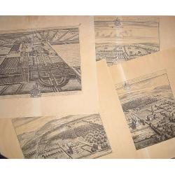
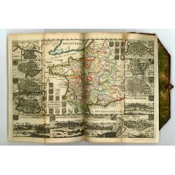
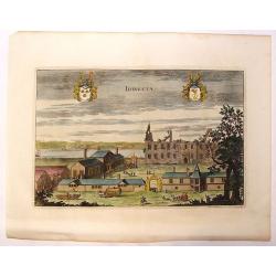
16 plates of English castles and houses.
16 very finely engraved and detailed bird's-eye views of the great English country houses, showing the architecture, formal gardens, and the surrounding landscape.The pla...
Date: London, 1708
Selling price: ????
Please login to see price!
Sold
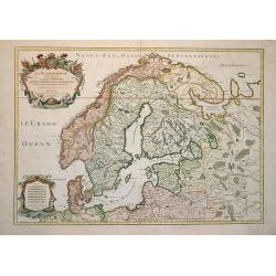
La Scandinavie et les Environs où sont les Royaumes.
Fine map of Scandinavia and the Baltic States with figurative armorial cartouche and small scale of miles. Engraved by Cordier.
Date: Paris, 1708
Selling price: ????
Please login to see price!
Sold in 2009
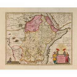
Aethiopia Superior vel Interior vulgo Abissinorum.
An attractive map of the Eastern African and the fictitious kingdom of Prester John. The map shows a major section of central and eastern Africa including Mozambique nort...
Date: Amsterdam, 1708
Selling price: ????
Please login to see price!
Sold in 2010
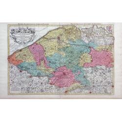
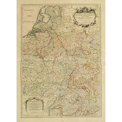
Le Comte de Flandre Divis en ses Chastellenies e Balliages?
Nicolas Sanson map of Belgium published by the Mortier publishing firm in Amsterdam with vibrant original color.
Date: Amsterdam, 1696-1708
Selling price: ????
Please login to see price!
Sold in 2010
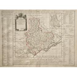
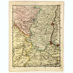
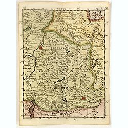
Carte du Diocese de Beziers.
Map of the Beziers and Languedoc regions of southwestern France by French cartographer de L'Isle. Includes indexes on both sides of the map, and a decorative cartouche in...
Date: Paris, 1708
Selling price: ????
Please login to see price!
Sold in 2010

La Scandinavie et les Environs où sont les Royaumes.
Fine map of Scandinavia and the Baltic States with figurative armorial cartouche and small scale of miles. Prepared by Sanson and published by Hubert Jaillot.Engraved by ...
Date: Paris, dated 1708
Selling price: ????
Please login to see price!
Sold in 2010
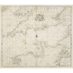
Nieuwe Wassende Graave Paskaart van't Canaal Tussen Engelandt en Vrankryk. . .
Chart showing the west cost of France and the south coast of England. Decorative cartouche lower right.
Date: Amsterdam, c.1708
Selling price: ????
Please login to see price!
Sold in 2010
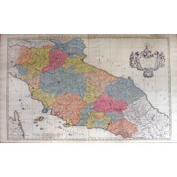
Estat du Grand Duc de Toscane, & Estats de L'Eglise / Estats de L'Eglise, et de Toscane. . .
A beautiful, large scale map of Tuscany, and the surrounding regions including the island of Elba and part of Corsica by Nicholas Sanson and published by Pierre Mortier. ...
Date: Amsterdam: 1696-1708
Selling price: ????
Please login to see price!
Sold in 2010
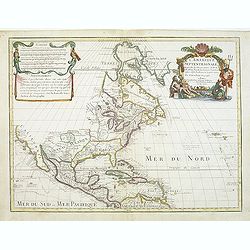
L'AMERIQUE SEPTENTRIONALE Dressée sur les Observations de Mr
One of the most influential maps of North America, laying the groundwork for much of the cartography of the 18th century. This is an early re-issue of De l'Isle's landmar...
Date: Paris, 1700 -1708
Selling price: ????
Please login to see price!
Sold in 2012
L\'Afrique dressée sur les observations de Mr de l\'académie Royale des Sciences. . .
Guillaume de l'Isle's (1675-1726) well deserved reputation as one of the foremost geographers of the 18th century meant that his maps were influential for many years afte...
Date: Amsterdam, 1708
Selling price: ????
Please login to see price!
Sold in 2011
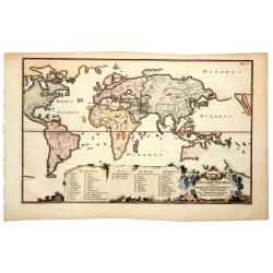
De tweede Weereld door Noachs dry Zonen bevolkt.
Charming Bible map showing the world as known after the Great Flood with Europe and parts of Asia and Africa. Title cartouche depicts Noah and his sons.
Date: Utrecht 1709
Selling price: ????
Please login to see price!
Sold
Le Cours de la Riviere du Rhein depuis sa Sources jusques a son Emboucheure ou sont distingues Tous les Etats et Souverainetes?
Handsome map detailing the course of the Rhine River, from its source in Switzerland, through Germany to its mouth on the North Sea, in the Netherlands. Also shows part o...
Date: Paris, 1709
Selling price: ????
Please login to see price!
Sold in 2016
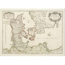
Le Royaume de Danemark subdivisé en ses Principales Provinces..
Handsome map of Denmark and part of Sweden. The map is extremely detailed with rivers, forests, cities and villages. The map is adorned with a striking cartouche flanked ...
Date: Paris, 1709
Selling price: ????
Please login to see price!
Sold in 2008
LES TABLETTES GUERRIERES, OU CARTES CHOISIES POUR LA COMMODITE DES OFFICIERS.
Most maps decorated with a borders showing town views and plans. The map of America with the island of California with an indented coastline and the place names R. d' Est...
Date: Amsterdam, 1709
Selling price: ????
Please login to see price!
Sold
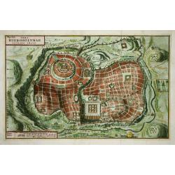
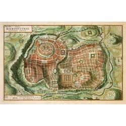
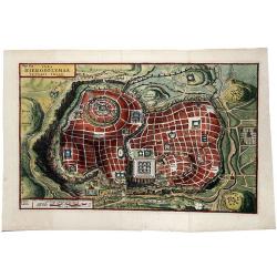
Vera Hierosolymae Veteris Imago
Delicately engraved imaginary plan of ancient Jerusalem based on Villalpando's foundation map of the city. The plan shows only the major religious sites, uncluttered by h...
Date: Amsterdam, 1709
Selling price: ????
Please login to see price!
Sold
![[Kawachi - Osaka Prefecture ]](/uploads/cache/90638-250x250.jpg)
[Kawachi - Osaka Prefecture ]
Rare Japanese colored woodcut map of Kawachi (Osaka Prefecture). Very large size and scale, with excellent detail. Additional Japanese text to sides. These large maps are...
Date: Osaka, Hoei 6, so 1709
Selling price: ????
Please login to see price!
Sold in 2008
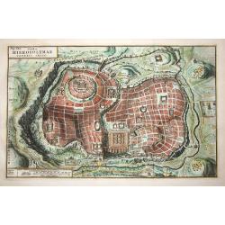
Vera Hierosolymae Veteris Imago
Delicately engraved imaginary plan of ancient Jerusalem based on Villalpando's foundation map of the city. The plan shows only the major religious sites, uncluttered by h...
Date: Amsterdam, 1709
Selling price: ????
Please login to see price!
Sold in 2009
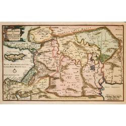
Descriptio Paradisi..
Nice map of the Middle East from the Mediterranean Sea to the Persian Gulf. The Garden of Eden is located in present-day Iraq, near the city of Babylon. Abraham's journey...
Date: Utrecht, 1709
Selling price: ????
Please login to see price!
Sold in 2009
Tabula Geographica Terrae Sanctae Auctore J. Bonfrerio Societa Jesu.
This uncommon map of Israel is by the Flemish theologian, Jacques Bonfrere. Oriented with north at top left, it is divided into the Twelve Tribes with a key at bottom. Th...
Date: Utrecht, 1709
Selling price: ????
Please login to see price!
Sold in 2009
Vera Hierosolymae Veteris Imago.
Delicately engraved imaginary town-plan of ancient Jerusalem based on Villalpando's foundation map of the city. The plan shows only the major religious sites, uncluttered...
Date: Amsterdam, 1709
Selling price: ????
Please login to see price!
Sold in 2009
Descriptio Paradisi..
Nice map of the Middle East from the Mediterranean Sea to the Persian Gulf. The Garden of Eden is located in present-day Iraq, near the city of Babylon. Abraham's journey...
Date: Utrecht 1709
Selling price: ????
Please login to see price!
Sold in 2009
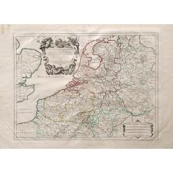
Les Dix-Sept Provinces des Pays-Bas, suivant qu\'elles sont possedees par les Roys de France et d\'Espagne et les Estates Generaux des Provinces-Unies
Map of the 17 provinces of the Low Countries, the territories grouped by the dukes of Burgundy and Emperor Charles V in the early 16th century, includes present day Belgi...
Date: Paris, 1709
Selling price: ????
Please login to see price!
Sold in 2010
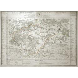
Carte Topographique du Diocese de Senlis.
Map of region surrounding the medieval town of Senlis, in the Picardy region of north-central France. Senlis is an ancient city going back to Roman times, and the monarch...
Date: Paris, 1709
Selling price: ????
Please login to see price!
Sold in 2010
Vera HIEROSOLYMAE Veteris Imago.
A delicately engraved imaginary plan of ancient Jerusalem based on Villalpando's foundation map of the city. The plan shows only the major religious sites, uncluttered by...
Date: Amsterdam, 1709
Selling price: ????
Please login to see price!
Sold in 2020
![TOTIUS ORBIS TERRARUM Tabula, Ejusque post diluvium divisio inter filios noachi.[California Island]](/uploads/cache/83666-250x250.jpg)
TOTIUS ORBIS TERRARUM Tabula, Ejusque post diluvium divisio inter filios noachi.[California Island]
An extremely scarce world map by Joseph Moxon's son James, and published featuring a curious separation of California from the rest of North America. The map clearly prov...
Date: Amsterdam, 1709
Selling price: ????
Please login to see price!
Sold in 2020
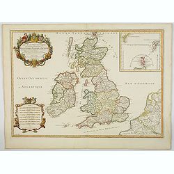
Les Isles Britanniques qui contienuent les Royaumes d'Angleterre, Escosse, et Irlande. . .
This is the 1709 Hubert Jaillot map of the British Isles. The map highlights the region from the Atlantic Ocean to the North Sea, and from the Orkney Islands to the Pas d...
Date: Paris, 1709
Selling price: ????
Please login to see price!
Sold in 2023
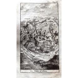
Les Bains d'Abano.
A small but detailed view of Abano Terme, with buildings, landscape, streets and people. From "Les Delices de l'Italie." by Alexandre de Rogissart.
Date: Leiden, 1709
Selling price: ????
Please login to see price!
Sold in 2021
![[Lot of 3 maps of America] AMERICA.](/uploads/cache/48389-250x250.jpg)
[Lot of 3 maps of America] AMERICA.
An excellent small map of the American continent by Herman Moll, 1709. Showing California as an island. 265 x 200mm.- South America, small map engraved for Walkers Geogra...
Date: London, 1709
Selling price: ????
Please login to see price!
Sold in 2022
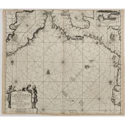
Pas-kaart van de Zee Kusten van Carthagena Tierra Firma, Costa Rica, ende Honduras…
This nautical chart shows the Caribbean coast, with Panama, Northern Colombia, Costa Rica, and Cartagena. Includes four insets: Port of Carthagena; S. Barnardo Islands;...
Date: Amsterdam, J. van Keulen, 1697-1709
Selling price: ????
Please login to see price!
Sold in 2023
Idingsta.
Fine hand-colored, copper engraving of Idingsta, Sweden.Jan van den Aveele or Aveelen (1650 - 1727) was a Dutch etcher and engraver. With compatriot Willem Swidde, he mad...
Date: Stockholm, 1709
Selling price: ????
Please login to see price!
Sold in 2013
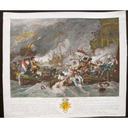
Combat de la Hogue (Sea battle between the Dutch, French, and English armies. )
Dramatic and wonderfully colored representation of the sea battle of The Hogue in 1692, with, on the right, the French trying to escape in small boats; coat of arms in lo...
Date: Paris, 1709
Selling price: ????
Please login to see price!
Sold in 2017
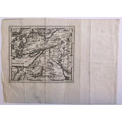
Untitled
A rare map of the Middle East region by Medrano. Engraved by Debruslins. Sheet size: 26.9cm x 19.5cm. Map size: 14.9cm x 13cm.
Date: 1709
Selling price: ????
Please login to see price!
Sold in 2016

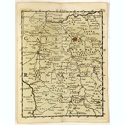
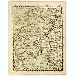
Carte du Duche de Bourgogne et des Comtez en Dependans.
An attractive 1709 map of Burgundy (Bourgogne), France, the popular wine producing region, covering the southern part of the region from Dole south as far as Pont-de-Veyl...
Date: Paris, 1709
Selling price: ????
Please login to see price!
Sold in 2023
TOTIUS ORBIS TERRARUM Tabula, Ejusque post diluvium divisio inter filios noachi.
An extremely scarce world map by Joseph Moxon's son James and published featuring a curious separation of California from the rest of North America.The map clearly provid...
Date: Amsterdam, 1709
Selling price: ????
Please login to see price!
Sold in 2019
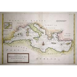
A Chart of the Mediterranean Sea According to Monsr. Berthelot &c.
An attractive map of the Mediterranean with the information taken from Monsieur Berthelot. Very accurate shows the whole of the Mediterranean centered on a Compass rose a...
Date: London, 1710
Selling price: ????
Please login to see price!
Sold in 2015
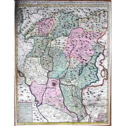
Carte nouvelle de Bergamasco, faisant partie des Etats de la Republique de Venise
Rare large scale map of the area around Bergamo, northern Italy, including the Lake Iseo (Lago d'Iseo). Very detailed map showing also mountain passes in the Alps! A ta...
Date: Amsterdam, c1710
Selling price: ????
Please login to see price!
Sold
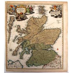
Magnae Britannia Pars Septentrionalis qua Regnum Scotiae.
Large,detailed and decorative map of Scotland with two superb cartouches. They are surrounded by mythical and allegorical figures, five putti, and Royal & Scottish ar...
Date: Nuremberg, 1710
Selling price: ????
Please login to see price!
Sold in 2014
![Le Royaume de Siam avec Les Royaumes Qui Luy sont Tributaries & c. / La Royaume de Siam avec les royaumes qui luy sont Tributaires, et les Isles de Sumatra, Andemaon, etc. . . [two sheet map]](/uploads/cache/33564-250x250.jpg)
Le Royaume de Siam avec Les Royaumes Qui Luy sont Tributaries & c. / La Royaume de Siam avec les royaumes qui luy sont Tributaires, et les Isles de Sumatra, Andemaon, etc. . . [two sheet map]
Influential map of Southeast Asia and the East Indies including modern day Thailand, southern Vietnam, Cambodia, Malaysia, Singapore, Borneo, Sumatra and Java. Ottens inc...
Date: Amsterdam, 1710
Selling price: ????
Please login to see price!
Sold in 2013
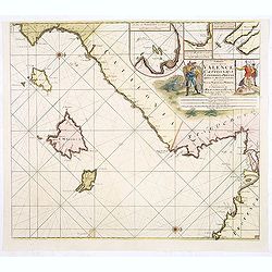
Paskaart van de Zee-kusten van Valence Catalonien Languedocq. . .
Fine sea chart showing the coast of Valencia, Catalonia, Languedoc, and Provence, and the islands of Majorca, Minorca and Ibiza.Title flanked by figures, topped by inset ...
Date: Amsterdam, c.1710
Selling price: ????
Please login to see price!
Sold in 2013
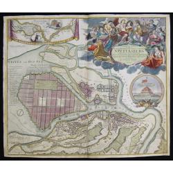
Topographische Vorstellung der Neuen Russischen Haupt-Residenz und See- Stadt St. Petersburg sammt ihrer zu erst aufgerichten Festung
Map shows a city map of St. Petersburg ,a beautiful cartouche, a location map of St. Petersburg and Chroncastle .
Date: Nuremberg, 1710
Selling price: ????
Please login to see price!
Sold in 2014
![Globus Coelestis in quo omnes Alterismi. . . [twelve engraved gores for a 20cm diameter celestial globe.]](/uploads/cache/34190-250x250.jpg)
Globus Coelestis in quo omnes Alterismi. . . [twelve engraved gores for a 20cm diameter celestial globe.]
Very Rare. Twelve engraved globe gores for a 20cm diameter celestial globe. There is a magnitude table above Phoenix to the left of the title cartouche, which is labelled...
Date: Nuremberg, ca.1710
Selling price: ????
Please login to see price!
Sold in 2014
![Nansenbushu Bankoku Shoka No Zu [Outline Map of All Countries of the Universe]](/uploads/cache/93929-250x250.jpg)
Nansenbushu Bankoku Shoka No Zu [Outline Map of All Countries of the Universe]
This map issued by Bundaiken Uhei is a great example for Japanese world maps representing Buddhist cosmology with real world cartography. It is the earliest one and - the...
Date: Kyoto, (Hoei 7 = Year of the Tiger) or 1710
Selling price: ????
Please login to see price!
Sold in 2014
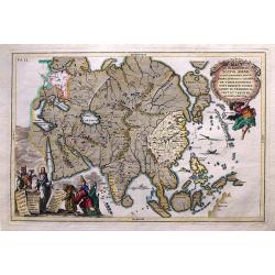
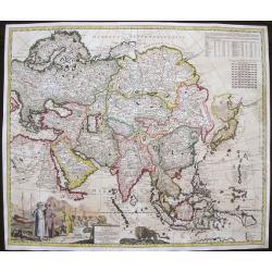
Repraesentatio totius Asiae...
Rare map of Asia by Scherer from Munich who was a cartographer, a Jesuit, and also a professor of mathematics. In this map the areas where Jesuit missions were present ar...
Date: Munich, ca 1710
Selling price: ????
Please login to see price!
Sold in 2015
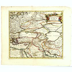
Tabula Altera Quae Continet Potissima Asiae et Reliqua Europae ac Africae.
Uncommon map covering a broad region centered on the Black and Caspian Seas. This was a region long disputed between the Christian and Islamic empires and the title carto...
Date: Amsterdam, 1710
Selling price: ????
Please login to see price!
Sold in 2015
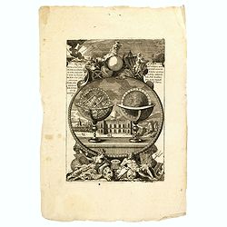
(Two globes, Paris observatory, Neptune. . .)
Decorative print showing a terrestrial globe and armillary sphere, surveying instruments, Neptune and an observatory in the back ground.Probably by Nicolas de Fer.
Date: Paris, ca. 1710
Selling price: ????
Please login to see price!
Sold in 2015
Asiae in Tabula Geographica Delineatio, ex officina Petri Schenkii.
Very fine, and very scarce of map of Asia. Beautifully, contemporary colored engraved map. The map is decorated with a wonderful, large and colored cartouche featuring Ar...
Date: Amsterdam, 1710
Selling price: ????
Please login to see price!
Sold in 2016
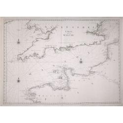
Carte de la Manche.
A large detailed sea chart of the English Channel has the coast of England from Cornwall round to Suffolk and South Wales. Below is the coast of France from La Baie de Do...
Date: Amsterdam, 1710
Selling price: ????
Please login to see price!
Sold in 2016
Principatus Cataloniae nec non Comitatum. . .
Detailed map centered on Catalonia. Lower right splendid title cartouche.Maps published in Germany during the 18th century are usually in body colors, with uncolored cart...
Date: Nurenberg, 1710
Selling price: ????
Please login to see price!
Sold in 2016
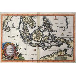
Insulae Indicae Cum Terris Circumvicinis.
Highly sought-after map of Southeast Asia. Includes today's Malaysia, Thailand, Vietnam, Singapore, Indonesia, Ceylon,< etc. Nova Hollandia (Australia) is depicted at ...
Date: Munich, c1710
Selling price: ????
Please login to see price!
Sold in 2016
![[World Polar Projection with insular California.]](/uploads/cache/95897-250x250.jpg)
[World Polar Projection with insular California.]
Original copper engraved map; page size 27 x 40 cm; from: 'Atlas Novus...Part III...Atlas Marianus'.A beautifully engraved world map on a North polar projection which is ...
Date: Munich, ca. 1710
Selling price: ????
Please login to see price!
Sold in 2017
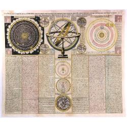
Nouvelle Carte de la Sphere pour Faire Connoitre les Divers...
A scarce and fascinating engraving showing two great depictions of the Copernican solar system on either side of an armillary sphere with four small maps (Western and Eas...
Date: Paris, 1710
Selling price: ????
Please login to see price!
Sold in 2017
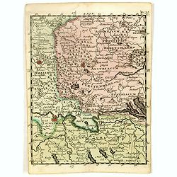
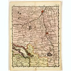
(Münster, Ravensberg, Lemgow, Westaphalia, etc.)
Rare miniature map including the towns of Münster, Ravensberg, Lemgow, Westaphalia, etc.. From "Le theatre De Bellone, Contenant 48. nouvelles Cartes Geographiques,...
Date: Amsterdam, 1710
Selling price: ????
Please login to see price!
Sold in 2023
(Sarlouis, Saarbrucke, Strassburg, etc.)
Rare miniature map including the towns of Sarlouis, Saarbrucke, Strassburg,, etc. From "Le theatre De Bellone, Contenant 48. nouvelles Cartes Geographiques, Des Paï...
Date: Amsterdam, 1710
Selling price: ????
Please login to see price!
Sold in 2016
(Heidelberg, Manheim, Wurtemberg, etc.)
A rare miniature map including the towns of Heidelberg, Manheim, Wurtemberg, etc. From "Le theatre De Bellone, Contenant 48. nouvelles Cartes Geographiques, Des Paï...
Date: Amsterdam, 1710
Selling price: ????
Please login to see price!
Sold in 2016
(Brisach, Basel, Montbelgard, etc.)
Rare miniature map including the towns of Brisach, Basel, Montbelgard,, etc. From "Le theatre De Bellone, Contenant 48. nouvelles Cartes Geographiques, Des Païs-Bas...
Date: Amsterdam, 1710
Selling price: ????
Please login to see price!
Sold in 2016
(Sens, Auxerre, Montargis, etc.)
Rare miniature map including the towns of Sens, Auxerre, Montargis, etc. From "Le theatre De Bellone, Contenant 48. nouvelles Cartes Geographiques, Des Païs-Bas Esp...
Date: Amsterdam, 1710
Selling price: ????
Please login to see price!
Sold in 2016
(Freiburg, Schafhausen, Villiengen, Lauffenburg, etc.)
Rare miniature map including the towns of Freiburg, Schafhausen, Villiengen, Lauffenburg, etc. From "Le theatre De Bellone, Contenant 48. nouvelles Cartes Geographiq...
Date: Amsterdam, 1710
Selling price: ????
Please login to see price!
Sold in 2019
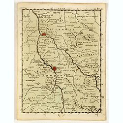
(Neyers, Moulins, Mont Morillon, etc.)
Rare miniature map including the towns of Neyers, Moulins, Mont Morillon, etc. From "Le theatre De Bellone, Contenant 48. nouvelles Cartes Geographiques, Des Païs-B...
Date: Amsterdam, 1710
Selling price: ????
Please login to see price!
Sold in 2016
(Ulm, Memmingen, Lindau, etc.)
Rare miniature map including the towns of Ulm, Memmingen, Lindau, etc. With BodenSee in lower left corner. From "Le theatre De Bellone, Contenant 48. nouvelles Carte...
Date: Amsterdam, 1710
Selling price: ????
Please login to see price!
Sold in 2016
(Cisteaux, Challon sur Saone, Charolles, etc.)
Rare miniature map including the towns of Cisteaux, Challon sur Saone, Charolles, etc. From "Le theatre De Bellone, Contenant 48. nouvelles Cartes Geographiques, Des...
Date: Amsterdam, 1710
Selling price: ????
Please login to see price!
Sold in 2018
(Neuenburg, Bern, Sitten Sion, etc.)
Rare miniature map of part of Switzerland, with Lake Geneva in lower left corner, including the towns of Neuenburg, Bern, Sitten Sion, etc. From "Le theatre De Bello...
Date: Amsterdam, 1710
Selling price: ????
Please login to see price!
Sold in 2017
(Canton Schweiz, Canton Bern, Canton Grisonne, etc.)
Rare miniature map of part of Switzerland, including the towns of Schweinfurt, Reineck, Hirschfeld, etc. From "Le theatre De Bellone, Contenant 48. nouvelles Cartes ...
Date: Amsterdam, 1710
Selling price: ????
Please login to see price!
Sold in 2017
(Chur, Worms, Cleven, etc.)
Rare miniature map of part of Switzeerland including the towns of Chur, Worms, Cleven, etc. From "Le theatre De Bellone, Contenant 48. nouvelles Cartes Geographiques...
Date: Amsterdam, 1710
Selling price: ????
Please login to see price!
Sold in 2016
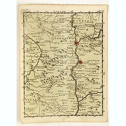
(Lyon, Vienne, Valence, etc.)
Rare miniature map including the towns of Lyon, Vienne, Valence, etc. From "Le theatre De Bellone, Contenant 48. nouvelles Cartes Geographiques, Des Païs-Bas Espagn...
Date: Amsterdam, 1710
Selling price: ????
Please login to see price!
Sold in 2018