![[The disposition of the Holy League fleet and that of the Ottoman Army during the Battle of Lepanto.]](/uploads/cache/45225-250x250.jpg)
[The disposition of the Holy League fleet and that of the Ottoman Army during the Battle of Lepanto.]
Very rare print of the disposition of the Holy League fleet and that of the Ottoman Army (semicircle) during the Battle of Lepanto (1571), published in the first edition ...
Place & Date: Venice, Giacomo Franco, 1598
Selling price: $90
Sold in 2023
![Golfo di Lepanto. [Map of the Gulf of Nafpaktos]](/uploads/cache/45227-250x250.jpg)
Golfo di Lepanto. [Map of the Gulf of Nafpaktos]
Very rare map of Gulf of Nafpaktos, known as Lepanto. It is named for Naupaktos, an important Athenian naval station in the Peloponnesian war. As a strategically crucial ...
Place & Date: Venice, Giacomo Franco, 1598
Selling price: $250
Sold in 2023
![Scharpanto [Map of Scharpantos]](/uploads/cache/45234-250x250.jpg)
Scharpanto [Map of Scharpantos]
Very rare map of Karpathos Island published in the first edition of "Viaggio da Venetia, a Costantinopoli. Per Mare, e per Terra, & infieme quello di Terra Santa...
Place & Date: Venice, Giacomo Franco, 1598
Selling price: $450
Sold
![Famagosta [Plan of Famagusta]](/uploads/cache/45239-250x250.jpg)
Famagosta [Plan of Famagusta]
Very rare plan of Famagusta, situated east of Nicosia and possesses the deepest harbour of the island. During the medieval period (especially under the maritime republics...
Place & Date: Venice, Giacomo Franco, 1598
Selling price: $375
Sold in 2020
![[View of Navarino]](/uploads/cache/45229-250x250.jpg)
[View of Navarino]
Very rare view of Navarino published in the first edition of "Viaggio da Venetia, a Costantinopoli. Per Mare, e per Terra, & infieme quello di Terra Santa. Da Gi...
Place & Date: Venice, Giacomo Franco, 1598
Selling price: $135
Sold in 2022
![[View of Napoli Romania]](/uploads/cache/45231-250x250.jpg)
[View of Napoli Romania]
Very rare view of Nafplion published in the first edition of "Viaggio da Venetia, a Costantinopoli. Per Mare, e per Terra, & infieme quello di Terra Santa. Da Gi...
Place & Date: Venice, Giacomo Franco, 1598
Selling price: $200
Sold in 2022
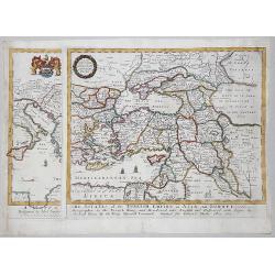
A MAPP of THE ESTATES of the TURKISH EMPIRE in ASIA, and EUROPE, 1669
A rare map of Turkey, Asia Minor, Cyprus, North Africa, Crimea, Southern part of Italy and Eastern Europe . This rare example is the earliest folio sized map of the regio...
Place & Date: London, 1669
Selling price: $350
Sold in 2020
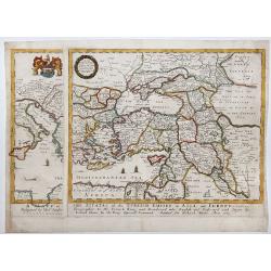
A MAPP of THE ESTATES of the TURKISH EMPIRE in ASIA, and EUROPE, 1669.
A copperplate partly colored map showing Arabie, Asia Minor & Cyprus. This rare example is the earliest folio sized map of the region to be engraved in England by Ric...
Place & Date: London, 1669
Selling price: $435
Sold in 2019
-250x250.JPG)
Scio
Extremely large 17th century copper engraving (printed from two copper plates) of the Greek island of Chios, just in front of the Turkish coast near Izmir, with that coas...
Place & Date: Amsterdam, 1698
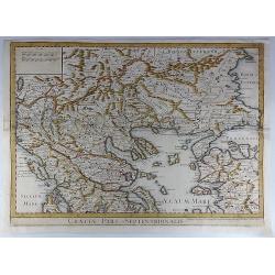
Graeciae Pars Septentrionalis.
A large and dramatic map by de L'Isle of the northern Greece, the Balkans, and Macedonia. Map extent covers from Dalmatia east to the Black Sea (Pontus Euxinus) and south...
Place & Date: London, 1725
Selling price: $46
Sold in 2018
Carte pour la Route de Xerxes dans la Grece et Pour l'Expedition du Jeune Cyprus et la Retraite des Dix Mille.
A striking map of Greece. The map for the Route of Xerxes in Greece and For the Expedition of the Young Cyprus, and the Retreat of the Ten Thousand. It is from “METHODE...
Place & Date: Paris, 1729
Selling price: $115
Sold in 2020
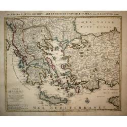
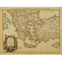
Carte de la Grece.
A striking, large map detailing Greece, the western part of Turkey and extending to show Albania, Macedonia and part of Cyprus. Latin title at top "Accurata Totius A...
Place & Date: Amsterdam, 1730
Selling price: $220
Sold in 2008
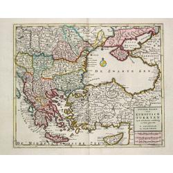
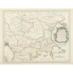
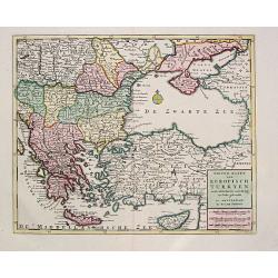
Nieuwe Kaart van Europisch Turkyen.
Izaak Tirion (d. 1769) Amsterdam publisher. His ' Nieuwe en beknopte handatlas' saw 6 editions between before 1740 and after 1784. Also ' Tegenwoordige staat van alle vol...
Place & Date: Amsterdam, 1733
Selling price: $275
Sold
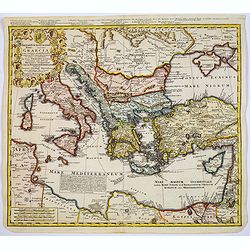
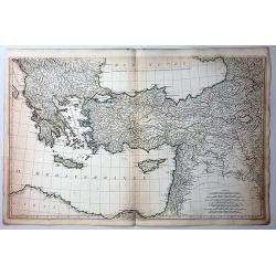
Imperii Turcici Europaei Terra, in primis Graecia. . .
An unusual map showing the Turkish Empire, extending from Corsica and Sardinia in the west, to Asia Minor, Cyprus and the Black Sea in the east. Parts of North Africa als...
Place & Date: Nuremberg, 1740
Selling price: $205
Sold in 2017
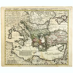
Imperii Turcici Europaei Terra, in primis Graecia. . .
An unusual map showing the Turkish Empire, extending from Corsica and Sardinia in the west, to Asia Minor, Cyprus and the Black Sea in the east. Parts of North Africa als...
Place & Date: Nuremberg, 1740
Selling price: $175
Sold in 2020
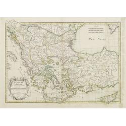
Carte de la Grece dressée sur un grand nombre de memoires..
Detailed copper-engraved map of Greece with its neighbouring countries, including southern Italy and part of Cyprus. Relief shown pictorially. With large decorative title...
Place & Date: Amsterdam c. 1745
Selling price: $355
Sold
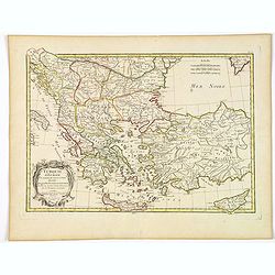
Carte de la Grece dressée sur un grand nombre de memoires..
Detailed copper-engraved map of Greece with its neighboring countries, including southern Italy and part of Cyprus. Relief shown pictorially. With large decorative title ...
Place & Date: Paris, 1780
Selling price: $200
Sold in 2009
Bottom Part Only of Huge Map centering on Greece.
A large bottom portion of a huge map centering on Greece. The original map was about 41" x 32".This section covers the area between Libya and Iraq on the south ...
Place & Date: Anon, ca. 1780
Selling price: $55
Sold in 2017
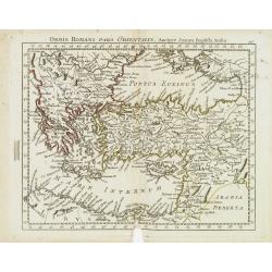
Orbis Romani Pars Orientalis. . .
Unusual map of Ancient Turkey, including a curiously shaped Cyprus, prepared by Nolin and published by L.J. Mondhare for his Atlas Général a l'usage des colleges et mai...
Place & Date: Paris, 1781
Selling price: $80
Sold in 2023
Turquie d'Europe et partie de celle d'Asie..
Attractive map centered on the Aegean Sea, encompassing the whole Balkan Peninsula and part of Turkey.It includes also Crete and Cyprus. Decorated with a decorative title...
Place & Date: Paris, ca 1783
Selling price: $70
Sold in 2011
Turquie d'Europe et partie de celle d'Asie divisee. . .
An attractive map centered on the Aegean Sea, encompassing the whole Balkan Peninsula and part of Turkey.It includes also Crete and Cyprus. Decorated with a pretty title ...
Place & Date: Paris, ca 1783
Selling price: $27
Sold in 2021
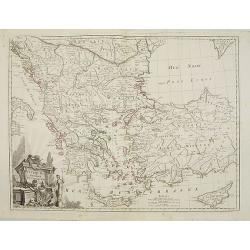
Turquie d'Europe..
Detailed map encompassing present day Greece and part of Turkey. In the lower right corner a large depiction of Cyprus. Venetian edition of the map by Bellin, to whom San...
Place & Date: Venice, 1776 - 1784
Selling price: $250
Sold in 2008
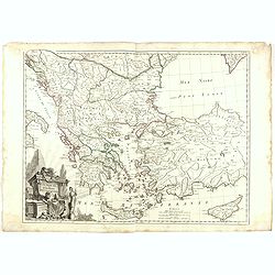
Turquie d'Europe..
Detailed map encompassing present day Greece and part of Turkey. In the lower right corner a large depiction of Cyprus. With ornamental title cartouche and noteworthy top...
Place & Date: Venice, 1776 - 1784
Selling price: $150
Sold in 2018
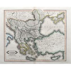
Turkey in Europe, Greece & the Ionian Islands.
A scarce and a highly detailed map of Turkey and Greece. Includes the Balkans, Cyprus, Crimea and the Black Sea. An attractive example.
Place & Date: Edinburgh, ca 1835
Selling price: $35
Sold in 2020
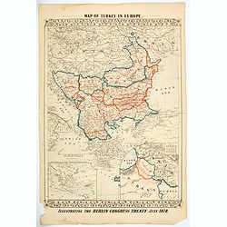
Map of Turkey in Europe. Illustrating the Berlin CongressTtreaty, July 1878.
An unusual map of Turkey, Greece, the Balkans, Austria and a part of the Ukraine, illustrating the nations created under the Berlin Congress Treaty, as well as the lands ...
Place & Date: Philadelphia, 1878
Selling price: $50
Sold in 2021
Nieuwe Kaart van Europisch Turkyen.
Izaak Tirion (d.1769) Amsterdam publisher. His Nieuwe en beknopte handatlas saw 6 editions between before 1740 and after 1784. Also Tegenwoordige staat van alle volkeren,...
Place & Date: Amsterdam, 1733.
Selling price: $225
Sold