![[The disposition of the Holy League fleet and that of the Ottoman Army during the Battle of Lepanto.]](/uploads/cache/45225-250x250.jpg)
[The disposition of the Holy League fleet and that of the Ottoman Army during the Battle of Lepanto.]
Very rare print of the disposition of the Holy League fleet and that of the Ottoman Army (semicircle) during the Battle of Lepanto (1571), published in the first edition ...
Place & Date: Venice, Giacomo Franco, 1598
Selling price: $90
Sold in 2023
![Golfo di Lepanto. [Map of the Gulf of Nafpaktos]](/uploads/cache/45227-250x250.jpg)
Golfo di Lepanto. [Map of the Gulf of Nafpaktos]
Very rare map of Gulf of Nafpaktos, known as Lepanto. It is named for Naupaktos, an important Athenian naval station in the Peloponnesian war. As a strategically crucial ...
Place & Date: Venice, Giacomo Franco, 1598
Selling price: $250
Sold in 2023
![Scharpanto [Map of Scharpantos]](/uploads/cache/45234-250x250.jpg)
Scharpanto [Map of Scharpantos]
Very rare map of Karpathos Island published in the first edition of "Viaggio da Venetia, a Costantinopoli. Per Mare, e per Terra, & infieme quello di Terra Santa...
Place & Date: Venice, Giacomo Franco, 1598
Selling price: $450
Sold
![Famagosta [Plan of Famagusta]](/uploads/cache/45239-250x250.jpg)
Famagosta [Plan of Famagusta]
Very rare plan of Famagusta, situated east of Nicosia and possesses the deepest harbour of the island. During the medieval period (especially under the maritime republics...
Place & Date: Venice, Giacomo Franco, 1598
Selling price: $375
Sold in 2020
![[View of Navarino]](/uploads/cache/45229-250x250.jpg)
[View of Navarino]
Very rare view of Navarino published in the first edition of "Viaggio da Venetia, a Costantinopoli. Per Mare, e per Terra, & infieme quello di Terra Santa. Da Gi...
Place & Date: Venice, Giacomo Franco, 1598
Selling price: $135
Sold in 2022
![[View of Napoli Romania]](/uploads/cache/45231-250x250.jpg)
[View of Napoli Romania]
Very rare view of Nafplion published in the first edition of "Viaggio da Venetia, a Costantinopoli. Per Mare, e per Terra, & infieme quello di Terra Santa. Da Gi...
Place & Date: Venice, Giacomo Franco, 1598
Selling price: $200
Sold in 2022
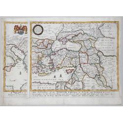
A MAPP of THE ESTATES of the TURKISH EMPIRE in ASIA, and EUROPE, 1669
A rare map of Turkey, Asia Minor, Cyprus, North Africa, Crimea, Southern part of Italy and Eastern Europe . This rare example is the earliest folio sized map of the regio...
Place & Date: London, 1669
Selling price: $350
Sold in 2020
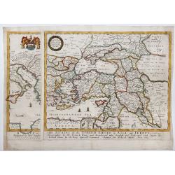
A MAPP of THE ESTATES of the TURKISH EMPIRE in ASIA, and EUROPE, 1669.
A copperplate partly colored map showing Arabie, Asia Minor & Cyprus. This rare example is the earliest folio sized map of the region to be engraved in England by Ric...
Place & Date: London, 1669
Selling price: $435
Sold in 2019
-250x250.JPG)
Scio
Extremely large 17th century copper engraving (printed from two copper plates) of the Greek island of Chios, just in front of the Turkish coast near Izmir, with that coas...
Place & Date: Amsterdam, 1698
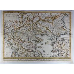
Graeciae Pars Septentrionalis.
A large and dramatic map by de L'Isle of the northern Greece, the Balkans, and Macedonia. Map extent covers from Dalmatia east to the Black Sea (Pontus Euxinus) and south...
Place & Date: London, 1725
Selling price: $46
Sold in 2018