Search Listings matching "cyprus" in Europe
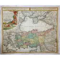
![[untitled map of Spain and Portugal] Al Molto Mag et Ecc Alessandro Serego, Che lo studio della Geografia..](/uploads/cache/25016-250x250.jpg)
[untitled map of Spain and Portugal] Al Molto Mag et Ecc Alessandro Serego, Che lo studio della Geografia..
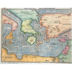
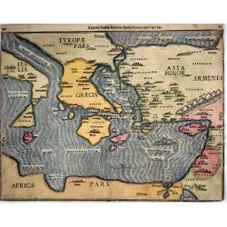
A rare map of Spain and Portugal, with an oversized Majorca. One of the first printed maps of Cyprus. A unique opportunity to acquire a fine example of a map from the ear...
Place & Date: Venice, 1566
Selling price: $9000
Sold in 2010
![Calaris [on sheet with] Malta [and] Rhodus [and] Famagusta.](/uploads/cache/33682-250x250.jpg)
Calaris [on sheet with] Malta [and] Rhodus [and] Famagusta.
One sheet with very desirable and early town-plans of four Mediterranean island capitals—Cagliari (Sardinia), Valletta (Malta), Rhodes, and Famagusta (Cyprus). "C...
Place & Date: Cologne, (1572) 1577
Selling price: $550
Sold in 2015
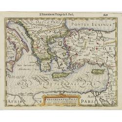
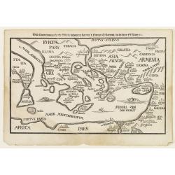
Tafel Der Lender Darin Der Apostel Paulus Geprediget Hat.
The Eastern Mediterranean, from the "Itinerarium Sacrae Scripturae", showing Italy, Sicily, Greece, Cyprus, Asia Minor, the Holy Land and North Africa, with cit...
Place & Date: Magdeburg, 1585
Selling price: $400
Sold in 2014
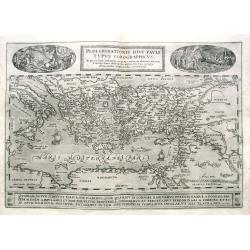
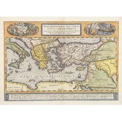
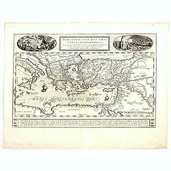
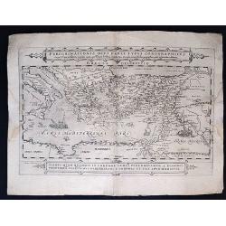
Peregrinationis Divi Pauli Typus Corographicus...
Ortelius's map of Paulus's travels from his Atlas Theatrum Orbis Terrarum. It covers the Mediterranean Sea from Italy and Sicily until the Near East and Egypt, with Cypru...
Place & Date: Antwerp, 1587
Selling price: $180
Sold in 2019
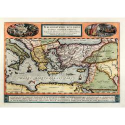
Peregrinationis divi Pauli typus corographicus
Hand colored map of the Eastern Mediterranean by Abraham Ortelius. Covering the Mediterranean Sea between Israel and Sicily with Cyprus, Italy, Greece and Turkey. With tw...
Place & Date: Antwerp, 1592
Selling price: $700
Sold in 2010
Natoliam Moderni dicunt tam partem quam Asiam minrem appelauere veteres (with Cyprus)
Engraved by Van Deutecum, this is a spectacular example of the 1593 edition of the very rare De Jode's map of the Eastern Mediterranean and Asia Minor. It has two title c...
Place & Date: Antwerp, 1593
Selling price: $2900
Sold in 2014
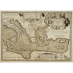
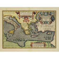
Aeneae Troiani navigatio..
After the destruction of Troy, Aenaeas is reported to have roamed the seas for seven years, as described in the writings of Xenophon, Ovidius, Lycrophonous, but most exte...
Place & Date: Antwerp 1595
Selling price: $320
Sold
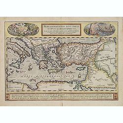
Peregrinationis Divi Pauli Typus Corographicus . . .
A splendid map depicting the travels of Paulus. With two fine scenes in top. Showing the countries along the Mediterranean, including Cyprus and Italy. Based on Mercator'...
Place & Date: Antwerp, 1595
Selling price: $1300
Sold
Peregrinationis Divi Pauli Typus...
A splendid map depicting the travels of Paulus. With two fine scenes in top. Showing the countries along the Mediterranean, including Cyprus and Italy. Based on Mercator'...
Place & Date: Antwerp, 1595
Selling price: $600
Sold in 2014
Tafel der Lender / darin der Apostel Paulus geprediget hat.
Woodcut showing the Eastern Mediterranean from the "Itinerarium Sacrae Scripturae", showing Italy, Sicily, Greece, Cyprus, Asia Minor, the Holy Land and North A...
Place & Date: Magdeburg, 1595
Selling price: $340
Sold in 2017
![Rovigno [View of Rovinj]](/uploads/cache/45192-250x250.jpg)
Rovigno [View of Rovinj]
Very rare view of Rovinj in Croatia situated on the north Adriatic Sea. Located on the western coast of the Istrian peninsula, it is a popular tourist resort and an activ...
Place & Date: Venice, Giacomo Franco, 1598
Selling price: $150
Sold in 2023
![[The disposition of the Holy League fleet and that of the Ottoman Army during the Battle of Lepanto.]](/uploads/cache/45225-250x250.jpg)
[The disposition of the Holy League fleet and that of the Ottoman Army during the Battle of Lepanto.]
Very rare print of the disposition of the Holy League fleet and that of the Ottoman Army (semicircle) during the Battle of Lepanto (1571), published in the first edition ...
Place & Date: Venice, Giacomo Franco, 1598
Selling price: $90
Sold in 2023
![Golfo di Lepanto. [Map of the Gulf of Nafpaktos]](/uploads/cache/45227-250x250.jpg)
Golfo di Lepanto. [Map of the Gulf of Nafpaktos]
Very rare map of Gulf of Nafpaktos, known as Lepanto. It is named for Naupaktos, an important Athenian naval station in the Peloponnesian war. As a strategically crucial ...
Place & Date: Venice, Giacomo Franco, 1598
Selling price: $250
Sold in 2023
![Scharpanto [Map of Scharpantos]](/uploads/cache/45234-250x250.jpg)
Scharpanto [Map of Scharpantos]
Very rare map of Karpathos Island published in the first edition of "Viaggio da Venetia, a Costantinopoli. Per Mare, e per Terra, & infieme quello di Terra Santa...
Place & Date: Venice, Giacomo Franco, 1598
Selling price: $450
Sold
![Famagosta [Plan of Famagusta]](/uploads/cache/45239-250x250.jpg)
Famagosta [Plan of Famagusta]
Very rare plan of Famagusta, situated east of Nicosia and possesses the deepest harbour of the island. During the medieval period (especially under the maritime republics...
Place & Date: Venice, Giacomo Franco, 1598
Selling price: $375
Sold in 2020
![Polla/Viaggio Da Venetia [Pola in Istria] Rare 1st edition](/uploads/cache/84452-250x250.jpg)
Polla/Viaggio Da Venetia [Pola in Istria] Rare 1st edition
Very rare view of the City of Pola in Istria. From the rare first edition of "Viaggio da Venetia, a Costantinopoli. Per Mare, e per Terra, & infieme quello di Te...
Place & Date: Venice, Giacomo Franco, 1598
Selling price: $130
Sold in 2021
![[View of Navarino]](/uploads/cache/45229-250x250.jpg)
[View of Navarino]
Very rare view of Navarino published in the first edition of "Viaggio da Venetia, a Costantinopoli. Per Mare, e per Terra, & infieme quello di Terra Santa. Da Gi...
Place & Date: Venice, Giacomo Franco, 1598
Selling price: $135
Sold in 2022
![[View of Napoli Romania]](/uploads/cache/45231-250x250.jpg)
[View of Napoli Romania]
Very rare view of Nafplion published in the first edition of "Viaggio da Venetia, a Costantinopoli. Per Mare, e per Terra, & infieme quello di Terra Santa. Da Gi...
Place & Date: Venice, Giacomo Franco, 1598
Selling price: $200
Sold in 2022
Peregrinatio Pauli..
Early map showing the travels of Paulus, including Greece, Crete, Turkey, Palestine and Cyprus.From the first French-text edition of Jodocus Hondius'' Atlas Minor.Shortly...
Place & Date: Amsterdam, 1608
Selling price: $220
Sold in 2008
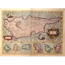
Cyprus Ins
From the "Gerardi Mercatoris Atlas sive Cosmographicae meditationes de fabrica mundi et fabricati figura denuò auctus". Latin text on verso. An elegant map of ...
Place & Date: Amsterdam, c 1611
Selling price: $800
Sold
Aeneae Troiani Navigatio.
From the famous historical Atlas Parergon. The map is ornated with four cartouches, on top in the middle the title cartouche, on the middle right, underneath a decorative...
Place & Date: Antwerp, 1612
Selling price: $1200
Sold in 2013
Peregrinationis Divi Pauli Typus…
A splendid map depicting the travels of Paulus. With two fine scenes in top. Showing the countries along the Mediterranean, including Cyprus and Italy. Based on Mercator'...
Place & Date: Antwerp, 1624
Selling price: $350
Sold in 2023
Peregrinationis Divi Pauli Typus Corographicus. . .
Peregrinationis Divi Pauli Typus Corographicus In quo & novi testamenti, in primis autem apostulorum historiae, a Sancto Luca descripta, omnia fere loca geographica, ...
Place & Date: Paris, 1655
Selling price: $550
Sold in 2020
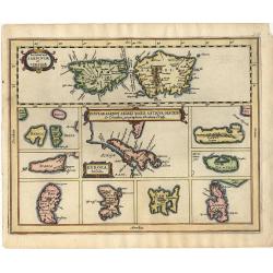
Insular Aliquot Aegaei Maris Antiqua Descrip.
A small map of Mediterranean islands based in part on Ortelius. The central map is of the Greek island Euboea and is surrounded by small maps of other islands. This compo...
Place & Date: Amsterdam 1661
Selling price: $80
Sold
Deze Caerte van de reysen Pauli..
Rare wood block map, depicting the Mediterranean, with an over-sized Cyprus from the final Dutch edition of Heinrich Bünting's famous Itinerarium Sacrae Scripturae, a bo...
Place & Date: Amsterdam 1663
Selling price: $420
Sold
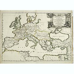
Geographia Synodica, Sive Regionum, Vrbium, et Locorum vbi Celebrata Sunt Concilia Oecumenica, Nationalia, Provincialia et Synodi Dioecesanae
Attractive historical map of Europe, the Mediterranean, and northern Africa. Extends to Cyprus and the Holy Land. Based on the cartography of Guillaume Samson and publish...
Place & Date: Paris, 1666
Selling price: $75
Sold in 2020
Geographia Synodica, Sive Regionum, Vrbium, et Locorum vbi Celebrata Sunt Concilia Oecumenica, Nationalia, Provincialia et Synodi Dioecesanae
Attractive historical map of Europe, the Mediterranean, and northern Africa. Extends to Cyprus and the Holy Land. Based on the cartography of Guillaume Samson and publish...
Place & Date: Paris, 1666
Selling price: $100
Sold in 2016
Europa Vetus.
Attractive historical map of Europe, the Mediterranean, and northern Africa. Extends to Cyprus and the Holy Land. Based on the cartography of Guillaume Samson and publish...
Place & Date: Paris, 1668
Selling price: $135
Sold in 2013
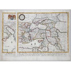
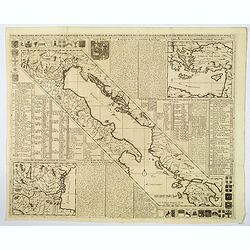
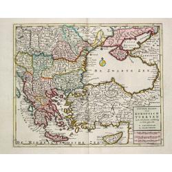
A MAPP of THE ESTATES of the TURKISH EMPIRE in ASIA, and EUROPE, 1669
A rare map of Turkey, Asia Minor, Cyprus, North Africa, Crimea, Southern part of Italy and Eastern Europe . This rare example is the earliest folio sized map of the regio...
Place & Date: London, 1669
Selling price: $350
Sold in 2020
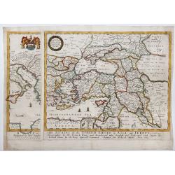
A MAPP of THE ESTATES of the TURKISH EMPIRE in ASIA, and EUROPE, 1669.
A copperplate partly colored map showing Arabie, Asia Minor & Cyprus. This rare example is the earliest folio sized map of the region to be engraved in England by Ric...
Place & Date: London, 1669
Selling price: $435
Sold in 2019
Pas Kaert der Middelandsche.
Companion sea chart of lot 15518 from Doncker?s Nieuw Groot Stuurmans Straets-Book depicting eastern half of Mediterranean covering Italy and Cyprus and entire eastern sh...
Place & Date: Amsterdam 1670
Selling price: $755
Sold
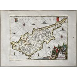
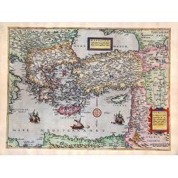
Cyprus Insula
Title in a cartouche with putti and Neptune at bottom right, two coats-of-arms at top corners.From: O. Dapper, Naukeurige Beschrijving der Eilanden in de Archipel der Mid...
Place & Date: Amsterdam, 1688
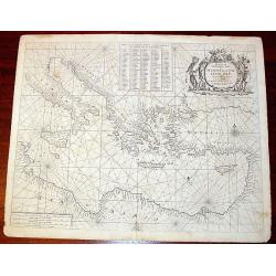
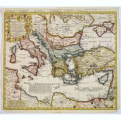
Parte Orientale del Mediterraneo..
A beautiful map depicting the eastern part of the Mediterranean Basin, including a nice representation of Cyprus. With decorative title cartouche and scale cartouche.Hist...
Place & Date: Venice 1690
Selling price: $850
Sold
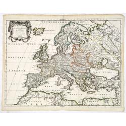
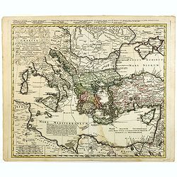
![Parte orientale dell' Europa . . . [Russia]](/uploads/cache/29452-250x250.jpg)
Parte orientale dell' Europa . . . [Russia]
Eastern part of Europe. The map extends from the Turkey (with Cyprus) and the Black sea, Ukraine and part of the Caspian Sea, up till Nova Zembla. Only the west coast of ...
Place & Date: Venice, 1695
Selling price: $1100
Sold in 2010
![Parte orientale dell' Europa . . . [Eastern part of Europe with Russia and map of Iceland on verso]](/uploads/cache/39638-250x250.jpg)
Parte orientale dell' Europa . . . [Eastern part of Europe with Russia and map of Iceland on verso]
Eastern part of Europe of a two sheet map. On the verso a map of Iceland "Isola d'Islanda". The Europe map extends from the Turkey (with Cyprus) and the Black s...
Place & Date: Venice, 1695
Selling price: $950
Sold in 2020
-250x250.JPG)
Scio
Extremely large 17th century copper engraving (printed from two copper plates) of the Greek island of Chios, just in front of the Turkish coast near Izmir, with that coas...
Place & Date: Amsterdam, 1698
Carte de Geographie des Differents Etats de la Republique de Venise. . .
An attractive and detailed engraving of the Gulf of Venice and adjacent Italian and Dalmatian coastlines. The main map runs diagonally across the sheet with inset detail ...
Place & Date: Amsterdam, 1710
Selling price: $220
Sold in 2019
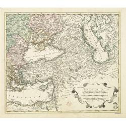
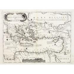
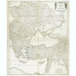
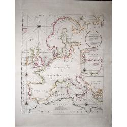
Area between the Black Sea and the Caspian Sea.
Nice and scarce map encompassing part of the Near East and the area comprehended between the Black Sea and the Caspian Sea.Centered on Turkey, with an oversized Cyprus. I...
Place & Date: Nuremberg, ca 1720
Selling price: $350
Sold in 2016
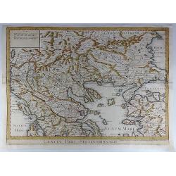
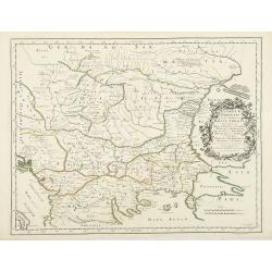
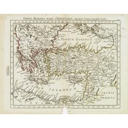
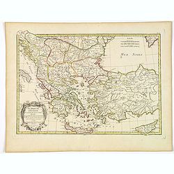
Graeciae Pars Septentrionalis.
A large and dramatic map by de L'Isle of the northern Greece, the Balkans, and Macedonia. Map extent covers from Dalmatia east to the Black Sea (Pontus Euxinus) and south...
Place & Date: London, 1725
Selling price: $46
Sold in 2018
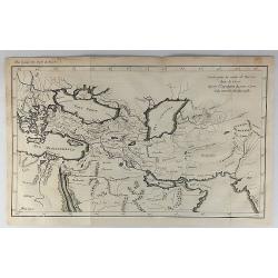
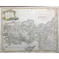
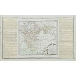
Carte pour la Route de Xerxes dans la Grece et Pour l'Expedition du Jeune Cyprus et la Retraite des Dix Mille.
A striking map of Greece. The map for the Route of Xerxes in Greece and For the Expedition of the Young Cyprus, and the Retreat of the Ten Thousand. It is from “METHODE...
Place & Date: Paris, 1729
Selling price: $115
Sold in 2020
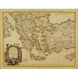
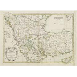
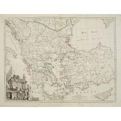
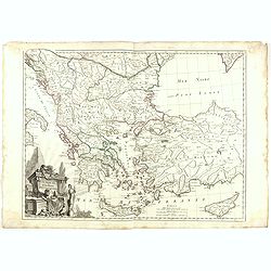
Carte de la Grece.
A striking, large map detailing Greece, the western part of Turkey and extending to show Albania, Macedonia and part of Cyprus. Latin title at top "Accurata Totius A...
Place & Date: Amsterdam, 1730
Selling price: $220
Sold in 2008
Nieuwe Kaart van Europisch Turkyen.
Izaak Tirion (d. 1769) Amsterdam publisher. His ' Nieuwe en beknopte handatlas' saw 6 editions between before 1740 and after 1784. Also ' Tegenwoordige staat van alle vol...
Place & Date: Amsterdam, 1733
Selling price: $275
Sold
Imperii Turcici Europaei Terra, in primis Graecia. . .
An unusual map showing the Turkish Empire, extending from Corsica and Sardinia in the west, to Asia Minor, Cyprus and the Black Sea in the east. Parts of North Africa als...
Place & Date: Nuremberg, 1740
Selling price: $205
Sold in 2017
Imperii Turcici Europaei Terra, in primis Graecia. . .
An unusual map showing the Turkish Empire, extending from Corsica and Sardinia in the west, to Asia Minor, Cyprus and the Black Sea in the east. Parts of North Africa als...
Place & Date: Nuremberg, 1740
Selling price: $175
Sold in 2020
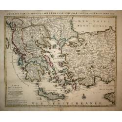
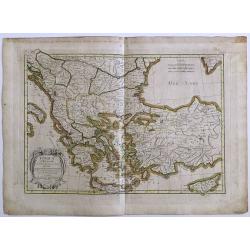
Carte de la Grece dressée sur un grand nombre de memoires..
Detailed copper-engraved map of Greece with its neighbouring countries, including southern Italy and part of Cyprus. Relief shown pictorially. With large decorative title...
Place & Date: Amsterdam c. 1745
Selling price: $355
Sold
Carte de l'Asie Minevre. . .
A striking map centred on the Black Sea, and the geographical regions surrounding it. Map also shows Asia Minor, Crete, Cyprus, northern Syria, Iraq, Georgia, the Crimea,...
Place & Date: Nuremburg, 1748
Selling price: $160
Sold in 2018
Asia Minor In Suas Partes, Seu Provincias Divisa . . .
Very large, very detailed map showing Cyprus, Asia Minor and contiguous Iùislands and the Black Sea region, from De Vaugondy's Atlas Universel.
Place & Date: Paris, 1756
Troisieme partie de la carte d'Europe, contenant le midi de la Russie, la Pologne, et la Hongrie, la Turquie y compris celle d'Asie presqu'entiere. . .
Wall map sized map of Russia, Crimea, Turkey, Cyprus and Holey Land. Centered on the Black Sea. Prepared by Jean Baptiste Bourguignon d'Anville (1697-1782). Ornamental ca...
Place & Date: Paris, 1760
Selling price: $500
Sold in 2011
Carte de la Grece dressée sur un grand nombre de memoires..
Detailed copper-engraved map of Greece with its neighboring countries, including southern Italy and part of Cyprus. Relief shown pictorially. With large decorative title ...
Place & Date: Paris, 1780
Selling price: $200
Sold in 2009
Bottom Part Only of Huge Map centering on Greece.
A large bottom portion of a huge map centering on Greece. The original map was about 41" x 32".This section covers the area between Libya and Iraq on the south ...
Place & Date: Anon, ca. 1780
Selling price: $55
Sold in 2017
Orbis Romani Pars Orientalis. . .
Unusual map of Ancient Turkey, including a curiously shaped Cyprus, prepared by Nolin and published by L.J. Mondhare for his Atlas Général a l'usage des colleges et mai...
Place & Date: Paris, 1781
Selling price: $80
Sold in 2023
Turquie d'Europe et partie de celle d'Asie..
Attractive map centered on the Aegean Sea, encompassing the whole Balkan Peninsula and part of Turkey.It includes also Crete and Cyprus. Decorated with a decorative title...
Place & Date: Paris, ca 1783
Selling price: $70
Sold in 2011
Turquie d' Europe
This finely engraved map is roughly centered on Greece, including the islands of Crete and Cyprus. The map covers the region from Bosnia and Serbia to the Black Sea and C...
Place & Date: Paris, 1783
Selling price: $70
Sold in 2016
Turquie d'Europe et partie de celle d'Asie divisee. . .
An attractive map centered on the Aegean Sea, encompassing the whole Balkan Peninsula and part of Turkey.It includes also Crete and Cyprus. Decorated with a pretty title ...
Place & Date: Paris, ca 1783
Selling price: $27
Sold in 2021
Turquie d'Europe..
Detailed map encompassing present day Greece and part of Turkey. In the lower right corner a large depiction of Cyprus. Venetian edition of the map by Bellin, to whom San...
Place & Date: Venice, 1776 - 1784
Selling price: $250
Sold in 2008
Turquie d'Europe..
Detailed map encompassing present day Greece and part of Turkey. In the lower right corner a large depiction of Cyprus. With ornamental title cartouche and noteworthy top...
Place & Date: Venice, 1776 - 1784
Selling price: $150
Sold in 2018
Turquie Européenne, Avec les Pays limitrophes..
Copper engraved map centered on Greece, extending northwards and eastwards to include the Balkans and Ukraine as well as Cyprus.The map is flanked by two columns of Frenc...
Place & Date: Paris, 1790
Selling price: $120
Sold in 2012
Uebersicht der Europaeischen Seeküsten verfasst von Herrn Caington Bowles. . .
A very decorative, very large map showing all European coasts: includes North sea, East sea, Atlantic ocean and the Mediterranean sea. On inset you see the eastern Medite...
Place & Date: Vienna, 1791
Selling price: $200
Sold in 2020
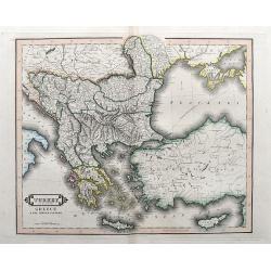
Turkey in Europe, Greece & the Ionian Islands.
A scarce and a highly detailed map of Turkey and Greece. Includes the Balkans, Cyprus, Crimea and the Black Sea. An attractive example.
Place & Date: Edinburgh, ca 1835
Selling price: $35
Sold in 2020
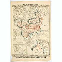
Map of Turkey in Europe. Illustrating the Berlin CongressTtreaty, July 1878.
An unusual map of Turkey, Greece, the Balkans, Austria and a part of the Ukraine, illustrating the nations created under the Berlin Congress Treaty, as well as the lands ...
Place & Date: Philadelphia, 1878
Selling price: $50
Sold in 2021
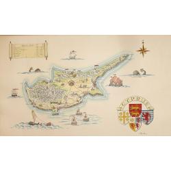
A Pictorial Map of Cyprus.
An attractive hand painted map of Cyprus a scroll cartouche has the Historical dates of the Islands occupation, the map centers on Nicosia. The sea has galleons, sea mons...
Place & Date: ca. 1950
Selling price: $95
Sold in 2014
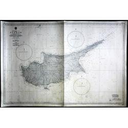
Cyprus
Large Admiralty sea chart of Cyprus.
Place & Date: London, 1964
Selling price: $60
Sold in 2017
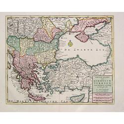
Nieuwe Kaart van Europisch Turkyen.
Izaak Tirion (d.1769) Amsterdam publisher. His Nieuwe en beknopte handatlas saw 6 editions between before 1740 and after 1784. Also Tegenwoordige staat van alle volkeren,...
Place & Date: Amsterdam, 1733.
Selling price: $225
Sold