Search Listings matching "cyprus" in Asia > Near / Middle East
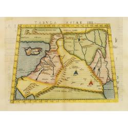
Tabula Asiae IIII.
Uncommon first edition of this classical map of the Holy Land, including Cyprus. The map is an enlarged version of Giacomo Gastaldi's published in 1548Girolamo Ruscelli's...
Place & Date: Venice, 1561
Selling price: $700
Sold in 2011
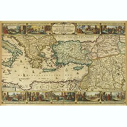
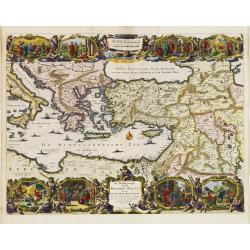
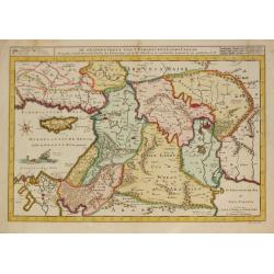
Syria, Cypern, Palestina, Mesopotamia, Babylonia, zwey Arabia mit Bergen, Waesseren und Stetten.
A famous woodblock map of the Near East, including Cyprus, Palestine, Iran, Iraq, etc. From his 'Cosmographia,' that great compendium of Renaissance knowledge. In 1588, n...
Place & Date: Basle, S.H. Petrie, 1588
Selling price: $110
Sold in 2014
![[Set of 5 maps of the Holy Land: Paradise, Canaan, Israel & Egypt, the Eastern Mediterranean. . .]](/uploads/cache/48407-250x250.jpg)
[Set of 5 maps of the Holy Land: Paradise, Canaan, Israel & Egypt, the Eastern Mediterranean. . .]
A lovely set of biblical maps of the Holy Land and its surrounds and, the Eastern Mediterranean by Cloppenburg, and engraved by Baptista Deuticum. The first map is an ear...
Place & Date: Amsterdam, ca 1590
Selling price: $1700
Sold in 2022
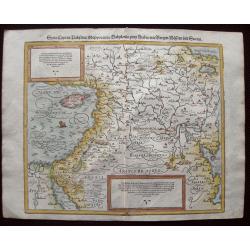
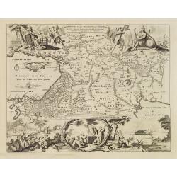
Primae Partis Asiae.
Includes the eastern part of the Mediterranean with Cyprus and Holy Land and the Black Sea with Turkey in between, the northern part of Egypt, Arabia Persia and Afghanist...
Place & Date: Antwerp 1593
Selling price: $1475
Sold
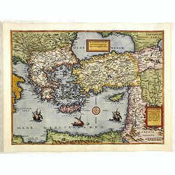
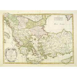
Natoliam Moderni dicunt tam partem quam Asiam minrem appelauere veteres. (with Cyprus).
Engraved by Van Deutecum, this is a spectacular example of the 1593 edition of the very rare De Jode's map of the Eastern Mediterranean and Asia Minor. It has two title c...
Place & Date: Antwerp, 1593
Selling price: $3900
Sold in 2014
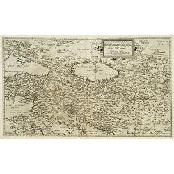
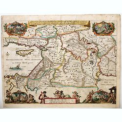
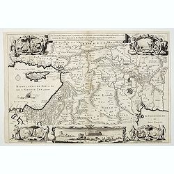
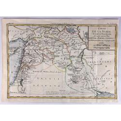
Mesopotamia Syrie.
This scarce map of the Eastern Mediterranean region extends throughout the Middle East and Egypt. Cyprus and the Levantine coasts are clearly detailed with particular att...
Place & Date: Hannover 1611
Selling price: $500
Sold
Geographische Beschryvinghe van de Wandeling der Apostelen ende De Reysen Pauli. . .
A decorative map of the eastern Mediterranean from Rome through Asia Minor and the Holy Land, depicting the route of Apostle Paul, including Italy, Sicily, Cyprus, Turkey...
Place & Date: Amsterdam, 1663
Selling price: $300
Sold in 2012
Nova Persiae Armeniae Natoliae et Arabiae.
Decorative map of Persia with Cyprus.
Place & Date: Amsterdam, 1670
Selling price: $500
Sold in 2010
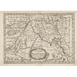
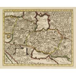
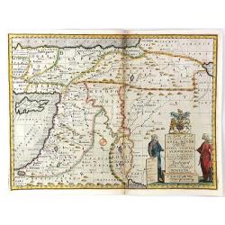
Syrien en Diarbeek verdeelt in hunne Scheidingen.
Engraved map of the Near East, including Cyprus, Palestine, Syria, Iraq, bordered by Greece, Turkey and Iran. The map shows great detail of towns, cities and topography, ...
Place & Date: Utrecht, 1680
Selling price: $70
Sold in 2016
De Beschrijvingh van de Reysen Pauli..
Decorative map with 8 insets depicting the wanders of Paulus and the Apostles. Dutch text on verso. Covers the territory from Sicily in the Mediterranean Sea to the Persi...
Place & Date: Amsterdam 1682
Selling price: $200
Sold
Beschryvinge van den Oorsprong der Volkeren, Uit de drie..
A very decorative map of the region from the Mediterranean through to the Persian Gulf, including Cyprus.The map depicts the Garden of Eden, Abraham's route from Ur, and ...
Place & Date: Amsterdam, 1687
Selling price: $170
Sold
Die Legend des tradition Paradiesis und des Landes Canaan. . .
A handsome late seventeenth century map of 'Earthly Paradise', comprising the Holy land and the Middle East. The map extends from modern-day southern Turkey and Cyprus, e...
Place & Date: Amsterdam, ca 1690
![[Globe gore of the Black Sea, with Russia, Georgia, Cyprus and Gulf of Bassora]](/uploads/cache/29159-250x250.jpg)
[Globe gore of the Black Sea, with Russia, Georgia, Cyprus and Gulf of Bassora]
Half-gore from his 110 centimetres in diameter globe of 1688 with Cyprus, part of Egypt, Saudi Arabia, Crimea, Russia including Ukraine and Moscow. Some of the half-gores...
Place & Date: Venice, 1696
Selling price: $1450
Sold in 2010
-250x250.JPG)
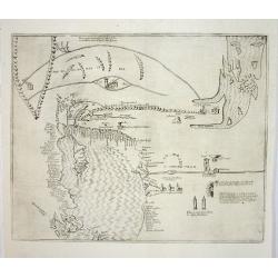
Aleppo
Very large 17th century copper engraving with a panoramic view of the city of Aleppo in Syria. The image is one of the largest of the former capital of Syria,showing th...
Place & Date: Amsterdam, 1698
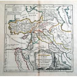
Persia sive Sophorum regnum cum Armenia Assyria Mesopotamia et Babylonia.
Uncommon map of the Near East, including Cyprus, Holy Land, Armenia, etc.
Place & Date: Amsterdam, 1700
Selling price: $30
Sold in 2008
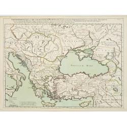
Theatrum Historicum.. Tu Imperii Romani.. Pars Orientalis..
Showing the Eastern part of the Roman Empire, extending from Greece and Cyprus to India and centered on Armenia and the Black and Caspian Seas. Prepared by G. de l'Isle, ...
Place & Date: Paris, 1705
Selling price: $200
Sold in 2009
A New Map of The Eastern Parts of Asia Minor. . .
A very pleasant map showing eastern Turkey, Cyprus, the Holy Land, Armenia, Lebanon, Syria, and Iraq. Map features a decorative title cartouche, and the heraldic arms of ...
Place & Date: Oxford, ca. 1712
Selling price: $55
Sold in 2018
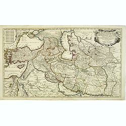
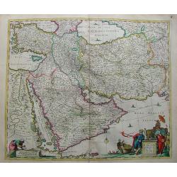
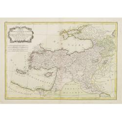
Regnum Persicum Imperium Turcicum in In Asia Russorum Provinciae ad Mare Caspium . . .
Striking map of the region bounded by Cyprus and the Eastern Mediterranean, the Nile, Medina, the Persian Gulf and the Indus River in the south and the Black Sea, Circass...
Place & Date: Amsterdam, 1720
Selling price: $400
Sold in 2012
Imperii Orientalis Circumjacenttium..Constantiono..
Including Greece, Cyprus, Ukraine, Moldavia and the Black Sea.
Place & Date: Paris, 1722
Selling price: $450
Sold in 2008
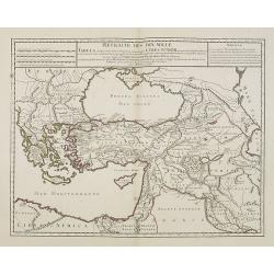
Retraite des Dix Mille Tabula conspectum exhibens Regionum omnium quas Cyrus Junior, Artaxerxi fratibellum illaturus ac Cyro in acie caeso. . .
Depicting ancient Turkey and Greece, including Cyprus, Black Sea, Iraq and Persia.
Place & Date: Paris, 1723
Selling price: $100
Sold in 2008
De Gelegentheyt van 't Paradys ende 't Land Canaan mitsgaders de eerste. . .
Daniel Stoopendaal's splendid map of the region between the Holy land and the Persian Gulf; takING in countries like Israel, Cyprus, Egypt, Lebanon, Palestine, Jordan, Sy...
Place & Date: Amsterdam, ca 1730
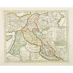
A New Map of the Eastern Parts of Asia Minor. Largely taken: As also of Syria, Armenia, Mesopotamia & c.
An interesting map of the Ottoman region from Eastern Turkey to the western shore of the Caspian Sea, and south to the Arabian Desert and Persian Gulf. Includes the moder...
Place & Date: London, 1738
Selling price: $36
Sold in 2016
Nieuwe kaart van Irak Arabi, Kurdistan, Diarbek. . .
Detailed map including the northern part of the Arabian peninsular, Palestine, Iraq, Iran and the eastern part of Cyprus.
Place & Date: Amsterdam, 1750
Selling price: $180
Sold in 2017
De Gelegenheyt van 't Paradys en 't Landt Canaan, mitsgaders d, eerste bewoonde landen der Patriarchen?door C.D./Albert Schut Schulp.
Dutch so-called ' Staten' bibles, published between 1637 and c. 1760, contained 5 maps: The World, 'Paradise', The Perigrinations, The Promised Land Canaan, The Travels o...
Place & Date: Amsterdam / Leiden, 1757
Selling price: $300
Sold
Turquie d'Europe et partie de celle d'Asie..
An attractive map of Turkey, Greece, Cyprus. Prepared by Janvier.
Place & Date: Paris, 1771
Selling price: $270
Sold in 2012
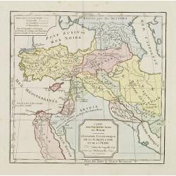
CARTE DES PREMIERS AGES DU MONDE
Beautiful ancient map, showing the eastern Mediterranean and the Near East. Includes parts of the present countries of Cyprus, Turkey, Russia, Black Sea, Caspian Sea, Arm...
Place & Date: Paris, 1780
Selling price: $50
Sold in 2014
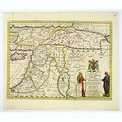
Carte de la Syrie et Autres Provinces Formant Aujourd'hui Partie de L'Empire Ottoman.
A fine map of Syria and other regions including; Roum, Irakarabia, Khosistan, Armemia, Kurdistan and Palestine. Also shown is most of the island of Cyprus. Louis Brion de...
Place & Date: Paris, 1780
Selling price: $52
Sold in 2020
Carte de la Turquie d'Asie..
Attractive map of the Near East centered on Turkey, ornated with a rococo title cartouche. A curious shape for Cyprus. Boundaries outlined in hand color.From theAtlas mod...
Place & Date: Paris ca 1783
Selling price: $135
Sold
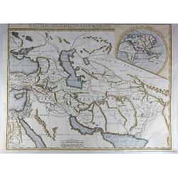
Partie Orientale de la Carte des Anciennes Monarchies.
This striking map depicts the eastern part of the Ancient World, including the Near East, Cyprus, Black Sea, Caspian Sea, Iran and Iraq. An inset map showing the eastern ...
Place & Date: Paris, ca 1800
Selling price: $45
Sold in 2017
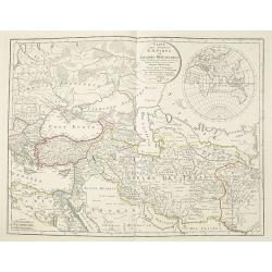
Cartes des premiers ages du monde. Géographie Ecclédiastique de la Turquie, d''Asie et de la Perse.
Map of ancient Turkey, Cyprus, Persia and Near and Middle East.By C. F. Delamarche, successor of Robert de Vaugondy, Geographer.
Place & Date: Paris, ca.1806
Selling price: $50
Sold
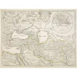
Carte des Anciens Empires et Grandes Monarchies pour l'Intelligence des Histoires ancienne et Romaine, de Rollin et autres auteurs. . .
Detailed copper-engraved map of the Near East, including Turkey, Cyprus, Iran, Irak, the Black and Caspian Sea. With a inset of the Eastern hemisphere, with a diameter of...
Place & Date: Paris, 1828
Selling price: $300
Sold in 2012
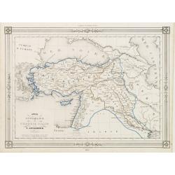
Asie Ottomane ou Turquie d'Asie..
Decorative map of Turkey and Cyprus, prepared by J.G.Barbié du Bocage.Engraved by Ch.Smith, published by Basset who was established in Paris, rue de Seine 33. From atlas...
Place & Date: Paris, 1846
Selling price: $40
Sold in 2009
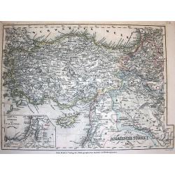
Die Asiatische Türkey 1854.
A superbly steel-engraved map from the rare German Atlas: Meyer's Zeitungs-Atlas, considered to be the finest German Atlas of the mid 19th century! Revised edition for th...
Place & Date: Hildburghausen, 1857
Selling price: $20
Sold