Search Listings matching "cyprus" in Asia
![[Holy Land, Cyprus]](/uploads/cache/84451-250x250.jpg)
[Holy Land, Cyprus]
Attractive colored woodcut map showing the Holy Land with Cyprus. With a ship and a sea monster. From a Latin edition of Cosmographia by Sebastian Munster.
Place & Date: Petri, Basle, 1550 ca.
Selling price: $175
Sold in 2020
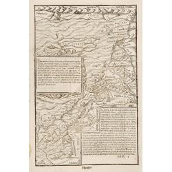
Prima Asiae Tabula.
Copperplate printed map of Turkey and including Cyprus from the "Atlas In Hoc Operae Haec Continetur…" printed by Bernardinus Venetus de Vitalibus. The map sh...
Place & Date: Rome, 1478 or 1490
Selling price: $3500
Sold
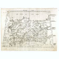
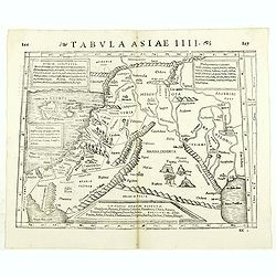
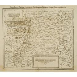
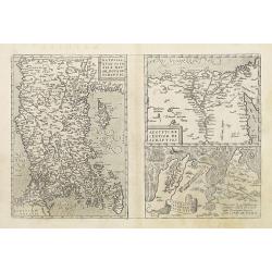
Tabula Quarta Asia (Holy Land and Cyprus)
One of the earliest maps available to a collector of Cyprus, Syria, Mesopotamia,. Babylonia, Arabia Petraea, Armenia Minor and the Holy Land, based upon the Georgraphy of...
Place & Date: Strasburg, 1525
Selling price: $2000
Sold in 2015
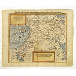
![Tabula IIII Asiae. [Holy Land, Syria, Cyprus, Arabia.]](/uploads/cache/26877-250x250.jpg)
Tabula IIII Asiae. [Holy Land, Syria, Cyprus, Arabia.]
One of the earliest maps available to a collector of Cyprus, Syria, Mesopotamia,. Babylonia, Arabia Petraea, Armenia Minor and the Holy Land, based upon the Georgraphy of...
Place & Date: Strassburg, 1535
Selling price: $1550
Sold in 2011
Cyria / Cypern / Palestina / Mesopotamia / Babylonia / Chaldea und zwey Arabia mit Bergen Wassern und Stetten.
An early, attractive woodcut map of the eastern Mediterranean and the Middle East. Covering the area between northern Syria and the Red Sea, with Cyprus, the Holy Land, J...
Place & Date: Basel, ca 1540
Selling price: $190
Sold in 2021
![Von den Laendern Asie [Palestine]](/uploads/cache/18623-250x250.jpg)
Von den Laendern Asie [Palestine]
Sebastian Münster, 1489-1552, outstanding geographer of Basle. Editied Ptolemy's atlas ' Geographia Universalis', editions 1540,-42, -45, -51 and -52. Published his &quo...
Place & Date: Basle, 1550
Selling price: $200
Sold
-250x250.JPG)
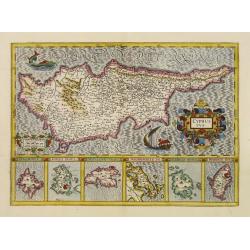
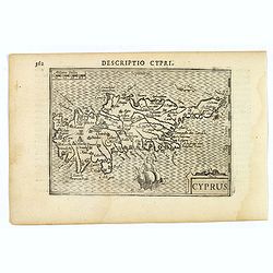
Cyprus, L'Isle de Cypre
Antique woodcut map of Cyprus by Sebastian Münster, [In letter-text above the map:] L'isle de Cypre.Probably the oldest obtainable map showing Cyprus only.On the back...
Place & Date: BASEL, ca 1550
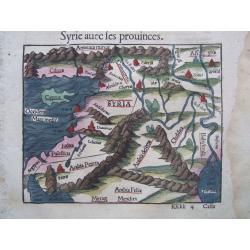
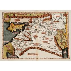
Cyprus/Near East, & text on Cyprus. - Syrie avec les prouinces
Antique woodcut map of Cyprus + the Near East by Sebastian Münster, [In letter-text above the map:] Syrie avec les prouinces. Together one more text sheet on Cyprus ['...
Place & Date: BASEL, ca 1550
![[Lot of 2 plates] Ierusalem civitas../ [map of Palestine + Cyprus].](/uploads/cache/48240-250x250.jpg)
[Lot of 2 plates] Ierusalem civitas../ [map of Palestine + Cyprus].
Early woodcut view of the city of Jerusalem surrounded by its ancient walls, featuring the temples and mosques. From the 1552 Latin text edition of Munster's Cosmographia...
Place & Date: Basel, 1552
Selling price: $100
Sold in 2023
![[Lot of 2 leaves with map of Cyprus]](/uploads/cache/48277-250x250.jpg)
[Lot of 2 leaves with map of Cyprus]
Two printed text leaves relating to Cyprus with a map (10 x 15 cm). From the 1552 Latin text edition of Münster's Cosmographia, which is a short and complete summary of ...
Place & Date: Basel, 1552
Selling price: $58
Sold in 2022
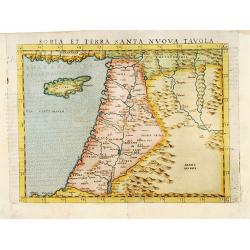
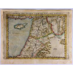
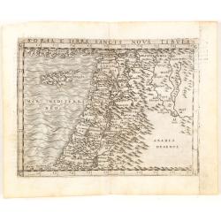
Soria et Terra Santa nova tavola.
Uncommon first edition of this classical map of the Holy Land, including Cyprus. The map is an enlarged version of Giacomo Gastaldi's published in 1548Girolamo Ruscelli's...
Place & Date: Venice, 1561
Selling price: $400
Sold in 2016
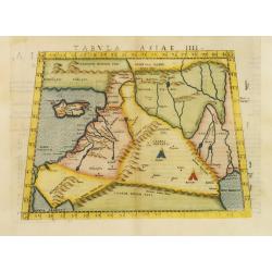
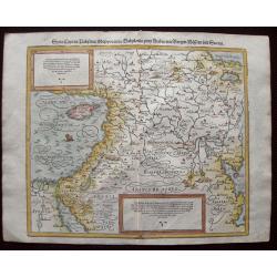
Tabula Asiae IIII.
Uncommon first edition of this classical map of the Holy Land, including Cyprus. The map is an enlarged version of Giacomo Gastaldi's published in 1548Girolamo Ruscelli's...
Place & Date: Venice, 1561
Selling price: $700
Sold in 2011
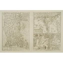
![Sinus Persicus [Arabia]](/uploads/cache/39586-250x250.jpg)
Sinus Persicus [Arabia]
Rare wood block printed map of the Holy Land, Syria, Cyprus, northern Arabia from "De orbis situ libri tres accuratissime emendati". Underneath the map a letter...
Place & Date: Basle, Henri Petri, 1564
Selling price: $150
Sold in 2017
![[Tevarya] Lago di Tiberia.](/uploads/cache/16894-250x250.jpg)
[Tevarya] Lago di Tiberia.
Extremely rare map centered on the town and Lake Tevarya, including Jerusalem, Bethlehem, Sichem, Damascus and the island of Cyprus.Engraved by Paolo Furlani (active 1561...
Place & Date: Venice 1568
Selling price: $1925
Sold
![[Tevarya] Lago di Tiberia.](/uploads/cache/22050-250x250.jpg)
[Tevarya] Lago di Tiberia.
Extremely rare map centered on the town and Lake Tevarya, including Jerusalem, Bethlehem, Sichem, Damascus and the island of Cyprus.Engraved by Paolo Furlani (active 1561...
Place & Date: Venice 1568
Selling price: $1750
Sold
Tabula Asiae IIII. ( Holy Land, Cyprus, Syria, etc.)
Double-page woodcut Ptolemaic-style map by Sebastian Münster figuring Holy Land, Cyprus, Syria, etc., published in the edition of Strabo by Henri Petri in 1571."Str...
Place & Date: Basle, Henri Petri, 1571
Selling price: $75
Sold in 2018
![[Cyprus].](/uploads/cache/41984-250x250.jpg)
[Cyprus].
Woodcut Ptolemaic-style map by Sebastian Münster figuring Cyprus, published in the edition of Strabo by Henri Petri in 1571."Strabonis rerum geographicarum" is...
Place & Date: Basle, Henri Petri, 1571
Selling price: $180
Sold in 2018
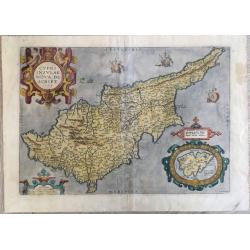
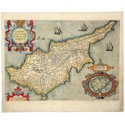
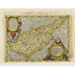
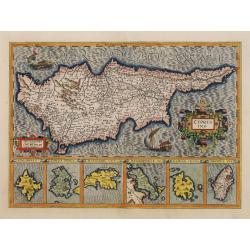
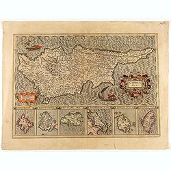
Cypri insulae nova descript.
A milestone in the history of cartography of Cyprus, based on a 1570 map by Giacomo Franco. The map is embellished by sailing ships and a sea monster, bearing a map of Le...
Place & Date: Antwerp, 1573
Selling price: $1200
Sold in 2020
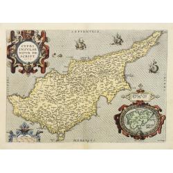
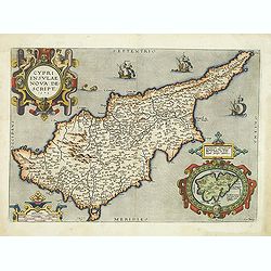
Cypri Insulae Nova descript. 1573.
This is a beautiful copy of a classic map of Cyprus. It is the earliest obtainable version of the best map of Cyprus made to date. Ortelius based his map upon that publis...
Place & Date: Antwerp, 1574
Selling price: $2700
Sold in 2011
![[Asia Minor]](/uploads/cache/35967-250x250.jpg)
[Asia Minor]
Early, attractive hand-colored woodcut map of Turkey, with an unnamed Cyprus in the lower right corner. From the German edition of Sebastian Münster's Cosmography, title...
Place & Date: Basle, ca. 1574
Selling price: $140
Sold in 2016
Soria et Terra Santa Nuova Tavola.
Ruscelli's map of the Holy Land, Syria and Cyprus. One of the earliest obtainable separately published maps of the region. The map first appeared in the 1561 edition of R...
Place & Date: Venice, 1574
Selling price: $290
Sold in 2017
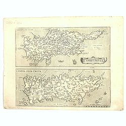
Cyprus Insula / Candia, Olim Creta.
Two maps on one sheet. Copper engraving illustrating Cyprus and Crete, with Latin text on verso. From 1584 onwards editions of the Ortelius atlas no longer included this ...
Place & Date: Antwerp, 1575
Holy Land. Die Tafel gibt ein klein anzeigung...
Early, attractive woodcut map of the Holy Land with Cyprus. On the full page. From the German edition of Sebastian Münster's Cosmography, titled Cosmographey oder beschr...
Place & Date: Basel, 1578
Selling price: $150
Sold in 2020
No title (Holy Land)
Attractive full page longitudinal map of Palestine, Syria and Cyprus, cut by Hans Rudolf Manuel Deutsch. The shore line running from Southern Anatolia to the Nile Delta. ...
Place & Date: Basle 1550-1580
Selling price: $220
Sold
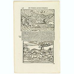
![[Cyprus]](/uploads/cache/26211-250x250.jpg)
[Cyprus]
Two woodcuts on one page. In upper part a map of Cyprus, in lower part a jumping deer and a sheep drinking water. The drinking sheep with old pen scratches. From his Cosm...
Place & Date: Basle, 1550-1580
Selling price: $185
Sold in 2008
![[Map of the Holy Land, including Cyprus]](/uploads/cache/26213-250x250.jpg)
[Map of the Holy Land, including Cyprus]
Attractive full page longitudinal map of Palestine, Syria and Cyprus, cut by Hans Rudolf Manuel Deutsch. The shore line running from Southern Anatolia to the Nile Delta. ...
Place & Date: Basle 1550-1580
Selling price: $70
Sold in 2008
![[Cyprus]](/uploads/cache/92347-250x250.jpg)
[Cyprus]
Very early map of Cyprus, by Sebastian Münster from his Cosmographia. On a full sheet with text on both sides in German, and a print of deer.
Place & Date: Basel, 1550-1580
Selling price: $80
Sold in 2013
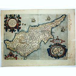
Cypri Insulae Nova descript. 1573.
This is a beautiful copy of a classic map of Cyprus. It is the earliest obtainable version of the best map of Cyprus made to date. Ortelius based his map upon that publis...
Place & Date: Antwerp, 1581
Selling price: $800
Sold in 2014
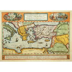
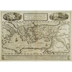
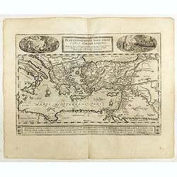
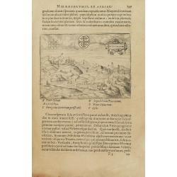
Peregrinatio Divi Pauli Typus Corographicus.
"A splendid map depicting the travels of Paulus. With two fine scenes in top. Showing the countries along the Mediterranean, including Cyprus and Italy. A first edit...
Place & Date: Antwerp 1584
Selling price: $850
Sold
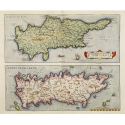
Cyprus Insula / Candia, Olim Creta.
Two maps on one sheet. Copper engraving illustrating Cyprus and Crete, with Latin text on verso. From 1584 onwards editions of the Ortelius atlas no longer included this ...
Place & Date: Antwerp, 1570-1584
Selling price: $1800
Sold in 2008
CYPRI INSULAE NOVA DE SCRIPT 1573 - LEMNOS INSULAE.
A striking, old colored example of this important early map of Cyprus from Ortelius' Theatrum Orbis Terrarum, the first modern atlas of the world. Large inset of Lemnos. ...
Place & Date: Antwerp, 1584
Selling price: $700
Sold in 2019
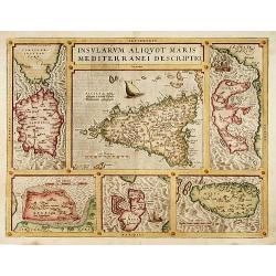
Insularum Aliquot Maris Mediterranei Descriptio.
The decorative composite map of six Mediterranean islands. The larger Sicily map is surrounded by maps of Sardinia, Corfu, Zerbi, Elba, and Malta. Each map is well detail...
Place & Date: Antwerp, 1587
Selling price: $800
Sold
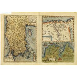
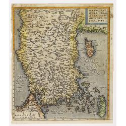
Natoliae Quae Olim Asia Minor, Nova de Scriptio / Carthaginis Celeberrimi Sinus Typus / Aegypti re Centior de Scriptio
Three detailed regional maps by Ortelius, from his Theatrum Orbis Terrarum, the first modern atlas of the world.The first map covers Asia Minor, Cyprus and the Eastern Me...
Place & Date: Antwerp, 1587
Selling price: $210
Sold in 2012
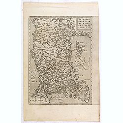
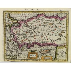
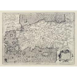
Natoliae Quae Olim Asia Minor, Nova de Scriptio.
Detailed map of Turkey, including Cyprus by Abraham Ortelius, from his "Theatrum Orbis Terrarum", the first modern atlas of the world.East to the top. Latin tex...
Place & Date: Antwerp, 1587
Selling price: $300
Sold in 2015
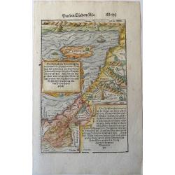
Syria, Cypern, Palestina, Mesopotamia..
A famous wood block map of the Near East, including Cyprus, Palestine, Iran and Iraq, etc. From his Cosmographia , that great compendium of Renaissance knowledge. In 1588...
Place & Date: Basle c.1588
Selling price: $210
Sold
Syria / Cypern / Palestina Mesopotamia / Babylonia / zwen Arabia / mit Bergen / Wasseren und Stetten.
A famous wood block map of the Near East, including Cyprus, Palestine, Iran and Iraq, etc. From his "Cosmographia", that great compendium of Renaissance knowled...
Place & Date: Basle, c.1588
Selling price: $200
Sold in 2012
Syria, Cypern, Palestina, Mesopotamia, Babylonia, zwey Arabia mit Bergen, Waesseren und Stetten.
A famous woodblock map of the Near East, including Cyprus, Palestine, Iran, Iraq, etc. From his 'Cosmographia,' that great compendium of Renaissance knowledge. In 1588, n...
Place & Date: Basle, S.H. Petrie, 1588
Selling price: $110
Sold in 2014
Natoliae..Aegypti recentior..Carthaginis (3 maps on 1 sheet)
3 Maps on one sheet. Map to the left east to the top. Detailed map Turkey, including Cyprus and Crete. Also map of the Nile delta and another map of Tunis.
Place & Date: Antwerp 1590
Selling price: $310
Sold
Natoliae..Aegypti Recentior..Carthaginis.. (3 maps on 1 sheet)
3 Maps on one sheet. Map to the left east to the top. Detailed map Turkey, including Cyprus and Crete. Also map of the Nile delta and another map of Tunis.
Place & Date: Antwerp 1590
Selling price: $325
Sold
Cyprus.
Two woodcuts on one page. In upper part a map of Cyprus, in lower part a jumping deer and a sheep drinking water. The drinking sheep with old pen scratches. . From a Lati...
Place & Date: Basle, 1550-1590
Selling price: $120
Sold in 2012
![In monte casio iuxta ostracinam. . . [Israel with Cyprus]](/uploads/cache/32575-250x250.jpg)
In monte casio iuxta ostracinam. . . [Israel with Cyprus]
On recto a woodcut engraved map of Israel and Cyprus. Engraved by Hans Rudolf Manuel Deutsch, with his monogram. From a Latin text edition of his Geographia , that great ...
Place & Date: Basle, 1550-1590
Selling price: $20
Sold in 2015
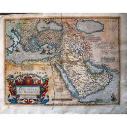
Turcici Imperii Descriptio.
The most famous of all the sixteenth-century maps of the Middle East. It extends from Greece to Arabia and covers the Cradle of Civilisation region. The Eastern Mediterra...
Place & Date: Antwerp, ca 1590
Selling price: $900
Sold in 2016
![[Set of 5 maps of the Holy Land: Paradise, Canaan, Israel & Egypt, the Eastern Mediterranean. . .]](/uploads/cache/48407-250x250.jpg)
[Set of 5 maps of the Holy Land: Paradise, Canaan, Israel & Egypt, the Eastern Mediterranean. . .]
A lovely set of biblical maps of the Holy Land and its surrounds and, the Eastern Mediterranean by Cloppenburg, and engraved by Baptista Deuticum. The first map is an ear...
Place & Date: Amsterdam, ca 1590
Selling price: $1700
Sold in 2022
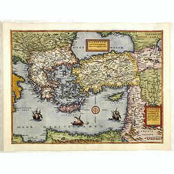
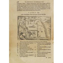
Primae Partis Asiae.
Includes the eastern part of the Mediterranean with Cyprus and Holy Land and the Black Sea with Turkey in between, the northern part of Egypt, Arabia Persia and Afghanist...
Place & Date: Antwerp 1593
Selling price: $1475
Sold
Natoliam Moderni dicunt tam partem quam Asiam minrem appelauere veteres. (with Cyprus).
Engraved by Van Deutecum, this is a spectacular example of the 1593 edition of the very rare De Jode's map of the Eastern Mediterranean and Asia Minor. It has two title c...
Place & Date: Antwerp, 1593
Selling price: $3900
Sold in 2014
![Primae Partis Asiae accurata delineatio... [shows Cyprus]](/uploads/cache/97442-250x250.jpg)
Primae Partis Asiae accurata delineatio... [shows Cyprus]
Engraved by the van Deutecum brothers, based upon an earlier map by Gastaldi.0De Jode's rare map of the region, bounded by the Black Sea and Mediterranean in the West, an...
Place & Date: Antwerp, 1593
Selling price: $1250
Sold in 2017
Peregrinationis Divi Pauli Typus?
A splendid map depicting the travels of Paulus. With two fine scenes in top. Showing the countries along the Mediterranean, including Cyprus and Italy. Based on Mercator'...
Place & Date: Antwerp 1595
Selling price: $650
Sold in 2008
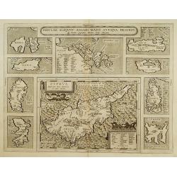
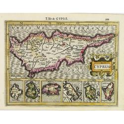
Insular. Aliquot Aegaei Maris Antiqua Descrip.
Ten maps on one plate. Showing Rinia and Dilos, Nicaria, Euboea, Samos, Keos (near Euboea), Rhodus, Chios, Cyprus, Lesbos, Lemnos.This map belongs to a series of historic...
Place & Date: Antwerp 1595
Selling price: $600
Sold
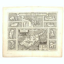
Cyprus - Insular Aliquot Aegaei maris antiqua descrip.
Ten maps on one sheet. With large map of Cyprus. Provenance: This map is from the personal collection of dr. Marcel van den Broecke, author of Ortelius Atlas Maps An...
Place & Date: Antwerp, 1595
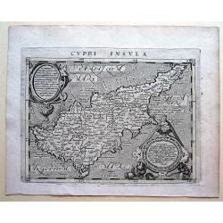
Cypri Insvla.
Lovely copper engraved map of the island of Cyprus featuring two large cartouches and fancy lettering in the seas. Good detail in the interior.The map comes from a scarce...
Place & Date: Cologne 1597
Selling price: $730
Sold
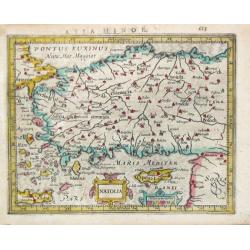
Natoliae quae olim Asia minor.
East to the top. Detailed map Turkey, including Cyprus and Crete. German text on verso.
Place & Date: Antwerp, 1598
Selling price: $160
Sold in 2010
Cypri Insulae Nova descript. 1573.
This is a beautiful copy of a classic map of Cyprus. It is the earliest obtainable version of the best map of Cyprus made to date. Ortelius based his map upon that publis...
Place & Date: Antwerp, 1598
Selling price: $2000
Sold in 2012
Soria et Terra Santa nuova tavola.
Early map of this classical map of the Holy Land, including Cyprus, prepared by Giovanni Botero. The copper plate was however later used by Giuseppe Rosaccio's expended e...
Place & Date: Venice, 1598
Selling price: $200
Sold in 2014
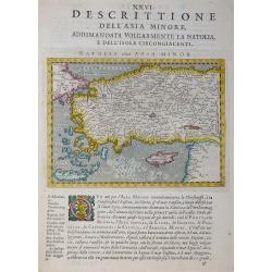
Desrittione Dell'Asia Minore addimandata volgarmente La Natolia e dell'Isole circongiacenti.
Map shows Turkey, Cyprus and Greek Islands along Turkish coast south to the Island of Crete (Candia) and the Syrian coast. Verso: related text.ublished in “Geografia ci...
Place & Date: Venice, 1598
Selling price: $100
Sold in 2017
Natoliae quae olim Asia minor.
East to the top. Detailed map Turkey, including Cyprus and Crete.
Place & Date: Antwerp, 1598
Selling price: $50
Sold in 2015
Peregrinationis Divi Pauli Typus..
A splendid map depicting the travels of Paulus. With two fine scenes in top. Showing the countries along the Mediterranean, including Cyprus and Italy. A first edition wi...
Place & Date: Antwerp, 1598
Selling price: $400
Sold in 2022
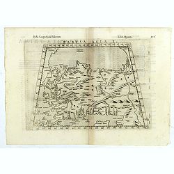
Tabula Asiae I.
The third state of Ruscelli's map of Turkey, based upon Claudius Ptolemy. Showing Asia Minor and parts of the Black Sea and Cyprus. Girolamo Ruscelli first published the ...
Place & Date: Venice, 1598
Selling price: $85
Sold in 2018
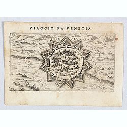
![Cipro [Map of Cyprus]](/uploads/cache/45237-250x250.jpg)
Cipro [Map of Cyprus]
Very rare map of Cyprus Island published in the first edition of "Viaggio da Venetia, a Costantinopoli. Per Mare, e per Terra, & infieme quello di Terra Santa. D...
Place & Date: Venice, Giacomo Franco, 1598
Selling price: $625
Sold in 2020
Nicosia.
Very rare view of Nicosia, also known as Lefkosia, which is the divided capital city of Cyprus. Published in the first edition of "Viaggio da Venetia, a Costantinopo...
Place & Date: Venice, Giacomo Franco, 1598
Selling price: $850
Sold in 2020
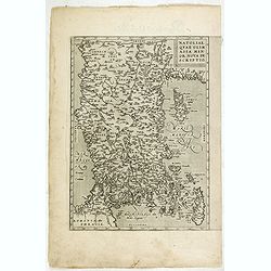
![Natolia Olim Sive Asia Minor. [shows Cyprus]](/uploads/cache/35957-250x250.jpg)
Natolia Olim Sive Asia Minor. [shows Cyprus]
A nice example of Mathias Quad's map of Asia Minor and Cyprus. Latin text beneath and to verso of map. A good early map of the region in good condition. Engraved by Johan...
Place & Date: Cologne, 1600
Selling price: $230
Sold in 2015
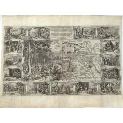
Tabula Geographica, in Qua Paradisus, nec Non Regiones, Urbes oppida, et loca describuntur; quorum in Genesi mentio fit.
A wonderful work of art, consisting of a map of the Holy Land and contiguous regions, including Cyprus and Armenia, surrounded by beautiful etchings. In the center of the...
Place & Date: Amsterdam, 1604
Selling price: $1350
Sold in 2021
CYPRUS INS:
A decorative map of Cyprus, with insets for the other six islands.
Place & Date: Amsterdam 1606
Selling price: $800
Sold
CYPRUS INS:
A decorative map of Cyprus, with insets for the other six islands.
Place & Date: Amsterdam 1606
Selling price: $1000
Sold
![Natoliae Sive Asia Minor. [with Cyprus]](/uploads/cache/10497-250x250.jpg)
Natoliae Sive Asia Minor. [with Cyprus]
Mercator's map of Turkey, Asia Minor and Cyprus., published by Jodocus Hondius. Fine dark impression, including decorative cartouches, sailing ship, sea monster and finel...
Place & Date: Amsterdam, 1606
Selling price: $750
Sold in 2011
Cyprus.
A decorative miniature map of the eastern Mediterranean island of Cyprus, published by Petrus Bertius in Amsterdam, at the beginning of the seventeenth century. This attr...
Place & Date: Amsterdam, 1606
Selling price: $150
Sold in 2019
CYPRUS INS:
A decorative map of Cyprus, with insets for the other six islands.
Place & Date: Amsterdam, 1606
Selling price: $435
Sold in 2020
Natolia.
Early map of Turkey, including Cyprus, from the first French-text edition of Jodocus Hondius' Atlas Minor.Shortly after the publication of the big folio-atlases the need ...
Place & Date: Amsterdam, 1608
Selling price: $300
Sold in 2011
Cyprus, Rhodus. . .
Early map of Cyprus with inset maps of Rhodes, Cerigo, Negroponte, Mytilene, Kéos and Stalimene at the bottom.From the first French-text edition of Jodocus Hondius' Atla...
Place & Date: Amsterdam, 1608
Selling price: $400
Sold in 2008
![Natoliae Sive Asia Minor. [with Cyprus]](/uploads/cache/02938-250x250.jpg)
Natoliae Sive Asia Minor. [with Cyprus]
Decorative map of present day Turkey with Cyprus prominently shown. The sea is boldly engraved in a wave pattern. There is a large sea monster in the Mediterranean and an...
Place & Date: Amsterdam, 1610
Selling price: $700
Sold in 2013
Natoliae Sive Asia Minor.
Map of Turkey, also depicting Cyprus.
Place & Date: Amsterdam, 1610
Selling price: $230
Sold
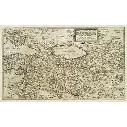
Mesopotamia Syrie.
This scarce map of the Eastern Mediterranean region extends throughout the Middle East and Egypt. Cyprus and the Levantine coasts are clearly detailed with particular att...
Place & Date: Hannover 1611
Selling price: $500
Sold
Cypri Insula.
An attractive copper engraved map of Cyprus by Magini (1555-1617) from Geographiae, tum veteris, tum novae, volumina duo., published by Johannes Jansson. Overall size: 17...
Place & Date: Arnhem, 1617
Selling price: $120
Sold in 2018
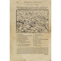
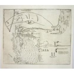
Varia antiquitates in itinere Bethleëmitico confpecta. . .
Text page with copper engraved illustration of region north of Jerusalem taken from Itinerarium Hierosolymitanum et Syriacum, in quo variarum Gentium Mores et Institua in...
Place & Date: Antwerp, Verdussen, 1619
Selling price: $30
Sold in 2009
Hiervsalem.
Text page with copper engraved illustration of Jerusalem, with in background Mount Olive, taken from Itinerarium Hierosolymitanum et Syriacum, in quo variarum Gentium Mor...
Place & Date: Antwerp, Verdussen, 1619
Selling price: $30
Sold in 2009
![Hiervsalem. [Jerusalem]](/uploads/cache/25500-250x250.jpg)
Hiervsalem. [Jerusalem]
Text page with copper engraved illustration of Jerusalem, taken from Itinerarium Hierosolymitanum et Syriacum, in quo variarum Gentium Mores et Institua insularum, region...
Place & Date: Antwerp, Verdussen, 1619
Selling price: $50
Sold in 2008
Hiervsalem.
Text page with copper engraved plan of Jerusalem, taken from Itinerarium Hierosolymitanum et Syriacum, in quo variarum Gentium Mores et Institua insularum, regionum, vrbi...
Place & Date: Antwerp, Verdussen, 1619
Selling price: $50
Sold in 2008
![Ramma. [Ramla] / Domus Boni Latronis [Latrum]](/uploads/cache/25502-250x250.jpg)
Ramma. [Ramla] / Domus Boni Latronis [Latrum]
Text page with copper engraved view of Ramla, taken from Itinerarium Hierosolymitanum et Syriacum, in quo variarum Gentium Mores et Institua insularum, regionum, vrbium s...
Place & Date: Antwerp, Verdussen, 1619
Selling price: $30
Sold in 2009
![Cipro [ Cyprus ]](/uploads/cache/14409-250x250.jpg)
Cipro [ Cyprus ]
One of the earliest separate maps of Cyprus. Includes decorative cartouche, sea monsters. Nice wide margin example, with Italian text. A decorative compass rose lies in l...
Place & Date: Padova, (1572-) 1620
Selling price: $850
Sold
Natolia.
Jodocus Hondius published the first edition of the pocket atlas ' Atlas Minor' in 1607, it was followed by many editions in Dutch, Latin, German and French till 1651.An a...
Place & Date: Amsterdam, c. 1620
Selling price: $115
Sold
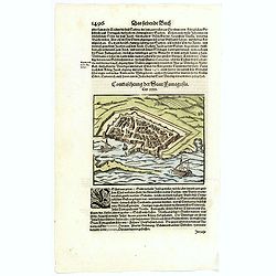
Contrafehtung der Statt Famagusta.
Munster's small, but delightful town plan of the Cypriot city of Famagusta, based largely on the view of the city by Braun & Hogenberg of 1572. Published in Munster's...
Place & Date: Basle, ca 1620
Selling price: $91
Sold in 2020