Browse Listings in World Maps
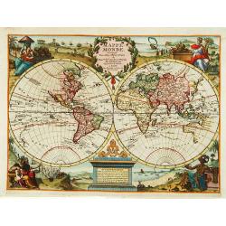
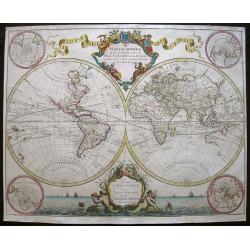
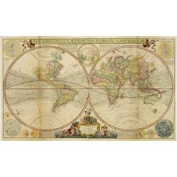
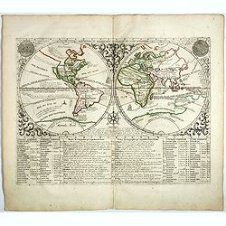
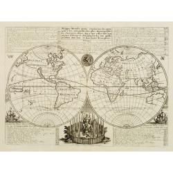
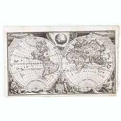
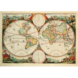
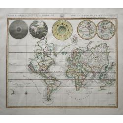
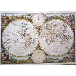
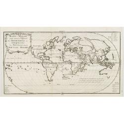
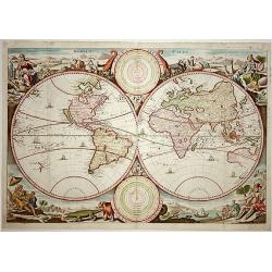
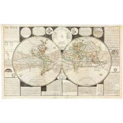
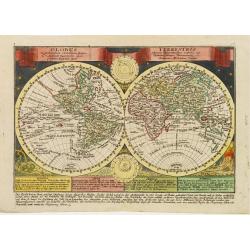
Mappe Monde.
Decorative world map in two hemispheres. Vignettes symbolising the four continents occupy the corners: between the hemispheres there are two elaborate cartouches.
Place & Date: Leiden 1720
Selling price: $1225
Sold
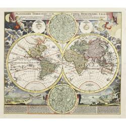
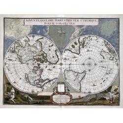
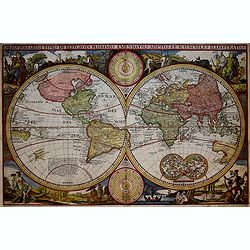
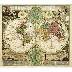
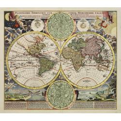
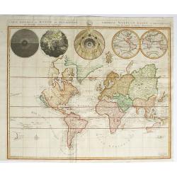
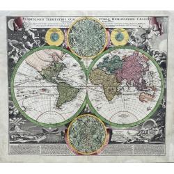
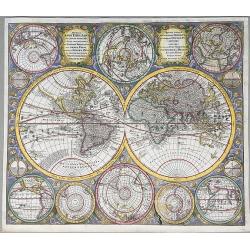
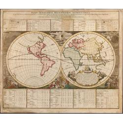
Planiglobii Terrestris Cum Utroq Hemisphaerio.
This is one of the most decorative eighteenth century world maps, surrounded by vivid engravings of natural phenomena such as waterspouts, a rainbow, earthquakes, and a v...
Place & Date: Nuremberg, ca. 1720
Selling price: $2700
Sold
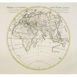
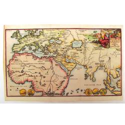
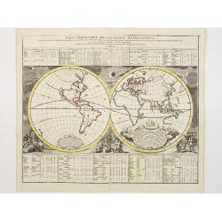
Orbis Veteribus Noti Tabula Nova.
Map of the Eastern Hemisphere, including Australia, with the tip of Diemensland. Japan's Honshu is called Satyrorum , and Kyushu Insulae Tres.The map is most interesting ...
Place & Date: Amsterdam, 1720
Selling price: $100
Sold in 2017
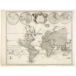
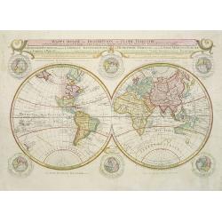
Planisphaerium Terrestre../ Vlakke Aard-kloot..
Interesting and detailed world map, cartographically up-to-date and showing the routes of explorers, including Magellan, Dampier, Tasman, Gaetani and Chaumont. Nova Brita...
Place & Date: Amsterdam, 1700 - ca.1720
Selling price: $2600
Sold in 2011
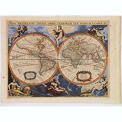
Nova Delineatio Totius Orbis Terrarum Per Petrum Vander Aa.
Originally engraved by Jacob van Meurs in 1660, and reissued here by Vander Aa, this map is based on Arnold Colom's wonderfully graphic map from the first world maritime ...
Place & Date: Leiden, 1720
Selling price: $900
Sold in 2013
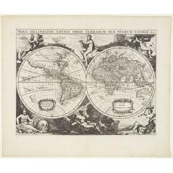
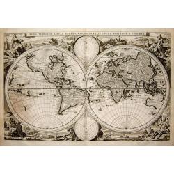
Nova delineatio Orbis Terrarum..
Very decorative with double hemispheres surrounded by six figures representing earth, fire, water, day, and night. It Shows California as an island. Based on Colom's rare...
Place & Date: Leiden, 1720
Selling price: $875
Sold in 2013
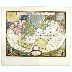
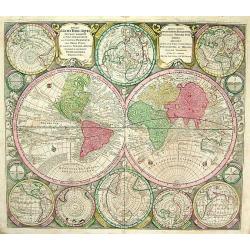
Novus Planiglobii Terrestris per Utrumque polum conspectus.
Until recently it was believed that the Blaeu establishment produced only two world maps for its atlases -the rectangular map of 1606 and the double hemisphere of 1662. H...
Place & Date: Amsterdam, 1720
Selling price: $4000
Sold
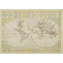
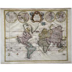
Mappe-Monde dressé sur les observations de.. par M.de L'Isle
Guillaume de L'Isle was one of the first, in his world map, to correct the extended length of the Mediterranean, and to give back to California its true peninsular format...
Place & Date: Amsterdam, 1720
Selling price: $450
Sold in 2016
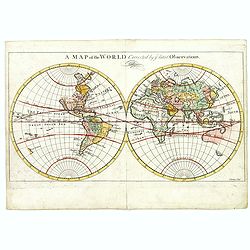
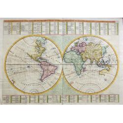
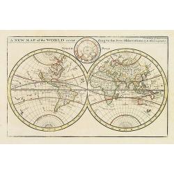
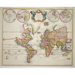
A map of the World, corrected by the latest Observations.
Map in two hemispheres, most likely after Herman Moll's "A map of the world on wch. is delineated the voyages of Robinson Curso." London, 1719 and probably prin...
Place & Date: London, ca. 1720
Selling price: $95
Sold in 2017
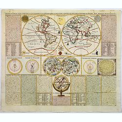
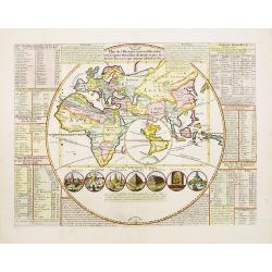
Nouvelle Carte pour conduire a l'Astronomie et a la Geographie. . .
A very decorative double hemisphere map of the world, surrounded by various astronomical models. The models surrounding the earth include a solar system, Kirchers's model...
Place & Date: Amsterdam, ca 1720
Selling price: $325
Sold in 2018
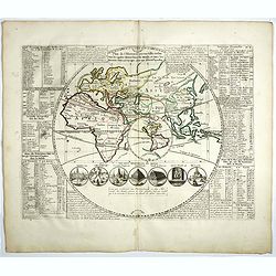
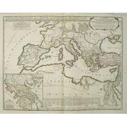
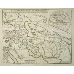
Plan de l'Histoire Universelle où l'on voit les quatre monarchies du Monde . . ..
Eastern hemisphere in a circle, into which is inset a smaller Western Hemisphere with the island of California. The map shows the extents of the Roman Empire and Alexande...
Place & Date: Amsterdam, 1720
Selling price: $210
Sold in 2023
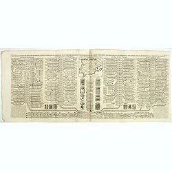
Carte généalogique des rois de Navarre de Castille d'Arragon de Portugal et de Grenade, rangée en parallele avec la carte d'Espagne qui distingue les diverses situations de leurs états, leurs armes et alliances.
Interesting sheet with a small map of Spain and Portugal and a genealogical tree of the kings of Castile and Navarre, with descriptive French text, from Chatelain's monum...
Place & Date: Amsterdam, 1720
Selling price: $60
Sold in 2020
-250x250.jpg)
Orbis Terrarum
Dutch so-called ' Staten' bibles, published between 1637 and c. 1760, contained 5 maps: The World, ' Paradise', The Perigrinations, The Promised Land Canaan, The Travels ...
Place & Date: Amsterdam, c. 1720
Selling price: $1500
Sold in 2022
Novus Planiglobii Terrestris per Utrumque polum conspectus.
In the last years of his life, Joan Blaeu commissioned a double hemisphere world map, based on the unusual polar projection. Probably, the terrible fire of February 22, 1...
Place & Date: Amsterdam, 1720
Selling price: $3900
Sold in 2023
Nouvaux Mappemonde ou globe terrestre avec des tables et des ..
This impressive double hemisphere is a wonderful example of Chatelain?s elegant maps. Included in the 1721 edition of Atlas Historique, published by Chatelain in Amsterda...
Place & Date: Amsterdam 1721
Selling price: $600
Sold
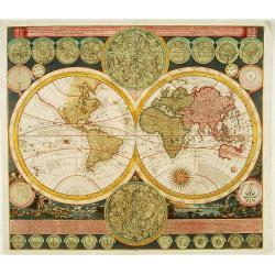
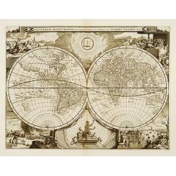
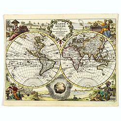
NOUVEAUX MAPPEMONDE OU GLOBE TERRESTRE AVEC DES TABLES ET DES REMARQUES POUR CONDUIRE A LA CONNOISSANCE DE LA GEOGRAPHIE ET DE L'HISTOIRE.
An impressive double hemisphere world map that is a beautiful example of Chatelain's elegant maps. From the 1721 edition of Atlas Historique, published by Chatelain in Am...
Place & Date: Amsterdam, 1721
Selling price: $1000
Sold in 2019
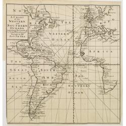
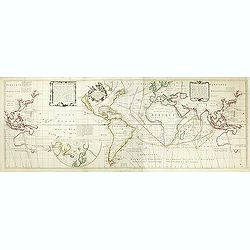
A Chart of the Western and Southern Oceans.
Copper engraved chart of the Atlantic showing the eastern part of North America, all of South America, and most of Europe and Africa. The tract of the voyage of John Narb...
Place & Date: Amsterdam 1722
Selling price: $65
Sold
A new and correct map of the world..
A map in two hemispheres, printed from two plates. Moll's map was one of the first to record wind directions based on sustained scientific observations. At bottom of the ...
Place & Date: London, 1725
Selling price: $6000
Sold in 2010
A new map of the world according to the New Observations..
A map in two hemispheres, showing California as an island. In top smaller inset of the North Pole.
Place & Date: London, 1725
Selling price: $425
Sold in 2009
De Aard-Kloot, Volgens de Hedendaagse Gedaante.
An unusual world map showing California as an island and a rudimentary form of Australia. Tucked into the cusps of the double hemisphere map is a very inventive depiction...
Place & Date: Amsterdam, c.1725
Selling price: $300
Sold in 2012

Plan de l'histoire universelle..
Extremely interesting map with a large map of the Eastern Hemisphere, into which is inset a smaller Western Hemisphere with the ISLAND OF CALIFORNIA. Below the map are se...
Place & Date: Amsterdam 1728
Selling price: $520
Sold
Orbis Terrarum Tabula Recens Emendata et in Lucem Edita Per. N. Visscher
A later state of Visscher's superb map from a Dutch Bible. Published by the house of Elzevier and is a good example of the decorative style of Dutch cartography in the se...
Place & Date: Amsterdam, (1663) 1728
Selling price: $1800
Sold
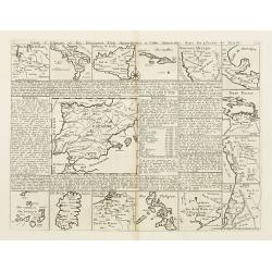
Carte d'Espagne et des Principaux Etats..
Interesting sheet showing 15 maps of Spain and it's overseas possessions. With maps of Philippines, Canary Islands, Sardinia, Cuba, Mexico, Belgium, Sicily and South Amer...
Place & Date: Amsterdam, 1728
Selling price: $100
Sold
Plan de l\'histoire universelle..
Extremely interesting map with a large map of the Eastern Hemisphere, into which is inset a smaller Western Hemisphere with the ISLAND OF CALIFORNIA. Below the map are se...
Place & Date: Amsterdam, 1728
Selling price: $450
Sold in 2008
Plan de l'histoire universelle..
Extremely interesting map with a large map of the Eastern Hemisphere, into which is inset a smaller Western Hemisphere with the ISLAND OF CALIFORNIA. Below the map are se...
Place & Date: Amsterdam, 1728
Selling price: $330
Sold in 2008
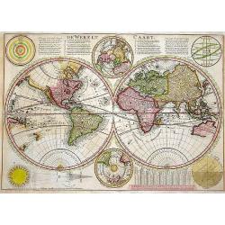
De Werelt Caart.
Published in a Dutch Bible with Biblical text on verso. A beautifully engraved double hemisphere map derived from up-to-date sources of information (probably French). The...
Place & Date: Amsterdam, 1728
Selling price: $1000
Sold in 2013
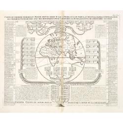
Carte du premier periode du Monde depuis Adam jusque' a Moise ou l'on voit la Chronologie & la genealogie des premeirs patriarches avec des remarques pour conduire a l' intelligence de l' Histoire sacree.
Fascinating engraving depicting a map of the Old World surrounded and keyed to a Biblical genealogical family tree. Panels at the side provide a historical timeline for t...
Place & Date: Amsterdam, 1728
Selling price: $75
Sold in 2013
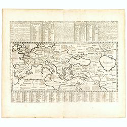
Carte historique chronologique et géographique de l'empire romain où l'on fait observer son étendue et diverses remarques pour l'intelligence de l'histoire.
Interesting sheet with a map of the Roman Empire, with descriptive French text, from Chatelain's monumental 7 volume Atlas Historique. In upper right margin: 'N°10'.Henr...
Place & Date: Amsterdam, 1728
Selling price: $50
Sold in 2016
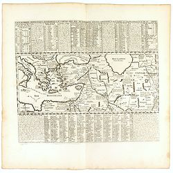
Carte historique chronologique et géographique de l'empire Grec . . .
Interesting sheet with a map of the Roman Empire, with descriptive French text, from Chatelain's monumental 7 volume Atlas Historique. In upper right margin: 'N°10'.Henr...
Place & Date: Amsterdam, 1728
Selling price: $50
Sold in 2017
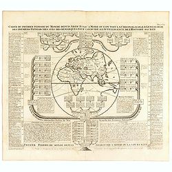
Carte du premier periode du Monde depuis Adam jusque' a Moise ou l'on voit la Chronologie & la genealogie des premeirs patriarches avec des remarques pour conduire a l' intelligence de l' Histoire sacree.
Fascinating engraving depicting a map of the Old World surrounded and keyed to a Biblical genealogical family tree. Panels at the side provide a historical timeline for t...
Place & Date: Amsterdam, 1728
Selling price: $80
Sold in 2016
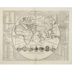
Map monde ou description generale du globe terrestre.
A double hemisphere world map, surrounded by a florid vine pattern with depictions of "Le Soleil Salon le Pere Kircher" and "La Lune Selon Monsieur Cassini...
Place & Date: Amsterdam, 1728
Selling price: $250
Sold in 2022
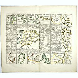
Carte d'Espagne et des Principaux Etats. . .
Interesting sheet showing 15 maps of Spain and it's overseas possessions. With maps of Philippines, Canary Islands, Sardinia, Cuba, Mexico, Belgium, Sicily and South Amer...
Place & Date: Amsterdam, 1728
Selling price: $275
Sold in 2017
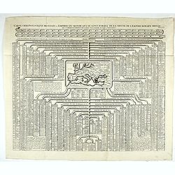
Carte chronologique des etats et empires du monde, qui se sont former de la chute de l’empire romain, depuis le commencement de . . .? vulgaire, jusqu’a present. . .
Extremely interesting sheet with a small map of Europe at the center and chronological tables in French tracing the ancestry of the royal houses of Europe. From: Atlas ...
Place & Date: Amsterdam, 1728
Selling price: $100
Sold in 2023
Nouvelle Mappe-Monde..
Attractively engraved double-hemisphere world map with rich surrounding decoration based on the four seasons. Showing California as an island.From Galerie Agréable du Mo...
Place & Date: Amsterdam 1729
Selling price: $1600
Sold
Mappe-Monde pour connoitre les progres & les conquestes..
Unusual double hemisphere map with California as an Island. Dutch text describes the expeditions and colonial possessions of the Dutch East India Company.The map originat...
Place & Date: Amsterdam, 1729
Selling price: $630
Sold

Mappe-Monde pour connoitre les progres & les conquestes..
Unusual double hemisphere map with California as an Island. Dutch text describes the expeditions and colonial possessions of the Dutch East India Company. The map origina...
Place & Date: Amsterdam, 1729
Selling price: $500
Sold in 2008
Orbis terrarum typus de integro in plurimis emendatus auctus et icunculis illustratus.
Outstanding and rare example of a bible world map based on the Visscher bible map from 1657 (Shirley 401/414). This map is larger in size and has an extra engraved frame ...
Place & Date: Minden, 1729
Selling price: $900
Sold in 2017
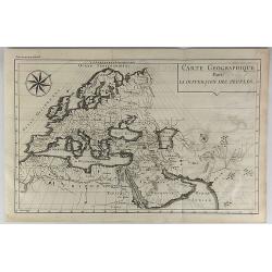
Carte Geographique Pour la Dispersion des Peuples.
A striking map of the ancient world (Europe, North Africa & Western Asia) shows people's dispersion. It is from “METHODE POUR ETUDIER L’HISTOIRE” by L’Abbe Le...
Place & Date: Paris, 1729
Selling price: $75
Sold in 2018
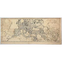
Carte Generale de L'Empire Romain.
A striking map of the Roman Empire. It is from the "METHODE POUR ETUDIER L’HISTOIRE" by L’Abbe Lenglet du Fresnoy, published in Paris in 1729. The map is qu...
Place & Date: Paris, 1729
Selling price: $195
Sold in 2017
Orbis Terrarum Nova et accuratissima tabula.
Double-hemisphere copper engraved map of the world. Shows California as an island, large "Compagnies Land" between the Asian and American continents, and unfini...
Place & Date: Leiden, 1729
Selling price: $320
Sold in 2020
Planiglobii Terrestris Cum Utroq Hemisphaerio..
Vibrantly decorative world map surrounded by vivid engravings of natural phenomena such as waterspouts, a rainbow, earthquakes, and a volcano. Wind heads occupy the starr...
Place & Date: Germany 1730
Selling price: $2300
Sold
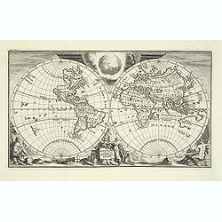
Diversi Globi Terr-Aquei, Statione Variante et Visu Intercendente,
Title: Diversi Globi Terr-Aquei, Statione Variante et Visu Intercendente, per Coluros Tropicorum, per Ambos Polos, et Particul. Sphaerae Zenith in Planum Delineati Orthog...
Place & Date: Germany, c 1730
Selling price: $2500
Sold
Platte Kaart van de geheele Werelt.
This scarce and unusual map of the world is derived from Pierre Mortier's Carte General du Monde of 1700. The map is on Mercator's projection and depicts California as an...
Place & Date: Amsterdam 1730
Selling price: $1200
Sold
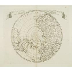
Nuova carta del Polo Artico secondo l'ultime osservazioni ..
From an Italian edition of Solmons work of this attractive map of a north polar projection. CALIFORNIA IS SHOWN AS AN ISLAND and the Pacific region is completely blank. G...
Place & Date: Rome 1730
Selling price: $150
Sold
Werelt Caert.
Dutch so-called ' Staten' bibles, published between 1637 and c. 1760, contained 5 maps: The World, ' Paradise', The Perigrinations, The Promised Land Canaan, The Travels ...
Place & Date: Amsterdam, c. 1730
Selling price: $1500
Sold
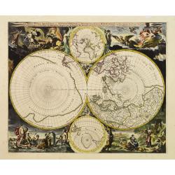
Les Deux Poles Arctique ou Septentrional, et Antarctique..
The distinctive attractiveness of many of the later seventeenth century Dutch world maps is to be found in their border decorations. Nicolaes Berchem has introduced drama...
Place & Date: Amsterdam, 1730
Selling price: $3800
Sold
Planiglobii Terrestris Cum Utroq Hemisphaerio.
Decorative world map surrounded by vivid engravings of natural phenomena such as waterspouts, a rainbow, earthquakes, and a volcano. Wind heads occupy the starry heavens,...
Place & Date: Nuremberg, 1730
Selling price: $1875
Sold
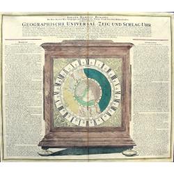
GEOGRAPHISCHE UNIVERSAL - ZEIG UND SCHLAG - UHR
Map of the Northern Hemisphere showing California as an Island. Inspired by the German clockmaker Zacharias Landteck. The map is contained within an engraved table case ...
Place & Date: Nuremberg, c1730
Selling price: $550
Sold in 2011
Nova & Accuratismia Totius Terrarum Tabula Nautica Variationum Magneticarum Index Juxta Obserations Anno 1706 habitas Constructa per Edm. Halley.
Dutch publication of Halley's important chart demonstrating the variations of the compass, created by him in 1701. Though best known as the discoverer of the comet which ...
Place & Date: Amsterdam 1702/ 1730
Selling price: $7400
Sold
Werelt Caert Orbis terrarum
Lovely double hemisphere map from a Dutch Bible. Title inside the surrounding allegorical representations of the continents, based on Visscher. CALIFORNIA IS AN ISLAND wi...
Place & Date: Amsterdam, 1730
Selling price: $1050
Sold
Planiglobium Terrestre Minus in hanc formam reductam
This uncommon map is based on Johann Baptist Homann's Planiglobii Terrestris Cum Utrog Hemisphaerio Caelesti and is embellished with similar engravings of natural phenome...
Place & Date: Nuremberg, 1730
Selling price: $1200
Sold
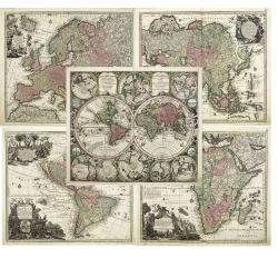
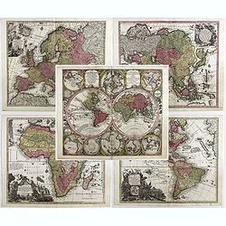
Diversi GLOBI TERR-AQUEI Statione Variante et Visu intercedente,. . .
A matching set of the world in double hemispheres and maps of the four continents.Here in a first edition without the privilege.Diversi GLOBI TERR-AQUEI Statione Variante...
Place & Date: Augsbourg, c.1730
Selling price: $5400
Sold in 2011
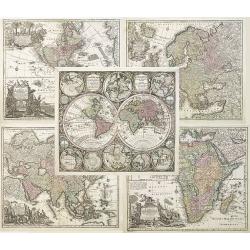
Diversi GLOBI TERR-AQUEI Statione Variante et Visu intercedente,...
A matching set of the world in double hemispheres and maps of the four continents.Here in a first edition without the privilege.Diversi GLOBI TERR-AQUEI Statione Variante...
Place & Date: Augsbourg, 1730
Selling price: $4800
Sold in 2010
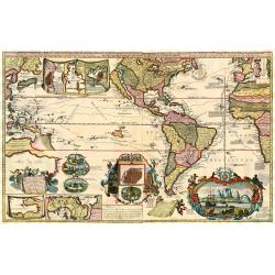
Carte Generale du Monde, ou Description du Monde Terrestre & Aquatique
Pierre Mortier's unique world map drawn on Mercator's projection with California as an island and the Detroit d'Anian connected by dotted lines through the Northwest Pass...
Place & Date: Amsterdam, 1730
Selling price: $650
Sold in 2011
Nova & Accuratismia Totius Terrarum Tabula Nautica Variationum Magneticarum Index Juxta Obserations Anno 1706 habitas Constructa per Edm. Halley.
Dutch publication of Halley's important chart demonstrating the variations of the compass, created by him in 1701. Though best known as the discoverer of the comet which ...
Place & Date: Amsterdam, 1702/ 1730
Selling price: $8600
Sold in 2011
Carte Generale du Monde, ou Description du Monde Terrestre & Aquatique
This is Pierre Mortier's unique world map drawn on Mercator's projection. It depicts California as an island and the Detroit d'Anian connected by dotted lines through the...
Place & Date: Amsterdam, 1730
Selling price: $750
Sold in 2012
De Tweede Weereld Door Noachs Dry Zonen Bevolkt
This Charming copper plate etched map shows the world as known after the Great Flood. The title cartouche features Noah and his sons. The four coins along the bottom repr...
Place & Date: Amsterdam, 1730
Selling price: $75
Sold in 2013
Werelt Caert.
The map is based on Nicolas Visscher's map of 1663, drawn by Daniel Stoopendaal for publication in the Keur Bible. This map depicts the world on a hemisphere projection ...
Place & Date: Dordrecht, (1663) 1730
Selling price: $750
Sold in 2013
Platte Kaart van de geheele Werelt.
This scarce and unusual map of the world is derived from Pierre Mortier's Carte General du Monde of 1700. The map is on Mercator's projection and depicts California as an...
Place & Date: Amsterdam, 1730
Selling price: $359
Sold in 2013
Diversi GLOBI TERR-AQUEI Statione Variante et Visu intercedente,. . .
A matching set of the world in double hemispheres and maps of the four continents.Here in a first edition without the privilege.Diversi GLOBI TERR-AQUEI Statione Variante...
Place & Date: Augsbourg, c.1730
Selling price: $4800
Sold in 2017
Carte Nouvelle de la Mer du Sud.
Large and spectacular map on 2 joined sheets, title, most cartouches and place names in French, one cartouche in Latin and one in Dutch. The engraved vignettes include: a...
Place & Date: Amsterdam, 1730
Selling price: $7600
Sold in 2018
Planiglobii Terrestris Cum Utroq Hemisphaerio...
Extremely decorative, large world map surrounded by vivid engravings of natural phenomena such as waterspouts, a rainbow, earthquakes, and a volcano. Wind heads occupy th...
Place & Date: Nurenberg, 1730
Platte Kaart van de Geheele Werelt.
Title in a cartouche with two angels at top centre. Left and right double hemispheres (of the two poles and East and West continents).An unusual map showing California ...
Place & Date: Amsterdam, 1730
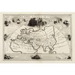
Veteris Orbis Climata Ex Strabone..
Old World climates according to Strabo. Europe, Asia, and northern Africa are surrounded by eight compass points worth of wind heads. Of particular interest is 'Aquilo,' ...
Place & Date: Leipzig 1731
Selling price: $130
Sold
Mappe-monde pour servir a l'histoire des decouvertes et conquestes des Portugais dans le nouveau monde.
Oval world map showing some of the tracks of early Portuguese voyagers, prepared by Joseph Francois Lafitau (1681-1746), included in: "Histoire des decouvertes et co...
Place & Date: Paris, 1733
Selling price: $425
Sold in 2008
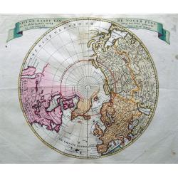
Nieuwe Kaart van de Noord Pool. . .
Interesting map with north polar projection. California is shown as an Island, and unfinished coast lines of the North-West. Shows New Denmark, Greenland, Compagnie Land,...
Place & Date: Amsterdam, 1735
Selling price: $200
Sold in 2015
Mappe Monde suivant les Nouvelles Observations. . .
A very decorated World map, using the plate of Pieter Van der Aa from the beginning of the 18th century, by Covens & Mortier, published in the ´Atlas Covens´, Nouve...
Place & Date: Amsterdam, ca 1735
Selling price: $410
Sold in 2019
Diversi Globi Terr-Aquei Statione variante (...)
A large-sized 18th-century world map with several (8) Globi Terr-Aquei and border decorations. From: Matthias Seutter, ‘Atlas Novus sive Tabulae Geographicae totius or...
Place & Date: Augsburg, ca. 1735
Selling price: $1400
Sold in 2023
Werelt Caert. Orbis terrarum
Lovely double hemisphere map from a Dutch Bible. Title inside the surrounding allegorical representations of the continents, based on Visscher. CALIFORNIA IS AN ISLAND wi...
Place & Date: Amsterdam, 1736
Selling price: $900
Sold in 2008
Carte pour servir à la lecture de l'histoire ancienne des Egyptiens, des Carthaginois, des Assyriens, des Babyloniens, des Medes, des Perses, des Macedoniens, des Grecs: par M. Rollin ancien recteur de l'université de Paris.
This map depicts the western part of the Ancient World, Partie Occidentale de la Carte des Anciennes Monarchies including southern Europe and northern Africa. An inset ma...
Place & Date: Paris, 1737
Selling price: $150
Sold in 2009
Carte pour servir à la lecture de l\'histoire ancienne des Egyptiens, des Carthaginois, des Assyriens, des Babyloniens, des Medes, des Perses, des Macedoniens, des Grecs: par M. Rollin ancien recteur de l\'université de Paris.
This map depicts shows the eastern portion Partie Occidentale de la Carte des Anciennes Monarchies including the Middle East, Persia and the Indus River Valley. An inset ...
Place & Date: Paris, 1737
Selling price: $200
Sold in 2009
The World: A New and Correct Map laid down & described according to the latest discoveries. . .
'The World: A New and Correct Map laid down & described according to the latest discoveries, to which is added and Explanation of all these Lines (as the Equator, Ecl...
Place & Date: London, 1738
Selling price: $3900
Sold in 2019
Basis Geographiae recentioris astronomica..
Baroque period world map in double hemispheres showing the shapes of land masses exactly calculated from astronomical observations. Roundel vignettes show cherubs making ...
Place & Date: Nuremberg 1740
Selling price: $540
Sold
Mappe-Monde ou Description du Globe Terrestre. . .
Very rare large world map in double hemisphere. The map surround is filled with a large number of hemispheres, including one polar hemisphere. Showing the tracks of Magel...
Place & Date: Amsterdam, 1740
Selling price: $3000
Sold in 2017
Basis Geographiae Recentioris Astronomica
Worldmap in double hemisphere. California as an Island. From the Doppelmayr \"Atlas Coelestis\" published by J.B. Homann in Nuremberg.
Place & Date: Nuremberg, 1740
Selling price: $450
Sold in 2009
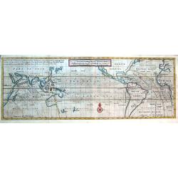
A View of ye General & Coasting Trade-Winds, Monsoons or ye Shifting Trade Winds through ye World, Variations &c.
Curious map of a large part of the world indicating the trade winds. Centered on the Great South Sea. Shows Arabia, Japan, California, north up to Newfoundland. South unt...
Place & Date: London, ca. 1740
Selling price: $275
Sold in 2016
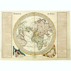
Horizon de Paris. . .
Large circular world map between California, Japan and South- Africa according to a projection centered on Paris, with a diameter of 570mm. Published by André Durand in ...
Place & Date: Paris, 1740
Selling price: $850
Sold in 2020
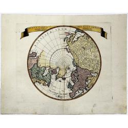
NUOAVA CARTA DEL POLO ARTICO. . . (California as an Island)
A colored, decorative map of the Northern Hemisphere and the North Pole, which shows the possibility of the Northeast Passage, but no definite Northwest Passage.
Place & Date: Venice, 1740
Selling price: $110
Sold in 2019
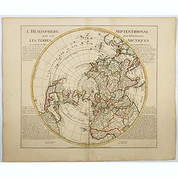
l'Hemisphere Septentrionale pour voir plus distinctement Les Terres Arctiques. . .
This is a stunning and terrific map of the Northern Hemisphere that was originally drawn by Guillaume de L'Isle in 1714 and updated by Coven's and Mortier in 1741. It co...
Place & Date: Amsterdam 1740
Selling price: $160
Sold in 2023
Globus Terrestris ex probatissimis recentiorum?.
Attractive copper engraved map of the world. Charming double hemisphere map surrounded by engravings of the heavens and natural phenomena such as waterspouts, a rainbow, ...
Place & Date: Leipzig, 1741
Selling price: $250
Sold