Browse Listings in World Maps
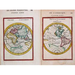
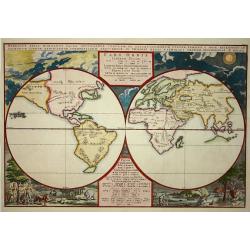
Nouveau Continent ou Amerique. / Ancien Continent
Two separate attractive little maps of the Old and the New World. 'Nouveau Continent ou Amerique. / Ancien Continent.' Alain Manneson Mallet (1603-1706) published in 1683...
Place & Date: Paris, 1683 / Frankfurt, 1686
Selling price: $100
Sold in 2020
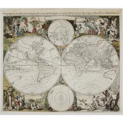
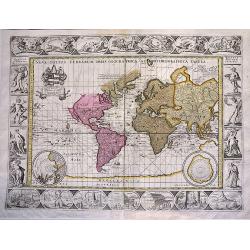
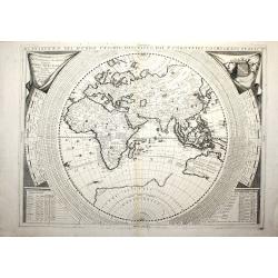
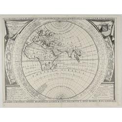
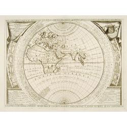
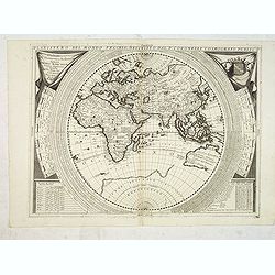
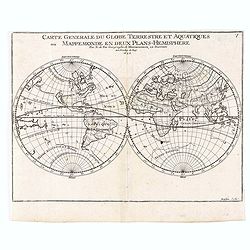
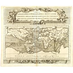
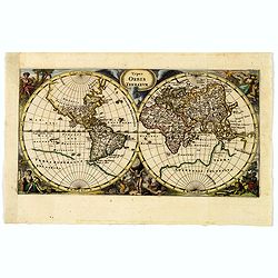
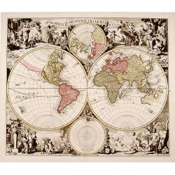
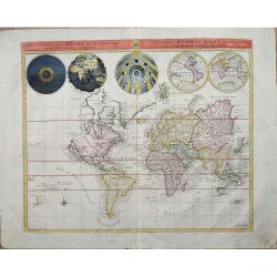
Mappe-Monde Geo-Hydrographique, ou Description Generale du Globe Terrestre et Aquatique en Deux-Plans-Hemispheres…
This is very rare and decorative double-hemisphere world map decorated with vignettes representing the four seasons, after Jaillot’s similarly-titled world map publishe...
Place & Date: Amsterdam, c. 1686
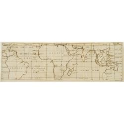
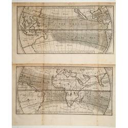
![[continental trade winds map] Bibliotheque universelle et historique, tome 4.](/uploads/cache/91846-250x250.jpg)
[continental trade winds map] Bibliotheque universelle et historique, tome 4.
A book containing Edmund Halley's landmark map -- the first meteorological chart of the world's tropical oceans. His map depicts the oceanic flows, trade wind zones, and ...
Place & Date: Amsterdam, 1687
Selling price: $300
Sold in 2016
![[ World ]](/uploads/cache/30328-250x250.jpg)
[ World ]
Charming oval wood block map of the world, with a large Southern continent "Circolo Antartico Terra Incognita Australe" by the Italian XVIth and XVIIth century ...
Place & Date: Bologna, Antonio Pisarri, 1594 - 1688
Selling price: $250
Sold in 2011
![[ World ]](/uploads/cache/30327-250x250.jpg)
[ World ]
Charming wood block map of a world projection, with a large Southern continent "Tera Incognita Australe" by the Italian XVIth and XVIIth century writer, humanis...
Place & Date: Bologna, Antonio Pisarri, 1594 - 1688
Selling price: $140
Sold in 2011
![[ World map ]](/uploads/cache/30312-250x250.jpg)
[ World map ]
Charming wood block oval-projection world map by the Italian XVIth and XVIIth century writer, humanist and cartographer Giuseppe Rosaccio, with six wind heads . The inter...
Place & Date: Bologna, 1592 - 1688
Selling price: $500
Sold in 2011
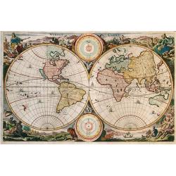
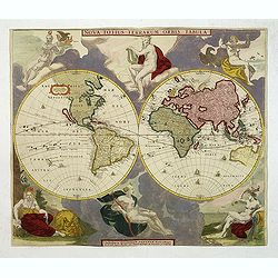
Werelt Caert.
Beautiful double hemisphere from a Dutch Bible. Surrounded by allegorical representations of the continents, based on Visscher. CALIFORNIA IS AN ISLAND with a flat northe...
Place & Date: Amsterdam 1688
Selling price: $1000
Sold in 2009
![[ World ]](/uploads/cache/31644-250x250.jpg)
[ World ]
Charming wood block map of the globe (diameter 62mm.) by the Italian XVIth and XVIIth century writer, humanist and cartographer Giuseppe Rosaccio.With a large Southern co...
Place & Date: Bologna, Antonio Pisarri, 1594 - 1688
Selling price: $110
Sold in 2011
![[ World ]](/uploads/cache/32270-250x250.jpg)
[ World ]
Charming oval wood block map of the world, with a large Southern continent "Circolo Antartico Terra Incognita Australe" by the Italian XVIth and XVIIth century ...
Place & Date: Bologna, Antonio Pisarri, 1594 - 1688
Selling price: $110
Sold in 2012
![[Title page ] Teatro del Mondo e sue parti cioe' Europe, Africa, Asia, et America,. .](/uploads/cache/32271-250x250.jpg)
[Title page ] Teatro del Mondo e sue parti cioe' Europe, Africa, Asia, et America,. .
Theitle page includes a charming wood block map of a world projection, with a large Southern continent "Tera Incognita Australe" by the Italian XVIth and XVIIth...
Place & Date: Bologna, Antonio Pisarri, 1594 - 1688
Selling price: $100
Sold in 2012

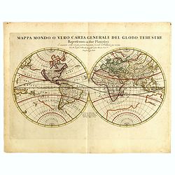
Mappa mondo o vero carta generale del globo terestre...
Giacomo Rossi's fine late 17th century double hemisphere world map. Showing California as an island. Issued in Il Mercurio geografico The cartographer was Giacomo Cantell...
Place & Date: Rome, 1674-1688
Selling price: $500
Sold in 2015
Mappa mondo o vero carta generale del globo terestre...
Giacomo Rossi's fine late 17th century double hemisphere world map. Showing California as an island. Issued in Il Mercurio geografico The cartographer was Giacomo Cantell...
Place & Date: Rome, 1674-1688
Selling price: $600
Sold in 2019
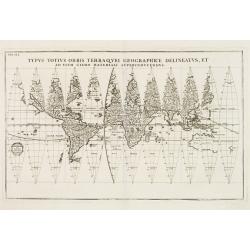
Nova Totius Terrarum Orbis Geographica ac Hydrographica Tabula.
An extremely decorative world map. It appeared in the famous 'English Atlas' by Moses Pitt and Steven Swart and is based on an earlier engraved world map by Pieter van de...
Place & Date: Oxford, 1689
Selling price: $2950
Sold in 2019
(No title) Eastern Hemisphere.
Uncommon map of the eastern hemisphere with Europe, Africa, Asia and Australia. Text in German and showing two tracks from England and Holland to Indonesia continuing to ...
Place & Date: Germany, c. 1690
Selling price: $600
Sold in 2016
A view of the General & Coasting Trade-Winds in the Atlantic
An uncommon map of the Oceans with its currents and winds between 35degrees North and 35degrees South latitude.To the right Formoso (Taiwan), part of Japan and part of Au...
Place & Date: London c.1690
Selling price: $300
Sold
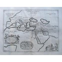
Geographiae Sacrae .. Totius Orbis Partes..
Standard map of the ancient world. Centred on Cyprus. With inset map of Egypt.This edition carries the date 1690.Nicolas Sanson was to bring about the rise of French cart...
Place & Date: Paris 1690
Selling price: $160
Sold
Planisfero del Mondo Nuovo, Descritto dal P. Coronelli, Cosmografo Publico.
A very fine map of the Eastern hemisphere including the discoveries made by Abel Tasman in Australia. The decorative borders include co-ordinates and descriptions of sign...
Place & Date: Venise, c. 1690
Selling price: $1600
Sold in 2012
Geographia sacra.
From the Hornius edition of the atlas of the Ancient World by Janssonius. No text on verso.
Place & Date: Amsterdam, ca 1690
Selling price: $120
Sold in 2010
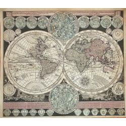
Planisphaerium terrestre, cum utroque coelesti hemesphaerio, sive diversa orbis terraquei.
Published in Amsterdam in 1709, it presents 26 diagrams (!!!) 9 of which refers to different angles of the Earth, and the other to astronomical diagrams. Two larger diagr...
Place & Date: Amsterdam, 1690
Selling price: $1450
Sold in 2017
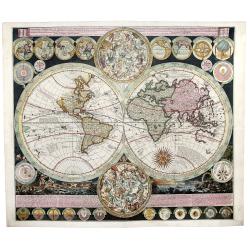
Le Globe Terrestre Represente en Deux Plans-Hemispheres, et en Diverses autres Figures..
A copper-engraved double-hemisphere map of the world, surrounded by smaller hemispherical and oval maps, hand-colored in outline.Significant world map at the end of the 1...
Place & Date: Paris, 1690
Selling price: $2500
Sold in 2017
Aevi Veteris Usque Ad Annum Salutis Nonagesimum Supra Milles Quaringentos Cogniti Tantum Typus Geogrpahic:... MDCLXXXVIIIII.
Coronelli’s interesting map of the Old World, Eastern hemisphere, dedicated to Jacobo Marcello. The map covering most of Africa and the Indian Ocean, but no Japan or Ch...
Place & Date: Venice, 1690
Selling price: $1000
Sold in 2018
Astygnomon sive Europaearum urbium maxime insignium index. . . .
From "Atlas contractus sive mapparum geographicarum Sansoniarum auctarum et correctarum nova congeries". Showing tables with distances between European cities. ...
Place & Date: Amsterdam, 1690
Selling price: $120
Sold in 2021
A map of all the Earth and how after the flood it was. . .
Second state of this very uncommon, oval world map. The map is surrounded by vignettes illustrating the Creation, the Garden of Eden and several Biblical scenes, includin...
Place & Date: London, ca.1681 but before 1691
Selling price: $1000
Sold in 2012
Aevi Veteris que ad annum salutis nonagesimum supra milles quadringentos cogniti ..
Decorative map by the late 17th century Venetian mapmaker Vincenzo Coronelli. The map is based upon classical Geography, covering most of Africa and the Indian Ocean, but...
Place & Date: Venice 1691
Selling price: $500
Sold
![[Set of 2 maps] Planisfero del Mondo Vecchio,../ Planisfero del mondo nuovo..](/uploads/cache/16508-250x250.jpg)
[Set of 2 maps] Planisfero del Mondo Vecchio,../ Planisfero del mondo nuovo..
Two maps by the late 17th-century Venetian mapmaker Vincenzo Coronelli. The first one is an excellent map of the Eastern hemisphere, including the discoveries made by Abe...
Place & Date: Venice 1691
Selling price: $4500
Sold
Planisfero del Mondo Vecchio. . .
A decorative map of the Eastern hemisphere includes Abel Tasman's discoveries in Australia. The decorative borders include coordinates and descriptions of signs of the zo...
Place & Date: Venice, 1691
Selling price: $1800
Sold in 2015
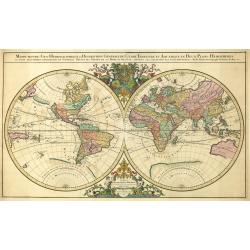
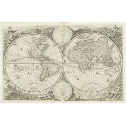
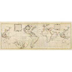
Mappe-Monde Geo-Hydrographique, ou Description Generale du Globe Terrestre et Aquatique en Deux-Plans Hemispheres.
Large-scale world map in two hemispheres prepared by N.Sanson. At the top cherubs with flowing banners are seated astride dolphins and support the arms of France. At the ...
Place & Date: Paris, 1691
Selling price: $3300
Sold in 2018
Planisfero Del Mondo Nuovo, Descritto Dal P. Coronelli, Cosmographo Publico.
A large, decorative map of the Western Hemisphere by Coronelli from his 'Atlante Veneto'. It is historically important because it includes the discoveries by Abel Tasman ...
Place & Date: Venice, 1691
Selling price: $1200
Sold in 2021
World map. (No title).
Charming double-hemispherical world map signed by Peeters (initials P.I. rather than J ) and engraved by Jacob Harrewijn.California as an island.There are neat groups of ...
Place & Date: Amsterdam 1692
Selling price: $325
Sold
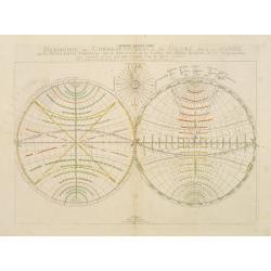
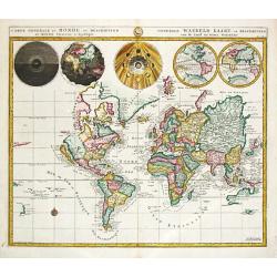
Sphere Armillaire - Harmonie ou Correspondance du Globe avecq la Sphere par les Points, Lignes, Cercles, &c. qui se descrivent en la surface des Globes Terrestres et des Mappemondes, pour respondre a ceux qui sont imaginés dans la Sphere Celeste.
A large map of the world in two hemispheres, east and west, showing the climatic zones. The geographic content is relegated to the background, placing emphasis on the gri...
Place & Date: Paris, 1692
Selling price: $70
Sold in 2011
![[6 maps] Mappe-Monde Géo-Hydrographique? / L'Afrique? /Amérique Méridionale? / Amérique Septentrionale? / L'Asie? / L'Europe?](/uploads/cache/99030-250x250.jpg)
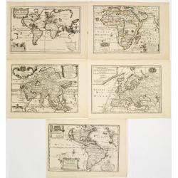
[6 maps] Mappe-Monde Géo-Hydrographique? / L'Afrique? /Amérique Méridionale? / Amérique Septentrionale? / L'Asie? / L'Europe?
A matching set of a world map and 4 continents. Published by Pierre Mortier the maps are close copies of the maps by Alexis Hubert Jaillot of 1674. Allthrough the maps be...
Place & Date: Amsterdam, 1692
Selling price: $11000
Sold in 2008
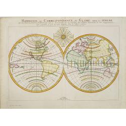
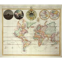
Harmonie ou Correspondance du Globe avecq la Sphere par les Points, Lignes, Cercles, &c. qui se descrivent en la surface des Globes Terrestres et des Mappemondes, pour respondre a ceux qui sont imaginés dans la Sphere Celeste.
A large map of the world in two hemispheres, east and west, showing the climatic zones. The geographic content is relegated to the background, placing emphasis on the gri...
Place & Date: Paris, ca. 1692
Selling price: $180
Sold in 2010
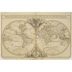
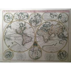
Mappe-Monde Geo-Hydrographique, ou Description Generale du Globe Terrestre et Aquatique en Deux Plans-Hemispheres ou Sont Exactement Remarques en General Toutes Les Parties ...
Mappe-Monde Geo-Hydrographique, ou Description Generale du Globe Terrestre et Aquatique en Deux Plans-Hemispheres ou Sont Exactement Remarques en General Toutes Les Parti...
Place & Date: Amsterdam, P.Mortier, 1691-1692
Selling price: $1200
Sold in 2014
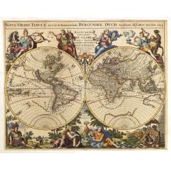
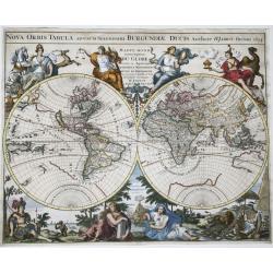
Nova Orbis Tabula, adusum Serenissimi Burgundiae..
The decorative world map was prepared by Hubert Jaillot for his 'Atlas Royal' which was first published by de Fer in 1695. Eight large allegorical figures are shown each ...
Place & Date: Paris, 1694
Selling price: $2000
Sold in 2018
Den Aardkloot van water ontbloot, na twee zijden aante sien.
Uncommon map of the world, shown as if the oceans were dried up. California is an island, with a single Great Lake, and Australia is partially formed.From a Dutch edition...
Place & Date: Amsterdam, 1694
Selling price: $285
Sold in 2011
Den Aardkloot van water ontbloot, na twee zijden aante sien ("The Entire Planet Devoid of Water, Seen on Two Sides")
An uncommon map of the world, shown as if the oceans were dried up. California is an island, with a single Great Lake, and Australia is partially formed.From a Dutch edit...
Place & Date: Amsterdam, 1694
Selling price: $50
Sold in 2020
Nova orbis tabula, ad usum serenissimi Burgundiae ducis.
A finely engraved double-hemisphere map of the world with fine, full hand color with the title in a banner across the top edges, and surrounded by an elaborate allegorica...
Place & Date: Paris, 1694
Selling price: $2100
Sold in 2021
Universalis Tabula juxta Ptolemaeum ...
This map is the revised second state of Mercator's 1578 Ptolemaic world map. The border has been re-engraved, and now includes a frieze of allegorical figures representin...
Place & Date: Amsterdam/Leiden, 1695
Selling price: $2600
Sold in 2013
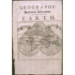
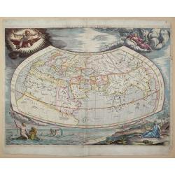
\"A Particular Description of The Known Parts Of The Earth\"
Interesting 1701 double hemisphere world map from Moll's 'A System of Geography', with an incomplete Australia and California depicted as an island. Includes a global vie...
Place & Date: London, 1695
Selling price: $220
Sold in 2015
Carte generale du Globe Terrestre Aquatiques.
Double hemisphere showing California as an island. A great southern continent is partially outlined. Published by Nicolas De Fer, Royal French Geographer.
Place & Date: Paris, 1695
Selling price: $150
Sold in 2020
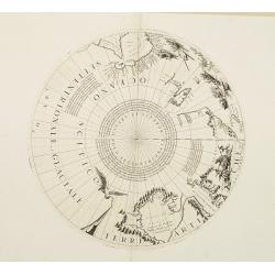
2 Polar calottes from a globe.
Set of two polar calottes from 110 centimetres in diameter globe of 1688 including northern part of Baffin Bay, Greenland, Nova Zembla. Coronelli elected to follow the Du...
Place & Date: Venice 1696
Selling price: $900
Sold
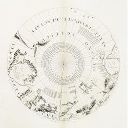
Polar calottes from a globe.
Rare polar calottes from a 110 centimetres in diameter globe of 1688 including northern part of Baffin Bay, Greenland, Nova Zembla. Coronelli elected to follow the Dutch ...
Place & Date: Venice 1696
Selling price: $1250
Sold
Tabula geographico-hydrographica motus Tom II p.132.
World map depicting ocean currents, volcanoes and deep-sea chasms. The continents are void of political detail and only major lakes, rivers and volcanoes are shown. There...
Place & Date: Nuremberg, 1696
Selling price: $1500
Sold in 2011
Nova Totius Terrarum Orbis Tabula.
Two hemispheres surrounded by six robust statuesque figures representing Day and Night and the four elements, each, except for mother Earth, proudly unclothed. Subsequent...
Place & Date: Amsterdam, 1688-1697
Selling price: $15500
Sold in 2011
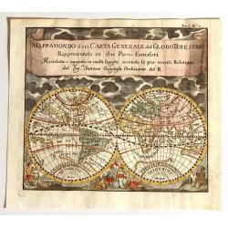
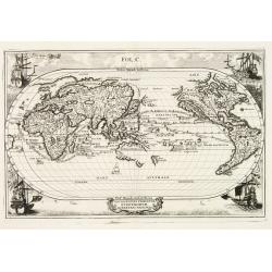
MappaMondo o sia Carta Generale del Globo Terestre Rappresentata in due Pian§Emisferi. . .
Beautiful small double hemisphere map decorated with clouds at the top and allegorical figures of the four continents: America the dangerous, strong Europe, exotic Asia, ...
Place & Date: Antwerp: Jan Duren, 1697
Selling price: $275
Sold in 2015
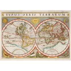
Typus Orbis Terrarum.
Interesting double hemisphere from Philipp Clüver's famous Introductionis in Universam geographicam, first published in Leiden in 1624. Philipp Clüver (1580–1623) was...
Place & Date: Amsterdam, 1697
Selling price: $170
Sold in 2017
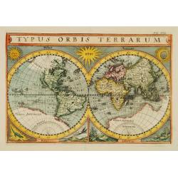
Typus Orbis Terrarum.
A very decorative world map showing the 'bulge' in South America, California as an peninsula and only a very rudimentary form of Australia. In fact, 'Terra Australis Inco...
Place & Date: Amsterdam, ca 1697
Selling price: $380
Sold in 2019
Benedict. Arias Montanus Sacrae Geographiae Tabula..
This striking double hemisphere world map is a rare variant of Montanus' Polyglot Bible map of 1571/1572. Principally showing how Noah's three sons repopulated the world,...
Place & Date: Amsterdam, 1698
Selling price: $3500
Sold in 2008
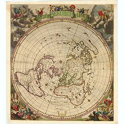
WereltCaert.
World-map, originally designed by Nicholas Visscher in 1663. Adapted by Keur and inserted in his bible in 1698. Very good world-map, in the four corners are representat...
Place & Date: Dordrecht ,1698
Selling price: $850
Sold
A view of the General & Coasting Trade-Winds in the Atlantic
The world in two parts each focussing on the trade wind belt between 35degrees North and 35degrees South latitude. Engraved by Herman Moll. Based on Halley's 1686 wind ma...
Place & Date: London 1699
Selling price: $180
Sold
![Repraesentatio geographica itineris maritimi navis victoriae in qua ex personis CCXXVII finita navagatione rediere tantum XVII quae solo indusio tectae. . . [Magellan's circumnavigation]](/uploads/cache/85223-250x250.jpg)
Repraesentatio geographica itineris maritimi navis victoriae in qua ex personis CCXXVII finita navagatione rediere tantum XVII quae solo indusio tectae. . . [Magellan's circumnavigation]
This map shows the first World circumnavigation, journey of the ship Victoria of Ferdinand Magellan’s expedition, from and to Sevilla, thus the first ship ever to circu...
Place & Date: Munich, 1699
Selling price: $800
Sold in 2021
Orbis terrarum nova et accurata..
Exquisitely decorated double hemisphere world map. The map has been updated geographically compared to Valck's earlier ones. The map's outer decoration is the same as tha...
Place & Date: Amsterdam 1700
Selling price: $5425
Sold
Typus orbis terrarum.
World map in double hemisphere showing California as an island.With in top the sun and the moon, in the lower part a representation of Fire, Air, Earth and Water. With a ...
Place & Date: c.1700
Selling price: $400
Sold
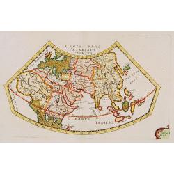
Orbis Pars Veteribus Cognita.
A very nice map showing ancient world.
Place & Date: Paris, ca. 1700
Selling price: $360
Sold
Typus Orbis Terrarum.
Uncommon double hemisphere world map, showing California as an island. In corners sun, moon and representations of four elements. With a large southern continent, but Aus...
Place & Date: Germany c.1700
Selling price: $550
Sold
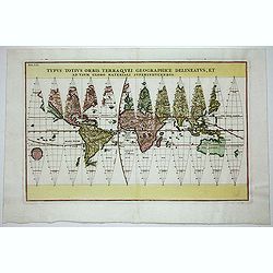
Typus Totius Orbis Terraquei Geographice..
Finely engraved set of 12 globe gores. Fascinating Northwest Passage treatment. Excellent detail in Australia and a nice bit of New Zealand shown, along with a curious ov...
Place & Date: Munich 1700
Selling price: $850
Sold
Navigationes Praecipuae Europaeorum ad Exteras Nationes.
Splendid map of the world on an oval projection showing California as an Island and partially mapped Australia and New Zealand.This map is from the series produced by Sch...
Place & Date: Munich 1700
Selling price: $1400
Sold
Carte Generale Du Monde.
Pieter Mortier (1661-1711), Amsterdam bookseller and printer of French descent published a.o.the atlas and the sea-atlas of Sanson-Jaillot and of de l\' Isle. The firm co...
Place & Date: Amsterdam, 1700
Selling price: $950
Sold in 2009
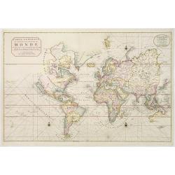
Carte Generale du Monde..
Pierre Mortier's unique world map drawn on Mercator's projection with California as an Island and the Detroit d'Anian connected by dotted lines through the Northwest Pass...
Place & Date: Amsterdam 1700
Selling price: $1230
Sold
Typus Totius Orbis Terraquei Geographice
Finely engraved set of globe gores. This is one of eleven world maps, which appeared in the Novus Atlas that was published between 1702 and 1710. CALIFORNIA IS AN ISLAND,...
Place & Date: Munich c.1700
Selling price: $1150
Sold
Carte générale du monde, ou description du monde Terrestre & Aquatique.
Beautiful world map from a Dutch Bible. The map is drawn on Mercator's projection with CALIFORNIA AS AN ISLAND and the Detroit d'Anian connected by dotted lines through t...
Place & Date: Amsterdam, 1700
Selling price: $800
Sold
Korte Beschrijvinge van de Lantschappen des WERELTS
Double hemisphere world map. Surrounded by allegorical representations of the continents, based on Visscher. Australia is partially mapped and there is only a hint of New...
Place & Date: Amsterdam, c. 1700
Selling price: $1350
Sold in 2009
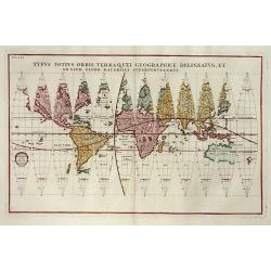
Typus Totius Orbis Terraquei Geographice Delineatus.
Finely engraved set of 12 globe gores. Fascinating Northwest Passage treatment. Excellent detail in Australia and a nice bit of New Zealand shown, along with a curious ov...
Place & Date: Munich, 1700
Selling price: $376
Sold in 2014
Repraesentatio Geographica Itineris Maritimi Navis Victoriae..
This very graphic map of the world is presented on a north polar projection and depicting all of the world except the South Pole. California is shown as an island and the...
Place & Date: Munich, ca. 1700
Selling price: $1000
Sold in 2012
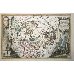
Nieuw Aerdsch Pleyn.
This rare world map in acartographical unusual" single polar projection.The copper plate was first published separately by Jacob Robyn in 1696. Already around 1700, ...
Place & Date: Amsterdam, c. 1700
Selling price: $5800
Sold in 2019
(5 Maps !!!!!) Carte generale du monde. . ./ Voyage des enfant d\'israel / Het heylige land...Israels /Byzondere Kaart van de Landen daar de Apostelen. . . / Carte de la situation du paradis terrestre. . .
Beautiful world map from a Dutch Bible. The map is drawn on Mercator's projection with CALIFORNIA AS AN ISLAND and the Detroit d'Anian connected by dotted lines through t...
Place & Date: Amsterdam, 1700
Selling price: $604
Sold in 2013
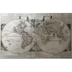
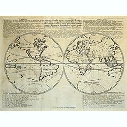
Mappe-Monde, ou Carte Generale de la Terre, Divisee en Deux Hemispheres Suivant la Projection la Plus Commune ou Tous les Points Principaux sont Placez sur les Observations de Mrs. de l'Academie Royale des Siences
A copper-engraved double-hemisphere map, hand-colored in outline, with colored pictorial representations as background, engraved text at top and bottom.A rare first state...
Place & Date: Paris, 1700
Selling price: $2400
Sold in 2017
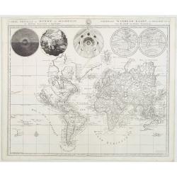
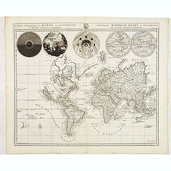
PLANISPHAERIUM TERRESTRE CUM UTROQUE COELESTI HEMISHERIO, SIVE DIVERSA ORBIS TERRAQUEI.
A fine example of Adam Freidrich Zurner's scarce double hemisphere map of the World, embellished with 26 decorative scenes and scientific projections of the Celestial ski...
Place & Date: Amsterdam, P.Schenk, 1700
Selling price: $2000
Sold in 2019
![GEOGRAPHISCHE UNIVERSAL-ZEIG UND SCHLAG-UHR.[Rare first edition]](/uploads/cache/83574-250x250.jpg)
GEOGRAPHISCHE UNIVERSAL-ZEIG UND SCHLAG-UHR.[Rare first edition]
A map of the Northern Hemisphere showing California as an Island. Inspired by the German clockmaker Zacharias Landteck. The map is placed within an engraved table case cl...
Place & Date: Nuremberg, ca 1700
Selling price: $1200
Sold in 2020
CARTE GENERALE DU MONDE, OU DESCRIPTION DU MONDE TERRESTRE & AQUATIQUE
Covens & Mortier’s world map drawn on Mercator’s projection. It depicts California as an island and the Detroit d’Anian connected by dotted lines through a No...
Place & Date: Amsterdam, 1700
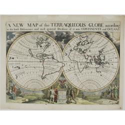
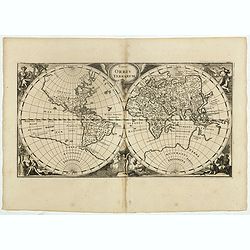
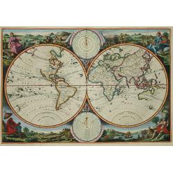
A New Map of the Terraqueous Globe. . .
A highly decorative double hemisphere map of the World. It shows California as an island, an incomplete New Holland, a partially explored Australia attached to New Guinea...
Place & Date: Oxford, 1700
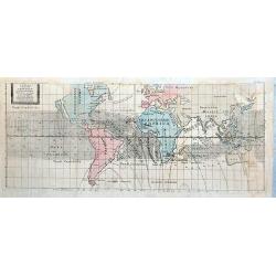
Tabula Totius Orbis Terrarum Exhibens Declinationes Magneticas, ad Annum 1700 composita ab Edmundo Halleyo simul cum Inclinationibus a Poundio observatis et Ventis Universalibus.
French publication of Halley's important chart demonstrating the variations of the compass, created by him in 1701. Though best known as the discoverer of the comet which...
Place & Date: Paris c.1701
Selling price: $200
Sold
Tabula Totius Orbis Terrarum Exhibens Declinationes Magneticas, ad Annum 1700 composita ab Edmundo Halleyo simul cum Inclinationibus a Poundio observatis et Ventis Universalibus.
French reduced version of Edmond Halley (1656-1742) world map. California is shown as an island, Australia is only partially mapped, and New Zealand is not shown. The m...
Place & Date: Paris, 1701
Selling price: $615
Sold in 2021
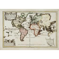
Mappe Monde pour connaitre les progrès et les conquestes les plus Remarquables des Provinces-Unies
Interesting world map related to the global Dutch commercial ventures of the VOC and WIC. Showing California as an island.
Place & Date: Amsterdam, 1701
Selling price: $210
Sold in 2018
Mappe-Monde ou carte Universelle..
Uncommon world map showing California as an island. Engraved by C.Inselin.
Place & Date: Paris 1702
Selling price: $520
Sold
Societas Jesu..
A map from the series of maps by the Jesuit mathematician. The map is presented on a polar projection and is shaded to indicate the spread of the Catholic religion throug...
Place & Date: Munich c.1702
Selling price: $913
Sold
Carte Generale des toutes les Costes du Monde avec un Indice des Variations Magnetiques selon les Observations Faites en l\'Année 1700.
Large-scale world map by the well-known English scientist Edmund Halley, after whom the famous comet was named. But of greater importance were his studies on terrestrial ...
Place & Date: Amsterdam ca. 1702
Selling price: $7200
Sold
Set of world and 4 continents.
Uncommon set of world and continents. The maps of the World and North America showing California as an island. Engraved by C.Inselin.
Place & Date: Paris 1702
Selling price: $1200
Sold
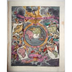
Globus Terraqueus Ecclesiastico Politicus In Suas Partes et Dominia Divisus.
This decorative print shows the hand of God holding the world suspended through a cross fixed on the North Pole. The surrounding skies are populated with cherubs, some of...
Place & Date: Munich, 1702
Selling price: $400
Sold in 2021
Carte Generale de Toutes les Costes du Monde..
Third revised state. Mortier\'s world map of 1693 was re-engraved in 1703 by Baltasar Ruyter on a larger scale. Ruyter\'s version includes numerous changes, north-east As...
Place & Date: Amsterdam, 1703
Selling price: $3200
Sold in 2008