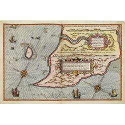
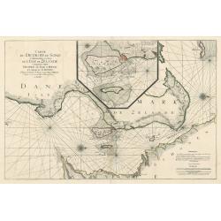
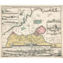
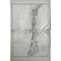
Beschrivingee der zijden op de Belt en Noortzee. . .
A rare Dutch text edition of this early detailed chart of the coast of Jutland and its towns Skagen among others. Decorated by a title and scale cartouche, two compass ro...
Place & Date: Leiden, Plantijn, 1585
Selling price: $1800
Sold in 2022
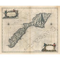
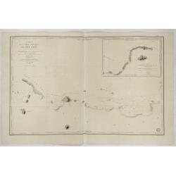
Insula Quae a Ioanne Mayen Nomen Sortita Est.
This remarkable map by Johannes Blaeu depicts the island of Jan Mayen, upon which is located the northernmost volcano on planet Earth, Beerenberg. It is a small island in...
Place & Date: Amsterdam 1659
Selling price: $200
Sold in 2023
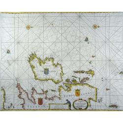
Paskaarte om achter Yrlandt om te zeylen, van Hitlandt tot aen Heyssat
Rare sea chart (the north is to the right) from the British Isles, with coats of arms of Ireland, England and Scotland.Published by H. Doncker in Amsterdam in 1664. This ...
Place & Date: Amsterdam, 1664
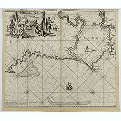
Nieuwe Paskaert, van de Kust van Genehoa als Mede een Gedeelte van Gambia, Beginnende an C. Blanco tot C. Verde…
This sea chart covers the western coast of Africa from Cape Blanco (Ras Nouadhibou) to Cape Verde. The chart depicts the interior course of both the Gambia and Casamance ...
Place & Date: Amsterdam, ca.1681
Selling price: $190
Sold in 2023
Carte des Entrees du Suyder Zee et de l'Embs... entre la Hollande et la Frise. . .
Full title at bottom right: 'Carte des Entrees du Suyder Zee et de L’Embs avec les Isles Bancs et Costes Comprises entre La Hollande et la Frise Orientale' From: Pierre...
Place & Date: Amsterdam, 1693
Selling price: $600
Sold in 2022
Carte Particuliere des Costes de Normandie
This is an original, uncolored sea chart of the coast of Normandy, France and the islands of Jersey Guernsey (Grenezey), and Alderny (Aurigny) that reside within the Engl...
Place & Date: Paris 1693
Selling price: $400
Sold in 2023
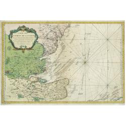
Carte de Detroit du Sond Contenant les Costes de L'Isle de Zélande Comprises ente Nicopen et L'Isle de Meun, et Celles du Schonen Depuis la Pointe de Kol, jusqu'a Valsterbon.
This is a lovely nautical chart of the sound between Sweden and Denmark produced during the golden age of map making. This sea chart was part of Pierre Mortier's 'Le Nept...
Place & Date: Amsterdam 1693
Selling price: $425
Sold in 2023
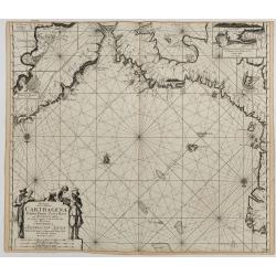
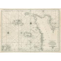
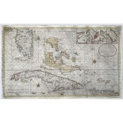
Pas-kaart van de Zee Kusten van Carthagena Tierra Firma, Costa Rica, ende Honduras…
A nautical showing the Caribbean coast, with Panama, Northern Colombia, Costa Rica to Cartagena. Includes four insets: Port of Carthagena; S. Barnardo Islands; port of No...
Place & Date: Amsterdam, J. van Keulen, 1697-1709
Selling price: $325
Sold in 2023
Copenhagen
This map by Johann Homann depicts the city of Copenhagen and its environs from differing perspectives, as the city appeared in the early 18th century.There is evidence of...
Place & Date: Nuremberg, 1720
Selling price: $300
Sold in 2023
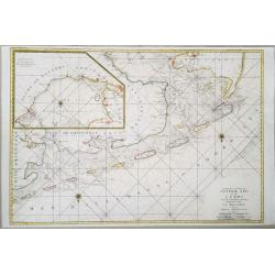
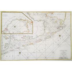
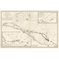
Nieuwe en Naeukeurige Afteekening vant Canaal van Bahama... / Nouvelle Carte Marine du Canal de Bahama...
Large size nautical sea chart of the Florida peninsula, Bahamas, Cuba and Hispaniola. Printed on two sheets, joined.Southern Florida and the Keys are depicted with great ...
Place & Date: Amsterdam, 1728
Selling price: $2000
Sold in 2022
Carte des Entrees du Suyder-Zee et de lEmbs ... entre la Hollande et la Frise Orientale
A highly detailed, and large format chart of the entrance to the Zuyder Zee, with in the top left corner an inset chart of the Zee 'after l'Isle D'Urck from Amsterdam&quo...
Place & Date: Paris, 1753
Carte Des Entrees De La Tamise
This is a beautiful antique nautical chart of the east coast of England, focusing on the counties of Suffolk Kent and Essex as well as the entrance to the Thames River. T...
Place & Date: Paris, 1769
Selling price: $200
Sold in 2023
Cotes de France, départements du Pas de Calais et de la Somme
A large size sea chart of the French coast from Calais to the mouth of the Somme river. Full title at bottom right: 'Cotes de France, départements du Pas de Calais et de...
Place & Date: Paris, 1792
Carte Reduite d’une partie du Vieux Canal de Bahama...
This large highly detailed chart of the northern coastline of Cuba and part of the Bahamas was published under the auspices of the Contra-Amiral Decres Ministre de la Mar...
Place & Date: Paris, 1801
Selling price: $300
Sold in 2023
![[Majorca and on verso part of the coast of Algeria.] Carte réduite de l'Isle Majorque levée parTofino. . .](/uploads/cache/48547-250x250.jpg)
[Majorca and on verso part of the coast of Algeria.] Carte réduite de l'Isle Majorque levée parTofino. . .
An extremely rare large-scale French nautical chart detailing the Balearic Island of Mallorca (Majorca). The map covers Mallorca in full inclusive of the adjacent island ...
Place & Date: Toulon, 1834
Carte de la Partie Nord-Ouest de' l'Ile de Java. . . Pl. 33. N° 1086.
Sea chart depicting the north west part of the Island of Java, up to Batavia (present-day Jakarta). Also an inset chart of part of the Java coast line.Prepared by Clémen...
Place & Date: Paris, 1839
Selling price: $500
Sold in 2022