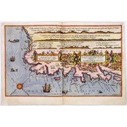
Die zee custe van Noorweghen tusschen der Noess en Mardou. . .
A rare Dutch text edition of this early and detailed chart of the coast of Norway. Decorated by a colorful title cartouche and scale cartouche, one compass rose, several ...
Date: Leiden, Plantijn, 1585
Selling price: ????
Please login to see price!
Sold in 2024
The third Dutch artic voyage by W.Barentsz.
Desirable scene during the third Dutch arctic voyage in order to find the north-east passage to India.Barentsz made three voyages (1594, 1595, 1596-1597) in search of the...
Date: Frankfurt, 1601
Selling price: ????
Please login to see price!
Sold

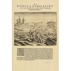
The third Dutch artic voyage by W.Barentsz.
This famous and desirable scene showing the "Behouden Huys" during the third Dutch arctic voyage in order to find the north-east passage to India.Barentsz made ...
Date: Frankfurt, 1601
Selling price: ????
Please login to see price!
Sold in 2010

Pascarte van Europa Beginnende vande Canael tot aen Spitbergen, en van Ysland tot aen Nova Zemla . . .
An eye-catching chart of northern Europe with a coastline from northern Russia to the Dutch English Channel in the south. Good detail on Iceland. North to the top.In the ...
Date: Amsterdam, after 1666
Selling price: ????
Please login to see price!
Sold in 2025

Pascaerte vande Vlaemsche, Soute, en Caribesche Eylanden, als mede Terra Nova,. . .
This fine and scarce sea chart covers the central Atlantic and extends to include the Maritime Provinces, Antilles and the northwest coast of South America, east to the A...
Date: Amsterdam, 1672
Selling price: ????
Please login to see price!
Sold in 2024
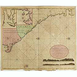
Nieuwe Paskaert van de Custen Zee Loango en Angoy van C. de Lopo Gonzalves tot R. de Zaire os Congo vertoonende alle desselfs gelegenteden.
Sea-chart of the coast of Gabon, Loango, Angoy and Angola to Zaire (Congo) River. In lower right side title and two coastal profiles. In upper left corner inset charts of...
Date: Amsterdam, ca. 1715 -1751
Selling price: ????
Please login to see price!
Sold in 2025
