Browse Listings in Maritime
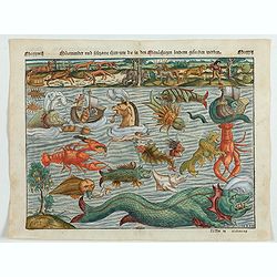
Meerwunder und Seltzame Thier.
A fine detailed woodcut depicting a superb variety of fantastic sea-monsters, such as might be encountered by a sailor in northern waters. Including monsters with abundan...
- $1950 / ≈ €1825
Place & Date: Basel, 1580
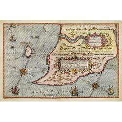
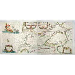
Beschrivingee der zijden op de Belt en Noortzee. . .
A rare Dutch text edition of this early detailed chart of the coast of Jutland and its towns Skagen among others. Decorated by a title and scale cartouche, two compass ro...
Place & Date: Leiden, Plantijn, 1585
Selling price: $1800
Sold in 2022
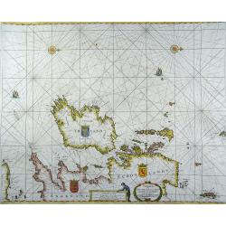
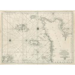
Insula D. Helenae sacra coeli dementia et aequabilitate . . .
From Linschoten, Itinerario. 3 Renaissance cartouches, 1 compass rose and many sailig ships. -
Place & Date: Amsterdam, 1589
![Pisces in mari alati [flying fish attack]](/uploads/cache/48527-250x250.jpg)
Pisces in mari alati [flying fish attack]
Flying fish attacking a Portuguese ship in the West Indian Waters.Read more about "Les Grand Voyages" by Theodore De Bry [+]
- $400 / ≈ €374
Place & Date: Frankfurt, 1594
![[Columbus is standing in the bow of his ship]](/uploads/cache/48524-250x250.jpg)
[Columbus is standing in the bow of his ship]
Columbus is standing in the bow of his ship, which is near the shore. He is clad in a long mantle and undercoat, while his armor lies at his feet, and his standard is flo...
- $750 / ≈ €702
Place & Date: Frankfurt, 1594
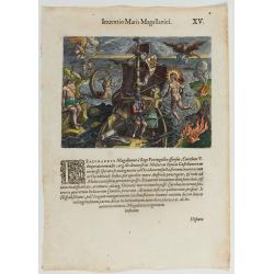
Inventio Maris Magallanici.
Allegorical scene allegorical image celebrating the circumnavigation of the earth by Ferdinand Magellan. The image shows Magellan on board of his ship, surrounded by myth...
- $750 / ≈ €702
Place & Date: Frankfurt, 1594
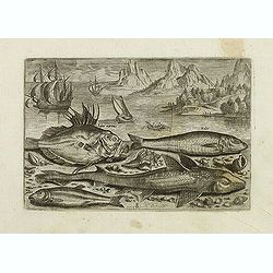
Faber marinus, Halee, Gabio, Acipenser Zeelandicus. (Piscium Vivæ Icones - Fish)
Depiction of Faber marinus, Halee, Gabio, Acipenser Zeelandicus. Set against a mountainous landscape in the manner of Pieter Brueghel the Elder. Plate number 8. The engra...
Place & Date: Antwerp, after 1598
Selling price: $150
Sold in 2023
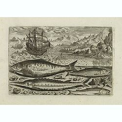
Alosa, Acipenser, Manula, Apua cobitis, (Piscium Vivæ Icones - Fish)
Depiction of Alosa, Acipenser, Manula, Apua cobitis, set against a mountainous landscape in the manner of Pieter Brueghel the Elder. Plate number 10. The engraving is cop...
Place & Date: Antwerp, after 1598
Selling price: $150
Sold in 2023
The third Dutch artic voyage by W.Barentsz.
Desirable scene during the third Dutch arctic voyage in order to find the north-east passage to India.Barentsz made three voyages (1594, 1595, 1596-1597) in search of the...
Place & Date: Frankfurt, 1601
Selling price: $120
Sold

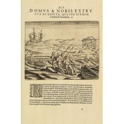
The third Dutch artic voyage by W.Barentsz.
This famous and desirable scene showing the "Behouden Huys" during the third Dutch arctic voyage in order to find the north-east passage to India.Barentsz made ...
Place & Date: Frankfurt, 1601
Selling price: $150
Sold in 2010
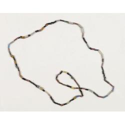
Dutch Trade Bead.
An extremely rare necklace made from authentic early 17th-century glass beads produced in the Netherlands. This rare and early Dutch Trade bead is built up from irregular...
Place & Date: Middelburg, before 1623
Selling price: $2200
Sold in 2023
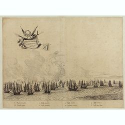
Quartum Praelium Coniovian inter et Fluvium Rio Grande XVII Ian
Decorative engraving of the fourth sea battle with the Portuguese fleet offshore at the Rio Grande, in1640. Engraved by J. van Brosterhuyzen after a design by Frans J. Po...
- $500 / ≈ €468
Place & Date: Joannes Blaeu, Amsterdam 1647
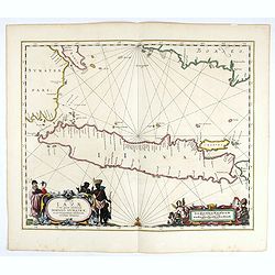
Insulae Iavae Cum parte insularum Borneo Sumatrae..
An elegant sea chart of the island of Java with parts of Sumatra, Borneo and Bali. The map includes only coastal detail and shows the Dutch capital in the East Indies at ...
Place & Date: Amsterdam, 1652
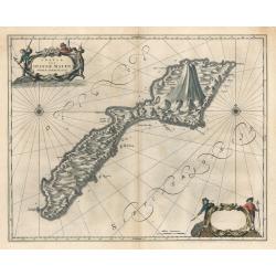
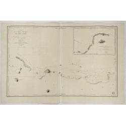
Insula Quae a Ioanne Mayen Nomen Sortita Est.
This remarkable map by Johannes Blaeu depicts the island of Jan Mayen, upon which is located the northernmost volcano on planet Earth, Beerenberg. It is a small island in...
Place & Date: Amsterdam 1659
Selling price: $200
Sold in 2023
Paskaarte om achter Yrlandt om te zeylen, van Hitlandt tot aen Heyssat
Rare sea chart (the north is to the right) from the British Isles, with coats of arms of Ireland, England and Scotland.Published by H. Doncker in Amsterdam in 1664. This ...
Place & Date: Amsterdam, 1664
Paskaerte van het inkoomen van de MAES, Tot aen 't Eylandt Roosenburgh als mede 't Inkoomen van 't Goereesche Gat.. / Pascaert van 't Eylandt Roosenburg door de Oude en Nieuwe Maes....
A very attractive sea chart on two sheets of the mouth of the river Maas. The left sheet shows Dordrecht, Rotterdam and the fortress at Willemstad. Rghthand sheet dep...
Place & Date: Amsterdam, 1680
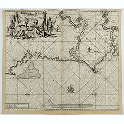
Nieuwe Paskaert, van de Kust van Genehoa als Mede een Gedeelte van Gambia, Beginnende an C. Blanco tot C. Verde…
This sea chart covers the western coast of Africa from Cape Blanco (Ras Nouadhibou) to Cape Verde. The chart depicts the interior course of both the Gambia and Casamance ...
Place & Date: Amsterdam, ca.1681
Selling price: $190
Sold in 2023

Paskaart van de kust van Maroca beginnende van Larache tot aan C. Cantin. . .
A nautical sea chart of the coast of Morocco. Insert at top right: 'Nieuwe Afbeelding van de Rivier Rio Rebata in 't Groot".Bottom right: chart number '32'. Compass ...
Place & Date: Amsterdam, ca.1682
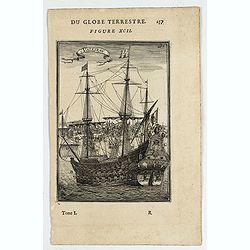
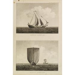
Vaisseau.
Miniature view of a vessel, showing its various corposants. With key list on verso.From the French text edition of Description d'Univers.. (5 volumes), 1683. By Allain Ma...
- $80 / ≈ €75
Place & Date: Paris, 1683
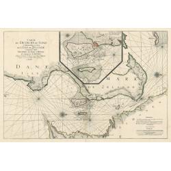
Carte de Detroit du Sond Contenant les Costes de L'Isle de Zélande Comprises ente Nicopen et L'Isle de Meun, et Celles du Schonen Depuis la Pointe de Kol, jusqu'a Valsterbon.
This is a lovely nautical chart of the sound between Sweden and Denmark produced during the golden age of map making. This sea chart was part of Pierre Mortier's 'Le Nept...
Place & Date: Amsterdam 1693
Selling price: $425
Sold in 2023
Carte Particuliere des Costes de Normandie
This is an original, uncolored sea chart of the coast of Normandy, France and the islands of Jersey Guernsey (Grenezey), and Alderny (Aurigny) that reside within the Engl...
Place & Date: Paris 1693
Selling price: $400
Sold in 2023
Carte des Entrees du Suyder Zee et de l'Embs... entre la Hollande et la Frise. . .
Full title at bottom right: 'Carte des Entrees du Suyder Zee et de L’Embs avec les Isles Bancs et Costes Comprises entre La Hollande et la Frise Orientale' From: Pierre...
Place & Date: Amsterdam, 1693
Selling price: $600
Sold in 2022
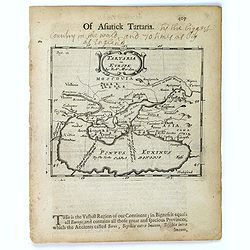
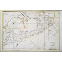
Tartaria in Europe.
This map appeared in Modern's rare 'Atlas Terestris', first published in 1687, depicting the regions surrounding the Black Sea.It features a pleasant scrolled title carto...
Place & Date: London, 1700
Selling price: $110
Sold in 2016
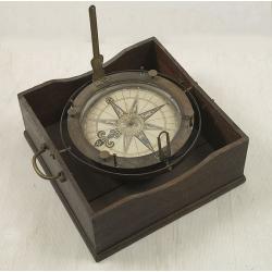
Important early azimuth compass.
The gimballed and weighted brass compass bowl has a removable glazed cover, mounted with folding brass sight vanes, four unusually turned brass capstan posts to support d...
Place & Date: Dutch, c 1700
Selling price: $24000
Sold

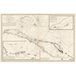
Pas kaart vande Zuyd kust van Cuba en van Geheel Jamaica…
A nautical chart covering the southern part of Cuba, all of Jamaica and the western tip of Hispaniola and a bit of the Honduras coastline. Insets of "Baya Oristan in...
Place & Date: Amsterdam, J. van Keulen, 1697-1709
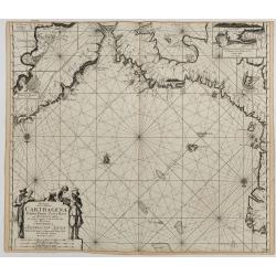
Pas-kaart van de Zee Kusten van Carthagena Tierra Firma, Costa Rica, ende Honduras…
A nautical showing the Caribbean coast, with Panama, Northern Colombia, Costa Rica to Cartagena. Includes four insets: Port of Carthagena; S. Barnardo Islands; port of No...
Place & Date: Amsterdam, J. van Keulen, 1697-1709
Selling price: $325
Sold in 2023
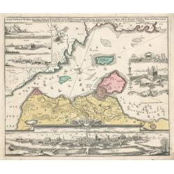
Copenhagen
This map by Johann Homann depicts the city of Copenhagen and its environs from differing perspectives, as the city appeared in the early 18th century.There is evidence of...
Place & Date: Nuremberg, 1720
Selling price: $300
Sold in 2023
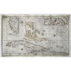
Nieuwe en Naeukeurige Afteekening vant Canaal van Bahama... / Nouvelle Carte Marine du Canal de Bahama...
Large size nautical sea chart of the Florida peninsula, Bahamas, Cuba and Hispaniola. Printed on two sheets, joined.Southern Florida and the Keys are depicted with great ...
Place & Date: Amsterdam, 1728
Selling price: $2000
Sold in 2022
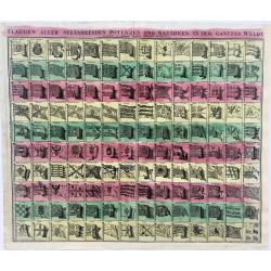
Flaggen aller Seefahrenden Potenzen und Noationen in der gantzen Welt...
Striking example of the famous Flag print produced by Homann. The chart illustrates 139 flags of various nations, factions, and trading companies, including the flags of ...
Place & Date: Nurenberg, 1730
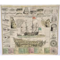
Neue Tafel, vor alle Liebhabers, und See-fahrende Personen. Stellet vor ein Orlog oder Kriegs=Schiff, mit seinen Völligen Tow oder Seil Werk auch Vor und Hindertheil
Extremely decorative, large print showing the details of war ships of the time. Note the nice original colors.
Place & Date: Nurenberg, 1730
Selling price: $620
Sold in 2023
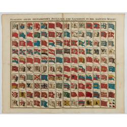
Flaggen aller seefahrenden potenzen und nationen…
A highly decorative and beautiful print with 139 flags of the sea-faring nations, factions, and trading companies. Among the more interesting flags are those of the Dutch...
Place & Date: Nuremberg, 1750
Carte des Entrees du Suyder-Zee et de lEmbs ... entre la Hollande et la Frise Orientale
A highly detailed, and large format chart of the entrance to the Zuyder Zee, with in the top left corner an inset chart of the Zee 'after l'Isle D'Urck from Amsterdam&quo...
Place & Date: Paris, 1753
Carte Des Entrees De La Tamise
This is a beautiful antique nautical chart of the east coast of England, focusing on the counties of Suffolk Kent and Essex as well as the entrance to the Thames River. T...
Place & Date: Paris, 1769
Selling price: $200
Sold in 2023
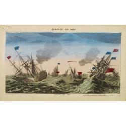
Tempête sur Mer.
So-called optical print. Showing a English and French ships at rough sea. Mondhare was one of the well-known publishers of optical prints, established in Paris.In the eig...
Place & Date: Paris, 1780
Selling price: $200
Sold in 2022
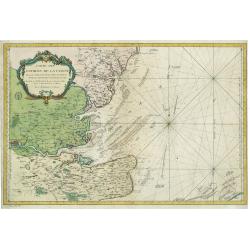
Cotes de France, départements du Pas de Calais et de la Somme
A large size sea chart of the French coast from Calais to the mouth of the Somme river. Full title at bottom right: 'Cotes de France, départements du Pas de Calais et de...
Place & Date: Paris, 1792
Carte Reduite d’une partie du Vieux Canal de Bahama...
This large highly detailed chart of the northern coastline of Cuba and part of the Bahamas was published under the auspices of the Contra-Amiral Decres Ministre de la Mar...
Place & Date: Paris, 1801
Selling price: $300
Sold in 2023
Bateau Japonais. Two prints on one sheet.
Engraving of 18th century Japanese boat drawn by Lt. Blondela. Done during the expedition of comte de Jean-Francois de Galaup La Perouse in the Pacific Ocean in 1785-1788...
Place & Date: Paris, 1812
Selling price: $100
Sold in 2023
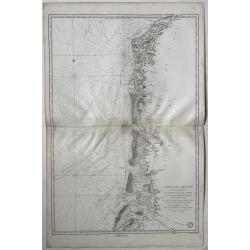
![[Majorca and on verso part of the coast of Algeria.] Carte réduite de l'Isle Majorque levée parTofino. . .](/uploads/cache/48547-250x250.jpg)
[Majorca and on verso part of the coast of Algeria.] Carte réduite de l'Isle Majorque levée parTofino. . .
An extremely rare large-scale French nautical chart detailing the Balearic Island of Mallorca (Majorca). The map covers Mallorca in full inclusive of the adjacent island ...
Place & Date: Toulon, 1834
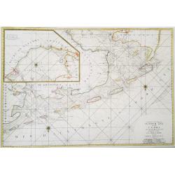
Carte de la Partie Nord-Ouest de' l'Ile de Java. . . Pl. 33. N° 1086.
Sea chart depicting the north west part of the Island of Java, up to Batavia (present-day Jakarta). Also an inset chart of part of the Java coast line.Prepared by Clémen...
Place & Date: Paris, 1839
Selling price: $500
Sold in 2022
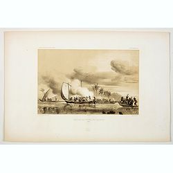
Agression des Naturels des Iles Opoulou.
A lithograph print of a confrontation between French sailors from the ships 'Astrolabe' & 'Zelle'' , under the command of Durmont D'Urville, in New Zealand waters, wi...
Place & Date: Paris, 1846
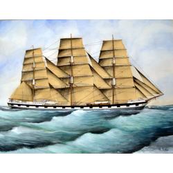
Original Maritime painting of the 'Cape Horn' , a so-called captain's ship drawing by R. Takes
A fine example of a so-called 'captain's portrait' of a clipper-ship under full sail.The name of the ship at the bow reads "Cape Horn" Signed in the lower right...
Place & Date: c. 1850
![[Lot of 7 Maritime prints] Deutschland zur See 1902](/uploads/cache/IMG_2535-250x250.jpg)
[Lot of 7 Maritime prints] Deutschland zur See 1902
[Lot of 7 prints] of pre-World War I ships of the German Navy.Deutschland zur See 1902- S. M. Uebungsgeschwader "Victoria Louise" und "Kurfürst Friedric...
Place & Date: 1896
-250x250.jpg)
Original Painting: English battleship of the line.
A very fine mono watercouler, signed Hans Bohrdt, being a very dramatic scene of an English man-of-war sailing in battle line torpedoed by a German U-boat, on the left,...
Place & Date: c. 1915
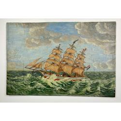
Painting made by a sailor, signed W.Welman.
Original Panel from a thee-box, with a painting of a ship. Signed in lower right "Hr. W. Welman". Complete with a naive painting of a square-rigged sailing...
Place & Date: circa. 1960