Browse Listings in Europe > Portugal > Portugal Provinces
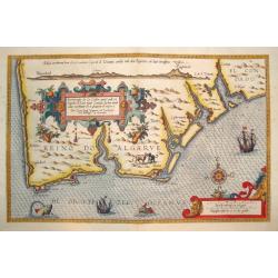
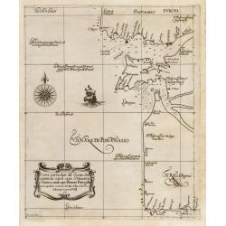
BESCHRIJUINGHE DER ZEE CUFTEN VANT LANT...ARGARBE...
A rarely seen, beautifully rendered and highly decorative sea chart of the Algarve, located in the far south of Portugal.Published in the important 1584 edition of SPIEGE...
Date: Leyden, 1584
Selling price: ????
Please login to see price!
Sold
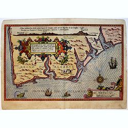
Beschrijvinghe der Zee Custen vant Landt va Argarbe ..
A fine and rare historical maritime map of southern Portugal (Reino do Algarve). Decorated by a colorful title cartouche and scale cartouche, one compass rose, several ve...
Date: Leiden, Plantijn, 1584-1586
Selling price: ????
Please login to see price!
Sold in 2019
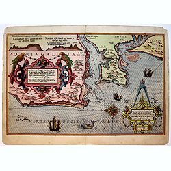
Zee Caerte van Portugal, Daer inne Begrepen de vermaerde Coopstadt van Lisbone ..
A very rare and exquisite maritime map of a part of Portugal including Lisbon. Decorated by a colorful title cartouche and scale cartouche, one compass rose, several vess...
Date: Leiden, Plantijn, 1584-1586
Selling price: ????
Please login to see price!
Sold in 2019
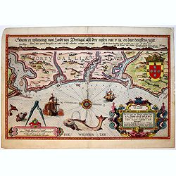
Die Zee Caerte van Portugal, tusschen Camino en Montego, alsoe dat Landt all daer in sijn Ghedaente is, met alle sijne haeven enn ondiepten ...
A fine and very rare maritime map with detailed description of part of Portugal. Decorated by a colorful title cartouche and scale cartouche, one compass rose, several ve...
Date: Leiden, Plantijn, 1584-1586
Selling price: ????
Please login to see price!
Sold in 2019
![[Lot of 4 map western Spain / Portugal Antique map of Galicia] Gallaecia Regnum, descripta a F. Fer. Ojea.](/uploads/cache/20886-(2)-250x250.jpg)
[Lot of 4 map western Spain / Portugal Antique map of Galicia] Gallaecia Regnum, descripta a F. Fer. Ojea.
A map of Galicia after Ferdinand Ajea’s map ‘Reyno de Galizia of 1598. Decorated with two cartouches, ships and wind-roses. Dutch text on verso.Willem Blaeu, fath...
Date: Amsterdam, 1635
Selling price: ????
Please login to see price!
Sold in 2023
Carta particolare del Oceano che comincia con il capo S. Vincentio...
A fine example of Sir Robert Dudley's nautical chart of Portugal that encompass the coast from Lisbon south to Lagos. The map was part of Dell' Arcano Del Mare (Mysteries...
Date: Florence, 1646
Selling price: ????
Please login to see price!
Sold in 2023
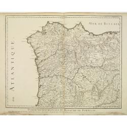
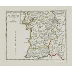
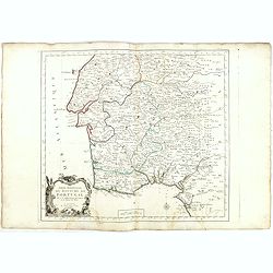
Partie Septentrionale du Royaume de Portugal.
Detailed map of the northern part of Portugal and the northern tip of Morocco. Complementing with lot 08314.
Date: Paris, 1711
Selling price: ????
Please login to see price!
Sold in 2011
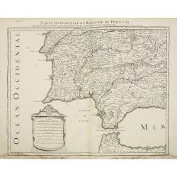
Partie Meridionale du Royaume de Portugal. . .
Detailed map of the southern part of Portugal and the northern tip of Morocco. Fine-scale cartouche. Complementing with lot 08315.
Date: Paris, 1711
Selling price: ????
Please login to see price!
Sold in 2011
Partie Septentrionale du Royaume de Portugal.
Small detailed map encompassing the whole northern half of Portugal. From Atlas Portatif Universel, by Robert de Vaugondy.Page 50 outside border top right. Mary Sponberg ...
Date: Paris, later than 1749
Selling price: ????
Please login to see price!
Sold in 2012
Partie Meridionale du Royaume de Portugal.
Small detailed map encompassing the whole southern half of Portugal. From Atlas Portatif Universel, by Robert de Vaugondy.Page 51 outside border top right. Mary Sponberg ...
Date: Paris, later than 1749
Selling price: ????
Please login to see price!
Sold in 2012
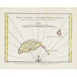
Carte des Isles de Madere et Porto Santo.
An uncommon issue of this very nice map of the Island of Madera and Porto Santo.With French text in title cartouche and an additional title in Dutch underneath the map.
Date: Amsterdam, 1773
Selling price: ????
Please login to see price!
Sold
L'Estremadura di Portogallo Alentejo, ed Algarve. . .
Map of the regions of Algarve and Alentejo of Southwestern Portugal by Antonio Zatta. The city of Lisbon is depicted along the western coast, as are the other towns, vill...
Date: Venice, 1775
Selling price: ????
Please login to see price!
Sold in 2010
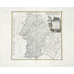
Il Portogallo Cioe le Provincie di Entredouro, e Minho, Traz-os-Montes, e Beira Di Nuova Projezione. . .
Map of the provinces of Minho, Biera, Tras-os-Montes e Alto Duoro and Beira, of northern Portugal, by Antonio Zatta. Towns, villages, forests, mountains and rivers of the...
Date: Venice, 1776
Selling price: ????
Please login to see price!
Sold in 2010
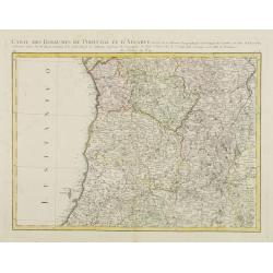
Carte des Royaumes de Portugal et D\'Algarve..
Map of the northern part of Portugal prepared by Giovanni Antonio Bartolomeo Rizzi Zannoni, one of the leading cartographers of the late 18th century, as well as being an...
Date: Paris, ca 1783
Selling price: ????
Please login to see price!
Sold in 2010
Partie Septentrionale.. Partie Meridionale du Royaume de Portugal..
A detailed map of southern part of Portugal showing the roads, prepared by N.Bellin.Venetian edition of the map by Bellin, to whom Santini gives credit in the cartouche.F...
Date: Venice, 1776 - 1784
Selling price: ????
Please login to see price!
Sold in 2015
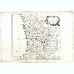
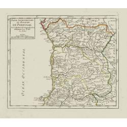
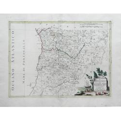
Partie Septentrionale du Royaume de Portugal. . .
Detailed map encompassing the whole northern half of Portugal, with part of the neighboring Spain.Venetian edition of the map by Bellin, to whom Santini gives credit in t...
Date: Venice, 1776 - 1784
Selling price: ????
Please login to see price!
Sold in 2022
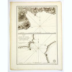
Plan de la Rade d'Angra, en L'Ile Tercere. . . / Plan de la Rade de Fayal. . .
A twin chart of the two harbours of Angra and Fayal (Faial) in the Azores, surveyed by the Depot General de la Marine in Paris towards the end of the eighteenth century. ...
Date: Paris, ca 1791
Selling price: ????
Please login to see price!
Sold in 2019
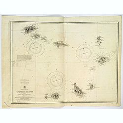
Cape Verde Islands.
A large double page sea chart of the Cape Verde Islands in the Atlantic Ocean, initially surveyed by Lieut's Vidal & Mudge, R.N. between 1819-21, and first published ...
Date: London, 1926
Selling price: ????
Please login to see price!
Sold in 2023
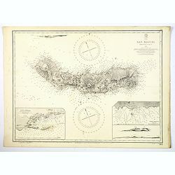
Azores. San Miguel.
A large updated sea chart of the island of San Miguel in the Azores, originally surveyed by Capt. A.T.E. Vidal, R.N. in 1844. The chart has had a few new editions, and a ...
Date: London, 1939
Selling price: ????
Please login to see price!
Sold in 2021
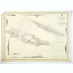
Azores. Fayal Pico and San Jorge.
A large updated sea chart of Fayal (Faial) Pico and San Jorge in the Azores Archipelago in the Atlantic Ocean, first survey in 1844 by Capt. A.T.E. Vidal, R.N. The chart ...
Date: London, 1941
Selling price: ????
Please login to see price!
Sold in 2020
