Browse Listings in Europe > Italy > General Italy
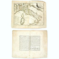
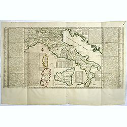
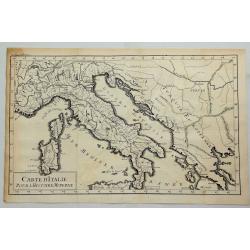
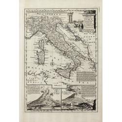
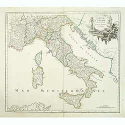
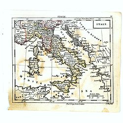
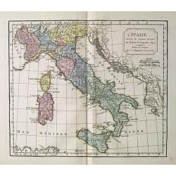
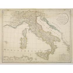
L'Italie divisée en ses principaux estats.
An interesting small map of Italy by Nicolas de Fer. From his rare "Petit et Nouveau Atlas". The first edition was published in 1697 and was republished in 1705...
Date: Paris, 1705
Selling price: ????
Please login to see price!
Sold in 2018
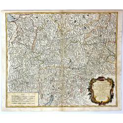
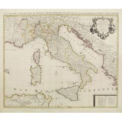
Nouvelle carte de l'Italie ou sont exactement marquez les postes et les chemins. . .
Map of Italy, with depiction of the most important post routes. To the left the islands of Corsica and Sardine. Prepared by Cantelli, Giacomo Cantelli (1643-1695). With t...
Date: Leiden, c. 1710
Selling price: ????
Please login to see price!
Sold
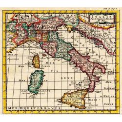
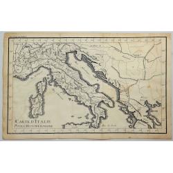
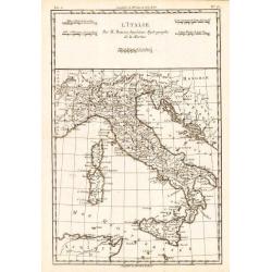
L'Italie.
Uncommon and detailed map of Italy, from Nouvelle atlas, trés-exact et fort commode pour toutes sortes de personnes, contenant les principales cartes géographiques.. .A...
Date: Leiden 1714
Selling price: ????
Please login to see price!
Sold
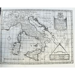
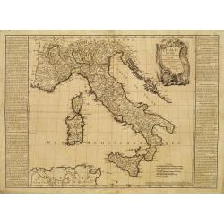
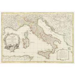
A New Map of Present Italy, together with the Adjoining Islands of Sicily, Sardinia, and Corsica. . .
A scarce copper engraved map of Italy with many places names. A legend key identifies universities. With a large title banner and a distance scale with dividers, dedicate...
Date: Oxford, ca 1701-1714
Selling price: ????
Please login to see price!
Sold in 2020
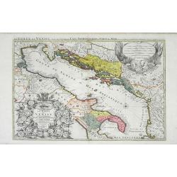
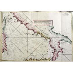
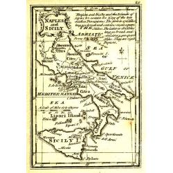
Le Golfe de Venise Avec ses Principaux Caps Promontiores & Ports de Mer. . .
Map of the Gulf of Venice also known as the Adriatic Sea by Sanson and published by Covens and Mortier. The colored areas include southern Italy to the west and Dalmatie ...
Date: Amsterdam, c. 1715
Selling price: ????
Please login to see price!
Sold in 2010
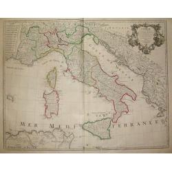
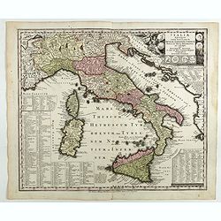
Carte Generale D'Italie Et des Isles Adjacentes..
Decorative map of Italy displaying at both sides a list containing the names of the popes. In the Tyrrhenian Sea instead, a table presents a list of the Antipopes.From Le...
Date: Paris, 1719
Selling price: ????
Please login to see price!
Sold in 2022
Carte Generale D'Italie Et des Isles Adjacentes. . .
Decorative map of Italy displaying at both sides a list containing the names of the popes. In the Tyrrhenian Sea instead, a table presents a list of the Antipopes.From Le...
Date: Paris, 1719
Selling price: ????
Please login to see price!
Sold in 2023
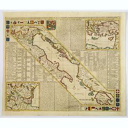
Carte de geographie des differents etats de la Republique de Venise. . .
A fine map of the Adriatic Sea and Gulf of Venice, extending until Athens and Peloponnese. It names islands such as Corfu, Kefalonia,, and many of the Croatian islands. I...
Date: Amsterdam, 1719
Selling price: ????
Please login to see price!
Sold in 2019
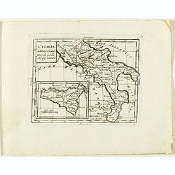
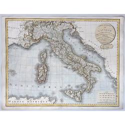
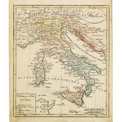
L´Italie...
Title: L´Italie. Dressée sur les Observations de Mrs. de l´Academie Royale des Sciences sur celles du R.P. Riccioli de la Compagnie de Jesus et autres Astronomes du pa...
Date: France, c. 1720
Selling price: ????
Please login to see price!
Sold in 2018
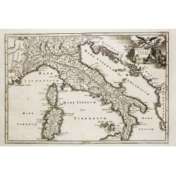
Italia Antiqua cum insulis Sicilia Sardinia..
Fine map of ancient Italy, including Sardinia and Corsica.A Amsterdam issue of the map by Nicolas Sanson.
Date: Amsterdam 1720
Selling price: ????
Please login to see price!
Sold
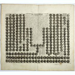
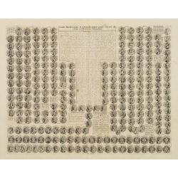
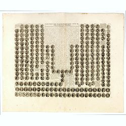
Carte historique et cronologique pour servir de suite à l' Histoire Romaine.
Interesting sheet with a small portraits of the Roman Emperors. Henri Abraham Chatelain (1684 – 1743) was a Huguenot pastor of Parisian origins. He lived consecutively ...
Date: Amsterdam, 1720
Selling price: ????
Please login to see price!
Sold in 2017
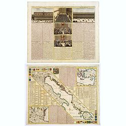
Carte de Géographie des différents Etats de la République de Venise . . .
Interesting map of the Gulf of Venice with inset map of the surroundings of Venice and map of Turkey in upper right corner. Descriptive French text, from Chatelain's monu...
Date: Amsterdam, 1720
Selling price: ????
Please login to see price!
Sold in 2017
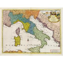
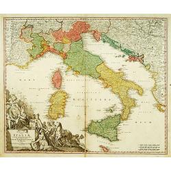
Nouvelle Carte De L'Etat Present De L'Italie Pour Parvenir par Une Methode Nouvelle A La Connoissance De La Geographie Et De L'Histoire.
Attractive and highly detailed map of Italy, colored by Kingdoms and showing Corsica, Sardinia and an inset of Sicily. Extensive text annotations on either side of this w...
Date: Amsterdam, 1720
Selling price: ????
Please login to see price!
Sold in 2021
Carte du Gouvernement Civil et Politique...Venise / Carte de geographie des Differents Etats...Venise. . .
These impressive plates and maps are a wonderful example of Chatelain’s elegant skills. Both included in the 1720 edition of theAtlas Historique, published in Amsterdam...
Date: Amsterdam, 1720
Selling price: ????
Please login to see price!
Sold in 2017
Carte Genealogique des Divinitez du Paganisme, l' Incertitude de leur Origine avec des Instructions poour conduire a la Connoissance de la Fable et a l' Histoire Ancienne et Moderne avec Diverses Observations...
Showing a genealogy of the Pagan (Roman) deities, including details of their origins. Small insets show the ancient Roman Gods such as Venus, Apollon . . .Henri Abraham C...
Date: Amsterdam, 1720
Selling price: ????
Please login to see price!
Sold in 2018

Carte genealogique des premiers rois de Naples, de Sicile et de Hongrie . . .
Genealogical chart of kings of Naples, Sicily and Hungary, from Chatelain's monumental 7 volume "Atlas Historique". Henri Abraham Chatelain (1684 – 1743) was ...
Date: Amsterdam, 1720
Selling price: ????
Please login to see price!
Sold in 2018
Carte de Géographie des différents Etats de la République de Venise . . .
An interesting map of the Gulf of Venice with inset map of the surroundings of Venice and map of Turkey in upper right corner. Plenty of descriptive French text, from Cha...
Date: Amsterdam, 1720
Selling price: ????
Please login to see price!
Sold in 2021
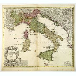
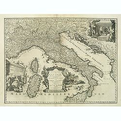
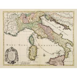
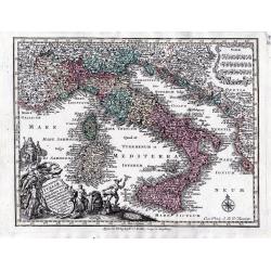
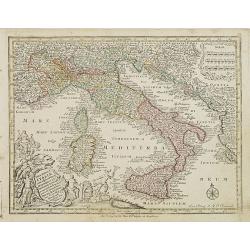
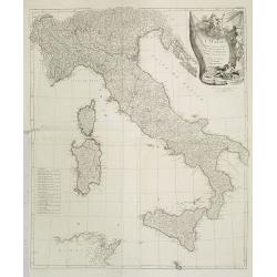
Statuum totius Italiae. . . Siciliae Sardiniae. . .
Johann Baptist Homann's well-engraved map of Italy, Sardinia, Corsica, Malta and Sicily and the western edge of the Adriatic that has an excellent large decorative cartou...
Date: Nuremberg, 1720
Selling price: ????
Please login to see price!
Sold in 2020
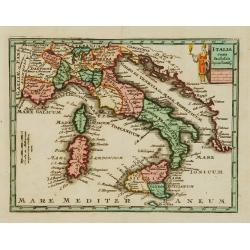
Italie.
A nice little map of Italy.
Date: Amsterdam, 1721
Selling price: ????
Please login to see price!
Sold
Italia cum Insulis..
Uncommon map of Italy. The originally colored title cartouche is surrounded by mythological figures. From Atlas Portatif.
Date: Nuremberg 1724
Selling price: ????
Please login to see price!
Sold
Carte historique et chronologique pour servir de suite a l histoire Romaine. . .
Extremely interesting sheet with a small portraits of the Roman Emperors.From: Atlas Historique.
Date: Amsterdam, 1728
Selling price: ????
Please login to see price!
Sold in 2008
Carte historique et chronologique pour servir de suite a l histoire Romaine. . .
Extremely interesting sheet with a small portraits of the Roman Emperors.From: Atlas Historique.More about Chatelain Atlas. [+]
Date: Amsterdam, 1728
Selling price: ????
Please login to see price!
Sold in 2016
Carte D'Italie pour L'Histoire Moderne.
A striking map of Italy and European Turkey from the “METHODE POUR ETUDIER L’HISTOIRE” by L’Abbe Lenglet du Fresnoy, published in Paris in 1729. The map is quite ...
Date: Paris, 1729
Selling price: ????
Please login to see price!
Sold in 2019
Carte D'Italie Pour L'Histoire Romaine.
A striking map of Italy shown at the time of the Romans from the “METHODE POUR ETUDIER L’HISTOIRE” by L’Abbe Lenglet du Fresnoy, published in Paris in 1729. The m...
Date: Paris, 1729
Selling price: ????
Please login to see price!
Sold in 2023
Italiae antique item insularum Siciliae, Sardiniae, Corsica . . .
Map of ancient Italy.Matthaus Seutter the elder first published his "Atlas Geographicus" in 1720 and added to the contents in subsequent editions under the titl...
Date: Augsburg, 1730
Selling price: ????
Please login to see price!
Sold in 2018
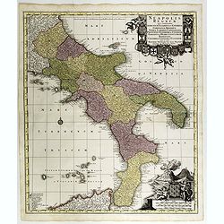
Neapolis Regnum . . .
Map of the region from Naples to Calabria. Cartouche representing Vesuvius erupting.Matthaus Seutter the elder first published his "Atlas Geographicus" in 1720 ...
Date: Ausburg, 1730
Selling price: ????
Please login to see price!
Sold in 2017
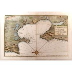
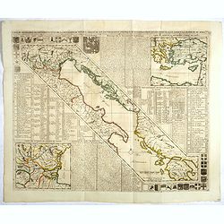
Plan de la Baye de Loristan
Nautical chart of the Gulf of Oristano in Sardinia. Decorated with a formidable compass rose, pointing due left. Little is known about Jacques Ayrouard and he only publi...
Date: Paris, 1732
Selling price: ????
Please login to see price!
Sold in 2014
Statuum totius Italiae.. Siciliae Sardiniae..
Johann Baptist Homann's well-engraved map of Italy, Sardinia, Corsica, Malta and Sicily has a large decorative cartouche with portrait of Pope Clemens XI..Johann Baptist ...
Date: Nuremberg 1740
Selling price: ????
Please login to see price!
Sold
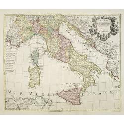
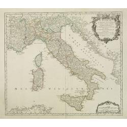
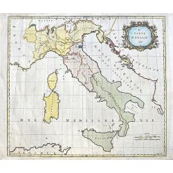
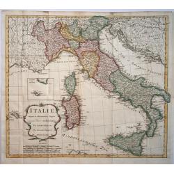
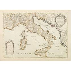
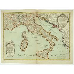
L' Italie, Dressee sur les Observations de Mrs. De L' Academie Royale des Sciences..
A decorative map of Italy, including Sicily, Sardinia, Corsica, part of the Mediterranean Sea, and portions of the neighboring countries of Slovenia, Albania, Montenegro,...
Date: Amsterdam, c. 1744
Selling price: ????
Please login to see price!
Sold in 2009
Nova Totius Italiae cum adjacentibus majoribus et minorib insulis tabula …
A detailed map of Italy and the islands of Corsica, Sardinia and Sicily together with its possessions along the Dalmatian coastFrom: Atlas Minor Praecipua Orbis Terrarum ...
Date: Augsburg, circa 1744
Selling price: ????
Please login to see price!
Sold in 2023
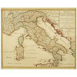
Tabula Italiae Antiquae..
Very decorative map of the Italian peninsula.The map is from a Dutch edition of De L'Isle's work entitled, Atlas Nouveau, Contenant Toutes Les Parties Du Monde, Ou sont e...
Date: Amsterdam c. 1745
Selling price: ????
Please login to see price!
Sold
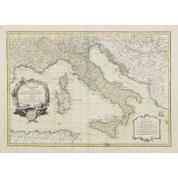
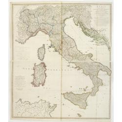
L' Italie, Dressee sur les Observations de Mrs. De L' Academie Royale des Sciences..
A large, highly detailed map of the Italian peninsula and the surrounding parts of France and the Balkans. Includes Sardinia and Corsica. Decorated with a fine title cart...
Date: Amsterdam c. 1745
Selling price: ????
Please login to see price!
Sold
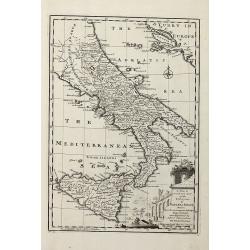
A New & Accurate Map of the Kingdoms of Naples & Sicily
Decorative engraved map of South Italy by Bowen from 'A Complete System of Geography'. Showing the southern part of Italy with Sicily. With one decorative cartouche, a co...
Date: London, 1747
Selling price: ????
Please login to see price!
Sold in 2011
A New and Accurate Map of Italy Drawn from the Latest and Best Authorities, and Regulated by the Most Approved Astronl. Observations
Decorative engraved map of Italy by Bowen from 'A Complete System of Geography'. Below with to inset views of Mount Vesuvius eruptions. With one decorative cartouche, a c...
Date: London, 1747
Selling price: ????
Please login to see price!
Sold in 2013
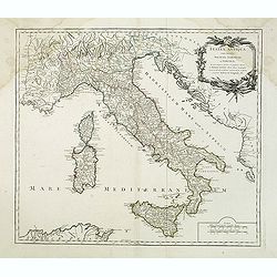
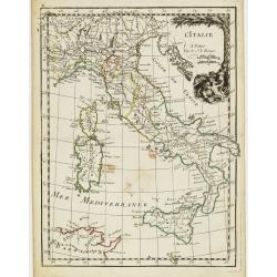
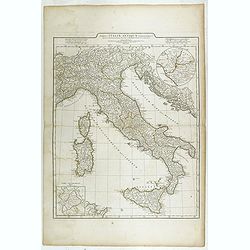
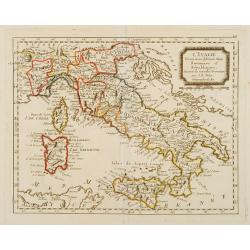
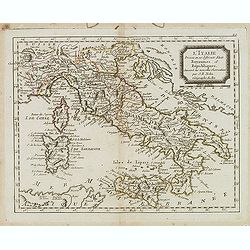
L'Italie qui comprend les états de Piémont. . .
Detailled map of Italy, including the island of Corsica, Sardaigna and Sicily from his "Atlas Universel".Gilles Robert de Vaugondy (1688–1766), also known as ...
Date: Paris, 1750
Selling price: ????
Please login to see price!
Sold in 2018
Italia antiqua cum insulius Sicilia, Sardinia et Corsica. . .
Map of Italy, including the islands of Corsica, Sardinia and Sicilia. Published by Robert Vaugondy (son 1723-1886) after a map by Nicolas Sanson.Map shows the ancient div...
Date: Paris, c.1751
Selling price: ????
Please login to see price!
Sold in 2010
Italia antiqua cum insulius Sicilia, Sardinia et Corsica. . .
Map of Italy, including the islands of Corsica, Sardinia and Sicilia. Published by Robert Vaugondy (son 1723-1886) after a map by Nicolas Sanson. Map shows the ancient di...
Date: Paris, c.1751
Selling price: ????
Please login to see price!
Sold in 2014
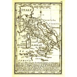
Le Tyrol Sous le Nom Duquel L'On Comprend le Comte de Tyrol
A scarce map of the county of Tyrol in modern day Italy and Austria, It covers this historic region from Lake Constance east to Lienz, Austria, and south as far as Lake G...
Date: Paris, 1753
Selling price: ????
Please login to see price!
Sold in 2016
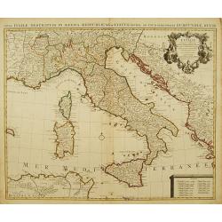
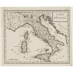
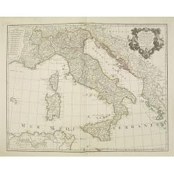
L'Italie Divisée en tous ses Estats..
RARE map of Italy prepared by J.B.Nolin and published by Daumont. A visually stunning map with a large title cartouche.To the left and right text boxes with a geographica...
Date: Paris 1755
Selling price: ????
Please login to see price!
Sold
2e. Carte D'Italie 1755.
A curious map of Italy by Thomas Kitchin. Only a few major cities and rivers are named. Also the Vesuv and Etna volcanoes are shown. With a large decorative title cartouc...
Date: London, 1755
Selling price: ????
Please login to see price!
Sold in 2020
L' Italie.
Fine map of Italy with decorative title cartouche. With date 1743 added in manuscript.George Louis Le Rouge was active from 1740- till 1780 as a publisher, and was appoin...
Date: Paris, 1756
Selling price: ????
Please login to see price!
Sold in 2020
Carte de l'Italie dans laquelle sont tracées les routes des postes.
post road maps map of Italy, including the island of Corsica, Sardine and Sicilia from his "Atlas Universel".Gilles Robert de Vaugondy (1688–1766), also known...
Date: Paris, 1756
Selling price: ????
Please login to see price!
Sold in 2014
l''Italie.
Large map of Italy, Sicily, Sardinia, Corsica, part of the Balkan, France and northern Africa. Dressee sur les observations de Mrs de l'Academie royale etc. Originally de...
Date: Amsterdam, 1757
Selling price: ????
Please login to see price!
Sold in 2008
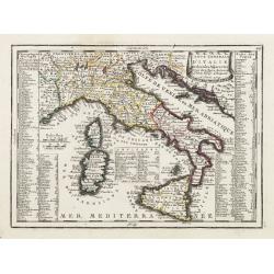
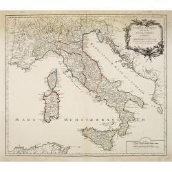
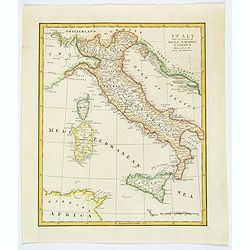
L'Italie.
Rigobert Bonne (1727-1795), French cartographer. His maps are found in a.o. Atlas Moderne (1762), Raynal's Histoire Philos. du Commerce des Indes (1774) and Atlas Encyclo...
Date: Amsterdam, c. 1760
Selling price: ????
Please login to see price!
Sold in 2018
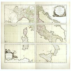
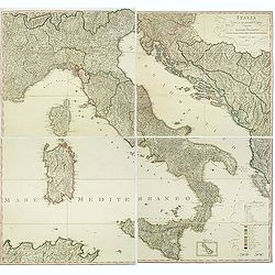
![[Lot of 6 maps of Italy]](/uploads/cache/20941-(1)-250x250.jpg)
[Lot of 6 maps of Italy]
Claude Buy de Mornas (dl 1783), géographe du roi (1764). Atlas Méthodique et Elémentaire de Géographie et d' Histoire, 1761, Atlas Historique et Géographique, 1762.�...
Date: c. 1760
Selling price: ????
Please login to see price!
Sold in 2022
L´Italie divisée en ses differents Etats, Royaumes et Republiques..
Attractive map of Italy and including Corsica, Sardinia, Sicily, much of Provence and portions of the Balkans.Very decorative title cartouche, uncolored as issued. A seco...
Date: Paris 1762
Selling price: ????
Please login to see price!
Sold
Italy.
Uncommon miniature map of Italy, engraved by J.Ellis for "A New General and Universal Atlas Containing Forty five Maps by Andrew Dury".This miniature atlas publ...
Date: London, 1761-1763
Selling price: ????
Please login to see price!
Sold in 2022
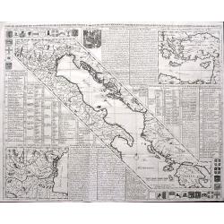
IV FEUILLE
A fantastic large sea-chart from Roux's famous CARTE DE LA MEDITERRANEE EN DOUZE FEUILLES. This is sheet number four of twelve, showing the south of Italy, the island of ...
Date: Marseille, 1764
Selling price: ????
Please login to see price!
Sold in 2021
Tabula Italiae Antiquae. . .
Detailed map of Ancient Italy, including Corsica, Sardinia and Sicily.
Date: Rome, 1764
Selling price: ????
Please login to see price!
Sold in 2023
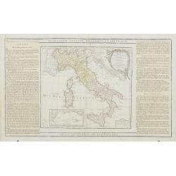
Carte d'Italie, assujettie aux observations astronomiques et aux itinéraires. Comprenant toutes les grandes routes qui traversent les différens Etat de cette région . . .
Six double page original hand-colored engraved post road maps maps of Italy, from the 'Nouvel itinéraire général' by Louis Desnos, marking the major roads. In upper ri...
Date: Paris, 1766
Selling price: ????
Please login to see price!
Sold in 2023
Nieuwe Kaart van Italie na de Nieuwste waarnemingen van de l'Isle en andere
Handsome and detailed map showing Italy as well as Corsica, Sardinia, Minorca, Croatia, Albania, Dalmatia, a bit of Provence, Malta and the northern coast of Africa. The ...
Date: Amsterdam 1769
Selling price: ????
Please login to see price!
Sold in 2014
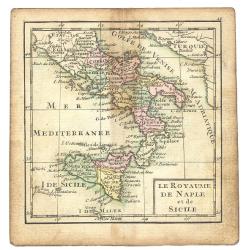
Le Royaume De Naple et de Sicile
A map from the uncommon miniature atlas Almanach Geographique ou Petit Atlas Elémentaire, published by Desnos in Paris ca. 1770. Acclaimed French map publisher and globe...
Date: Paris ca. 1770
Selling price: ????
Please login to see price!
Sold
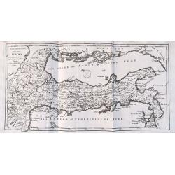
Neue Vorstellung von gantz Italien.
Unusual map of Italy during Roman times - from South Tyrol to Calabria, including a small part of Sicily. With numerous ancient place names. Published in "Neue Samml...
Date: Frankfurt, 1770
Selling price: ????
Please login to see price!
Sold in 2016
Italia Antiqua.
Christoforus Cellearius (1638-1707), geographer. ' Geographia Antiqua', 1686-1812
Date: Leipzig, 1773
Selling price: ????
Please login to see price!
Sold
Nova totius Italiae cum adjecentibus majoribus et minorib Insulis. . .
Miniature map of Italy, a reduction of the appropriate part of Seutter''s folio map of the Americas, drawn by Albert Seutter. An unusual looking map, its projection givin...
Date: Augsburg, J.M.Will, 1778
Selling price: ????
Please login to see price!
Sold in 2022
L'Italia Meridionale presa da quella del Sig. Zannomi.
Rare map of Southern part of Italy with inset of Sicily, from "Atlante Novissimo ad uso Dei Giovani Studiosi Contenuto In Carte XXVII.", published by Giovanni Z...
Date: Rome, 1780
Selling price: ????
Please login to see price!
Sold in 2018
Carte Génerale de l'Italie.
Beautiful copper engraved map of Italy, including Malta, Corsica, and Sardinia. Probably published "Atlas nouveau" by Mentelle. An excellent example of this...
Date: Paris, c. 1782
Selling price: ????
Please login to see price!
Sold in 2013
L'Italie Divisée en ses différents Etats Royaume et Républiques..
Rare map of Italy, prepared by J.B.Nolin and published by Monhare for his Atlas Général a l'usage des colleges et maisons d'education.. Louis Joseph Mondhare published ...
Date: Paris, 1783
Selling price: ????
Please login to see price!
Sold
L'Italie.
Un uncommon re-issue by Desnos of this fine map of Italy, including Sardinia and Corsica. Prepared by Sanson and originally published by Jaillot.The map is colored in out...
Date: Paris 1783
Selling price: ????
Please login to see price!
Sold
L' Italie divisée en ses differents Etats Royaumes et republiques..
Attractive map of the Italian Peninsula, showing also Corsica and Malta. Boundaries outlined in hand color.Ornated with a decorative title cartouche presenting the symbol...
Date: Paris ca 1783
Selling price: ????
Please login to see price!
Sold
L'Italie divisée en ses différents Etats Royaumes et Republiques. . .
Scarce map of Italy prepared by Nolin and published by L.J. Mondhare for his Atlas Général a l'usage des colleges et maisons d'education.. Louis Joseph Mondhare was act...
Date: Paris, 1783
Selling price: ????
Please login to see price!
Sold in 2023
![[Two maps] L'Italie divisée en ses différents etats, royaumes et républiques . . .](/uploads/cache/42816-250x250.jpg)
[Two maps] L'Italie divisée en ses différents etats, royaumes et républiques . . .
Attractive map of Italy, ornated with a decorative title cartouche. Boundaries outlined in hand color.Prepared by Le Sieur Janvier, Jean Denis [Robert], French geographer...
Date: Paris, ca 1783
Selling price: ????
Please login to see price!
Sold in 2018
L'Italie distinguée suivant l'estendue de tous les Estats, Royaumes, républiques, Duchés, Principautés, &c.
Decorative map of Italy including Corsica, Sardinia and Sicily engraved by Cordier and published by Desnos. A text at lower right refers to the earthquake of Messine in 1...
Date: Paris, Desnos, 1783
Selling price: ????
Please login to see price!
Sold in 2026
L'Italie publiee sous les auspices de Monseigneur le Duc d'Orleans..
Finely and crisply engraved map of Italy printed on 4 sheets joined, with large decorative title cartouche.Venetian edition of d'Anville's map, from "Atlas Universel...
Date: Venice, 1776 - 1784
Selling price: ????
Please login to see price!
Sold
![Karte von Italien Verfasst von Herrn D' Anville.. [2 sheets]](/uploads/cache/22196-250x250.jpg)
Karte von Italien Verfasst von Herrn D' Anville.. [2 sheets]
Large two-sheet map of Italy, covering the entire peninsula, from the Alps as far as Apulia. It shows also Sicily, Sardinia, Corsica, Malta, Part of the Tunisian coast, I...
Date: Vienna 1788
Selling price: ????
Please login to see price!
Sold
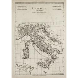
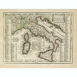
Italia Vetus
Rigobert Bonne (1727-1795), French cartographer. His maps are found in a.o. Atlas Moderne (1762), Raynal's Histoire Philos. du Commerce des Indes (1774) and Atlas Encyclo...
Date: Paris, 1787-1788
Selling price: ????
Please login to see price!
Sold
L' Italie Divisée en tous ses Etats..
Decorative map of Italy, showing Corsica and Sardinia. With ornamental title cartouche and inset map of the Mediterranean including Tunis, Malta and Pantelleria.Flanked b...
Date: Paris, 1790
Selling price: ????
Please login to see price!
Sold
Italy.
Uncommon miniature map from Gibson's "Atlas Minimus, or a New Set of Pocket Maps of the several Empires, Kingdoms and States of the known World".
Date: London, 1792
Selling price: ????
Please login to see price!
Sold in 2011
Naples and Sicily.
Uncommon miniature map from Gibson's "Atlas Minimus, or a New Set of Pocket Maps of the several Empires, Kingdoms and States of the known World".
Date: London, 1792
Selling price: ????
Please login to see price!
Sold in 2011
Carte Generale de L'Italie Redigee Sur les Observations les Plus Authentiqueues.
A decorative and large format map of Italy from the age of Napoleon. Produced by Delamarche in 1798. Charles Delamarche (1740-1817) entered the mapmaking industry as succ...
Date: Paris, 1798
Selling price: ????
Please login to see price!
Sold in 2018
Italy with the Addition of the Southern Parts of Germany as far as.. the Illyric Islands..
Comprehensive map of Italy printed on 4 sheets, joined 2 by 2. Good detail is given with settlements, common and post roads, etc. Relief shown pictorially.
Date: London, 1800
Selling price: ????
Please login to see price!
Sold in 2008
Italy with the Islands of Sicily, Sardinia & Corsica Drawn from the Best Authorities.
Antique copperplate map of Italy, and surrounding countries, together with the islands of Sicily, Sardinia & Corsica. Regions named. With a plain title and a mileage ...
Date: London, ca 1800
Selling price: ????
Please login to see price!
Sold in 2019
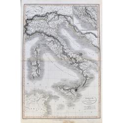
L' Italie.
Map of Italy. By C. F. Delamarche, successor of Robert de Vaugondy, Geographer.
Date: Paris, 1794 - 1806
Selling price: ????
Please login to see price!
Sold in 2018
Italia Divisa ne' suoi Presenti Confini, disegnata da Ignazio Heymann Ufficiale nel Imp: & Ces: Reg: Supremo Uffizio delle Poste in Trieste. E divulgata a sue spese 1806.
Folding wall map showing Italy with Corsica, Sardinia and Sicily, Istria and the Dalmatian coast. Drawn, engraved and published by I. Heymann, Austrian geographer and dir...
Date: Trieste, Ignazo Heymann, 1806
Selling price: ????
Please login to see price!
Sold in 2016
Carte d'Italie.
Map of Italy, including Sicily, Sardinia and Corsica. From Atlas de la Géographie de toutes les parties du monde.. Ouvrage destiné pour l'education, et nécessaire aux ...
Date: Paris, Prudhomme, Levrault, Debray, 1806
Selling price: ????
Please login to see price!
Sold in 2014
Italia, cum insulis et regionibus finitimis.
A large and unusual map of Italy from Smith's 'Classical Atlas'. It shows all of Italy with Corsica, Sardinia, Sicily, and Malta. Filled with historic place names. An ins...
Date: London, 1809
Selling price: ????
Please login to see price!
Sold in 2021
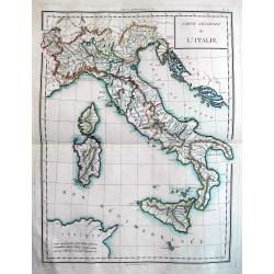
Carte générale de l'Italie rédigée sur les observations les plus authentiques. . .
Map showing Italy and the islands of Corsica, Sardinia and Sicily.
Date: Paris, 1812
Selling price: ????
Please login to see price!
Sold in 2010
Italien.
Nice small map of Italy by Johannes Walch in his rare Allgemeiner Atlas Nach den bewährsten Hülfsmitteln und astronomischen Ortsbestimungen…, edition of 1812.Johann W...
Date: Augsburg, 1812
Selling price: ????
Please login to see price!
Sold in 2023
L'Italie dressée sur les observations de l'académie des sciences. . .
Very interesting map of Italy, including Sardinia, Corsica and Sicily. Buache drew heavenly on the work of Delisle. This edition updated for 1817.Philippe Buache de la Ne...
Date: Paris, 1817
Selling price: ????
Please login to see price!
Sold
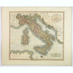
A New Map of Italy. . .
An attractive and beautifully engraved map of Italy by English cartographer John Cary, published in London in 1819. The map shows the country divided into its many duchie...
Date: London, 1819
Selling price: ????
Please login to see price!
Sold in 2020
