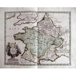
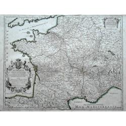
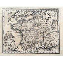
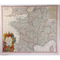
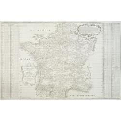
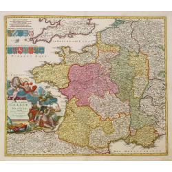
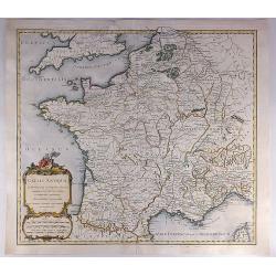
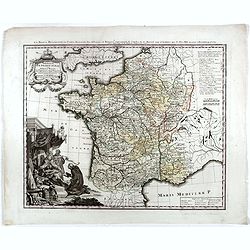
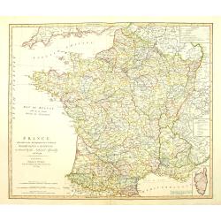
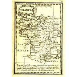
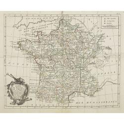
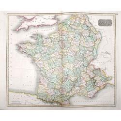
GALLIA VETUS EX IULII CAESARIS...
Interesting map of ancient France. Includes Switzerland and Benelux. With a decorative title cartouche and contemporary hand coloring.
Date: Nuremberg, c1720
Selling price: ????
Please login to see price!
Sold in 2013
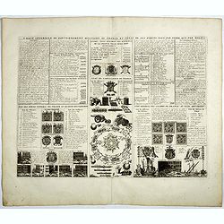
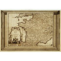
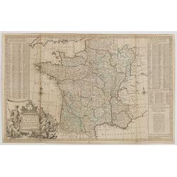
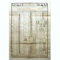
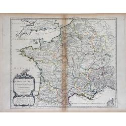
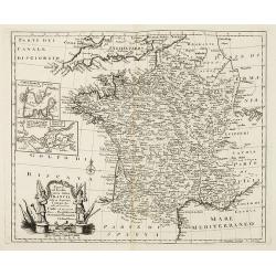
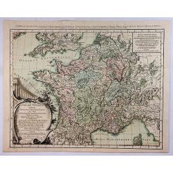
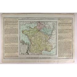
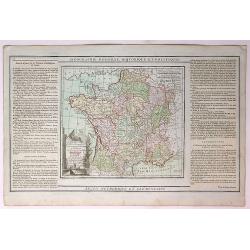
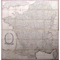
Carte generale du gouvernement militaire de France . . .
Engraved text sheet with numerous illustrations giving military statements of naval and terrestrial forces in France, particularly the state of the artillery and the nava...
Date: Amsterdam, 1720
Selling price: ????
Please login to see price!
Sold in 2019
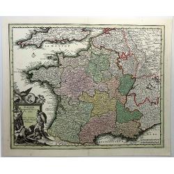
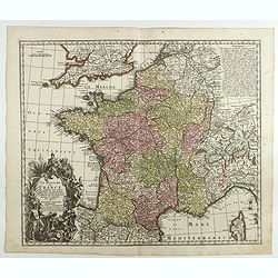
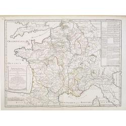
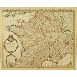
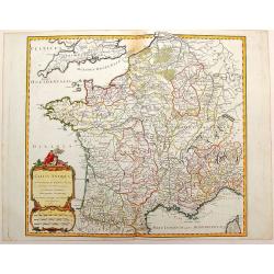
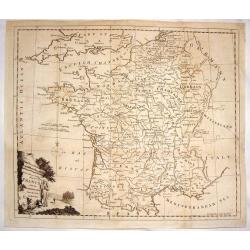
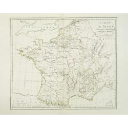
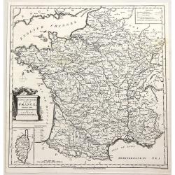
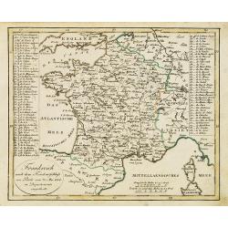
Totius Regni Galliae Sive Franciae Tabula...
An attractive map of France, showing fortified cities, towns, roads, rivers, mountains, etc. Stupendous decorative cartouche (one of the finest that I have seen) with old...
Date: Neurenberg, 1720
Selling price: ????
Please login to see price!
Sold in 2018
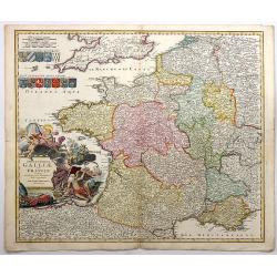
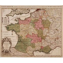
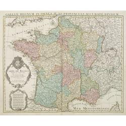
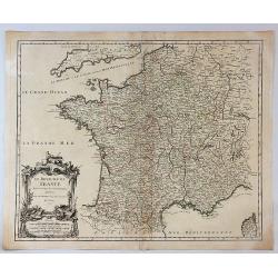
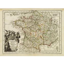
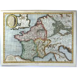
Gallia Cum Provinciis Infertis et Adsitis. . .
A copper engraved detailed map of Ancient France, divided into its provinces by Christopher Weigel in Nurnberg in 1719. Features a decorative cartouche with lions, soldie...
Date: Nurnberg, 1720
Selling price: ????
Please login to see price!
Sold in 2019

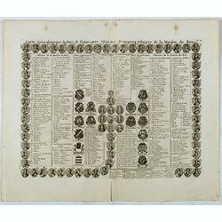
Carte genealogique de la Maison de Bourbon . . .
Genealogical chart of the Bourbons, from Chatelain's monumental 7 volume "Atlas Historique". Henri Abraham Chatelain (1684 – 1743) was a Huguenot pastor of Pa...
Date: Amsterdam, 1720
Selling price: ????
Please login to see price!
Sold in 2018
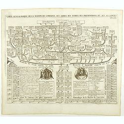
Carte genealogique de la Maison de Savoye . . .
Fine example of Chatelain's attractive plate showing the genealogy of the Savoy House in France.Zacharie Chatelain (d.1723) was the father of Henri Abraham (1684-1743) an...
Date: Amsterdam, ca. 1720
Selling price: ????
Please login to see price!
Sold in 2018
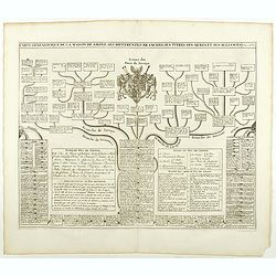
Carte genealogique de la Maison de Lorraine . . .
Fine example of Chatelain's attractive plate showing the genealogy of the Lorraine House in France.Zacharie Chatelain (d.1723) was the father of Henri Abraham (1684-1743)...
Date: Amsterdam, ca. 1720
Selling price: ????
Please login to see price!
Sold in 2018
Carte genealogique des des rois de France depuis Hugue Capet jusqu'à la famillede Valois . . .
Genealogical chart of kings of France, from Chatelain's monumental 7 volume "Atlas Historique". Henri Abraham Chatelain (1684 – 1743) was a Huguenot pastor of...
Date: Amsterdam, 1720
Selling price: ????
Please login to see price!
Sold in 2018
Carte genealogique de la maison de Courtenay avec les differentes branches quelle a formees accompagnee du Blazon des armes de la plus part des alliances des seigneurs de cette famille.
Genealogical chart, from Chatelain's monumental 7 volume "Atlas Historique". Henri Abraham Chatelain (1684 – 1743) was a Huguenot pastor of Parisian origins. ...
Date: Amsterdam, 1720
Selling price: ????
Please login to see price!
Sold in 2020
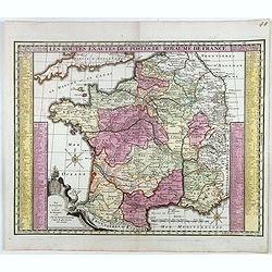
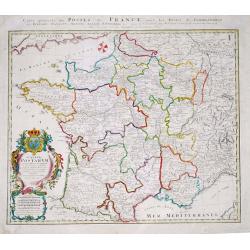
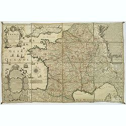
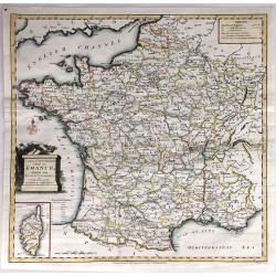
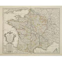
La France divisée par provinces ou sont exactement remarquées toutes les routes des postes du royaume suivant qu'elles sont actuellement établies.
A large and unusual map of France showing the postal routes and post stations includes Switzerland, Luxembourg, parts of Spain, Italy, and Germany.Decorated with a large ...
Date: Paris, 1721
Selling price: ????
Please login to see price!
Sold in 2016
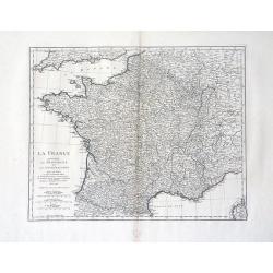
La France, suivant les nouvelles observations..
Uncommon edition of this map of France. With decorative title cartouche lower left corner.This example is unusual in having the additional separately engraved decorative ...
Date: Amsterdam 1728
Selling price: ????
Please login to see price!
Sold
Carte genealogique des Rois de France avec l'Etat des Principaux Officiers de la Maison du roy.
A genealogical tree of the French kings with descriptive French text, from Chatelain's monumental 7 volume "Atlas Historique". Henri Abraham Chatelain (1684 –...
Date: Amsterdam, 1728
Selling price: ????
Please login to see price!
Sold in 2016
Carte genealogique pour conduire à faire connoître sur quoi sont fondés les pre tendants à la succession de la principauté de Neufchatel.
Genealogical tree with two maps "Principauté de Neuchatel" and "Baronie de Arley de la Maison de Chalons", with descriptive French text, from Chatela...
Date: Amsterdam, 1728
Selling price: ????
Please login to see price!
Sold in 2020
Regnum Galliae Moderna
Charming copper engraved map of France from a rare atlas by Zurner and Weigel. With many place names. Decorated with a title cartouche surrounded by figures.
Date: Nuremberg, 1729
Selling price: ????
Please login to see price!
Sold in 2015

Carte du Royaume de France.
A striking map of France, from the “METHODE POUR ETUDIER L’HISTOIRE” by L’Abbe Lenglet du Fresnoy, published in Paris in 1729. The map is quite rare and is not no...
Date: Paris, 1729
Selling price: ????
Please login to see price!
Sold in 2019
" LE ROYAUME DE France Divisé en Toutes ses Provinces et ses acquisitions."
An Amsterdam version of the general map of France by Hubert Jaillot. The scale cartouche upper left has the name of the publisher : P.Mortier et Compagnie.
Date: Amsterdam, ca. 1730
Selling price: ????
Please login to see price!
Sold in 2009
A NEW AND EXACT MAP OF FRANCE...
Decorative two-sheet map of France. Very detailed with towns, rivers, etc. Postal roads are marked with distances between points indicated in leagues. Battle sites in whi...
Date: London, c1730
Selling price: ????
Please login to see price!
Sold in 2014
Le Royaume de France . . .
A finely engraved and decorative mid-18th century map published in Augsburg, Germany. This map shows France.Matthaus Seutter the elder first published his "Atlas Geo...
Date: Augsburg, c. 1730
Selling price: ????
Please login to see price!
Sold in 2018
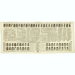
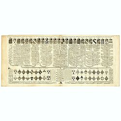
Cavalerie legere françoise et etrangere régimentée sous Louis XIII en 1635. Neuviémz feuille.
Table showing the structure of The regiment of the Kings Cavalry which was a regiment of the cavalry of the Kingdom of France created in 1635 (then regiment of dragons). ...
Date: Paris, ca. 1731
Selling price: ????
Please login to see price!
Sold in 2019
Le Royaume de France
A beautiful map of France, engraved with place names, mountains, rivers, lakes and more. It extends to include Corsica, portions of Spain, Italy, Helvetica and England. T...
Date: Augsburg, 1734
Selling price: ????
Please login to see price!
Sold in 2016
Franciae status sub regibus primae stirpis,. . ./ Etat de la France sous les rois de la première race. . .
A historical map of France depicting the region at the beginning of the Middle Ages. It depicts the kingdom of Clovis, the Founder of France, as it was divided among his ...
Date: Paris, 1740
Selling price: ????
Please login to see price!
Sold
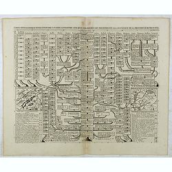
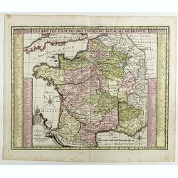
Les routes exactes des Postes du Royaume de France.
post road maps map of France. Seutter the elder (1678-1757) was apprenticed to Johann Baptist Homann in the last years of the seventeenth century in Nuremberg, however, a...
Date: Augsburg, 1740
Selling price: ????
Please login to see price!
Sold in 2016
Les routes exactes des Postes du Royaume de France.
post road maps map of France. Seutter the elder (1678-1757) was apprenticed to Johann Baptist Homann in the last years of the seventeenth century in Nuremberg, however, a...
Date: Augsburg, 1740
Selling price: ????
Please login to see price!
Sold in 2017
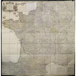
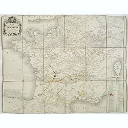
La France Dressée sur un grand nombre de Cartes particulières manuscrites ou imprimées levées sur les lieux et conférées avec les Itinéraires
Decorative map of France prepared by G. de l'Isle and re-issued by Covens and Mortier.
Date: Amsterdam, ca. 1740
Selling price: ????
Please login to see price!
Sold in 2020
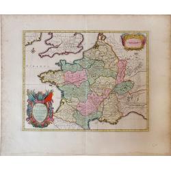
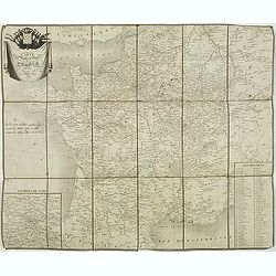
Gallia vetus ex C.Iulii Caesaris Comentariis Descripta.
Sanson map of France republished by the Covens and Mortier firm, with fine color. Depicts France described by Julius Caesar marking the locations of tribes and ancient to...
Date: Amsterdam, 1741
Selling price: ????
Please login to see price!
Sold in 2010
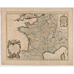
Regni Galliae seu Franciae et Navarrae.
A secondary title in French above the map : "Carte de France dressée par Guillaume de L'Isle et accomodée par les Heritiers d'Homann. With a large decorative title...
Date: Nuremberg, 1741
Selling price: ????
Please login to see price!
Sold in 2021
Nouvelle carte qui comprend les principaux Triangles qui servent de Fondement à la Description géométrique de la France. . .
Detailed map of France, showing city of Paris, Calais, Perigueux, Nantes, Marseille, Avignon, Reims…To the left and to the right 2 cartouches with the list of principal...
Date: Paris, ca. 1744
Selling price: ????
Please login to see price!
Sold
Carte De France Dressée pour l'usage du Roy..
Beautifully engraved, detailed general map of France, illustrating towns, roads, rivers, forests, etc. Embellished by 2 decorative cartouches: a title cartouche surmounte...
Date: Amsterdam c. 1745
Selling price: ????
Please login to see price!
Sold
Carte De France Dressée pour l'usage du Roy. . .
Beautifully engraved, detailed general map of France, illustrating towns, roads, rivers, forests, etc. Embellished by two decorative cartouches: a title cartouche surmoun...
Date: Amsterdam, c. 1745
Selling price: ????
Please login to see price!
Sold
Gallia Postarum geografice designata.
Homann Heirs (of Johann Baptist and Johann Christof) published: Grosser Atlas, 1731, 1737. Geogr. Maior, 1759, Atlas Homannianus, 1762.Alexis Jaillot's map showing the po...
Date: Nurnberg, 1745
Selling price: ????
Please login to see price!
Sold in 2019
Totius Galliae sive Franciae tabula..
Johann Baptist Homann's well-engraved map of France has a large decorative cartouche and 12 coats of arms of different provinces. Detailed map centred on Venice. Johann B...
Date: Nuremberg, 1747
Selling price: ????
Please login to see price!
Sold
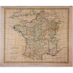
Gallia Antiqua in Provincias et Populos divisa. . .
Large map of Ancient France, divided into provinces, published in de Vaugondy's Atlas Universal. Includes towns, mountains, rivers, lakes and other details. Decorative ti...
Date: Paris, 1750
Selling price: ????
Please login to see price!
Sold in 2010
Gallia Antiqua in Provincias et Populos Divisa
This large map of the Roman time Gauls (Gallia) dated 1750, was incorporated in the 1st edition of "Atlas Universel" in 1757. With significant portions of Belgi...
Date: Paris, 1750
Selling price: ????
Please login to see price!
Sold in 2015
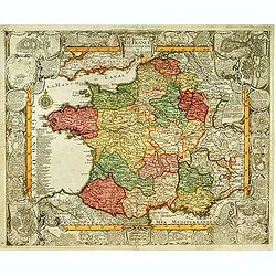
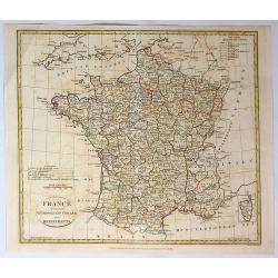
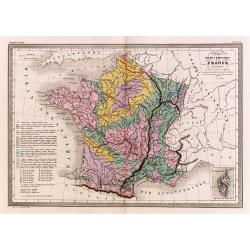
Le Royaume de France Divise Suivant les Gouvernemens Generaux.
A fine politically and topographically detailed 1750 map of France by Robert de Vaugondy. It covers all of France from the English Channel to Corsica and Spain.The map fe...
Date: Paris, 1750
Selling price: ????
Please login to see price!
Sold in 2017
Gallia Antiqua in Provincias et Populos Divisa.
An attractive map of France or 'Gaul'. It features Gallia during ancient Roman times, and extends from the English Channel south as far as the Pyrenees Mountains and Hisp...
Date: Paris, 1750
Selling price: ????
Please login to see price!
Sold in 2023
Nuova ed Esatta carta della Francia. . .
General map of France, after Emanuel Bowen, but from an Italian text edition. With an elegant baroque title cartouche. With inset charts of the harbors of Toulon & Br...
Date: London, 1752
Selling price: ????
Please login to see price!
Sold
A New and Accurate Map of France with the Netherlands From the Best Authorities.
An interesting map featuring a rural cartouche with a woman holding a cross and looking at a papal crown and chalais laying on the ground. Emanuel Bowen (1714-1767), ma...
Date: London, 1752
Selling price: ????
Please login to see price!
Sold in 2015
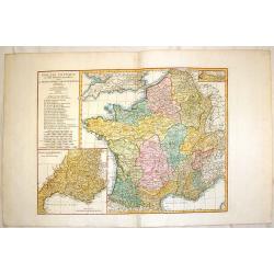
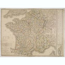
La France Divisée En ses 37 Gouvernements Militaires.
Fine map of France with decorative title cartouche. George Louis Le Rouge was active from 1740- till 1780 as a publisher, and was appointed engineer for the King of Franc...
Date: Paris 1756
Selling price: ????
Please login to see price!
Sold
La France par Postes.
Fine map of France. George Louis Le Rouge was active from 1740- till 1780 as a publisher, and was appointed engineer for the King of France. From his Atlas Nouveau Portat...
Date: Paris 1756
Selling price: ????
Please login to see price!
Sold
Le Royaume de France et les conquetes de Louis le Grand.
Engraved by J.Christofle Steinberger. RARE and very decorative map of France surrounded with 20 insets of town plans : [1.] Philisbourg: [2.] Mons: [3.] Longwy: [4.] Homb...
Date: Augsburg 1760
Selling price: ????
Please login to see price!
Sold
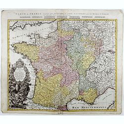
La France. Dressée suivant les nouvelles observation de Mrs De l'Academie Royale des Sciences Par Charles Inselin geografe et graveur.
A large and detailed map of France, decorated with a large title cartouche, and two others around engraved text descriptions of France and its provinces. Originally issue...
Date: Paris, 1760
Selling price: ????
Please login to see price!
Sold in 2011
Gallia Antiqua ex Aevi Romani Monumentis Eruta.
A fine copper engraved map of France and Belgium in ancient times. The title section includes a list of regions by Roman numeral to make them easier to find. The detailed...
Date: Paris, 1760
Selling price: ????
Please login to see price!
Sold in 2015
La France bénédictine, ou carte générale des abbayes . . .
This uncommon map is showing France with its provinces according to the Order of Saint Benedict. Larghe title cartouche, lower left, showing the King of France, who is si...
Date: Nuremberg, 1760
Selling price: ????
Please login to see price!
Sold in 2019
Galliae Veteris Tabula Populus. . .
This attractive copper-engraved map shows France with the ancient Roman names in Gaul. The detailed map depicts mountains, rivers, roads, and numerous towns. A beautiful ...
Date: Venice, 1764
Selling price: ????
Please login to see price!
Sold in 2020
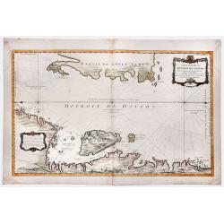
Carte Reduite du DETROIT DE DAVIDS. Faite an Depost des Cartes Plans et Journaux de la Marine, . . . MDCCLXV.
A beautiful, large chart of the French sea of the Davis Strait, published by Jacques Nicolas Bellin in Paris. The note at the bottom left indicates that the map was const...
Date: Paris, 1765
Selling price: ????
Please login to see price!
Sold in 2019
Carte Générale des Côtes de de France.
Index map of the French coasts with superb decorative cartouche depicting the sea landing of a boat.
Date: Paris, 1766
Selling price: ????
Please login to see price!
Sold in 2011
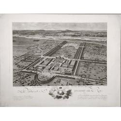
Plan perspective de l'École royale militaire.
A decorative bird's eye view of the complex of the French military school in Paris.
Date: Paris, 1778
Selling price: ????
Please login to see price!
Sold in 2022
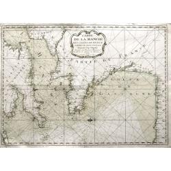
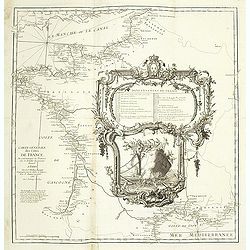
Carte de la Manche des costes de France parties de celle d'Espagne jusqu'au Cap Orgetal.
A very rare sea-chart of the Channel between England and France, including the Bay of Biscay with the coasts of northern Spain, and even a small tip of Ireland. A very ap...
Date: Bordeaux, 1779
Selling price: ????
Please login to see price!
Sold in 2021
La France Divisee en Provinces et en Generalites Dont le plan est selui de l'ancienne Gaule. . .
A beautiful, large scale, highly detailed, 18th century map of France modeled on a plan of ancient Gaul by Jean Baptiste Bourguignon D'Anville, with major boundaries colo...
Date: Paris, 1780
Selling price: ????
Please login to see price!
Sold in 2010
La France Divisée en IX Régions, 10 Métropoles, et 85 Départements ..
Rare map of France prepared after J.B.Nolin and published by Monhare for his Atlas Général a l'usage des colleges et maisons d'education.. Lower right inset map of Cors...
Date: Paris 1783
Selling price: ????
Please login to see price!
Sold
Carte Itineraire et Generaledes 18 Feuilles de l'Indicateur de France.
This is a striking 1786 Desnos and Brion map of France showing roads and the 18 administrative divisions. To the left and right of the map are paste downs of French text ...
Date: Paris, 1786
Selling price: ????
Please login to see price!
Sold in 2020
Carte de France historique et chronologique du regne de Henri IV. . .
Map of France during the regime of Henri IV. With a color key in lower left. Prepared by J.A. Dezauche, who was a publisher, map dealer and continued the publications of ...
Date: Paris, 1787
Selling price: ????
Please login to see price!
Sold
Les Gaulles Sous Les Trois Monarches
A detailed and attractive map of France at the time of Clovis in the 5th century. Featuring an interesting cartouche that partially covers Great Britain. By Philippe de P...
Date: Paris, 1787
Selling price: ????
Please login to see price!
Sold in 2016
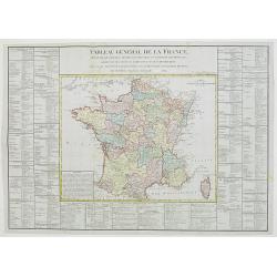
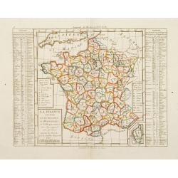
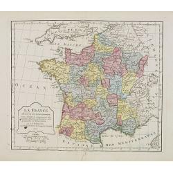
Tableau général de la France,..
Uncommon map of France, with inset map of Corsica. Surrounded by geographical information for each department along with useful statistical information.Prepared by Louis ...
Date: Paris, 1789
Selling price: ????
Please login to see price!
Sold in 2012
France divided into Metropolitan circles departments & districts.
Map of France with an inset of Corsica in the same scale. William Faden (1750?-1836) was Geographer to His Majesty and to H.R.H. the Prince of Wales.
Date: London, 1790
Selling price: ????
Please login to see price!
Sold in 2010
La France, Divisee en ses Quarante Gouvernemens Generaux et Militaires...
An attractive and informative map of France by French cartographer, Louis Brion de la Tour. It notes numerous towns, cities, rivers, forests, mountains and other topograp...
Date: Paris, 1790
Selling price: ????
Please login to see price!
Sold in 2019
Galliae Descriptio ex Iulij Caesaris Commentarijs.
An antique map of ancient France or Gaul (Gallia). It is from about 1790 by an unknown mapmaker. There is an interesting cartouche featuring weapons and flags.
Date: Paris, 1790
Selling price: ????
Please login to see price!
Sold in 2021
Das Heutige Frankreich.
Franz Johann Joseph von Reilly. He was active as an art dealer, publisher and mapmaker in Vienna. Issued in "Schauplatz der Welt".
Date: Veinna 1791
Selling price: ????
Please login to see price!
Sold
France.
Uncommon miniature map from Gibson's "Atlas Minimus, or a New Set of Pocket Maps of the several Empires, Kingdoms and States of the known World".
Date: London, 1792
Selling price: ????
Please login to see price!
Sold
A New and Accurate Map of France, divided into Departments, Districts....
A fine map of France from Spencer's 'History of England'. The title cartouche features the French flag and a military helmet.There is an insert of the Island of Corsica.
Date: London, 1794
Selling price: ????
Please login to see price!
Sold in 2016
A New & Accurate Map of France, Divided Into Departments, districts & c. as Decreed by the National Assembly.
A highly detailed map of France, published by John Cary, the founder of the famous English cartographic firm. Detail is copious and precisely delineated, including mounta...
Date: London, 1794
Selling price: ????
Please login to see price!
Sold in 2019
Carte de France divisée en LXXXIII departements Reduitte en neuf Feuilles égalles aux 24 Petittes de Illustre CASSINI. . .
Rare wall map of France published by Johann Michael Probst the younger (1757-1809). Prepared by Cassini.In 1747 Louis XV asked Caesar-Francois Cassini (Cassini III) to cr...
Date: Augsburg, 1795
Selling price: ????
Please login to see price!
Sold
France Divided Into Provinces.
A fine map of France with outline color delineating the provinces. Published in London in 1798 by G.G. & J Robinson, and engraved by S. Neele.
Date: London, 1798
Selling price: ????
Please login to see price!
Sold in 2017
France Divided Into Metropolitan Circles and Departments.
A fine map of France divided into Metropolitan Circles and Departments by the English map publisher Clement Cruttwell. The French Department system was established in 179...
Date: London, 1799
Selling price: ????
Please login to see price!
Sold in 2018
Carte de la France divisée en 108 departemens. . .
General map of France, showing a road-system and 108 departments. In lower right inset map of Corsica (140x70mm.) The map is dated 1804 and "An 12" being the 12...
Date: Paris, An 12 / 1804
Selling price: ????
Please login to see price!
Sold
La France. . . .
Map of France. By C. F. Delamarche, successor of Robert de Vaugondy, Geographer.
Date: Paris, 1806
Selling price: ????
Please login to see price!
Sold in 2008
Carte du Royaume de France . . .
General map of France, from Atlas moderne portatif composé de vingt-huit cartes sur toutes les parties du globe terrestre .. A l'usage des Colléges, des Pensions & ...
Date: Paris, Prudhomme, Levrault, Debray, 1806
Selling price: ????
Please login to see price!
Sold in 2009
A Correct Map of France according to the New Divisions into Metropolitan Circles, Departments and Districts as decreed by the National Assembly, January 15th 1790 from a reduced copy of M. Cassini's large map...
A very large folding map of France with parts of England, the Benelux, Germany, Switzerland, Italy, and Spain. With an inset map of Corsica. Decorated with a large title ...
Date: London, 1806
Selling price: ????
Please login to see price!
Sold in 2017
Frankreich nach dem Friedensschluss. . .
Nice small map of France published by Johannes Walch in his rare Allgemeiner Atlas Nach den bewährsten Hülfsmitteln und astronomischen Ortsbestimungen…, edition of 18...
Date: Augsburg, 1812
Selling price: ????
Please login to see price!
Sold
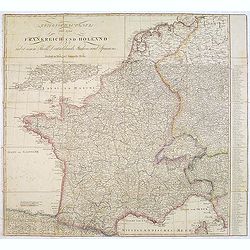
Kriegsschauplatz von ganz Frankreich und Holland.
Rare folding map map of France and the Low Countries published in the year of the defeat of Napoleon. Also including Switzerland and small part of Italy. In Italy the par...
Date: Vienna, 1814
Selling price: ????
Please login to see price!
Sold in 2013
France
A beautiful map of France, engraved and published during Napoleon Bonaparte's time, with stunning color, and magnificent detail. Engraved by Hewitt.
Date: London, ca 1814
Selling price: ????
Please login to see price!
Sold in 2016
Carte de France.
Detailed map of France, with an updated date of "An 9" 1820 in the large allegoric title cartouche with a detailed title and dedication to the famous French car...
Date: Paris, 1820
Selling price: ????
Please login to see price!
Sold
Cartes de France divisée en ses divers départemens,. . .
Map of France showing the different departments, all borders colored in outline.
Date: Paris, 1823
Selling price: ????
Please login to see price!
Sold
![[Title page] Nouvelle géographie et statistique de la France, Alger et la Belgique.](/uploads/cache/41675-250x250.jpg)
[Title page] Nouvelle géographie et statistique de la France, Alger et la Belgique.
Frontispiece with map of France with two sheets showing a mail exchanges between Henry and the rector, the prefect and the ministry of the public institution, plus a desc...
Date: Paris, 1834
Selling price: ????
Please login to see price!
Sold in 2020
Carte physique et minéralogique de la France.
Thematical map of France with inset map of Corsica and Paris.From Malte-Brun's Atlas Géographie Universelle.."., revised by Jean Jacques Nicolas Huot.This...
Date: Paris 1837
Selling price: ????
Please login to see price!
Sold
Carte des routes de poste de France dressée par Tardieu Graveur 1838.
This post road maps map of France is showing incredible detail of the postal roads, stations (or "stages"), and the distances from town to town. Lower left an i...
Date: Paris, 1838
Selling price: ????
Please login to see price!
Sold
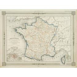
The Kingdom of France describing the New Limits according to the Treaty of Paris.
A large, beautifully detailed, and colorful map of France divided into 86 departments, with Corsica as an inset. No cartouche but very decorative calligraphy in the title...
Date: London, 1838
Selling price: ????
Please login to see price!
Sold in 2016
Carte des routes de poste de France dressée par ordre de Mr Conte, Conseiler d'Etat Directeur de l'administration et Président du conseil des Postes.
This post road maps map of France is showing incredible detail of the postal roads, stations (or "stages"), and the distances from town to town. Lower right, a ...
Date: Paris, 1843
Selling price: ????
Please login to see price!
Sold
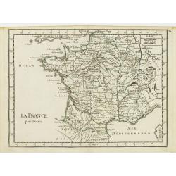
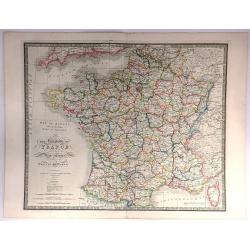
France par Provinces..
Fine map of France with inset plan of Paris at the year 1789, in lower right inset map of Corsica. Prepared by J.G.Barbié du Bocage. Published by Basset, rue de Seine 33...
Date: Paris 1846
Selling price: ????
Please login to see price!
Sold
France
A fine map of France by George Frederick Cruchley. It covers all of France, seen here divided in its various departments. An inset shows the French island of Corsica. Ele...
Date: London, 1850
Selling price: ????
Please login to see price!
Sold in 2016
