Browse Listings in Europe > Eastern Europe
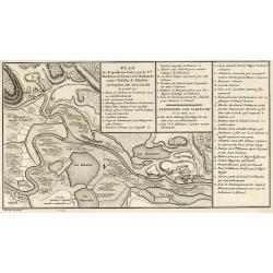
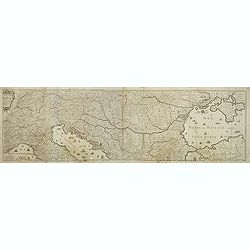
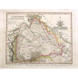
Plan des Expéditions faites par le Gal. Weissman de l\'autre côté du Danube contre Tultschi & Isaktschi. Attaque de Tultschi le 4 Avril 1771
Engraved map of the Danube River between Isaccea, Tulcea in Romania and Izmail in Moldavia. With detail of the expeditions of General Weissman in 1771. From the Atlas Vol...
Place & Date: Paris, 1783
Selling price: $120
Sold in 2010
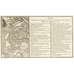
Plan de l\'Attaque du Retranchement, du Camp, et de la Flotte des Turcs par le Gal. Weisman, près de Tultschi, le 30 Juin 1771
Engraved map of the Danube River between Tulcea in Romania and Izmail in Moldavia. With detail of the expeditions of General Weissman in 1771. From the Atlas Volume of &q...
Place & Date: Paris, 1783
Selling price: $120
Sold in 2010
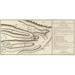
Plan de la Bataille & de la Victoire remportée par les Russes sur les Turcs commandés par le Grand Visir près de la riviere Kagul en Bessarabie. le 21 Julliet, 1770
Engraved map of the Battle of Cahul in today Moldavia during the Russo-Turkish War 1768-1774 on 21 July 1770. From the rare Atlas Volume of "Histoire physique, moral...
Place & Date: Paris, 1783
Selling price: $130
Sold in 2009
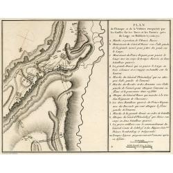
Plan de l'Attaque & de la Victoire remportée par les Russes sur les Turcs et les Tartars près du Large en Moldavie le 7 Julliet, 1770
Engraved map of the Battle of at the Large in today Moldavia during the Russo-Turkish War 1768-1774 on 7 July 1770. From the rare Atlas Volume of "Histoire physique,...
Place & Date: Paris, 1783
Selling price: $110
Sold in 2009
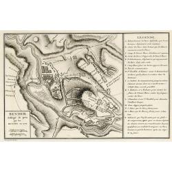
Bender Assiégé & pris par les Russes en 1770
Engraved map of the Battle of Bender in today Moldavia during the Russo-Turkish War 1768-1774 in 1770. From the rare Atlas Volume of "Histoire physique, morale, civi...
Place & Date: Paris, 1783
Selling price: $110
Sold in 2009
Le cours du Danube dédié au roy. . .
A later edition of this beautiful and detailed map of the river Danube, originally published by Du Val in 1703. Here with the date "1783" and the address change...
Place & Date: Paris, 1783
Selling price: $300
Sold in 2011
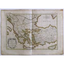
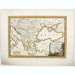
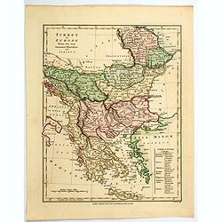
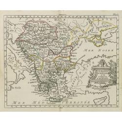
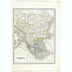
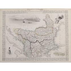
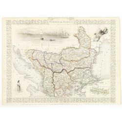
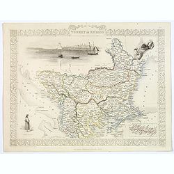
Turquie d' Europe
This finely engraved map is roughly centered on Greece, including the islands of Crete and Cyprus. The map covers the region from Bosnia and Serbia to the Black Sea and C...
Place & Date: Paris, 1783
Selling price: $70
Sold in 2016
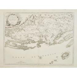
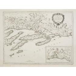
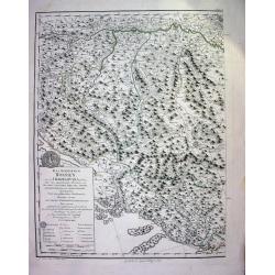
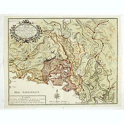
Nouvelle Carte de la Partie Occidentale de Dalmatie, dressee sur les lieux.
Finely and crisply engraved map depicting part of the Dalmatian coastline and its islands between Zadar and Omis, south of Split.In the lower right corner the island Vis,...
Place & Date: Venice, 1776 - 1784
Selling price: $450
Sold in 2010
Nouvelle Carte de la Partie Orientale de Dalmatie, dressée sur les lieux.
Finely and crisply engraved map depicting the southern part of the Dalmatian coastline and its islands.Encompassing the area from the southern half of Brac island to the ...
Place & Date: Venice, 1776 - 1784
Selling price: $250
Sold
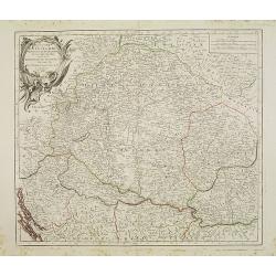
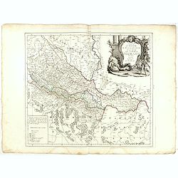
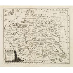
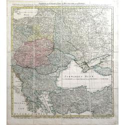
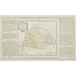
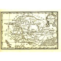
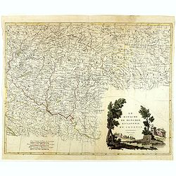
Royaume de Hongrie, Principauté de Transilvanie..
Detailed map encompassing present day Hungary and parts of Romania, Czechoslovakia, Bosnia, etc.Venetian edition of the map by Bellin, to whom Santini gives credit in the...
Place & Date: Venice, 1776 - 1784
Selling price: $200
Sold in 2008
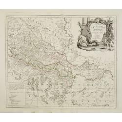
Royaume d'Esclavonie et du Duché De Syrmie..
Detailed map encompassing show us Danube and to the right Belgrade.Venetian edition of the map by Bellin, to whom Santini gives credit in the cartouche.From "Atlas U...
Place & Date: Venice, 1776 - 1784
Selling price: $250
Sold in 2008
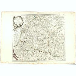
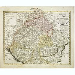
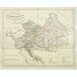
Royaume de Hongrie divisee dans ces cercles. . .
Detailed map encompassing present day Hungary with the river Danube and the towns of Belgrade, Budapest, Vienna, etc.From "Atlas Universel" published by Santini...
Place & Date: Venice, 1776 - 1784
Selling price: $50
Sold in 2015
Royaume d'Esclavonie et du Duché De Syrmie..
Detailed map encompassing show us Danube and to the right Belgrade.From "Atlas Universel" published by Santini in 1776-84. The atlas is effectively an Italian c...
Place & Date: Venice, 1776 - 1784
Selling price: $70
Sold in 2015
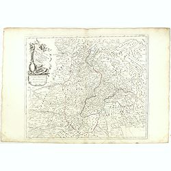
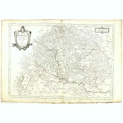
Principauté de Transilvanie et Pays circonvoisins. . .
Detailed map encompassing part of present-day Hungary.With ornamental title cartouche and noteworthy topographical detail.The map was prepared by the Venetian cartographe...
Place & Date: Venice, 1784
Selling price: $30
Sold in 2022
Royaume de Hongrie divisee dans ces cercles. . .
Detailed map encompassing present day Hungary with the river Danube and the towns of Belgrade, Budapest, Vienna, etc.Venetian edition of the map by R. de Vaugondy, to who...
Place & Date: Venice, 1776 - 1784
Selling price: $100
Sold in 2015
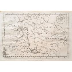
A map of Hungary, Transilvania, Sclavonia, and Croatia.
Unusual map of Eastern Europe, from Vienna and the Gulf of Venise to the border of Moldova and the Carpathian Mountains. Includes the Balaton lake, Bratislava, Belgrade, ...
Place & Date: London, 1784
Selling price: $25
Sold in 2016
![[2 maps] Parte Occidentale del Regno di Boemia Di Nuova Projezione.. / Parte Occidentale del Regno di Boemia Di Nuova Projezione..](/uploads/cache/23642-250x250.jpg)
[2 maps] Parte Occidentale del Regno di Boemia Di Nuova Projezione.. / Parte Occidentale del Regno di Boemia Di Nuova Projezione..
Depicting what is now the Czech Republic as far East as Prague. Embellished with a title vignette lower left corner.Engraved by G. Zuliani after the drawing by G. Pitteri...
Place & Date: Venice 1785
Selling price: $135
Sold
Poland, Lithuania and Prussia Drawn from the latest Authorities by Thos. Kitchin Geogr.
Map showing the region along the Baltic Sea from Stettin to Riga. In the lower right is part of the course of the Dnieper river and part of Ukraine.To the right of the ti...
Place & Date: Paris, 1786
Selling price: $80
Sold in 2008
Das Koenigreich Bosnien, und die Herzegovina (Rama)
Large copper-engraved wallmap showing Bosnia and Herzegovina, large parts of Dalmatia, the Republic of Dubrovnik, parts of Croatia, Slavonia, Serbia, Albania and Macedoni...
Place & Date: Vienna, 1788
Selling price: $190
Sold
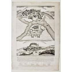
Descrizione della fortezza, e città di Belgrado.
Scarce publication printed just before the Austrian attack to Beograde in 1789. The print is divide in three parts called « Prospetto della fortezza e parte della città...
Place & Date: Venice, 1788
Selling price: $900
Sold in 2019
L'Ungheria e la Turchia Europea. . .
Cassini's beautiful map of Greece and the Balkans, but also including parts of Germany, today's Ukraine and Italy. It shows the eastern Mediterranean, the Gulf of Venice ...
Place & Date: Rome, 1788
Selling price: $80
Sold in 2023
Charte von Ungarn Polen, Russland und der Turkey...
Exceptional folding map of Eastern Europe including the Black Sea published by the Schneider-Weigel firm in Nuremberg, Germany. Includes the countries of Greece, Bulgaria...
Place & Date: Nuremberg, 1789
Selling price: $602
Sold in 2010
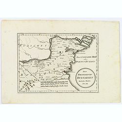
Die Landschaft Romanien, No 16.
Detailed copperplate map featuring parts of Turkey and Southern Bulgaria. Included is Constantinopel. Joseph von Reilly (1766 – 1820) was a Viennese art dealer who tu...
Place & Date: Vienna, 1789
Selling price: $36
Sold in 2016
Carte de la partie d'Albanie occupée par le Bacha de Scutari. . . - Karte des Theils von Albanien so der Bascha von Scutari in besitze hat. . .
Detailed map of Albania. Prepared by François Joseph Maire (Vienna, 1738 - c.1800). F.J. Maire was a publisher, geographer and engineer active in Vienna. He published so...
Place & Date: Vienna, 1788-1789
Selling price: $475
Sold in 2014
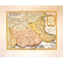
Des Koenigreichs Bulgarien. . .
Von Reilly's map of eastern Bulgaria as it was toward the end of the eighteenth century from the river Danube to the Black Sea. Shows rivers, mountains, larger cities and...
Place & Date: Vienna, 1789
Selling price: $17
Sold in 2021
La Hongrie avec les Provinces adjacentes. . .
Attractive map of Hungary, adorned with a rococo-style title cartouche.Left and right box with geographical information about the area. Printed on 2 paste-on slips.Prepar...
Place & Date: Paris, 1790
Selling price: $50
Sold in 2009
General Charte von Ungarn :mit seinem Nebenländern Croatien, Dalmatien, Slavonien und Siebenbürgen, ingleichen Gallizien und der Bukowina nebst. . .
Map of Hungary prepared by F. L. Güssefeld and published by Homann Heirs. Engraved by I. Rausch.
Place & Date: Nuremberg, 1790
Selling price: $175
Sold in 2012
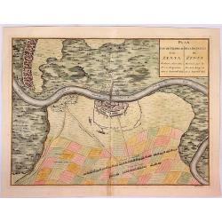
Plan van de Veldtslag van Zenta.
A map of the fortifications and surrounding area of troop orders during the battle of Senta in 1697, between the Imperial and Turkish troops .The birds-eye plan is from J...
Place & Date: Paris, ca. 1790
Selling price: $160
Sold in 2018
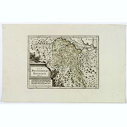
Das Koenigreich Bosnien.
A nice map of Bosnia, mapped with its old borders, prior to the Ottoman rule. Western Bosnia is labelled "Turkish Croatia". The region is seen as very heavily w...
Place & Date: Vienna, 1790
Selling price: $65
Sold in 2018
Hungary.
Uncommon miniature map from Gibson's "Atlas Minimus, or a New Set of Pocket Maps of the several Empires, Kingdoms and States of the known World".
Place & Date: London, 1792
Selling price: $30
Sold in 2011
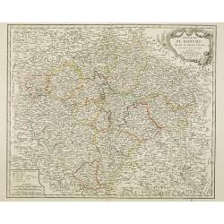
Dei Markfraftschaft Maehren, Nro. 114.
Hand-colored copper engraved map of Moravia. Interesting cartouche with three hunting dogs and a rifle. Joseph von Reilly (1766 – 1820) was a Viennese art dealer who t...
Place & Date: Vienna, 1793
Selling price: $17
Sold in 2016
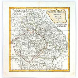
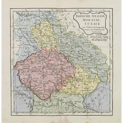
Boheme, Silesie, Moravie, Lucace.
A highly detailed map of Bohemia, Silesia, Moravia and Lusace, by Charles François Delamarche, the successor to Robert de Vaugondy.Charles Francois Delamarche, (1740–1...
Place & Date: Paris, 1794
Selling price: $15
Sold in 2016
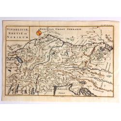
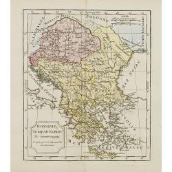
Vindelicie, Rhetie en Norikum.
Striking copper engraved original map of Greece, Bulgaria, Romania, and Macedonia. Christopher Cellarius (C. Keller) (1638-1707) was a geography professor who held positi...
Place & Date: London, 1796
Selling price: $64
Sold in 2017
Moson Varmegye (Comitatus Mosoniensis).
A rare map on a large scale of the area of Moson county centered on Magyaróvár and Moson. It includes a section of today's Austria, with the northern part of Lake Neusi...
Place & Date: Vienna, 1796
Selling price: $100
Sold in 2017
![[I. Dago] [I. Wormso]](/uploads/cache/22199-250x250.jpg)
[I. Dago] [I. Wormso]
Extremely rare sea chart centered on Hiiumaa (Dago) and Vormsi (Wormso) Islands, off the coast of Estonia.
Place & Date: Amsterdam, 1797
Selling price: $300
Sold in 2008
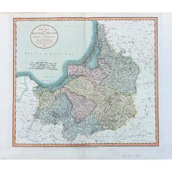
A New Map of the Kingdom of Prussia
Early edition of Cary's fine map of Prussia, the Gulf of Danzig (Gdansk), parts of Poland until Bialystok, today Kaliningrad, and Lithuania with Memel (Klaipėda). One ...
Place & Date: London, 1799
Turkey in Europe.
An attractive map, in beautiful original color, of Turkey in Europe, that part of the Ottoman Empire that lay west of Constantinople. It shows the countries that border t...
Place & Date: London, 1800
Selling price: $17
Sold in 2020
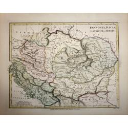
Pannonia, Dacia, Illyricum et Moesia.
A copper engraved map by John Roper, published in "Wilkinson's Atlas Classica" in 1801. The map covers the ancient Roman provinces of Pannonia, Dacia, Illyricum...
Place & Date: London, 1801
Selling price: $50
Sold in 2016
Le Royaume de Hongrie, Esclavonie et Croatie.
Map Of Hungary, Moldavia and southern part of Poland with Galicia . The area of Galicia refers to the region that came to Poland during the first partition in 1772.This i...
Place & Date: Venise, 1802
Selling price: $465
Sold in 2018
Allgemeine Charte zur Uebersicht der Kirchlichen Verfassung des oesterreichischen Staates = Carte eccle´siastique de la monarchie autrichienne : mit Bemerkung aller Erzbisthu¨mer. . .
Detailled map showing Central Europe and showing the Austria-Hungarian Monarchy. The map includes Austria, with parts of Poland, Germany, Italy, prepared by Karl Joseph K...
Place & Date: Vienna, Kunst und Industrie Comptoirs,1804
Selling price: $135
Sold in 2013
Royaume de Boheme divise en douze cercles. . .
Uncommon general map of the Czech Republic, centered on Prague. Prepared after a map of Johann Christoph Müller (1673-1721), who was a Austrian cartographer.Uncommon lat...
Place & Date: Paris, dated 1805
Selling price: $150
Sold in 2014
Hongrie, Turquie Europe..
Map of Hungary, southeast European countries in the Balkan peninsula, and Greece. By C. F. Delamarche, the successor of Robert de Vaugondy, Geographer.
Place & Date: Paris, 1794 - 1806
Selling price: $50
Sold in 2008
Bohême, Silésie, Moravie, Lusace.
Map of central Europe including Bohemia, Austria, Hungary, Silesia and Moravia. By C. F. Delamarche, successor of Robert de Vaugondy, Geographer.
Place & Date: Paris, 1794 - 1806
Selling price: $80
Sold in 2015
Le Royaume de Hongrie et la Turquie d' Europe . . .
Map of the Hungary, the Balkan States and present-day Greece, from Atlas moderne portatif composé de vingt-huit cartes sur toutes les parties du globe terrestre .. A l'u...
Place & Date: Paris, Prudhomme, Levrault, Debray, 1806
Selling price: $100
Sold in 2010
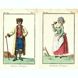
Bohémienne / Bohémien de Prague. (2 prints)
Two originally hand-colored mezzotints of citizens of Prague engraved by Félix Mixelle and Lachaussée Jeune after Jacques Grasset de Saint-Sauveur.As an etcher, drawer ...
Place & Date: Paris,1801-1806
Selling price: $30
Sold in 2016
![[Part of a wall map of Hungary].](/uploads/cache/42560-250x250.jpg)
[Part of a wall map of Hungary].
The Upper left corner of the large folding wall map of Hungary was prepared by Ignac Müller and published first in 1769. The map was made for official use and was kept ...
Place & Date: Vienna, T.Mollo, 1769 - 1807
Selling price: $75
Sold in 2023
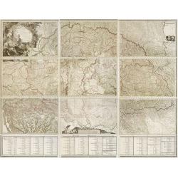
Mappa Generalis regni Hungariae partiumque adnexarum Croatiae, Slavoniae et Confiniorum Militarium Magni item PrincipatusTransylvaniae geometricis partium dimensionibus, recentissimisque astronomicis observationibus. . .
The map has been engraved by G. and F. Prixner Karacs. The map itself is on 9 sheets, measuring approx. 138 x 213 cm. Underneath with 3 sheets (each 27 cm high) with admi...
Place & Date: Vienna, 1808
Selling price: $1500
Sold in 2012
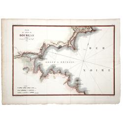
Plan du Golfe de BOURGAS.
A beautifully colored map, depicting the Bourgas gulf in Bulgaria. Taken from Pierre Lapie's work: "Reconnoissance nautique et militaire du Golfe de Bourgas", M...
Place & Date: Paris, 1809
Selling price: $100
Sold in 2019
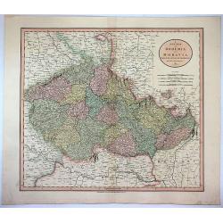
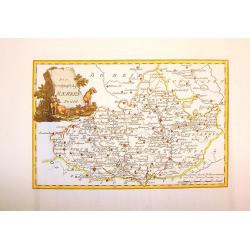
A New Map of Bohemia and Moravia from the Latest Authorities.
Attractive example of John Cary's 1811 map of Bohemia and Moravia. Covers the territory claimed by the modern day Czech Republic. Offers a great deal of detail and has p...
Place & Date: London, 1811
Selling price: $6
Sold in 2017
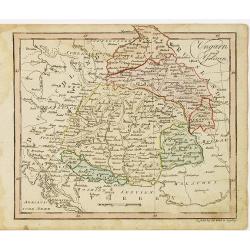
Ungarn und Galizien.
Nice small map of Hungary by Johannes Walch in his rare Allgemeiner Atlas Nach den bewährsten Hülfsmitteln und astronomischen Ortsbestimungen…, edition of 1812.Johann...
Place & Date: Augsburg, 1812
Selling price: $120
Sold in 2010
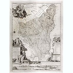
Mappa Dioecensis Alba-Regalensis . . .
Rare two sheet map of Albensis in Hungary, pre pared by Janor Pongratz, who was an Hungarian engraver and military cartographer and served as a lieutenant in the second R...
Place & Date: Budapest, ca. 1819
Selling price: $500
Sold in 2018
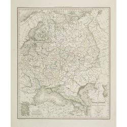
Russie d'Europe . . .
Detailed map of the European part of Russia, including the Black Sea region, prepared by A. H. Basset, rue Saint-Jacques, no. 64, Paris and published in Atlas classique e...
Place & Date: Paris, A.H. Basset, 1828
Selling price: $150
Sold in 2009
Lengyel Fold
Small Hungarian map of Poland and Lithuania. Major cities and towns depicted in red, mountains, rivers, woodlands and forests are also highlighted in color.
Place & Date: ca. 1830
Selling price: $55
Sold in 2016
Prag (without a title).
A rare, fascinating view of Prag, from the "Buchhandlung of A. Borroschs", engraved by J. Hyrtl in Vienna, 1830.
Place & Date: Vienna, 1830
Selling price: $190
Sold in 2018
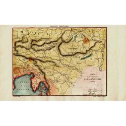
Carte de la Campagne de l'Armée D'Italie en 1809
Attractive and unusual steel engraved map illustrates the military activities in Austria, Hungary, and the Istria peninsula in 1809, during the Franco-Italian Napoleon fo...
Place & Date: Paris, c1835
Selling price: $40
Sold in 2008
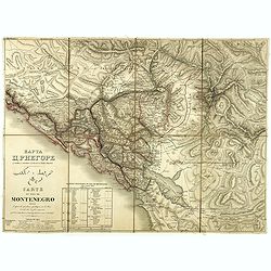
Carte du pays de Montenegro dressée d'après les opérations géodétiques . . .
A rare map of Montenegro, prepared by Mr. le Comte Fedor de Karacsay (1787-1859) and engraved by Pietro Allodi. The title is in Russian, Arabic, and French.In the lower-l...
Place & Date: Vienna, ca. 1838
Selling price: $1050
Sold in 2018
![[BALKANS 1839] HARTIS TIS TOYRKIAS KAI ELLADOS. . . BIENNI 1839.](/uploads/cache/85299-250x250.jpg)
[BALKANS 1839] HARTIS TIS TOYRKIAS KAI ELLADOS. . . BIENNI 1839.
A very rare copper engraved map of the southern Balkans - European Turkey and Greece, by K.M.Koyma, for the Greek edition of the Geography by A.Balbi, 1839 in Vienna. Cov...
Place & Date: Vienna, 1839
Selling price: $431
Sold in 2021
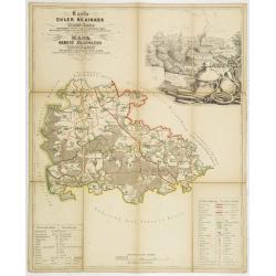
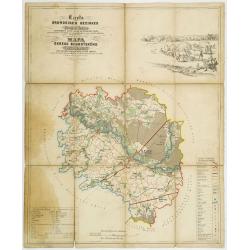
Karte des Euler Bezirkes im Prager Kreise zusammengestellt nach den neuesten und verlässchsten Quellen. . . / Mapa Okresu Jilovského v Prazskem kraji. . .
Uncommon folding map of Jilovského region. Printed in color lithography by J.Habel in Prague. Lithographed by J.Wagner. Decorative inset upper right of the Ringhoffer Ku...
Place & Date: Prague, J.Habel, c 1845
Selling price: $100
Sold in 2013
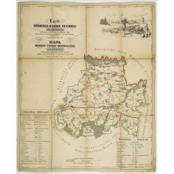
Karte des Pürglitzer bezirkes im Prager- Kreise. . . / Mapa Okresu Krivoklatského v Prazkém kraji. . .
Uncommon folding map of Krivoklatského region. Printed in color lithography by J.Habel in Prague. Lithographed by Jan Ed. Wagner. Decorative inset upper right with a ret...
Place & Date: Prague, J.Habel, c 1845
Selling price: $100
Sold in 2011
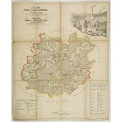
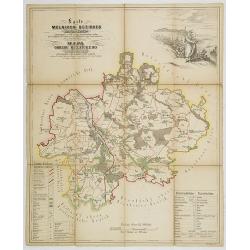
Karte des Welwarner Bezirkes im Prager Kreise zusammengestellt nach den neuesten und verlässchsten Quellen. . . / Mapa Okresu Velvarského v Prazskem kraji. . .
Uncommon folding map of Velvarského region. Printed in color lithography by J.Habel in Prague. Lithographed by J.Wagner. Decorative inset upper right of people harvestin...
Place & Date: Prague, J.Habel, c 1845
Selling price: $100
Sold in 2011
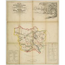
Karte des Brandeiser Bezirkes im Prager Kreise zusammengestellt nach den neuesten und verlässchsten Quellen. . . / Mapa Okresu Brandýského v Prazskem kraji. . .
Uncommon folding map of Brandýského region. Printed in color lithography by J.Habel in Prague. Lithographed by J.Wagner. Decorative landscape upper right and key in low...
Place & Date: Prague, J.Habel, c 1845
Selling price: $100
Sold in 2013
Karte des Böhmisch-Broder bezirkes im Prager- Kreise. . . / Mapa Okresu Cesko-Brodského v Prazkém kraji. . .
Uncommon folding map of Brodského region. Printed in color lithography by J.Habel in Prague. Lithographed by J.E.Wagner. Decorative landscape upper left with a hunting s...
Place & Date: Prague, J.Habel, c 1845
Selling price: $100
Sold in 2011
Karte des Melniker bezirkes im Prager- Kreise. . . / Mapa Okresu Mélnického v Prazkém kraji. . .
Uncommon folding map of Mélnického region with the rivers Moldova and the Elbe at Melník. Printed in color lithography by J.Habel in Prague. Lithographed by Jan Ed. Wa...
Place & Date: Prague, J.Habel, c 1845
Selling price: $100
Sold in 2011
Turquie d'Europe.
Detailed map of European Turkey, including Greece, Romania, Bulgaria, Bosnie, etc. Prepared by Charles V. Monin (fl.1830-1880) a French cartographer of Caen and Paris. Pu...
Place & Date: Paris, 1845
Selling price: $10
Sold in 2019

Djar Mougal de la Milice Lesghine Djar. 29
A very decorative print of a Moghul (also spelled Mughal) from the Lesghine militia after Prince Grigory Grigorievich Gagarin and lithographed by J.Keller. Printed by Lem...
Place & Date: Paris, A.Hauser, ca. 1846
Selling price: $150
Sold in 2012

LE CHAMKHAL de TARKY.
A very decorative print of a Chamkhal from Tarky in Dagestan after Prince Grigory Grigorievich Gagarin and lithographed by J.Keller. Printed by Lemercier in Paris. The li...
Place & Date: Paris, A. Hauser, ca. 1846
Selling price: $250
Sold in 2015
Turkey in Europe.
A very decorative steel-engraved map of South-East Europe, extending from Dalmatia until the Black Sea. Very detailed with place names, rivers, hills, bays, etc. With a s...
Place & Date: London, ca. 1850
Selling price: $15
Sold in 2017
Turkey in Europe.
Decorative steel engraved map of Albania, Macedonia, Romania, Bulgaria, Moldavia and the European part of Turkey with insets of the Bosporus and Constantinople and depict...
Place & Date: London, ca. 1851
Selling price: $230
Sold in 2011
Turkey in Europe.
A decorative steel engraved map of Albania, Macedonia, Rumania, Bulgaria, Moldavia and the European part of Turkey with insets of the Bosporus and Constantinople and depi...
Place & Date: London, ca. 1851
Selling price: $38
Sold in 2019
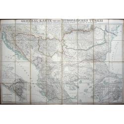
General-karte von der Europäischen Türkei nach allen vorhandenn originalkarten und itinerarischen hülfsmitteln bearbeitet und von Heinrich Kiepert
Place & Date: Berlin, Dietrich Reimer, 1853
Selling price: $490
Sold in 2008
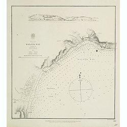
Black Sea - Baljik Bay surveyed by the officers of H.S.M.V. Spitfire 1854
of the Baljik Bay with in top a panoramic view of the town seen from the anchorage. The Baljik Bay is located in Southeastern Europe, bordering the Black Sea, between Ro...
Place & Date: London, after 1854
Selling price: $50
Sold in 2017
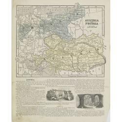
Austria and Prussia.
Map of Austria and Prussia. From Sidney E. Morse''s: System of Geography for the use of schools , published by Harper and brothers, 329 Pearl Street, New York.An 150 year...
Place & Date: New York, 1855
Selling price: $20
Sold in 2008
Diocesi e Vacariati Apostolici della Turchia, Grecia, Ed Isole Jonie (Tav XCIII)
A large-format map of Eastern Europe with its different dioceses. The map is finely engraved and beautifully colored and was prepared by Girolamo Petri, a lawyer who serv...
Place & Date: Rome, 1858
Selling price: $300
Sold in 2022
Province ecclesiastiche di Zagrabia e di Zara nell' Impero Austriaco (Tav LXXIII)
This large-format Zagrabia and Zara map is finely engraved and beautifully colored and was prepared by Girolamo Petri, a lawyer who served as a senior official within the...
Place & Date: Rome, 1858
Selling price: $200
Sold in 2020
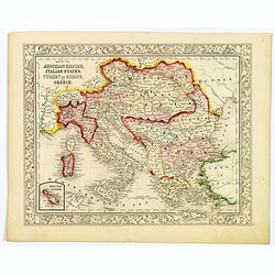
Map of the Austrian Empire, Italian States, Turkey in Europe, and Greece.
A nice example of S. A. Mitchell Jr.'s 1864 map of the Austrian Empire, Italy, Turkey in Europe and Greece. There is an inset in the lower-left corner that features the M...
Place & Date: Philadelphia, 1864
Selling price: $2
Sold in 2021
![Illustriss.mo et excell.mo domino domino [...] Viennam Austriae ...](/uploads/cache/46474-250x250.jpg)
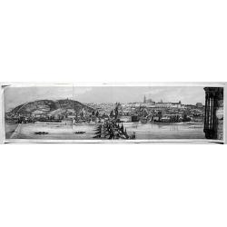
Illustriss.mo et excell.mo domino domino [...] Viennam Austriae ...
Rare separately issued circular bird's eye view of Vienna, published by Heinrich Schmidt and Albert Camesina in in Vienna. Showing a rounded view of the area outside of V...
Place & Date: Vienna, 1864
Selling price: $300
Sold in 2021
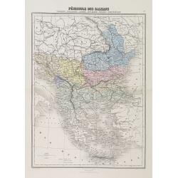
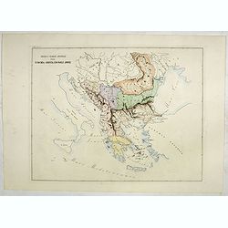
Péninsule des Balkans. Turquie -Roumanie - Serbie -Bulgarie - Bosnie - Monténégro.
A decorative map of the Balkan States (Romania, Serbia, Bulgaria, Bosnia and Montenegro) from Géographie Universelle, Atlas Migeon, published by J. Migeon.From one of th...
Place & Date: Paris, 1874
Selling price: $50
Sold in 2010
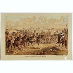
Einmarsch der russischen truppen in Romänien.
Showing the Russian arriving in Romaniia during the Russian-Turkish War (1828-1829) . Russian troops occupied Wallachia and Moldova for a few years.
Place & Date: Dresden, 1880
Selling price: $10
Sold in 2023
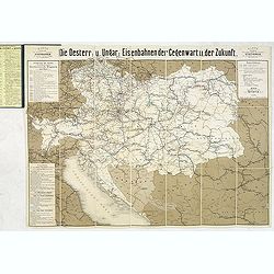
Die Österreichisch & Ungarischen Eisenbahnen der Gegewart und der Zukunst.
Rare rail-way folding map of Austria, Hungary and Galicia (centered on Lviv, or Lemberg ). Published in Vienna, by Artaria & Co. The firm was founded by the cousins C...
Place & Date: Vienna, 1881
Selling price: $110
Sold in 2013
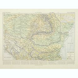
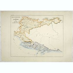
Etats Danubiens. . .
Map of east of Europe, showing Hongriae, Serbia, Bulgaria, Romania, Bosnia and part of the Black Sea up to Odessa. Text in French in lower part.This publication is in fac...
Place & Date: Paris, E.Capiomont,1894
Selling price: $100
Sold in 2014