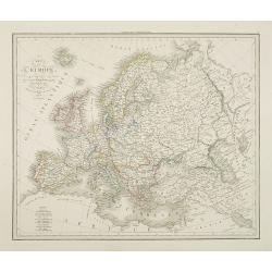
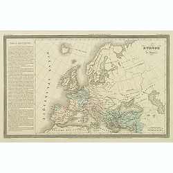
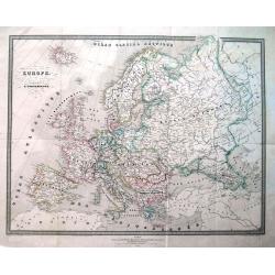
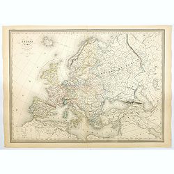
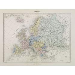
Carte de l'Europe . . .
Detailed map of Europe, prepared by A. H. Basset, rue Saint-Jacques, no. 64, Paris and published in Atlas classique et Universel de Géographie . . . .The engraver of the...
Place & Date: Paris, A.H. Basset, 1828
Selling price: $85
Sold in 2009
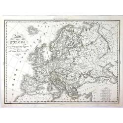
Carta Dell' Europa da Fare d'llustrazione al Nuovo Dizionario Geografico Universale....
A strikingly attractive and detailed copper engraved map of Antonelli's 1829 map of the whole European Continent. This large map provides excellent topographic details on...
Place & Date: Venice, 1829
Selling price: $27
Sold in 2016
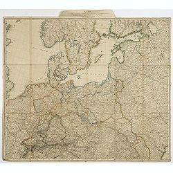
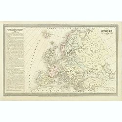
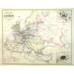
Karte des mittlern und östlichen Europa, von der Seine bis an der Dnieper. . .
Detailed map of the north west of Europe centered on Poland and Lithuania. The map is prepared by D.G. Reymann and published in Berlin by Simon Schropp & Co.A road sy...
Place & Date: Berlin, ca. 1830
Selling price: $100
Sold in 2018
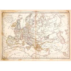
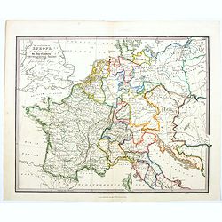
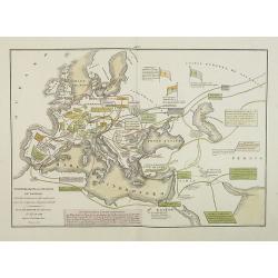
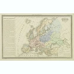
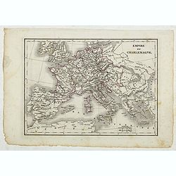
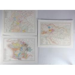
L'Europe a l'Epoque du Demembrement de L'Empire de Charlemagne.
Fine map featuring the empire of CHARLEMAGNE in Europe. It was developed by F. Delamarche in Paris in 1831. It was published in "ATLAS DE LA GEOGRAPHIE".
Place & Date: Paris, 1831
Selling price: $22
Sold in 2017
The Central Part of Europe for the Elucidation of the Abbe Gaultier's Geographical Games.
A detailed map of central Europe from A Complete Course of Geography, by Means of Instructive Games invented by the Abbé Gaultier included ‘numerous emendations and ad...
Place & Date: London, 1832
Selling price: $51
Sold in 2020
Europe aprés l'invasion des Barbares..
Ancient map of Europe in the 5th and 6th century.From Malte-Brun's Atlas G�ographie Universelle.., revised by Jean Jacques Nicolas Huot.This very fine executed map h...
Place & Date: Paris 1837
Selling price: $10
Sold in 2008
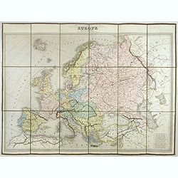
EUROPE Dressée par C.V. Monin.
Detailed map of Europe with different scales in lower right corner.Engraved by L.Grenier, Rue des Noyers, No. 33. and printed by Mangeon.Here the map is issued as a singl...
Place & Date: Paris, Armand Aubrée, ca. 1837
Selling price: $80
Sold in 2017
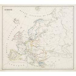
Europe - Mars 1839
Fine manuscript map of Europe with relief shown pictorially. The Oceans in wash color and the borders in different colors. Dated 1839 and signed by the author in the lowe...
Place & Date: Paris, 1839
Selling price: $50
Sold in 2009
Transmigrazioni ed invasioni de\' Barbari . . .
A rare double-page map of Barbarian invasion.According to the title cartouche, prepared by A de La Sage for l\'Atlante Storico, Letterario, Biografico, Archeologico. . . ...
Place & Date: Venice, 1840
Selling price: $80
Sold in 2009
L'Europa colle politiche divisioni nel 1827.
A rare and detailed double-page map of Europe. From l'Atlante Storico, Letterario, Biografico, Archeologico. . . with attributions by Giambatista Albrizzi.Upper left a k...
Place & Date: Venice, 1840
Selling price: $40
Sold in 2009
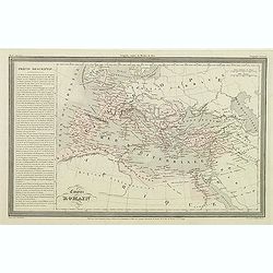
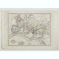
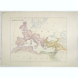
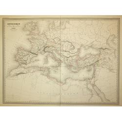
Impero Romano . . .
A rare double-page map of the Roman Empire. From l'Atlante Storico, Letterario, Biografico, Archeologico. . . with attributions by Giambatista Albrizzi.Lower part a key....
Place & Date: Venice, 1840
Selling price: $55
Sold in 2009
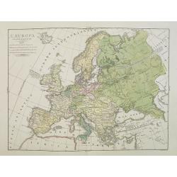
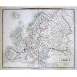
Europe.
Finely engraved map of Europe prepared by A.H.Dufour and engraved by Giraldon-Bovinet. Published by Jules Renouard in his uncommon atlas "Le globe Atlas classique Un...
Place & Date: Paris, Jules Renouard, ca.1840
Selling price: $25
Sold in 2015
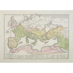
Empire romain.
Finely engraved map prepared by A.H.Dufour and engraved by Giraldon-Bovinet. Published by Jules Renouard in his uncommon atlas "Le globe Atlas classique Universel de...
Place & Date: Paris, Jules Renouard, ca.1840
Selling price: $20
Sold in 2016
Europe après l'invasion des Barbares.
Finely engraved map prepared by A.H.Dufour and engraved by Giraldon-Bovinet. Published by Jules Renouard in his uncommon atlas "Le globe Atlas classique Universel de...
Place & Date: Paris, Jules Renouard, ca.1840
Selling price: $30
Sold in 2016
Europe sous Charlemagne.
Finely engraved map prepared by A.H.Dufour and engraved by Giraldon-Bovinet. Published by Jules Renouard in his uncommon atlas "Le globe Atlas classique Universel de...
Place & Date: Paris, Jules Renouard, ca.1840
Selling price: $20
Sold in 2015
Europe sous Charlemagne.
Finely engraved map prepared by A.H.Dufour and engraved by Giraldon-Bovinet. Published by Jules Renouard in his uncommon atlas "Le globe Atlas classique Universel de...
Place & Date: Paris, Jules Renouard, ca.1840
Selling price: $25
Sold in 2016
Empire Romain.
Detailed map of Europe and North Africa, prepared by Charles V. Monin (fl.1830-1880) a French cartographer of Caen and Paris. Published in Atlas Universel de Géographie ...
Place & Date: Paris, 1845
Selling price: $5
Sold in 2022
Empire de Charlemagne.
Detailed map of Europe, prepared by Charles V. Monin (fl.1830-1880) a French cartographer of Caen and Paris. Published in Atlas Universel de Géographie Ancienne &c M...
Place & Date: Paris, 1845
Selling price: $5
Sold in 2022
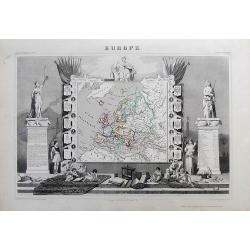
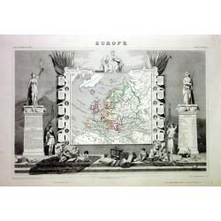
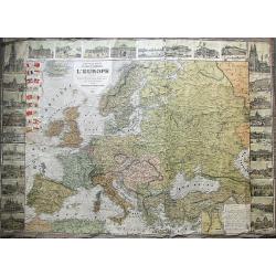
EUROPE
Charming map of the continent, surrounded by coats of arms (France, England, Spain, Italy, Switzerland, Russia, Prussia, Germany, Turkey...). Columns on the sides contain...
Place & Date: Paris, 1849
Selling price: $64
Sold in 2012
Europe.
While the map itself is quite simple without a great deal of detail, the surrounding engravings make this one of the most decorative 19th century maps. The map is framed ...
Place & Date: Paris 1850
Selling price: $100
Sold
![[Untitled map of the Mediterranean countries in a playing grid].](/uploads/cache/23365-250x250.jpg)
[Untitled map of the Mediterranean countries in a playing grid].
Small, accurate map centered on the Mediterranean Basin with the adjacent countries, embedded in a square playing grid formed by 100 cells.The map presumably represents t...
Place & Date: France, ca. 1850
Selling price: $50
Sold in 2009
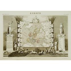
Europe
Very decorative steel-engraved map of Europe. Ornately decorated with medallion portraits of the heads of European Countries and their respective heraldic arms, Scales o...
Place & Date: Paris, 1850
Selling price: $50
Sold
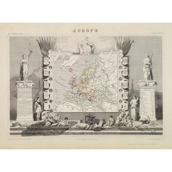
Europe.
A very decorative 19th century map showing Europe. The map is surrounded by portraits and coat of arms of European countries, cherubs, vegetation, etc.A very popular and ...
Place & Date: Paris 1850
Selling price: $100
Sold
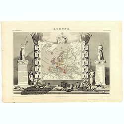
Europe.
A very decorative 19th century map showing Europe. The map is surrounded by portraits and coat of arms of European countries, cherubs, vegetation, etc..
Place & Date: Paris 1850
Selling price: $180
Sold
![[Untitled map of the European countries in a playing grid].](/uploads/cache/32644-250x250.jpg)
[Untitled map of the European countries in a playing grid].
Small, accurate lithographed map of Europe, embedded in a square playing grid formed by 100 cells.The map presumably represents the extension of the territories under Rom...
Place & Date: France, ca. 1850
Selling price: $75
Sold in 2014
Europe.
While the map itself is quite simple without a great deal of detail, the surrounding engravings make this one of the most decorative 19th century maps. The map is framed ...
Place & Date: Paris, 1850
Selling price: $80
Sold in 2023
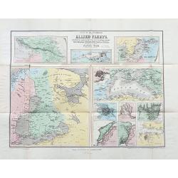
Scene of the operations of the Allied Fleets.
Scarce folding map with 11 maps showing various parts and cities. Including Caucasian Isthmus, Kronstadt, the Baltic Sea, Black Sea, St. Petersburg, the mouth of the Danu...
Place & Date: London, ca. 1851
Selling price: $100
Sold in 2023
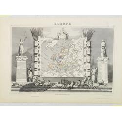
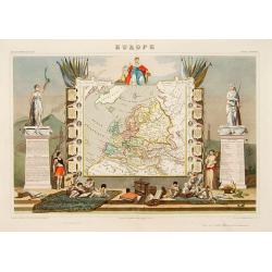
Europe.
Map of Europe, framed by medallion portraits and coats of arms down each side and is set against a background of statues and allegorical figures. A large group of adorabl...
Place & Date: Paris, A. Combette, 1852
Selling price: $80
Sold in 2009
Carte Generale dell Europa Divisa ne Suoi Principali Stati.
A pleasing map of Europe by Cassella, published in Turin in 1855.
Place & Date: Turin, 1855
Selling price: $26
Sold in 2017
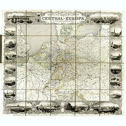
Karte von Central-Europa.
Steel engraved wall map printed from 4 plates by Albert Henry Payne, active in Leipzig and Dresden, dated 1856.Showing The Low Countries, Germany, Prussia, Poland, Denmar...
Place & Date: Leipzig, Dresden, 1856
Selling price: $1500
Sold in 2018
Carte de L'Empire D'Autriche Pour Servir a L'Histoire des Races Bovines (3 Maps.)
An interesting set of three maps showing the species of cow in France, Austria and Germany. Each map has a legend with a color code representing each species. Published b...
Place & Date: Paris, 1857
Selling price: $17
Sold in 2019
Patriarcati Antichi (Tav II)
This large-format Europe map is finely engraved and beautifully colored and was prepared by Girolamo Petri, a lawyer who served as a senior official within the Vatican’...
Place & Date: Rome, 1858
Selling price: $500
Sold in 2020
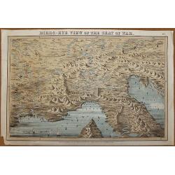
Birds - Eye View of the Seat of War...No1.
An interesting birds eye view of Europe from Paris to Vienna and Marseilles to Ancona. Published May 18th 1859 by R. McMichael, 5 Adam Street, East Portman Square, London...
Place & Date: London, 1859
Selling price: $185
Sold in 2017
Europa.
Uncommon map of Spain and Portugal. Lithography by J.H. van Weijer, published in Atlas der geheele Aarde [?] in 24 kaarten.
Place & Date: Groningen, ca. 1860
Selling price: $30
Sold in 2008
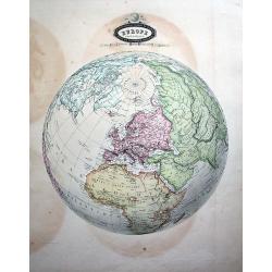
Europe Sphéroïdale.
Uncommon map of the sphere, centered on Europe. Extending until South America, Madagascar, South-East Asia, and Alaska (Russian America!) A rare and decorative map!
Place & Date: Paris, 1860
Selling price: $90
Sold in 2010
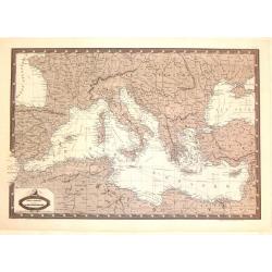
Carte Generale du Bassin de La Mer Mediterranee.
Detailed map of the Mediterranean and surrounding regions. It comes from "ATLAS SPHEROIDAL & UNIVERSEL DE GEOGRAPHIE". published in Paris by Jules Renouard ...
Place & Date: Paris, 1860
Selling price: $15
Sold in 2016
Empire Romain
The Roman Empire, from Atlas Universel Physique, Historique, Politique de Géographie Ancienne et Moderne printed by Louis Antoine and published by Armand le Chevalier in...
Place & Date: Paris, 1861
Selling price: $15
Sold in 2011
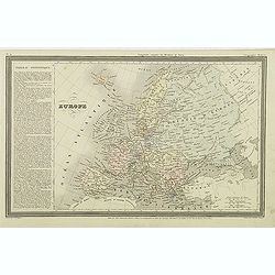
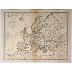
Europe.
Interesting map of Europe with its geography and territories around 1861! Published by Dufour. A large and detailed map with attractive coloring indicating the borders.
Place & Date: Paris, 1861
Selling price: $50
Sold in 2013
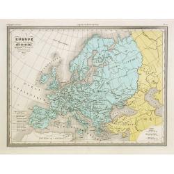
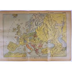
Europe en 1789 (1861).
A large, highly significant and detailed map of Europe as it appeared in 1789 - on the very eve of the French revolution - something that would have a profound and lastin...
Place & Date: Paris, 1861
Selling price: $8
Sold in 2020
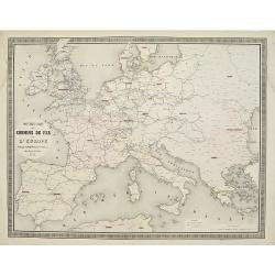
Nouvelle carte des chemins de fer de Europe.
Detailed map of Europe showing its railway systems at this early stage.From Atlas des Chemins de Fer published by Napoléon Chaix and printed by Imprimerie et librairie c...
Place & Date: Paris 1863
Selling price: $115
Sold in 2011
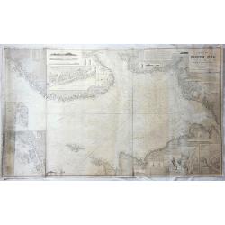
Chart of the North Sea Comprising All the Modern Surveys Drawn by J.S. Hobbs.
A fine antique working nautical chart of the North Sea by Norie, published in London in 1866. It was published by Charles Wilson (Late J.W. Norie and Wilson). The seller...
Place & Date: London, 1866
Selling price: $450
Sold in 2018
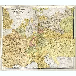
Special-Karte der Eisenbahn- Post- u. Dampfschiff-Verbindungen Mittel-Europa's - mit Angabe aller Eisenbahn-, Post- u. Dampfschiffstationen, Speditionsorte, Zoll- u. Steuerämter, Bäder, Mineralquellen
Gigantic wall map of Central Europe showing rail way, post routes and ship routes, prepared by C.J.C. Raab and edited by H. Müller. More about folding maps. [+]
Place & Date: Glogau, C.Flemming, 1870
Selling price: $300
Sold in 2017
Europe.
A decorative map of Europe from Géographie Universelle, Atlas Migeon, published by J. Migeon.From one of the last decorative atlases published in the 19th century.
Place & Date: Paris, 1874
Selling price: $20
Sold in 2012
Nouvelle carte des voies de communication de l'Europe par des chemins de fer et la Navigation maritime.
Uncommon map of Europe showing the rail way system, steamboat routes connecting the European cities. Inset maps of London and Paris and a color key in lower left. Publish...
Place & Date: Paris, 1876
Selling price: $250
Sold in 2011
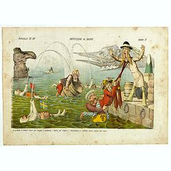
Impressioni al Bagno. Papagallo No. 28. Anno V.
Showing a Russian preventing an English figure leaving the sea by pulling a sharp of John Bull. Italian, American, Indian, Istanbul representations in the sea. Taken from...
Place & Date: Bologne, 1877
Selling price: $205
Sold in 2018

Il colosso di Rodi. Papagallo No. 41. Anno V.
Satirical plate published in the supplement to the political newspaper charivaric Papagallo / Le Perroquet N. 41, in the 5th year of publication, published in Bologna. Th...
Place & Date: Bologne, 1877
Selling price: $850
Sold

La Piovra Russa. Carta Serio-Comica Pel 1878.
Very rare political caricature map by Grossi of the nations of Europe, published in Bologna in the supplement of the newspaper "Le Perroquet / Al papagallo, N° 15, ...
Place & Date: Bologne, 14 avril 1878
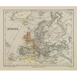
Europe.
Map of Europe.
Place & Date: Edinburgh, 1880
Selling price: $1
Sold in 2010
Plans of the most important cities and towns of continental Europe accompanying the special edition of Bradshw's continental railway, steam transit, &c. Guide and general handbook.
Including plans of Paris, Lyon, Marseilles, Ostend, Ghent, Brussels, Antwerp, The Hague, Cologne, Mayence, Frankfort on the Maine, Dresden, Hamburg, Munich, Berlin, Tries...
Place & Date: Birmingham, 1880
Selling price: $210
Sold in 2020
![CEUX QUI BOUDENT L'EXPOSITION [THOSE WHO SHUN THE EXPOSITION].](/uploads/cache/85250-250x250.jpg)
CEUX QUI BOUDENT L'EXPOSITION [THOSE WHO SHUN THE EXPOSITION].
A chromolithograph, satirical map of Europe on the mostly negative reactions of the European nations against France ,which held the great international exposition in 1889...
Place & Date: Paris, 1889
Selling price: $68
Sold in 2021
Nouvelle carte politique et commerciale de l'Europe indiquant toutes les communications maritimes, chemins de fer, et les changements des nouvelles limites des Etats d'Orient.
A large and very rare map of Europe, indicating various travelling routes. Decorated with 28 views of buildings and places in major cities such as Paris, Hamburg, Milan, ...
Place & Date: Paris, 1890
Selling price: $140
Sold in 2019
![[Lot of 2 maps] Europa in Rilievo / Italia in Rilievo.](/uploads/cache/48404-250x250.jpg)
[Lot of 2 maps] Europa in Rilievo / Italia in Rilievo.
A pair of maps published by Roux & Company in Turin during the last years of the 19th century. The map of Europe was presented as a 'Gift from the Piedmont Gazette'. ...
Place & Date: Turin, 1886-1890
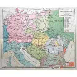
Völker-u. Sprachen-Karte von Mitteleuropa.
Interesting thematic map illustrating the nations and languages of central Europe, from Brussels to the Black Sea. Published by Artaria in Vienna.
Place & Date: Vienna, 1893
Selling price: $20
Sold in 2016
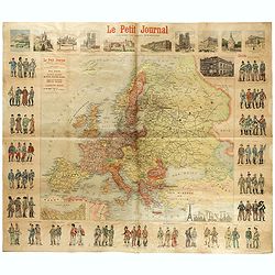
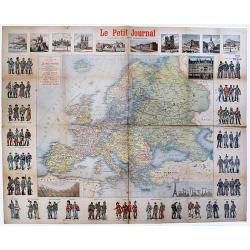
Le Petit Journal - Uniforme des armées Européennes.
French wall map sized map of Europe taken from the famous newspaper Le Petit Journal Illustré, showing the different army uniforms types in Europe, with a map of Europe....
Place & Date: Paris, circa 1895
Selling price: $300
Sold in 2017
L'Europe vue par un aeronaute impressionnable.
A rare satirical map of Europe, published in the French magazine Le Pélerin N° 1054 on March 14th, 1897. color printed, with French text on verso.More about cartographi...
Place & Date: Paris, 1897
Selling price: $280
Sold in 2017
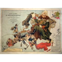
Angling in Troubled Waters A Serio-Comic Map of Europe by Fred. W. Rose Author of the 'Octopus Map of Europe' 1899.
One of the most famous serio-comic maps. A chromolithographed large caricature map of Europe with each country depicted as an angler having various levels of success in h...
Place & Date: London, 1899
Selling price: $1950
Sold in 2021
Carte de l'Europe Publieépar Le Petit Journal. . .
A rare map of Europe. An interesting and very detailed map of Europe at ca.1900, designed by A. Guibal, and engraved and printed by Charaire et Cie as a separately publis...
Place & Date: Paris, ca 1900
Selling price: $400
Sold in 2020
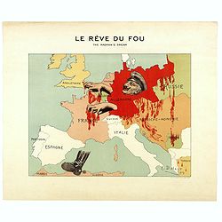
Le Rève du Fou. The madman's dream.
Scarce French satirical map of Europe in 1914 produced by A. Delaye and printed in colors by Ch. Delaye in Paris.
Place & Date: Paris, 1914
Selling price: $300
Sold in 2018
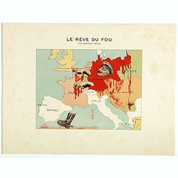
Le Rève du Fou. The madman's dream.
Scarce French satirical map of Europe in 1914 produced by A. Delaye and printed in colors by Ch. Delaye in Paris. Signed and dated in the plate.The map of Europe figures ...
Place & Date: Paris, 1914
Selling price: $300
Sold in 2018

Mappa Humoristico da Europa.
A really unusual and lovely map, published in Portugal at the outbreak of The Great War in 1914. This outbreak of war in Europe was the result of a complex sequence of ev...
Place & Date: Lisbon, 1914
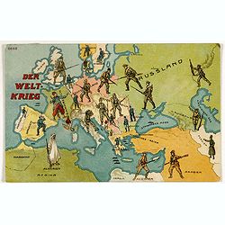
Der Weltkrieg. World War I post card)
During the Great War, when the only means of communicating news to the masses was by newspapers and weekly illustrated magazines, the ‘war’ or 'military' picture post...
Place & Date: Germany, 1915
Selling price: $60
Sold in 2018
![[Europe.]](/uploads/cache/82027-250x250.jpg)
[Europe.]
A very rare satirical map (postcard) showing Europe during first World War.
Place & Date: Marseille, 1918
Selling price: $100
Sold in 2020
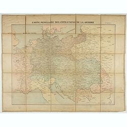
Carte populaire des opérations de la guerre. 2ème édition.
Folding map. War Operations Map showing a part of Europe, published by Epinal.
- $150 / ≈ €140
Place & Date: Paris, ca. 1919
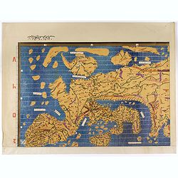
Single sheet from Tabula Rogeriana world map with European section.
Separate single sheet (of 6) with the European section of the [TABULA ROGERIANA] [NUZHAT AL-MUSHTĀQ FI'KHTIRĀQ AL-ĀFĀQ - THE BOOK OF P...
Place & Date: Suttgart, Konrad Miller, 1928
Selling price: $110
Sold in 2017
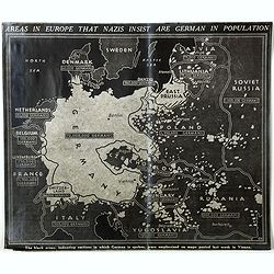
Areas in Europe that nazis insist are German in population . . .
A English propaganda broadsheet, showing a map of Europe. In the bottom "The black areas, indicating sections in which German is spoken, were emphasized on maps post...
Place & Date: England, c. 1938
Selling price: $220
Sold in 2018
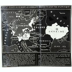
Focal points in Europe as Germany drives to end the status quo.
A very rare English propaganda broadsheet, showing a map of Europe. In the bottom a legend text corresponding to each number on the map. "Nazi agitators demand the r...
Place & Date: England, c. 1938
Selling price: $200
Sold in 2018

L'Europe en Sept 1939. Ille terrarum mihi angulus ridet.
A rare oversized serio-comic map of Europe at the start of the Second World War depicting stereotypes of 31 countries, as listed in the key lower right, including Brit...
Place & Date: Bruges, Leon Burghgraeve, 1939

Target Berlin
This large map (broadside) is formally entitled Newsmap. Monday, October 25, 1943, Vol. II No. 27. By F. E. Manning, it is one of the most iconic American WWII propaganda...
Place & Date: Washington D.C., 1943
Selling price: $400
Sold in 2023
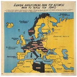
TERRITORIAL GAINS OF THE AXIS POWERS END OF 1940 (WWII Greek Language Propaganda Map)
Hitler, having remedied all losses suffered by Germany under the Treaty of Versailles, started to bring under the authority of the Third Reich all German-speaking peoples...
Place & Date: Alexandria, 1945
Selling price: $120
Sold in 2021
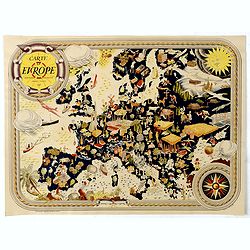
Carte D'Europe - Editions Jacques Petit.
Very decorative large pictorial map of Europe designed in 1946 by Pierre Herault and published in Angers by Editions Jacques Petit in 1955. The separate issued map shows ...
Place & Date: Angers, 1946
Selling price: $165
Sold in 2019
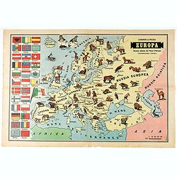
Europa - Grande Atlante dei Paesi d'Europa Ventiduesima Tavola.
Pictorial map of Europe, showing wild animals living in each country. On verso Italian text and photo's.
Place & Date: Italy, 1956
Selling price: $50
Sold in 2020