![[Map of Europe]](/uploads/cache/31501-250x250.jpg)
[Map of Europe]
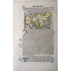
Page with an early representation of Europe. This text page with a fine wood block printed map is from the rare work "C. Iulii Solini Polyhistor, Rerum Toto Orbe Mem...
Place & Date: Basle, Michael Isengrin, 1544
Selling price: $225
Sold in 2013
Von dem Europa, das zu unsern zeiten die Christenheit under im begreifft und etwas von der Türkey.
An attractive map of Europe from the famous 'Cosmographia' by Sebastian Münster, in very nice colors. Europe has almost already taken the shape of Regina Europa. On ve...
Place & Date: Basel, 1544
Selling price: $100
Sold in 2022
Europa, das ein Drittheil der Erden, nach gelegenheit unsern zeiten
Attractive woodcut map showing the European continent with South on top. From a German edition of Cosmographia by Sebastian Munster printed from Petri in Basel around 154...
Place & Date: Basle, 1545
Selling price: $500
Sold in 2009
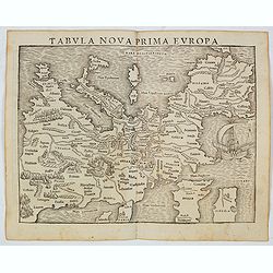
Tabula Nova Prima Europa. (Europe - 1st edition)
The FIRST edition of Munster's first modern map of Europe, with south oriented at the top which appeared in his "Geographia Universalis", first published in 154...
Place & Date: Basel, Heinrich Petri, 1545
Selling price: $300
Sold in 2022
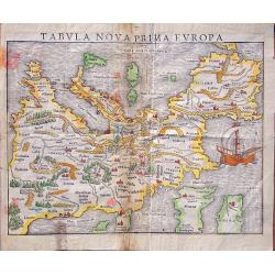
Tabula nova prima Europa.
This map comes from The first edition of Munster's "Geographia Universalis", first published in 1540. It is thus the first modern map of Europe, with south orie...
Place & Date: Basel, Heinrich Petri, 1545
Selling price: $1090
Sold in 2014
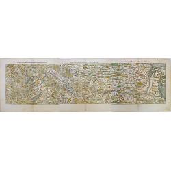
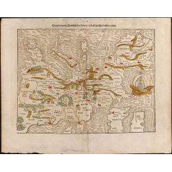
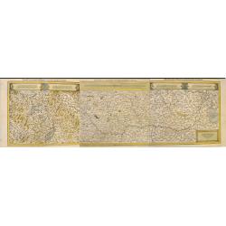
Die erst Tafel, innhaltend das Schweytzerlandt, mit den anstossenden Ländern / Die ander Tafel des Rheinstroms, begreiffend die Pfaltz, Westereich, Eyfel ec. . .
A monumental map of the course of the Rhine river. This is a three-sheet woodcut map showing the Rhine from the headwaters in Switzerland to its mouth in the North Sea. T...
Place & Date: Basel, H.Petri, ca. 1550
Selling price: $375
Sold in 2020
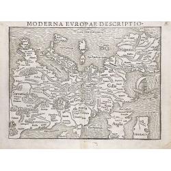
Moderna Evropae descriptio.
This important map represents one of the first printed maps of the European continent as a whole. Printed initially around 1550 in the famous Cosmographia, it was then re...
Place & Date: Basel, ca. 1550
Selling price: $700
Sold in 2013
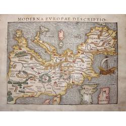
Moderna Evropa descriptio.
At the time Sebastian Münster published this map, it was not yet conventional to orient the North at the top. The uncommon orientation to the South for this map was deri...
Place & Date: Basle, 1550
Selling price: $1650
Sold in 2013
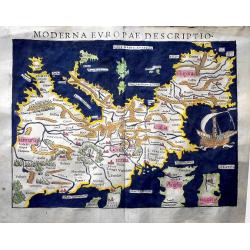
Moderna Evropae Descriptio.
One of the first printed maps of the European continent as a whole. Initially, it appeared in the famous Cosmographia (CIRCA 1550) and then re-issued several times before...
Place & Date: Basel, circa 1550
Selling price: $2100
Sold in 2015
Die erst Tafel, innhaltend das Schweytzerlandt, mit den anstossenden Ländern / Die ander Tafel des Rheinstroms, begreiffend die Pfaltz, Westereich, Eyfel ec. . .
A monumental map of the course of the Rhine river. The three-sheet woodcut map showing the Rhine from the headwaters in Switzerland to its mouth in the North Sea. The map...
Place & Date: Basel, H.Petri, ca. 1550
Selling price: $325
Sold in 2020