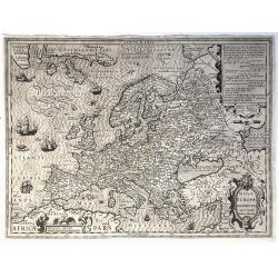
Nova Europae Descriptio.
A fine uncolored version of Hondius' second map of Europe, first issued in 1606. From: Jodocus Hondius, 'Atlas sive cosmographicæ meditationes de fabrica mundi et fabric...
Place & Date: Amsterdam, 1621-/23
Selling price: $615
Sold in 2020
![[Northern Europe with Poland]](/uploads/cache/90950-250x250.jpg)
[Northern Europe with Poland]
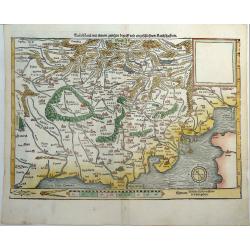
Map of Northern Europe and centered on Poland. First issue, with Latin text colophon and date on verso. The map is deemed to be the first printed map of Germany, even if ...
Place & Date: Nuremberg, 12 July 1493
Selling price: $2000
Sold in 2016
![[Germania Magna]](/uploads/cache/92822-250x250.jpg)
[Germania Magna]
Map of Northern Europe and centered on Poland. First issue, with Latin text colophon and date on verso. The map is deemed to be the first printed map of Germany, even if ...
Place & Date: Nuremberg, 1493
Selling price: $3100
Sold in 2013
![[Northern Europe with Poland]](/uploads/cache/36852-250x250.jpg)
[Northern Europe with Poland]
Map of Northern Europe and centered on Poland. First issue, with Latin text colophon and date on verso. The map is deemed to be the first printed map of Germany, even if ...
Place & Date: Nuremberg, 12 July 1493
Selling price: $6200
Sold in 2016
![[Germania Magna].](/uploads/cache/98756-250x250.jpg)
[Germania Magna].
A woodcut colored map of northern and central Europe. The first modern map of the area. Second printed map of the North, after the woodcut map published in the 'Ulm' Ptol...
Place & Date: Nuremberg, 1493
Selling price: $5800
Sold in 2017
![[Northern Europe with Poland.]](/uploads/cache/81098-250x250.jpg)
[Northern Europe with Poland.]
A map of Northern Europe and centred on Poland. First issue, with Latin text colophon and date on verso. The map is deemed to be the first printed map of Germany, even if...
Place & Date: Nuremberg, 1493
Selling price: $4700
Sold in 2018
![Anglia / Hispania [England and Spain, two views on one page]](/uploads/cache/84790-250x250.jpg)
Anglia / Hispania [England and Spain, two views on one page]
Incunable sheet with two woodcut engravings of imaginary Views of 'Anglia'/England or Great Britain, and 'Hispania'/Spain on the back [Please view additional picture From...
Place & Date: Nuremberg, 1493
Selling price: $150
Sold in 2020
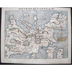
Europae Tabula
At the time Sebastian Münster published this map, it was not yet conventional to locate the North at the top of the map. Münster‘s orientation to the South was taken ...
Place & Date: Basle, 1540
Selling price: $800
Sold in 2015
TEÜTSCHLAND MIT SEINEM GANTZEN BEGRIFF UND EINGSCHLOSZNEN LANDSCHAFFTEN.
A very rare state of Europe or Germany by Sebastian Münster, unlike most maps of Germany from the Cosmographia. Attractively colored and oriented to the South. Showing t...
Place & Date: Basel, ca 1540
Selling price: $350
Sold in 2019
![[Map of Europe]](/uploads/cache/31463-250x250.jpg)
[Map of Europe]
Page with an early representation of Europe. The continent is filled with the Alps mountains and the rivers Rhine and Danube.This text page with a fine wood block printed...
Place & Date: Basle, Michael Isengrin, 1544
Selling price: $500
Sold in 2011