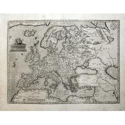
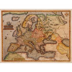
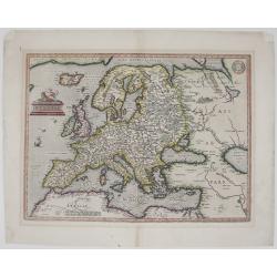
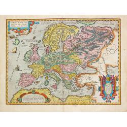
EUROPAE.
Europe map from the 1595 Latin edition of "Theatrum Orbis Terrarum", with not many copies in circulation. Latin text on verso of one half of the sheet.1579L(A)2...
Place & Date: Antwerp, 1579
Selling price: $800
Sold in 2018
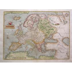
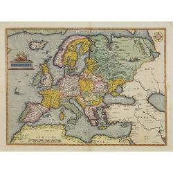
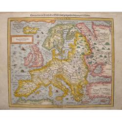
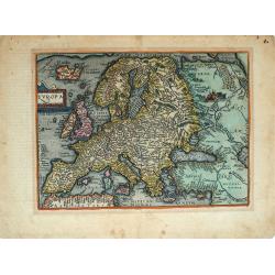
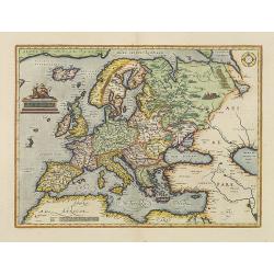
Europae.
A classic map of Europe derived from Mercator's work; Russia from Jenkinson's map; Scandinavia from Olaus Magnus. The relatively modest cartouche shows a partially covere...
Place & Date: Antwerp, 1579
Selling price: $1000
Sold in 2013
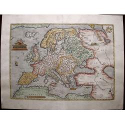
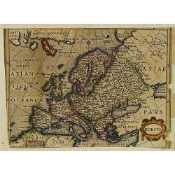
Europae.
Beautifully colored map of the Europe from the 1579 edition of Ortelius’Theatrum Orbis Terrarum, the first modern atlas of the world. Ortelius’ map of Europe became t...
Place & Date: Antwerp, 1579
Selling price: $900
Sold in 2015
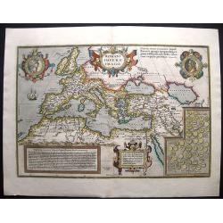
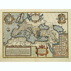
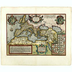
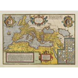
ROMANI IMPERII IMAGO.
A highly decorative map of Europe, from Abraham Ortelius' Theatrum Orbis Terrarum, the first modern atlas of the world. This image of Europe and its history was developed...
Place & Date: Antwerp, ca. 1579
Selling price: $600
Sold in 2017
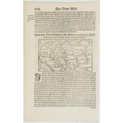
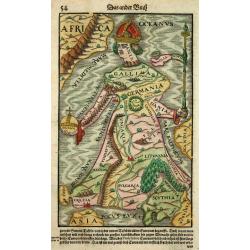
Von dem Land Europa. . .
Early map of Europe. From his Cosmographia, that great compendium of Renaissance knowledge. An exciting print.Sebastian Münster was born in Nierder-Ingelheim, near Mainz...
Place & Date: Basle 1550-1580
Selling price: $70
Sold in 2008
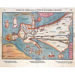
Evropa prima pars terrae in forma virginis.
This map, from Heinrich Bünting's Itinerarum Sacrae Scripturae, is based upon the map of Europa by Sebastian Munster Cosmographia. But even before, in 1537 the Tirolese ...
Place & Date: Magdeburg, 1581
Selling price: $1750
Sold in 2012
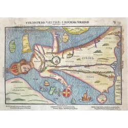
Europa prima pars terrae in forma virginis.
Europe is depicted in the form of a Queen. One of the earliest allegorical maps, appeared in the theologian Heinrich Bünting Itinerartum Sacrae Scripturae, a book mainly...
Place & Date: Magdeburg, after 1581
Selling price: $950
Sold in 2013
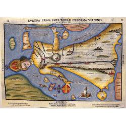
Europa Prima Pars Terrae in Forma Virginis.
In this fascinating map, Europe is depicted in form of a Queen, following the example of Munster's 'Cosmographia'. It is one of the earliest allegorical maps, it appeared...
Place & Date: Magdeburg, after 1581
Selling price: $500
Sold in 2017
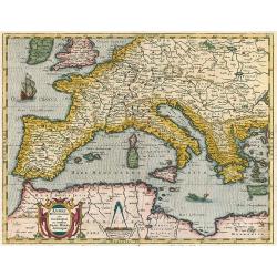
Europae.
Somewhat distorted land masses: vignette of Europe being carried off by the bull (Zeus).The second plate with title AFRICAE PARS now in Italic lettering.
Place & Date: Antwerp 1584
Selling price: $2325
Sold
Europae.
Somewhat distorted land masses: vignette of Europe being carried off by the bull (Zeus).The first plate with title AFRICAE PARS in normal lettering. Fine impression.The m...
Place & Date: Antwerp, 1584
Selling price: $1500
Sold in 2013
Romanii Imperii Imago.
An attractive map of the second plate prepared (after 1592) of the Roman Empire, drawn by Ortelius and published in the 'Paregon' section. The medallion portraits are of ...
Place & Date: Antwerp, 1584
Selling price: $800
Sold in 2012
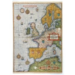
Universe Europe Maritime Eiusque Navigationis Descritio. Generale Pas chaerte van Europa. . . 1583.
The rare first plate of Waghenaer's general sea chart of Europe, dated 1583, with Latin text on verso; from the first Latin text edition, published in Leiden: Frans van R...
Place & Date: Enkhuizen, 1586
Selling price: $14800
Sold in 2017
Europa, das ein drittheil der erden, nach gelegenheit unserer zeit beschrieben.
Decorative full color example of Munster's final map of Europe, from a German edition of Munster's Cosmographia, one of the most influential geogaphical works of the 16th...
Place & Date: Basle, S. H. Petrie, 1588
Selling price: $400
Sold in 2013
![[Europe] Europa das ein Drittheil der Erde nach gelegenheit unserer zeit beschrieben.](/uploads/cache/34182-250x250.jpg)
[Europe] Europa das ein Drittheil der Erde nach gelegenheit unserer zeit beschrieben.
Decorative example of Munster's final map of Europe, from a German edition of Munster's Cosmographia, one of the most influential geographical works of the 16th Century. ...
Place & Date: Basle, S.H.Petri, 1588
Selling price: $210
Sold in 2014
![[Europe]](/uploads/cache/32516-250x250.jpg)
[Europe]
On verso an early wood block printed map of Europe.From a Latin text edition of his Geographia , that great compendium of Renaissance knowledge.
Place & Date: Basle, 1550-1590
Selling price: $115
Sold in 2013
Europa Prima Pars Terrae Forma Virginis.
Desirable, famous and extremely rare issue of this famous map of Europe, depicted in the form of a Queen wearing her crown and in flowing robes.This is a very rare issue...
Place & Date: Magdeburg, ca. 1592
Selling price: $3200
Sold
Universe Europae Maritime Eiusque Navigationis Descriptio. Generale Pascaerte van Europa . . .
This general chart of western Europe and the surrounding coastal waters is from the rare pilot-guide Spieghel der Zeevaerdt ,first printed by Christopher Plantin in Leyde...
Place & Date: Amsterdam, 1592
Selling price: $20490
Sold in 2015
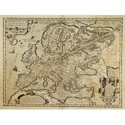
Nova totius Europae tabula.
Very rare map of the continent of Europe, with in top a dedication to Theodor Echter von Mespelbrunn. With an oversized Nova Zemla, including the fictions island "Fr...
Place & Date: Antwerp 1593
Selling price: $5000
Sold
Nova totius Europae tabula.
Very rare map of the continent of Europe, with in top a dedication to Theodor Echter von Mespelbrunn. With an oversized Nova Zemla, including the fictions islands of the ...
Place & Date: Antwerp, 1593
Selling price: $6750
Sold in 2011
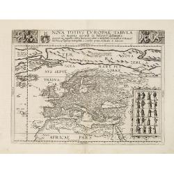
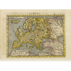
Europam, Sive Celticam Veterem.
Possibly derived to some extent from Ortelius' own two sheet map of the Roman Empire, which appeared in 1571. Further, this map is based on classical sources, such as Sal...
Place & Date: Antwerp 1595
Selling price: $390
Sold
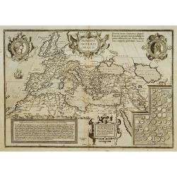
ROMANI IMPERII IMAGO.
The medallion portraits are of Romulus and Remus -the genealogical 'tree' describes the lineage of the Roman emperors while the strapwork bordered panels explain the hist...
Place & Date: Antwerp 1595
Selling price: $435
Sold
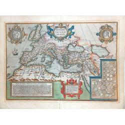
ROMANI IMPERII IMAGO.
Very decorative map of the ancient Roman empire. The medallion portraits Romulus and Remus.This map belongs to a series of historical maps known as the "Parergon The...
Place & Date: Antwerp 1595
Selling price: $650
Sold in 2013
Europa.
Map of Europe, including great part of northern Africa and the Near East.The map comes from a scarce pirate edition published by Petrus Keschedt in Cologne one year after...
Place & Date: Cologne 1597
Selling price: $200
Sold
Europa Regina
This is one of the most famous of cartographic oddities showing Europe in the shape of a woman. The representation of Europa Regina or Queen of Europe, was first drawn by...
Place & Date: Basel 1598
Selling price: $950
Sold
Romani Imperii Imago.
An attractive map of the second plate prepared (after 1592) of the Roman Empire, drawn by Ortelius and published in the 'Paregon' section. The medallion portraits are of ...
Place & Date: Antwerp, 1598
Selling price: $700
Sold in 2018
Europa.
Fascinating, scarce early map of the Europe from Quad's Europae totius orbis terrarum, published by Johann Bussemacher. Quad's map is a fantastic amalgam of many cartogr...
Place & Date: Cologne, 1598
Selling price: $365
Sold in 2019
Europae
Nice colored Ortelius’ map of Europe. This is the second edition, which was first issued in 1584 and can be distinguished from the earlier editions by the inclusion of ...
Place & Date: Antwerp, 1598

Gallia.
Extremely rare map of France, Netherlands, Southern England, Switzerland, and Northern Spain. This map was never regularly included in the Theatrum; Denuce mentions the i...
Place & Date: Antwerp, ca 1598
Europa primi pars terrae in forma Virginis septentrio.
Desirable, famous and relatively scarce-to-rare item usually deemed a curiosity or oddity map. All of Europe is depicted in the form of a Queen wearing her crown and in f...
Place & Date: Magdeburg, ca 1581-1600
Selling price: $2750
Sold
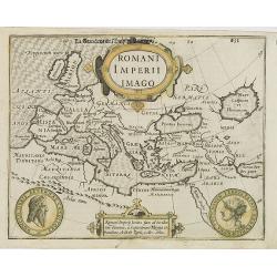
Romani Imperii Imago.
Early map showing the Roman Empire, from the first French-text edition of Jodocus Hondius'' Atlas Minor.Shortly after the publication of the big folio-atlases the need wa...
Place & Date: Amsterdam, 1608
Selling price: $100
Sold in 2008
Europa.
Map of Europe from the first French-text edition of Jodocus Hondius' Atlas Minor.Shortly after the publication of the big folio-atlases the need was apparently felt for a...
Place & Date: Amsterdam, 1608
Selling price: $155
Sold in 2009
Europam, sive Celticam Veterem.
An attractive map of Europe, according to the Romans. Embellished with three strap work cartouches. From the extremely rare Spanish edition of Abraham Ortelius’ ‘Thea...
Place & Date: Antwerp, 1609
Selling price: $600
Sold in 2021
Romani Imperii Imago.
An attractive map of the second plate prepared (after 1592) of the Roman Empire, drawn by Ortelius and published in the 'Paregon' section. The medallion portraits are of ...
Place & Date: Antwerp, 1612
Selling price: $900
Sold
Europae.
Somewhat distorted land masses: vignette of Europe being carried off by the bull (Zeus).The second plate with title AFRICAE PARS now in Italic lettering.
Place & Date: Antwerp, 1612
Selling price: $1750
Sold in 2008
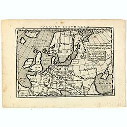
Germania ex descriptione Caesaris Plinij Taciti.
Map of ancient Europe, prepared by Petrus Bertius (1565-1629). From "Commentariorum Rerum Germanicarum Libri Tres : Primus est Germaniae veteris. Secundus, Germaniae...
Place & Date: Amsterdam, J.Janssonius, 1616
Selling price: $61
Sold in 2015
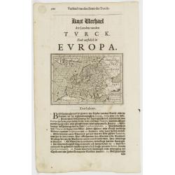
Europa.
Small map of Europe, surrounded by text in Dutch.Nicolaes de Clerck (de Klerc) was active as engraver and publisher in Delft from 1599-1621.Included in the rare book : We...
Place & Date: Amsterdam, Cloppenburch, 1621
Selling price: $90
Sold
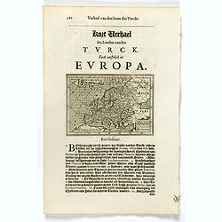
Europa.
Small map of Europe, surrounded by text in Dutch.Nicolaes de Clerck (de Klerc) was active as engraver and publisher in Delft from 1599-1621.Included in the rare book : We...
Place & Date: Amsterdam, Cloppenburch, 1621
Selling price: $90
Sold in 2019
Lumen Historiarum per Occidentem.
The map shows the western part of the Mediterranean (west of Crete) and Europe up to 54 degrees of latitude. From: Theatri Orbis Terrarum Parergon. Antwerpen. Balthasar M...
Place & Date: Antwerp, 1624
Selling price: $650
Sold in 2009
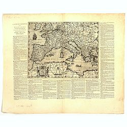
Lumen Historiarum Per Occidentem ex Conatibus Fran. Haraei Antverpia.'
Showing Europe.Cartographical sources: Frans van Haren [more commonly called Haraeus] who was born circa 1555 and died in 1631. He flourished between about 1615 and 1624,...
Place & Date: Antwerp, 1624
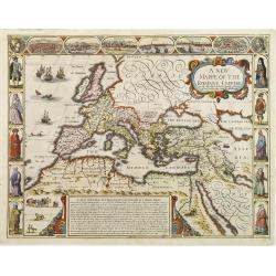
A new mappe of the Romane Empire newly described by I:Speede..
The map has six bird's-eye views of cities (Rome, Genoa, Jerusalem, Venice, Constantinople & Alexandria), and ten costume vignettes. In the sea off Ireland is a sea-b...
Place & Date: London 1626
Selling price: $1500
Sold