Browse Listings in Europe > British Isles
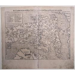
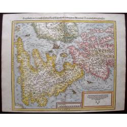
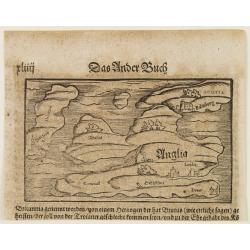
Das Engellandt/ mit dem anstossenden Reich Schottland/ so vorzeiten Albion und Britannia/ haben geheissen.
A woodcut map; on laid paper. This map is from the last German edition of the well-published 'Cosmographia', with Scotland orientated to the West. The map is decorated wi...
Place & Date: Basle, 1578
Selling price: $250
Sold in 2016
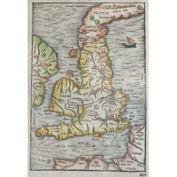
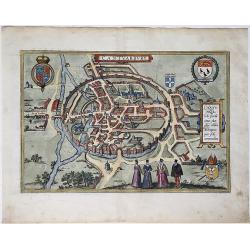
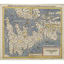
Beschreibung Engellands und Schottlandts
A very early and attractively coloured map of the UK, Engeland, Schotland, Ireland, and Wales, on a full leaf. A wonderful woodcut with picturesquely cut cities, seas and...
Place & Date: Basel, 1578
Selling price: $170
Sold in 2021
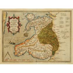
Cambriae Typus..
Ancient map of Wales, prepared by Humphrey Lhuyd. With fine cartouche, ship and a sea monster.
Place & Date: Antwerp 1579
Selling price: $390
Sold
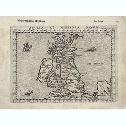
Anglia et Hibernia Nova. . .
One of the earliest maps of Great Britain.Girolamo Ruscelli's edition of Ptolemy's Geographia included newly engraved copperplates by Giulio and Livio Sanuti. From the se...
Place & Date: Venice, 1579
Selling price: $200
Sold in 2013
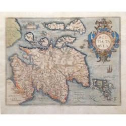
Scotiae Tabula.
From the Theatrum Orbis Terrarum, 1579. A fine map of Scotland with north to the right of the page. Ortelius derived this map from Mercator's 1564 map of the British Isle...
Place & Date: Antwerp, 1579
Selling price: $650
Sold in 2018
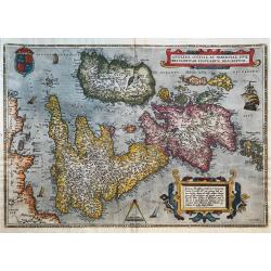
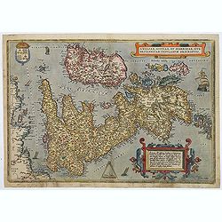
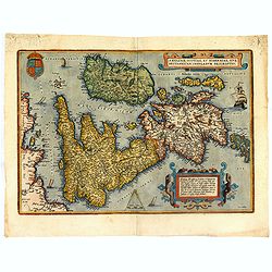
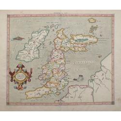
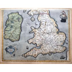
Anglia, Scotiae et Hiberniae, Sive Brittannicar: Insularum Descriptio
A classic and famous map of the British Isles with North to the right.Probably the earliest map of the British Isles that are still available. Despite the fact, that the ...
Place & Date: Antwerp, 1579
Selling price: $750
Sold in 2019
![[Edinburgh]](/uploads/cache/26202-250x250.jpg)
[Edinburgh]
Early panoramic view of Edinburgh. From his Cosmographia, that great compendium of Renaissance knowledge. An exciting print.Sebastian Münster was born in Nierder-Ingelhe...
Place & Date: Basle, 1550-1580
Selling price: $50
Sold in 2009
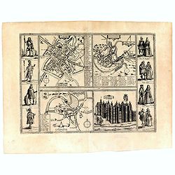
Yorke/ Shrowesbury/ Lancester/ Richmont.
Four views bring city plans of York, Shrewsbury and Lancashire and a view of the castle of Richmond. On each side of the four views are four figures in historical dress: ...
Place & Date: Cologne, 1580
Selling price: $300
Sold in 2016
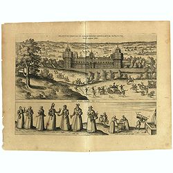
Palatium Regium in Angliæ Regno Appelatum Nonciutz. . .
This engraving is a view of Nonsuch Palace, with carriages and deer hunting, a panel of female costume figures below. Latin text verso, dated in the plate 1582. The scene...
Place & Date: Cologne, 1580
Selling price: $70
Sold in 2019
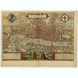
Londinum Feracissimi Angliae Regni Metropolis.
A very desirable and early plan of London, shown from the Tower to Westminster, with the City already built-up and a ribbon development westwards along the Strand. On the...
Place & Date: Cologne, 1580
Selling price: $5000
Sold in 2021
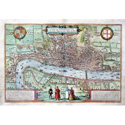
Londinum Feracissimi Angliae Regni Metropolis.
Important, early bird's-eye view of London, which appeared in the first Volume of Civitates Orbis Terrarum by Braun & Hogenberg.The view is based on a previous 15-she...
Place & Date: Cologne, ca 1580
Selling price: $4190
Sold in 2019
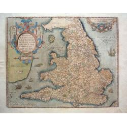
Angliae Regni flo: rentissimi nova descriptio, auctore Humfredo Lhuyd.
From the Theatrum Orbis Terrarum - French Text - this is Humphrey Lloyd's depiction of England and Wales published in the first Additamentum to the Ortelius atlas. The m...
Place & Date: Antwerp, 1581
Selling price: $600
Sold in 2013
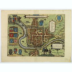
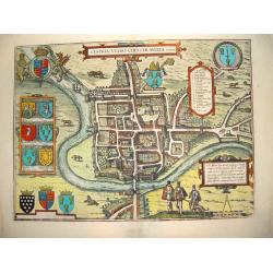
Cestria vulgo Chester, Angliae Civitas.
A stunning town plan of the northern city of Chester, with heraldic shields, Royal and civic coats of arms, explanation table, dividers and Elizabethan figures in the for...
Place & Date: Cologne, ca 1582
Selling price: $235
Sold in 2018
Angliae, scotiae, et Hiberniae, sive Britannicar insularum.
A state 3 of this classic, handsome and decorative map of ancient British Isles with north orientated to the east. Latin text on verso.Based on Mercator's 1564 map of the...
Place & Date: Antwerp, after 1584
Selling price: $550
Sold in 2018
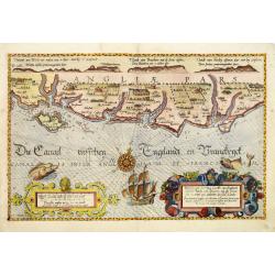
De Zee Custen tuschen Dovere eñ Orfordts nesse, daer de Teemse de Vermaerde Riviere vã Lõnen gelegens is, met alle sanden ondiepte, naer haren wesen eñ ghedaente / Orae maritimae inter Doverium et Ortfortnissam &tc.
Lucas Janszoon Waghenaer (1533/4-1606) published in 1583 his famous pilot-guide ' Spieghel der Zeevaerdt', the first printed pilot-guide with charts, in 1592 he published...
Place & Date: Leiden, 1585
Selling price: $1850
Sold in 2008
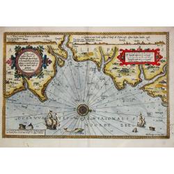
Zee caerte van Engelants Eijndt, Alsoe hem tselfde Landt verthoont beginnende van Sorlinges tot Pleijmondt . . .
A detailed chart of the sea coast of England, from the Sorlinges islands to the Plymouth region along the English Channel decorated by a very colorful title cartouche and...
Place & Date: Leiden, Plantijn, 1585
Selling price: $2200
Sold in 2009
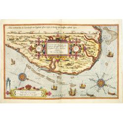
Befchrijvinghe der Zee, custen van Engelandt, tusschen Pleijmouth en Porthlandt. . .
A detailed chart of the sea coast of England, from Plymouth region along the English Channel to Portland decorated by a very colorful title cartouche and scale cartouche,...
Place & Date: Leiden, Plantijn, 1585
Selling price: $2400
Sold in 2009
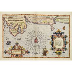
Befchrijvinghe der Zeecusten van Engelandt tusschen Wicht ende Doveren. . .
A detailed chart of the English channel coastland, from the island of Wight to Dover. Decorated by a very colorful title cartouche and scale cartouche, one compass rose, ...
Place & Date: Leiden, Plantijn, 1585
Selling price: $3400
Sold in 2008
Zee Caerte vande Noordt custe van Engelandt, alsoe tzelffde landt aldaer. . .
A detailed chart of the northern coast of England. Decorated by a colorful title cartouche and scale cartouche, one compass rose, several vessels. A very early edition ra...
Place & Date: Leiden, Plantijn, 1585
Selling price: $2600
Sold in 2008
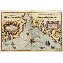
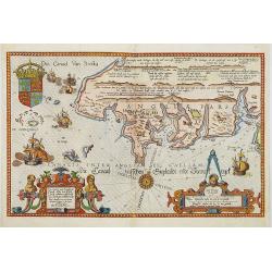
Beschrijvinge van een deel vann Schottlandt van Bambourg tot Aberdein. . .
A detailed chart of the coast of Scotland with Aberdeen. Decorated by a colorful title cartouche and scale cartouche, one compass rose, several vessels and sea monsters. ...
Place & Date: Leiden, Plantijn, 1585
Selling price: $3000
Sold in 2008
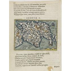
Scotia 7.
A page of printed text in Latin with a fine general map of Scotland. Prepared by Hugo Favolius (1523-1585), who was a Dutch poet, doctor and traveler, born in Middelburg....
Place & Date: Antwerp, Plantin, 1585
Selling price: $50
Sold in 2009
Zee Caerte vande Noordt custe van Engelandt, alsoe tzelffde landt aldaer. . .
A detailed description of the northern coast of England. Decorated by a title cartouche and scale cartouche, one compass rose, several vessels. A very early edition rare ...
Place & Date: Leiden, Plantijn, 1585
Selling price: $1000
Sold in 2016
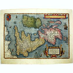
Eryn - Hiberniae, Britannicae Insulae, Nova Descriptio - Irelandt
A beautiful map of Ireland from Ortelius' "Theatrum Orbis Terrarum" or Atlas of the whole world. This is one of the earliest maps of Ireland to present it with ...
Place & Date: Antwerp, 1587
Selling price: $1300
Sold in 2011
Scotia Regnum.
Printed in Duisberg 1587.
Place & Date: Duisberg, 1587
Selling price: $600
Sold in 2014
Angliae, scotiae, et Hiberniae, sive Britannicar insularum.
A classic, handsome and decorative map of ancient British Isles with north orientated to the east. Based on Mercator's 1564 map of the British isles and improved by Saxto...
Place & Date: Antwerp, 1587
Selling price: $600
Sold in 2014
Angliae, scotiae, et Hiberniae, sive Britannicar : insularum descriptio.
A classic, handsome and decorative map of ancient British Isles with north orientated to the east. Based on Mercator's 1564 map of the British isles and improved by Saxto...
Place & Date: Antwerp, 1587
Selling price: $700
Sold in 2017
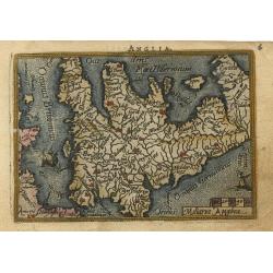
Anglia
Miniature map covering England and Wales. French text on verso. This map is oriented with north to the right. The map is beautifully engraved with stippled seas and ships...
Place & Date: Antwerp, 1588
Selling price: $150
Sold
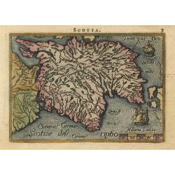
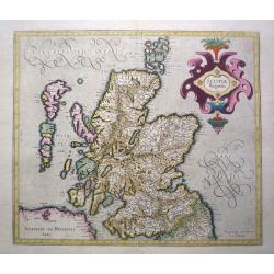
Scotia
Miniature map covering the northern part of England and Scotland. French text on verso. This map is oriented with north to the right. The map is beautifully engraved with...
Place & Date: Antwerp, 1588
Selling price: $220
Sold
Cestria Vulgo Chester, Angliae Civitas
This desirable, highly decorative depiction presents the city of Chester on the banks of the River Dea. Based on the survey of William Smith, the bird's-eye plan shows th...
Place & Date: Cologne, ca. 1588
Selling price: $850
Sold in 2008
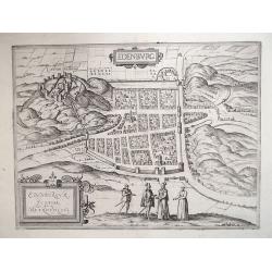
EDENBURG / EDENBURGUM, SCOTIAE METROPOLIS 1588
From an engraving in Ralph Holished’s Chronicles [1574], the Scottish Capital of Edinburgh during the reign of Mary Queen of Scots. Viewed from the South, it includes t...
Place & Date: Cologne, 1588
Selling price: $900
Sold in 2012
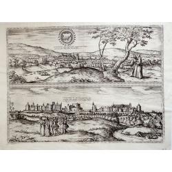
Oxonium nobile Anglie oppidum...; Vindesorium celeberrimum Anglie castrum... 1588
Decorative pair view of Oxford and view of Windsor Castle, from Braun & Hogenberg's "Civitatus Orbis Theatrum", the most famous atlas of city views publishe...
Place & Date: Cologne, 1588
Selling price: $650
Sold in 2012
Engellandt / mit dem anstossenden Reich Schottlandt / so vor zeiten Albion und Britannia haben geheissen.
Early map of England and the British Isles. The map is oriented with west at the top and provides a fine early depiction of the British Isles, based upon Ortelius' map of...
Place & Date: Basle, S.H. Petrie, 1588
Selling price: $120
Sold in 2014
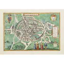
Cantuarbury.
A detailed city map in a 'bird's-eye view' of Canterbury, in original hand coloring, with the cathedral. Title at top centre, with left the crowned coat of arms of Englan...
Place & Date: Cologne, 1588
Selling price: $475
Sold in 2020
Anglia.
Map of Great Britain.From a German text edition of his Cosmographia , that great compendium of Renaissance knowledge.
Place & Date: Basle 1550-1590
Selling price: $40
Sold
Cantuarbury.
A spectacular and early view of Canterbury.From the greatest publication in this genre! The Civitates was compiled and written by George Braun, Canon of Cologne Cathedral...
Place & Date: Cologne 1590
Selling price: $550
Sold
Engellandt mit dem anstossenden Reich Schottlandt so vor zeiten Albion und Britannia haben geheissen.
A decorative map of Great Britain and eastern part of Ireland. Oriented to the west. Tablet in lower right corner with a brief commentary in German. Two ships and a sea-c...
Place & Date: Basle, 1590
Selling price: $220
Sold in 2010
Tab. I. Europae Continens Albion, Britanniam, et Hiberniam.
Mercator’s map of Great Britain, based on Ptolemy’s Geographia. This map is from the 1584 edition of his Tabulae Geographicae. The ancient map of the British Isles ha...
Place & Date: Cologne, Amsterdam, 1590
Selling price: $500
Sold in 2012
![[British Isles ]](/uploads/cache/32517-250x250.jpg)
[British Isles ]
On recto an early birds-eye view of Great Britain. Cornwall is depicted as an entity on an equal footing as Wales and Scotland.From a Latin text edition of his Geographia...
Place & Date: Basle, 1550-1590
Selling price: $30
Sold in 2013
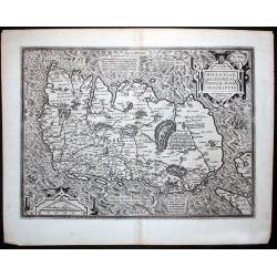
Brittanicarum Insularum Vetus Descriptio.
Southern part of Ortelius important two-sheet map of the British Isles. Includes Ireland, Wales, the Isle of Man, and England. Shows the Hadrian's Wall. Richly decorated ...
Place & Date: Antwerp, c1590
Selling price: $550
Sold in 2013
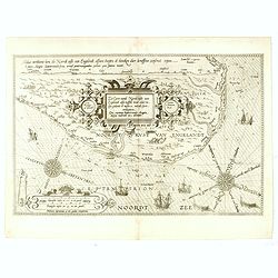
![[Showing the 1588 defeat of the Spanish Armada in the English Channel]](/uploads/cache/20220907_173700-250x250.jpg)
[Showing the 1588 defeat of the Spanish Armada in the English Channel]
Beautiful engraving by Michael Eytzinger, showing the 1588 defeat of the Spanish Armada in the English Channel. Latin text on verso. Published in Leonis Belgici Descript...
Place & Date: Cologne, ca. 1590
Selling price: $200
Sold in 2022