Browse Listings in Europe > British Isles
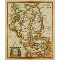
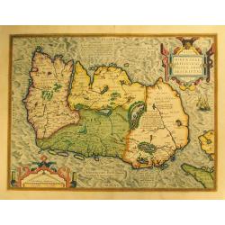
Udrone Irlandiae in Catherlagh Baronia.
Depicts present day County Carlow in Leinster Province & Catherlaugh which is now Carlow. The title is surrounded by a strap work design cartouche topped with caliper...
Place & Date: Amsterdam 1639-44.
Selling price: $160
Sold
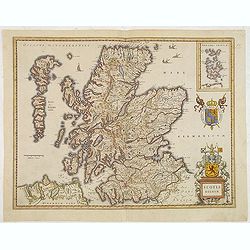
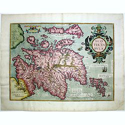
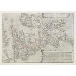
Scotia Regnum.
A attractive example of this fine map of Scotland.
Place & Date: Amsterdam, ca.165
Selling price: $260
Sold in 2013
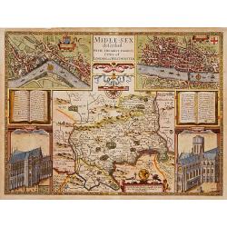
Middle-Sex described with the most famous cities of London and Westminster.
One of the most famous and sought-after of Speed's County maps. The County of Middlesex surrounded by a splendid border incorporating a plan of Westminster and London. In...
Place & Date: London 1610-23
Selling price: $1950
Sold
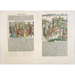
Anglie Provincia (Tercia estas mundi Foliu XLVI ) / Salomon's genealogy tree (XLVI) / Genealogy tree & Abner & Joab (XLVII) / Judgment of Solomon (XLVII).
Woodcuts depicting an imaginary England countryside, showing a fortified city above a fast-flowing river. According to Rodney Shirley "[the two woodcuts] are masterf...
Place & Date: Nuremberg, 12 July 1493
Selling price: $800
Sold in 2020
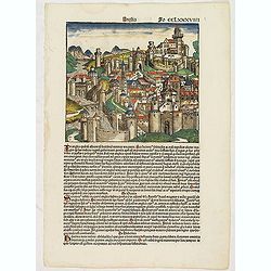
Anglia Fo CCLXXXVIIII (Town in England)
Text page in latin on recto a hill-side city in England with a series of gates leading up to a citadel. It is one of two woodcuts used for England in the work. On the rer...
Place & Date: Nuremberg, 12 July 1493
Selling price: $500
Sold in 2017
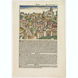
Anglia / Hispania. Fo CCLXXXVIIII.
Text page in Latin on recto a hill-side city in England with a series of gates leading up to a citadel. It is one of two woodcuts used for England in the work. On the ver...
Place & Date: Nuremberg, 12 July 1493
Selling price: $325
Sold in 2017
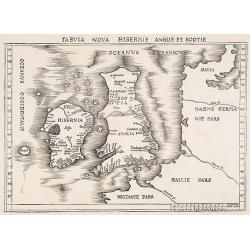
Tabula nova Hibernie Anglie et Scotie.
Martin Waldseemuller's issue of "Geographia," published in 1513 and 1520, was one of the most important atlases of the first half of the sixteenth century as th...
Place & Date: Strasbourg, 1513-1520
Selling price: $4000
Sold in 2009
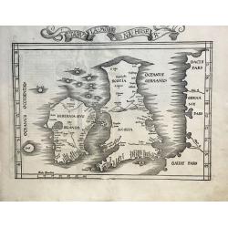
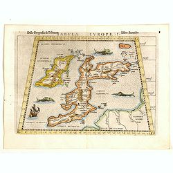
TAB I EURO PRINCIPIUM EUROPAE....TABULA I EUROPAE
Martin Waldseemuller's edition of the classical cartography of Claudius Ptolemy that had first appeared in 1513.The British Isles, set in a trapezoid frame this woodblock...
Place & Date: Stassburg, 1522
Selling price: $2500
Sold in 2012
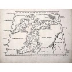
Tabula Moderna Hiber.
One of the Earliest obtainable Modern Maps of the British Isles. A nice example of the 1525 edition of Lorenz Fries's double-page woodblock modern map of the British Isl...
Place & Date: Strasbourg, 1525
Selling price: $1300
Sold in 2021
![[Map of the British Isles]](/uploads/cache/40500-250x250.jpg)
[Map of the British Isles]
First edition Inghilterra.Rare: A very early woodblock map of the British Isles by the Italian cartographer Benedetto Bordone, an 16th century illuminator and wood engrav...
Place & Date: Venice, 1528
Selling price: $650
Sold in 2017
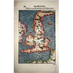
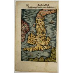
Das Kunigreich Engelland, mit dem anstossenden Reich Schottland, so vor zeiten Albion und Britannia, haben geheissen.
An early, unusual woodcut map of the British Isles, which is oriented to the East. Sebastian Munster's map was the first separately printed map of England and a landmark ...
Place & Date: Basel, ca 1540
Selling price: $375
Sold in 2019
![[Great Britain, Ireland]](/uploads/cache/33865-250x250.jpg)
[Great Britain, Ireland]
Wood block printed map and one of earliest printed representation of the Great Britain and Ireland prepared Martin Waldseemüller. Based on the slightly larger map from 1...
Place & Date: Vienna, Trechsel, G., 1525 -1541
Selling price: $750
Sold in 2013
![[Map of the England]](/uploads/cache/31504-250x250.jpg)
[Map of the England]
Page with an early representation of the British Isles. This text page with a fine wood block printed map is from the rare work "C. Iulii Solini Polyhistor, Rerum To...
Place & Date: Basle, Michael Isengrin, 1544
Selling price: $475
Sold in 2011
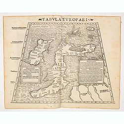
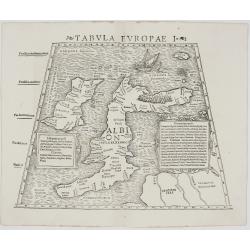
Tabula Europae I (Great Brittain)
The first edition of Munster's Ptolemaic map of Great Britain appeared in his "Geographia Universalis", first published in 1540. This was a new and important ed...
Place & Date: Basel, Heinrich Petri, 1545
Selling price: $540
Sold in 2014
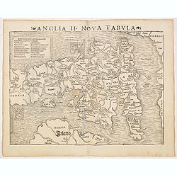
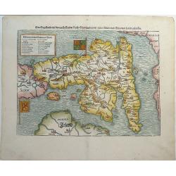
Anglia II Nova Tabula (British Isles)
The first edition of Munster's first printed separate map of England and Wales, with Scotland as far north as Edinburgh, the east coast of Ireland and north coast of Fran...
Place & Date: Basel, Heinrich Petri, 1545
Selling price: $475
Sold in 2014
Tabula Europae I (Great Britain).
Nice example of the rare third state of Ruscelli's map of the British Isles, based Claudius Ptolemy.The map first appeared in the 1561 edition of Ruscelli's edition of Pt...
Place & Date: Basel, Heinrich Petri, 1545
Selling price: $170
Sold in 2017
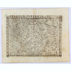
Anglia e Hibernia Nova
Gastaldi's modern map of the British Isles. It is one of the earliest obtainable modern maps of the British Isles.From Giacomo Gastaldi's Atlas of 1548 which has been cal...
Place & Date: Venice, 1548
Selling price: $600
Sold in 2021
Tabula Europae I. (British Isles)
Gastaldi's map of the British Isles based upon Ptolemy.It is one of the earliest obtainable maps of the region .From Giacomo Gastaldi's Atlas of 1548 which has been calle...
Place & Date: Venice, 1548
Selling price: $450
Sold in 2021
Das Engelland, mit dem anstossenden Reich Schottland. . . Britannia. . .
An antique map of England and Wales, with parts of Scottland and Ireland. Full title : Engellandt/ mit dem anstossenden Reich Schottlandt/ so vor zeiten Albion und Britan...
Place & Date: Basel ca 1550
Selling price: $325
Sold in 2020
Beschreibung Engellandts und Schottlandts.
A full-page woodcut map of England, Scotland, Wales, and part of Ireland, published in Basel, circa 1550. This charming woodblock map of Britain is the base for the Merca...
Place & Date: Basel, ca 1550
Selling price: $200
Sold in 2021
Tabula Europae I
Very rare issue and the first Munster’s map of the British Isles, based on Ptolemy’s writings. Woodcut map of the British Isles and the northern European coast by Seb...
Place & Date: Basel, 1552
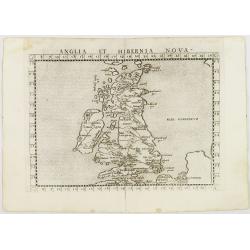
Anglia et Hibernia Nova. . .
Uncommon first edition of one of the earliest maps of Great Britain.Girolamo Ruscelli's edition of Ptolemy's Geographia included newly engraved copperplates by Giulio and...
Place & Date: Venice, 1561
Selling price: $410
Sold in 2008
Britania Insula quae dup Regna continet Angliam et Scotiam cum Hibernia adiacente. Ferando Berteli exc. 1561. Venise: 1562
One of the earliest printed maps of England. The essential roots of mid-16th century mapping of the British Isles go back to the English catholic priest George Lily (ca 1...
Place & Date: Venice, 1564
Selling price: $16800
Sold
Britannischen Insula.
An unusual outline of the British Isles, influenced by Ptolemy.
Place & Date: Basle, 1570
Selling price: $300
Sold in 2016
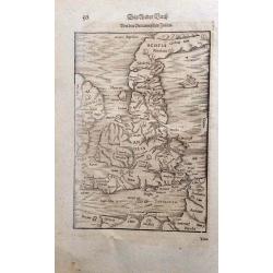
Tabula Britanniae. (British Isles)
Double-page woodcut Ptolemaic-style map by Sebastian Münster figuring the British Isles, published in the edition of Strabo by Henri Petri in 1571."Strabonis rerum ...
Place & Date: Basle, Henri Petri, 1571
Selling price: $401
Sold in 2018
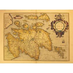
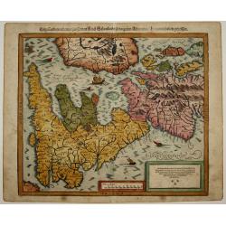
Scotiae Tabula.
Original old colored map of Scotland by A. Ortelius with north to the right of the plate. With one large cartouche, one sailing ship and a sea monster. From the 1573 Dutc...
Place & Date: Antwerp, 1573
Selling price: $550
Sold in 2012
Angliae Regni flo: rentissimi nova descriptio, auctore Humfredo Lhuyd.
Stunning map of England and Wales compiled from Mercator's 1564 wall map of the British Isles and Lhuyd's manuscript map of 1568. The countryside is fully engraved with t...
Place & Date: Antwerp, 1573
Selling price: $570
Sold in 2017
Anglia et Hibernia Nova. . .
One of the earliest maps of Great Britain.Girolamo Ruscelli's edition of Ptolemy's Geographia included newly engraved copperplates by Giulio and Livio Sanuti. From the se...
Place & Date: Venice, 1574
Selling price: $150
Sold in 2009
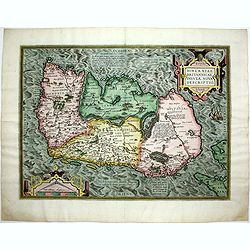
Eryn - Hiberniae, Britannicae Insulae, Nova Descriptio - Irelandt.
A beautiful map of Ireland from Ortelius' "Theatrum Orbis Terrarum." This map is significant as the first separate printed map of Ireland. It’s also one of th...
Place & Date: Antwerp, 1574
Selling price: $900
Sold in 2012
Hiberniae Britannicae insulae nova descriptio.
Copied from Mercator's influential wall map of the British Isles of 1564, this is certainly the best map of Ireland of the 16th century.
Place & Date: Antwerp, 1574
Selling price: $870
Sold in 2015
Scotiae tabula.
Very fine general map of Scotland with north to right of page. Derived from Mercator's 1564 map of the British Isles in 8 sheets.
Place & Date: Antwerp, 1574
Selling price: $650
Sold in 2016
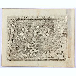
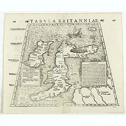
![Tabula Europae I [British Isles].](/uploads/cache/42111-250x250.jpg)
Tabula Europae I [British Isles].
An early double page Ptolemaic map of the British Isles from 'La Geografia Di Claudio Tolomeo Alessandrino...' published by G. Ziletti, Venice (using plates from the 1561...
Place & Date: Venice, 1574
Selling price: $210
Sold in 2019
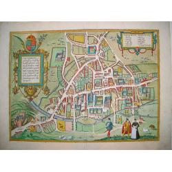
Cantebrigia...
A sought after and highly decorative early bird's-eye plan of the ancient university town of Cambridge. From Braun & Hogenberg's monumental work, CIVITATES ORBIS TERR...
Place & Date: Cologne, ca. 1575
Selling price: $1050
Sold in 2008
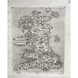
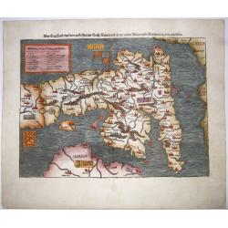
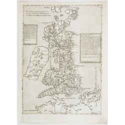
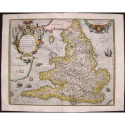
INGILTERRA ET SCOTIA.
One of the earliest modern Maps of England, Wales & Scotland. A very rare early map of England, Wales and Scotland, with topography and main settlements, depicted pic...
Place & Date: Venice, 1570-1575
Selling price: $1750
Sold in 2022
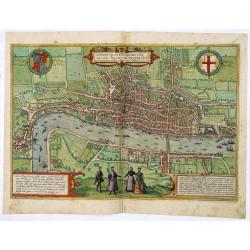
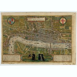
Londinium Feracissmi Angliae Regni Metropolis.
Very desirable and early plan of London - in a second state - shown from the Tower to Westminster, with the City already built-up and a ribbon development westwards along...
Place & Date: Cologne, (1572) 1577
Selling price: $5400
Sold in 2013
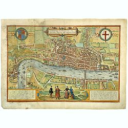
Londinum Feracissimi Angliae Regni Metropolis.
Very desirable and early plan of London - in a second state - shown from the Tower to Westminster, with the City already built-up and a ribbon development westwards along...
Place & Date: Cologne, (1572) 1577
Selling price: $4900
Sold in 2018
Londinum Feracissimi Angliae Regni Metropolis.
Very desirable and early plan of London - in a second state - shown from the Tower to Westminster, with the City already built-up and a ribbon development westwards along...
Place & Date: Cologne, (1572) 1577
Angliae Scotiae et Hibernie nova descriptio.
FIRST EDITION of this fine example of De Jode's rare map of the British Isles, oriented with West at the top. The map was based on Mercator's wall map from 1554. From the...
Place & Date: Antwerp 1578
Selling price: $2650
Sold
Engellandt/ mit dem anstossenden Reich Schottlandt/ so vorzeiten Albion und Britannia haben geheissen.
From 'Cosmographia, das ist: Beschreibung der Gantzen Welt,...'; German edition. wood engravings set into text; overall size 33 x 20 cm. on verso: engraved title. Münst...
Place & Date: Basle, c. 1578
Selling price: $400
Sold in 2015
Beschreibung Engellandts und Schottlandts.
From 'Cosmographia, das ist: Beschreibung der Gantzen Welt,...'; published in Basle, c1578, German edition.wood engraving set into text; overall size 33 x 20 cm. On verso...
Place & Date: Basle, c. 1578
Selling price: $210
Sold in 2015