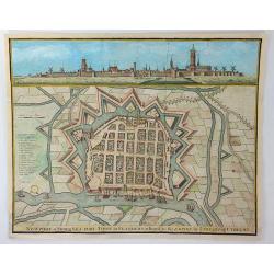
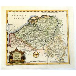
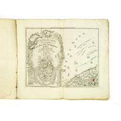
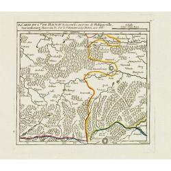
Newport a Strong Sea-Port Town in Flanders, Restored to the Empire by the Treaty of Utrecht.
A hand colored plan of Newport, a sea port town of Flanders from Tindal's Continuation of Mr. Rapin's "HISTORY OF ENGLAND". Engraved by James Basire in London c...
Place & Date: London, ca. 1750
Selling price: $35
Sold in 2016
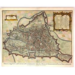
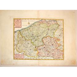
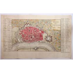
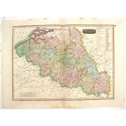
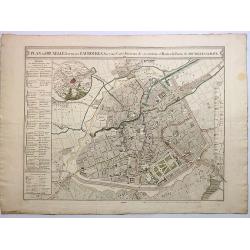
Ghent, a Large City and Castle in Flanders
A very fine bird's-eye plan of the city and fortifications of Ghent and the surrounding countryside in Belgium. A decorative cartouche encloses a detailed key to the map ...
Place & Date: London, 1750
Selling price: $150
Sold in 2016
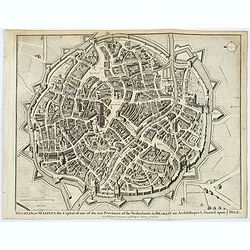
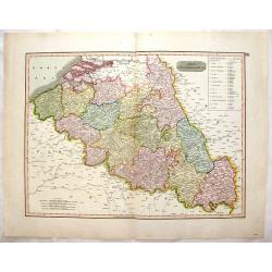
Mechlin, or Malines the Capital of one of the ten Provinces of the Netherlands. . .
A detailed 'bird's eye view of the Belgian city of Mechelen. Streets are named, and houses and buildings are shown in great detail. Prominent buildings shown. City walls ...
Place & Date: London, ca 1750
Selling price: $50
Sold in 2020
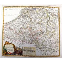
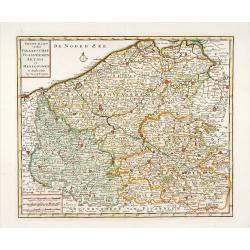
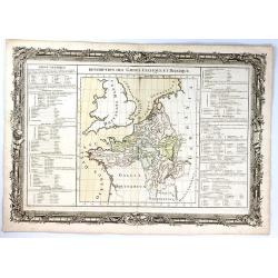
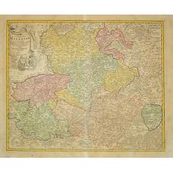
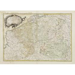
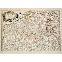
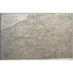
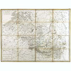
Pays-Bas Catholiques.
Nice, detailed, copper engraved map of the region of present day Belgium and Luxembourg. A fine military themed cartouche with a large fancy cartouche. Gilles Robert de V...
Place & Date: Paris, 1751
Selling price: $46
Sold in 2015
Pays-Bas Catholiques . . .
Detailled map of Belgium from his "Atlas Universel".Gilles Robert de Vaugondy (1688–1766), also known as Le Sieur or Monsieur Robert, and his son, Didier Robe...
Place & Date: Paris, 1751
Selling price: $45
Sold in 2011
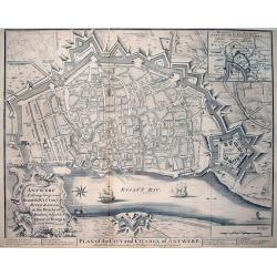
Antwerp A strong, large, and Beautiful City on ye River Scheld, in the Dutchy of Brabant, subject to ye Queen of Hungary / Plan of the City and Citadel of Antwerp
A large and very detailed plan of Antwerp with its forts. Shows numerous buildings and street names! Published in "Mr Tindal's Continuation of Mr Rapin's History of ...
Place & Date: London, 1751
Selling price: $99
Sold in 2013
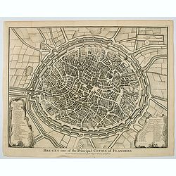
Bruges one of the Principal Cities of Flanders.
A birds-eye plan of the lovely Belgian city of Bruges, seen here within its ancient walls and fortifications. A number of bridges and windmills are shown, along with pict...
Place & Date: London, ca 1751
Selling price: $55
Sold in 2019
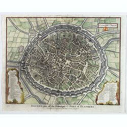
Bruges one of the Principal Cities of Flanders.
A birds-eye plan of the lovely Belgian city of Bruges, seen here within its ancient walls and fortifications. A number of bridges and windmills are shown, along with pict...
Place & Date: London, ca 1751
Selling price: $150
Sold in 2023
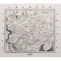
Partie Meridion. du Duche de Brabant. . .
Detailled map of a part of Belgique from his "Atlas Universel".Gilles Robert de Vaugondy (1688–1766), also known as Le Sieur or Monsieur Robert, and his son, ...
Place & Date: Paris, 1752
Selling price: $20
Sold in 2013
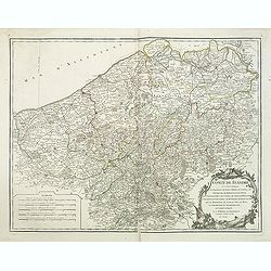
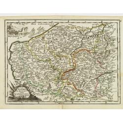
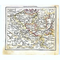
Comté de Flandre. . .
Detailled map of Flanders from his "Atlas Universel", with the privilege.Gilles Robert de Vaugondy (1688–1766), also known as Le Sieur or Monsieur Robert, and...
Place & Date: Paris, 1752
Selling price: $46
Sold in 2011
Partie Meridion. du Duche de Brabant.
Detailed map of a part of Belgium from his "Atlas Universel".Gilles Robert de Vaugondy (1688–1766), also known as Le Sieur or Monsieur Robert, and his son, Di...
Place & Date: Paris, 1752
Selling price: $75
Sold in 2014
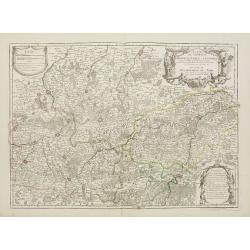
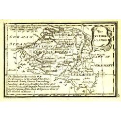
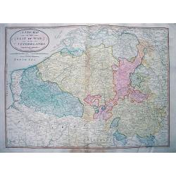
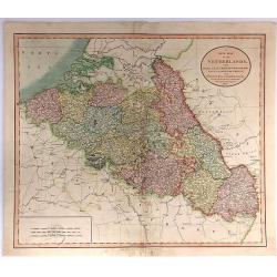
A New & Accurate Map of the Netherlands or Low Countries.
Fine copper-engraved map with good detail of roads, towns, and canals. Also shown are the Barrier Towns as designated by the Barrier Treaty, concluded at Antwerp in 1715...
Place & Date: London, 1752
Selling price: $95
Sold in 2018
Nieuwe kaart van het Graafschap Vlaanderen, Artois. . .
Detailed map of western part of present day Belgium. Published by Isaäk Tirion in deLuxe edition of "Handatlas der geheele Aarde", Amsterdam, 1753.
Place & Date: Amsterdam, 1753
Selling price: $65
Sold in 2020
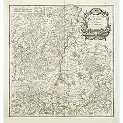
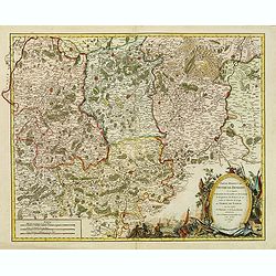
La principaute de Liege et le duche de Limbourg.
Detailled map of Belgium around Liege from his "Atlas Universel".Gilles Robert de Vaugondy (1688–1766), also known as Le Sieur or Monsieur Robert, and his son...
Place & Date: Paris, 1754
Selling price: $50
Sold in 2013
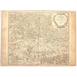
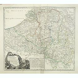
Comtes de Hainaut et de Cambresis.
Large copperplate map of parts of Belgium and France including the counties of Hainaut, Cambrai, Flanders, Brabant and Namur. It was published by Robert de Vaugondy.
Place & Date: Paris, 1754
Selling price: $15
Sold in 2016
La Flandre Le Haynaut.
Fine map of the Flanders and the province of Hainaut. It presents a decorative title cartouche and a decorative cartouche on upper left corner. George Louis Le Rouge was ...
Place & Date: Paris 1756
Selling price: $30
Sold
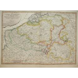
Austrian and French Netherlands.
Interesting copper engraved map featuring the Flanders and Brabant regions bordered by Luxemburg and Artois. Featuring a decorative Rococo title cartouche and a prominent...
Place & Date: London, 1758
Selling price: $25
Sold in 2013
Description des Gaules Celtique et Belgique
A fine map of Gallic France and Belgium by Claude Buy de Mornas. It is from “Atlas Méthodique et Elémentaire de Géographie et l’ Histoire”, published in 1761.The...
Place & Date: Paris, 1761
Selling price: $35
Sold in 2017
Nuova Carta delle Contee di Fiandra, Artois ed Hannonia.
Detailed copper engraved map featuring the Flanders region of Belgium. Two block type cartouches. Published by Giambattista Albrizzi (1698-1777) who was a Venetian publis...
Place & Date: Venice from 1740-1762
Selling price: $16
Sold in 2016
Flanders and the low Countries.
Uncommon miniature map of Belgium, engraved by Thomas Kitching for "A New General and Universal Atlas Containing Forty-five Maps by Andrew Dury." This miniature...
Place & Date: London, 1761-1763
Selling price: $25
Sold in 2017
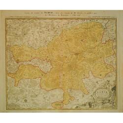
Carte de Namur.
Johann Baptist Homann (1663-1724). Outstanding German cartographer. Founder of the Homann publishing house. After the death of the son Johann Christoph, the firm continue...
Place & Date: Nürnberg, c. 1770
Selling price: $40
Sold in 2013
Commitatus Hannoniae.
Johan Baptist Homann (1663-1724). Outstanding German cartographer. Founder of the Homann publishing house. After the death of the son Johann Christoph, the firm continued...
Place & Date: Nürnberg, c. 1770
Selling price: $40
Sold in 2013
Sedes ac Theatrum Bellorum in Regionibus Rheni, Mosae ac Mosellae.
Striking, highly detailed copper engraved map of the Netherlands, Belgium and parts of Germany. Adorned with a large Rococo style double title and scale cartouche. The Lo...
Place & Date: Augsburg, 1774
Selling price: $27
Sold in 2016
BELGIUM.
Map of the southern part of Belgium and the northern part of France. Brussels in the north, Mons in the south, Huy in the east and Tournay/Douai in the west.
Place & Date: Paris 1781
Selling price: $35
Sold
Partie Méridionale des Pays Bas, Comprenant les Provinces de Brabant, Gueldre, Lumbourg, Luxembourg..
Attractive map centered on Belgium, encompassing Luxembourg, part of France and the southern part of the Netherlands.ornated with a decorative title cartouche. Boundaries...
Place & Date: Paris, ca 1783
Selling price: $100
Sold in 2008
Partie Meridionale Des Pays Bas.
A pleasing example of Jean Janvier's 1783 decorative map of the southern portions of the Pays Bas, or Belgium and Luxembourg. It covers modern day Belgium and Luxembourg,...
Place & Date: Paris, 1783
Selling price: $30
Sold in 2018
Partie Meridionale des Pays Bas Comprenant les provinces de brabant, Gueldre, Limbourg, Luxembourg, Haynaut, Namur, Flandre, Cambresis et Artois.
A map of Belgium and Luxembourg. Embellished with an attractive title-cartouche.
Place & Date: Paris, 1785
Selling price: $60
Sold in 2010
LIEGE,
Map of the princedom of Liege and part of the Dutch province Limburg, with the cities of Maastricht and Liege in the centerpart of the map. An inset map represents the e...
Place & Date: Paris 1785
Selling price: $70
Sold
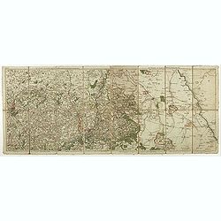
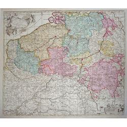
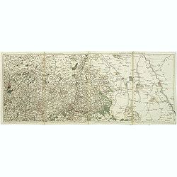
Nouvelle carte chorographique des Pays-Bas autrichiens.
COMPLETE Wall map of the Southern Low Countries (or Austrian Netherlands) published in 1789, composed of 16 leaves, each map ca. 320x395mm. and bound together.First map w...
Place & Date: Bruxelles, 1789
Selling price: $840
Sold
Les environs de Louvain..., Les environs de Limbourg, Rolduc,. . .
Showing the cities of Louvain, Liege, Aix la Chapelle, Cologne. . . The map was prepared by Jean Baptiste de Bouge (1757-1833), who prepared one of the first very detaile...
Place & Date: Bruxelles, 1789
Selling price: $25
Sold in 2017
Pays Bas françois et Autrichien..
Map of Belgium. With on verso a chart showing the coasts of the French Channel.Louis Capitaine (1749-1797) worked with Belleyme and Chanlaire on Topographical maps of Fra...
Place & Date: Paris ca.1790
Selling price: $20
Sold
Die Markgrafschaft des heiligen römischen Reichs Antwerpen mit der Herrschaft Mecheln.
A detailed large scale map of the area with Antwerp, Lier, Herentals, Geel, Mol, Turnhouta, Hoogstraten, etc. Shows many small towns.
Place & Date: Vienna, ca. 1790
Selling price: $30
Sold in 2018
Theatre de la Guerre dans les pays-bas, ou se trouvent...
War Map of present-day Belgium. The Robert de Vaugondy family of mapmakers were preeminent in the eighteenth century, at a time when the French were at the forefront of c...
Place & Date: Paris, 1792
Selling price: $87
Sold in 2010
The Netherlands.
Uncommon miniature map from Gibson's "Atlas Minimus, or a New Set of Pocket Maps of the several Empires, Kingdoms and States of the known World".
Place & Date: London, 1792
Selling price: $35
Sold
CARTE NOUVEUE DE PAIS BAS CATHOLIQUES
A detailed map showing Belgium and Luxembourg besides part of France. Probably printed from an old plate by De l'Isle with the imprint altered by Elwe.
Place & Date: Amsterdam, 1792
Selling price: $160
Sold in 2015
Les environs de Louvain, Tirlemont, . . . Les environs de Limbourg, Bolduc, . . .
Detailed map of Belgium. Showing the cities of Louvain, Liege, Diest, Maastricht and Aix la Chapelle, Cologne, etc. The map was prepared by Jean Baptiste de Bouge (1757-1...
Place & Date: Bruxelles, 1793
Selling price: $55
Sold in 2011
Les environs de Namur, Dinant,. . .Les environs de SPA, Stavelot, . . .
Detailed map of Belgium, showing the cities of Namur, Dinant, Spa, Stavelot. The map was prepared by Jean Baptiste de Bouge (1757-1833), who prepared one of the first ver...
Place & Date: Bruxelles, 1793
Selling price: $9
Sold in 2011
Nouvelle carte chorographique des Pays Bas Autrichiens dédiée aux amateurs des arts. . .
Map of Belgium and Zeeland in the Netherlands. On the left a beautiful title cartouche with putti.The map was prepared by Jean Baptiste de Bouge (1757-1833), who prepared...
Place & Date: Bruxelles, 1793
Selling price: $95
Sold in 2011
A New Map of the Seat of War in the Netherlands.
Large detailed map of Belgium, including parts of France, Luxembourg, Germany, and the Netherlands. Shows the status of the French Revolutionary Wars in 1794. Important m...
Place & Date: London, 1794
Selling price: $26
Sold in 2012
The Catholic Netherlands, or The Low Countries. Comprehending The Provinces of Brabant, Gelderland, Limburg, Luxemburg, Haynaut, Namur, Flanders, Cambre Sis & Artois by Samuel Dunn Mathematician.
A highly detailed map of the Netherlands by Samuel Dunn Published by R. Laurie & J. Whittle No 53 Fleet Street May 1794.
Place & Date: London, 1794
Selling price: $120
Sold in 2014
IX. Carte du C.té de Haynaut où sont les environs de Philippeville, Marienbourg, Rocroix &c.
Attractive small map showing an area straddling the border between France and Belgium. It shows Philippeville, Marienbourg, Rocroi, Couvin and Chimay.From Atlas Portatif ...
Place & Date: Paris, 1799
Selling price: $15
Sold in 2020
Plan de la Ville d'Anvers.
A beautiful antique hand colored map of Antwerp after the War of Spanish Succession (1701-1713), when Antwerp was transferred from Spanish control to the Austrian Habsbur...
Place & Date: Paris, ca. 1800
Selling price: $235
Sold in 2018
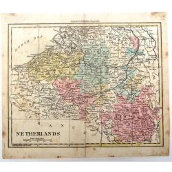
Netherlands.
Detailed map of the Netherlands by William Darton Jr. It is from Walker's Geography and is decorated with original coloring.
Place & Date: London, 1802
Selling price: $30
Sold in 2016
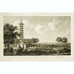
Vue de l'Orangerie dans le Parc J. & R(oya)l. prés de Brussels.
Copper engraving by Lorieux after a design of S. Le Febre. Showing the Orangerie at a parc near Brussels. Published by Tessari & Co.
Place & Date: Paris, Tessari, 1803
Selling price: $100
Sold in 2017

Ière Vue du Palais Impérial & Royal, près de Bruxelles.
Copper engraving by Lorieux after a design of S. Le Febre. Showing the Imparial Palace near Brussels. Published by Tessari & Co.
Place & Date: Paris, Tessari, 1803
Selling price: $80
Sold in 2017
A New Map of the Netherlands, Also Of that part of Germany Westward of the Rhine
A detailed map of John Cary’s Netherlands, from the important early 19th century “NEW UNIVERSAL ATLAS”. It covers from Dunkirk eastward as far as the German border....
Place & Date: London, 1804
Selling price: $25
Sold in 2017
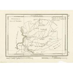
Département des 2 Nethes.
Map representing the area around Antwerp, with a short key list in the upper right corner.From Atlas de la Géographie de toutes les parties du monde .. Ouvrage destiné ...
Place & Date: Paris, Prudhomme, Levrault, Debray, 1806
Selling price: $20
Sold in 2017
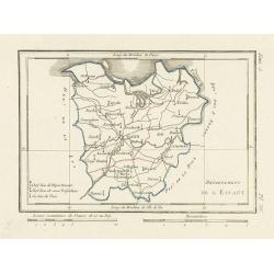
Département de l'Escaut.
Map centered on Gand, with a short key list in the lower left corner. From Atlas de la Géographie de toutes les parties du monde .. Ouvrage destiné pour l'education, et...
Place & Date: Paris, Prudhomme, Levrault, Debray, 1806
Selling price: $60
Sold
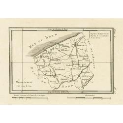
Département de la Lys.
Map representing the area between Furnes, Ypres, Courtray and Bruges, with a short key list in the upper right corner.From Atlas de la Géographie de toutes les parties d...
Place & Date: Paris, Prudhomme, Levrault, Debray, 1806
Selling price: $5
Sold in 2023
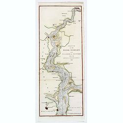
Sketch of the River Scheldt, from Flushing to Antwerp with the Soundings Fortifications, &c. 1810
A chart of a portion of the Scheldt River in Belgium. It is after the earlier work by the French hydrographer Beautemps Beaupre. Named places include: Antwerp, Fort Lillo...
Place & Date: London, 1810
Selling price: $65
Sold in 2019
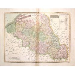
The Netherlands. (Belgium)
Striking, large map of Belgium here called The Netherlands divided into thirteen departments.John Thomson (1777-c1840) was a Scottish cartographer from Edinburgh, celebra...
Place & Date: Edinburgh, 1814
Selling price: $20
Sold in 2016
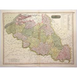
The Netherlands. (Belgium)
This striking hand colored 1814 Thomson map shows modern day Belgium, here called the Netherlands divided into thirteen departments. The labeled the Netherlands or “Low...
Place & Date: Edinburgh, 1814
Selling price: $9
Sold in 2016
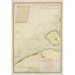
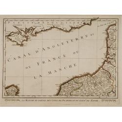
Carte réduite des côtes des Pays-Bas.
repaired by Beautemps-Beaupreé. Covering the coast from Oostende till Hellevoetssluis. Giving exquisite detail with soundings. Upper left large advertisement, upper rig...
Place & Date: Paris, 1817
Selling price: $350
Sold in 2013
The Netherlands.
Striking large hand-colored map of The Netherlands. From John Thomson's "New General Atlas",/b> published in 1817. Engraved by J. Moffat.
Place & Date: Edinburgh, 1817
Selling price: $44
Sold in 2018
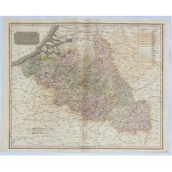
The Netherlands (Belgium and Luxemburg)
A fine map of Belgium and Luxembourg by John Thomson, the Edinburgh cartographer. The title ‘The Netherlands’ refers to the old name for Belgium. The map covers the r...
Place & Date: Edinbourgh, 1817
Selling price: $21
Sold in 2016
The Netherlands.
A pleasing hand colored 1817 map of Holland by Thomson, engraved in the minimalist English style of the early part of the 19th century. Relief is shown by hachure with to...
Place & Date: Edinbourgh, 1817
Selling price: $25
Sold in 2019
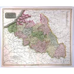
Belgium or the Netherlands.
A striking 1817 map of Belgium and Luxembourg by the Edinburgh cartographer John Thomson. The title ‘The Netherlands’ refers to the old name for Belgium covering the ...
Place & Date: Edinbourgh, 1817
Selling price: $49
Sold in 2018
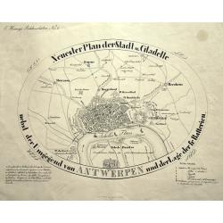
Neuester Plan der Stadt und Citadelle nebst der Umgegend von ANTWERPEN und der Lage der fr. Batterien.
Curious and apparently rare plan of Antwerp and surroundings, published in "Hennig's Bilderschätze". With two keys 1-15 and 1-6 identifying buildings and forti...
Place & Date: Prague, ca. 1828
Selling price: $93
Sold in 2015
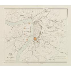
Plan de la Ville et des Environs d'Anvers.
Bird-eye view of Antwerp. Engraved by van Em. The positions occupied by the Dutch are marked in red.
Place & Date: Bruxelles 1832
Selling price: $30
Sold
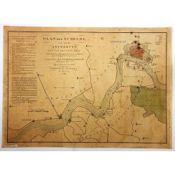
Plan der Schelde van Boven Antwerpen...
Plan of Schelde from Antwerp to the village of Doel: with the position of our ship force at the resumption of hostilities against the Belgians, on August 3, 1831.By F. Ka...
Place & Date: Amsterdam, 1832
Selling price: $85
Sold in 2018
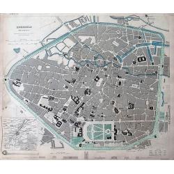
Brussels (Bruxelles)
Highly detailed town plan of Brussels, with profile views of 8 principal buildings and a smaller map of the environs of Brussels. With street names, buildings, parks, etc...
Place & Date: London, 1837
Selling price: $30
Sold in 2011
Plan de Bruxelles et de ses Faubourgs.
A very detailed city plan of Brussels and its suburbs, with a route map of its surroundings and postal routes from Brussels to The Hague.The map was produced by J.B.D.B a...
Place & Date: Paris, 1837
Selling price: $241
Sold in 2017
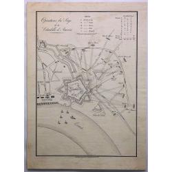
Operations du Siege de la Citadelle d'Anvers.
A fine engraving of the siege of Antwerp, Belgium in 1832. The citadel of Antwerp, also known as the South Castle, is a citadel and fortress which was located to the sout...
Place & Date: Amsterdam, ca. 1840
Selling price: $17
Sold in 2019
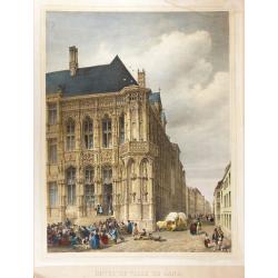
Hôtel-de-ville de Gand
Beautiful hand-colored lithograph of the Ghent city hall, by Gustave Adolphe Simonau.One of Europe's greatest nineteenth century architectural artists, Gustave Adolphe Si...
Place & Date: Brussels, 1843
Selling price: $300
Sold in 2009
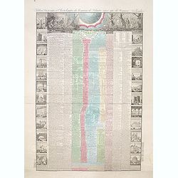
Tableau historique et chronologique du Royaume de Belgique ainsi que du Royaume Neerlandais depuis la plus haute antiquité jusqu'à nos jours
According to the text below, an "Nouvelle edition" of the decorative sheet giving a historical overview of the history of Belgium and events in the Netherlands.
Place & Date: Paris, 1845
Selling price: $50
Sold in 2014
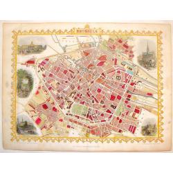
Brussels.
Striking hand-colored town plan of Tallis's "Brussels". It features vignettes of hotel de Ville, Palace royal, avenue in the Park, View from Port Anderlecht and...
Place & Date: London, 1851
Selling price: $99
Sold in 2014
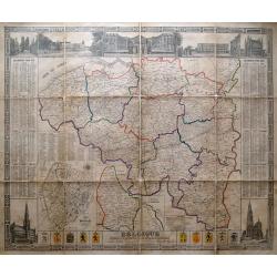
Belgique divisée en provinces et arrondissemens. . .
Scarce large size map of Belgium and Luxembourg, by D. Raes, and engraved by De Lahoese.The map is surrounded by views of important buildings, calenders of the years 1855...
Place & Date: Bruxelles, c1852
Selling price: $209
Sold in 2014
Palais du Primat à Liège.
Uncommon and decorative lithography of a scene in Luik, published by Carl Johan Billmark and printed by Lemercier in Paris, 55 rue de Seine, the leading firm in Europe at...
Place & Date: Paris, c.1859
Selling price: $20
Sold in 2020
Pays-Bas en 4 Feuilles.
Uncommon map of present-day Belgium. Engraved by P.F.Tardieu. Text engraved by Aubertz.
Place & Date: Paris, 1860
Selling price: $50
Sold in 2019
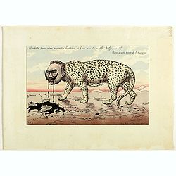
Une bête fauve rôde sur notre frontière et bave sur la noble Belgique!! Sus à cette honte de l'Europe. N°2.
Scarce plate in original hand colors figuring Wilhelm II as a wild beast walking along the French border and drooling on Belgium. Signed and dated in the plate "G. B...
Place & Date: Paris, 1914
Selling price: $500
Sold in 2018
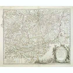
Carte du Comté de Flandre, suivant les nouvelles observations..
Including Belgium and Brabant. With decorative title cartouche lower right corner.This example is unusual in having the additional separately engraved decorative framewor...
Place & Date: Amsterdam 1728
Selling price: $120
Sold
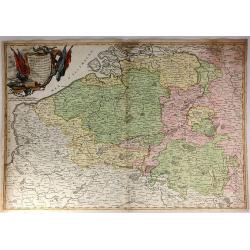
Les Comtez de Hainaut, de Cambresis, et Partie du Comté de Namur..
Uncommon map showing southern Belgium provinces south of Brussels and published by Crepy.Including the towns of Lille, Brussels, Namen, Dinant, Cambray, Mons, etc.
Place & Date: Paris, 1735
Selling price: $300
Sold in 2015
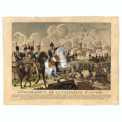
Bombardement de la Citadelle d'Anvers.
Engraving showing the attack of the citadel of Antwerp in November 1832.
Place & Date: Paris
Selling price: $20
Sold in 2016
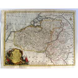
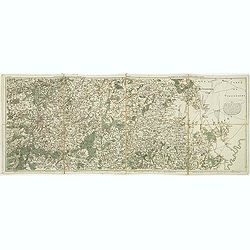
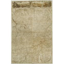
![[Bottom of Very Large Map] The Duchy of Brabant.](/uploads/cache/98717-250x250.jpg)
[Bottom of Very Large Map] The Duchy of Brabant.
This the bottom of a very large English map showing the following regions: Duchy of Brabant, Luxemburg, Duchy of Limburg, Bishoprick, French Flanders, County of Artois, C...
Place & Date: Unknown
Selling price: $32
Sold in 2017
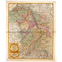
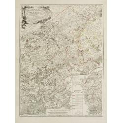
Carte de la principauté de Liege et de ses environs..
Map of present-day Dutch and Belgium Brabant and Liege, with an imposing title cartouche Carte de la pricipauté de Liége et de ses environs tirée des observations fait...
Place & Date: Liege, ca.1748
Selling price: $450
Sold