Browse Listings in Europe
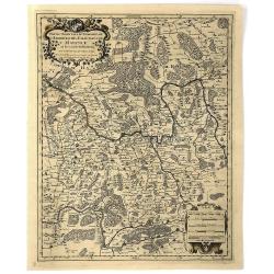
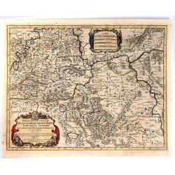
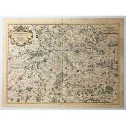
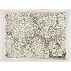
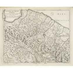
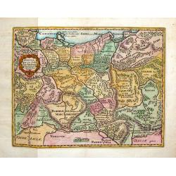
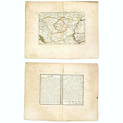
Partie Orientale du Temporel de l'Archevesché et Eslectorat de Mayence et le Comte de Remeck.
An attractive map of the eastern part of the Electorate of Mainz (Mayence) and the counties of Wertheim, Reinecke and Wuerzburch. Embellished with a large title and scale...
Date: Paris, 1696
Selling price: ????
Please login to see price!
Sold in 2019
Partie Occidentale du Temporel de l'Archevesché et Eslectorat de Treves
A fine map centred on Trier and the river Meuse, with its wine region. A figurative title cartouche in upper part and scale cartouche. By N. Sanson in 1692 from “ Les A...
Date: Paris, 1696
Selling price: ????
Please login to see price!
Sold in 2016
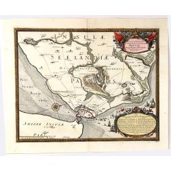
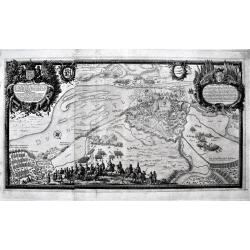
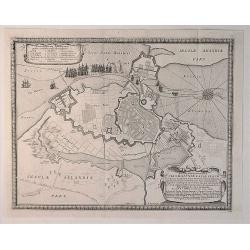
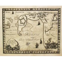
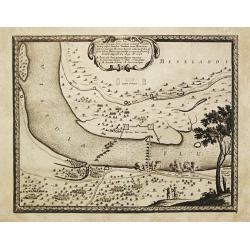
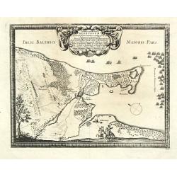
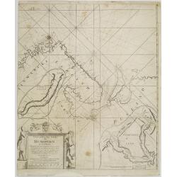
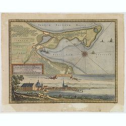
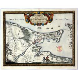
Accurata Delineatio Castrorum Suecicorum ut et Haffniae
A bird’s-eye view of an important battle for the defending of Copenhagen, Denmark. With very attractive decorative cartouches, a compass rose, and a border and featurin...
Date: Nuremburg, 1696
Selling price: ????
Please login to see price!
Sold in 2016
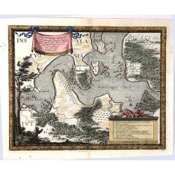
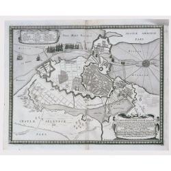
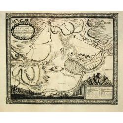
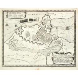
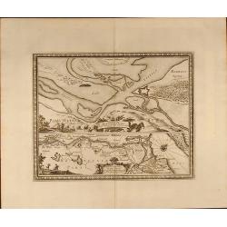
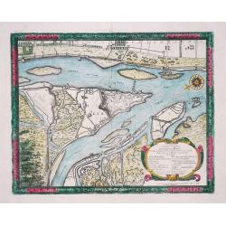
Accurata Delineatio Oppugnatae a Federatis, Caesareis, Polonicis, Danicis...
This beautiful bird’s-eye map shows part of the Danish island of Fyn and Jutland with Swedish, Polish and Danish forces in the Baltic. A lettered key identifies 12 loca...
Date: Nuremburg, 1696
Selling price: ????
Please login to see price!
Sold in 2016
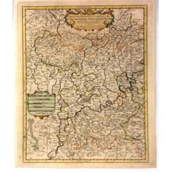
Occidentale du Palatinat et Eslectorat du Rhein Le Duché de Simmeren . . ..
A detailed map of the eastern Rheinpfalz, the immediate area around Heidelberg and Mannheim, reaching to Kaiserslautern, Gernsheim, Heilbronn and Karlsruhe. With a decora...
Date: Paris, 1696
Selling price: ????
Please login to see price!
Sold in 2016
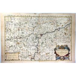
Comte de Namur Dresse sur les Memoires les Plus Nouveaux Presente a sa Majeste.
A fine, large, and detailed map of the area around the city of Namur in the province of Wallonia, in southern Belgium.From Jaillot’s “Nouvelle Introduction a le Geogr...
Date: Paris, 1696
Selling price: ????
Please login to see price!
Sold in 2017
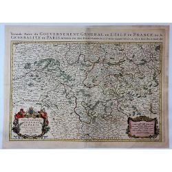
Gouvernement Generalite de Paris Divisee en Eslections.
A fine and detailed map of the region southeast of Paris between Orleans, Troyes and Nevers. From Jaillot’s “Nouvelle Introduction a le Geographie....” Embellished ...
Date: Paris, 1696
Selling price: ????
Please login to see price!
Sold in 2017
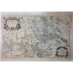
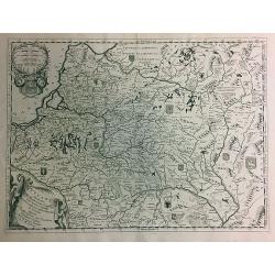
La Basse Partie du Cercle du Haute Rhein Divisee en Tous Ses Stats et Souveraintes.
A fine detailed map of the Upper Rhein region of Germany, it shows the Rhine from Cologne to Koblenz. Printed from two joined plates by Jaillot after Sanson. Title from c...
Date: Paris, 1696
Selling price: ????
Please login to see price!
Sold in 2021
Le Comte de Haynaut Divise en Chattellenies Ballages Prevoste's & c.
A fine detailed map of the Haymaut region of Belgium. It spans the area between Chatellenie to Brabant. Printed from two joined plates, by Jaillot after Sanson. Alexis-Hu...
Date: Paris, 1696
Selling price: ????
Please login to see price!
Sold in 2018
Kefalonia.
Three maps/views of Kefalonia, the largest of the Ionian islands. Includes a view of a hillside town labeled 'Cefalonia', map of the harbor of 'Argostoli', and a plan of ...
Date: Venice, 1696
Selling price: ????
Please login to see price!
Sold in 2017
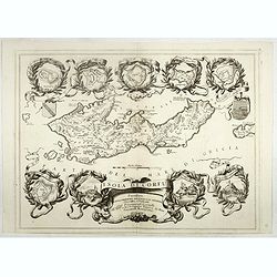
Isola di Corfu.
One of the most attractive maps of the island of Corfu ever produced. The central map is surrounded by nine plans and views of fortified locations and the ancient city of...
Date: Venice, 1696
Selling price: ????
Please login to see price!
Sold in 2019
![[Isola e Regno di Candia. . .only right hand side of this two sheet map]](/uploads/cache/40771-250x250.jpg)
[Isola e Regno di Candia. . .only right hand side of this two sheet map]
The right hand side of this very attractive detailed two sheet map of Crete within wide garland of vines incorporating the names of 100 Cretan towns, coat-of-arms of Card...
Date: Venice, 1696
Selling price: ????
Please login to see price!
Sold in 2017
Lituania dedicata all. Illustrissimo signore Gio. Pietro Caualli secretario della serenissima Republica di. . .
A rare and very attractive detailed map of Lithuania and parts of Poland and the Baltic that includes numerous coats of arms in the body of the map, and two large decorat...
Date: Venice, 1696
Selling price: ????
Please login to see price!
Sold in 2018
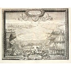
Delineatio Regiae urbis Rigae. . .
A large, detailed, and spectacular plan of Riga during the Siege of 1656. It is is filled with battles, armies, and a large number of cavalry soldiers in the foreground. ...
Date: Nuremberg, 1696
Selling price: ????
Please login to see price!
Sold in 2020
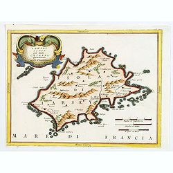
Iarsey Isola, gia detta Caesarea appartenente al Re d'Ingliterra.
An attractive small map of Jersey in the Channel Islands, with decorative cartouche from the Atlante Veneto: Isolario descrittione geografico-historia, published in Venic...
Date: Venice, 1696
Selling price: ????
Please login to see price!
Sold in 2020
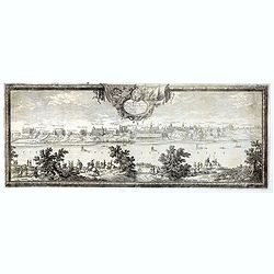
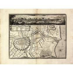
Urbs Warsavia Sedes Regum Poloniae ordinaria eo statu repraesentata quo a S.R.M. Sueciae d. 30 Aug. An.° 1655 occupabatur.
Panorama of the city of Warsaw, Poland by Erik Dahlberg who was an eye witness to the battles of Sweden against Poland and Denmark. He was the Quarter Master General of t...
Date: Nuremberg, 1696
Selling price: ????
Please login to see price!
Sold in 2019
Thorunium Primaria Prussiae Regal Urbis. . .
A decorative battle plan, showing the army of King Charles X Gustav of Sweden. Having routed the Polish armies where ever he met, them Charles X Gustav finally turned his...
Date: Nuremberg, 1696
Selling price: ????
Please login to see price!
Sold in 2019
![[2 sheets] Parte Settentrionale del' IRLANDA... [with] IRLANDA Parte Meridionale. . .](/uploads/cache/83234-250x250.jpg)
[2 sheets] Parte Settentrionale del' IRLANDA... [with] IRLANDA Parte Meridionale. . .
A matching set in contemporary Italian original color (contemporary colored maps of Coronelli are very rare on the market) of 2 attractive large folio maps depicting the ...
Date: Venice, 1696
Selling price: ????
Please login to see price!
Sold in 2019
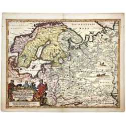
Land und see charter Schleswig vist nach Muctau. . .
An attractive and detailed map of north east Europe, with Scandinavia and part of Russia. With a striking cartouche of Merchants and Traders in local costume. Adam Oleari...
Date: Hamburg, 1696
Selling price: ????
Please login to see price!
Sold in 2020
Contado di Zara . . .
Striking map depicting the administrative territory of the Adriatic coasts taken between Istria and Albania and it represents one of the first thematic maps about the org...
Date: Venice, 1696
Selling price: ????
Please login to see price!
Sold in 2020
Marchesato del sacro impero e signoria di Malines . . .
Large-folio map of the region around the Brabant cities of Leuven, Brussels, Mechelen, Antwerp and Dendermonde. Richly decorated with cartouches and coats of arms.Vincenz...
Date: Venice, 1696
Selling price: ????
Please login to see price!
Sold in 2020
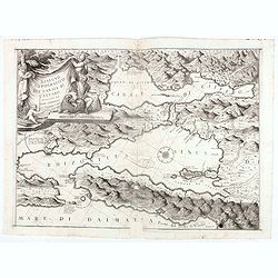
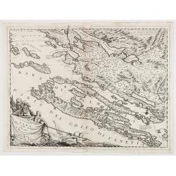
Disegno topografico del canale di Cattaro . . .
Decorative and highly detailed map of a portion of the Gulf of Venice and Sea of Dalmatia, in the Hercag-Novi region of Serbia and Montenegro. A remarkable engraving, wit...
Date: Venice, 1696
Selling price: ????
Please login to see price!
Sold in 2020
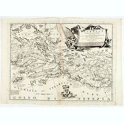
Ristretto Della Dalmazia Divisa Ne Suoi Contadi Gia Presentata Alla Serenissima Republica Di Venezia . . .
Elaborate map of the coast of Dalmatia.From Coronelli's rare Atlante Veneto, one of the most decorative and ornate of all 17th century atlases. Engraved in Coronelli's un...
Date: Venice, 1696
Selling price: ????
Please login to see price!
Sold in 2020
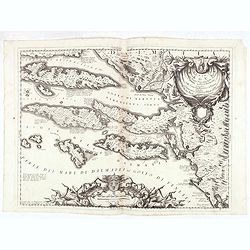
Stato di Ragusi Bocca del fiume Narenta, Isole di Lesina . . .
Map of the Republic of Dubrovnik. It shows the territory of the Republic of Dubrovnik, which included the greater Dubrovnik area comprising the mouth of the river Neretva...
Date: Venice, 1696
Selling price: ????
Please login to see price!
Sold in 2020
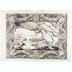
Regno di Negroponte Descritto e Dedicato al Reverendismo. P. Maestro Felice Rotondi . . .ok
A beautiful and flamboyantly engraved large-scale view of Chalkida (Halkida) with in the top right corner an inset map of the island of Evia. With a wide decorative flora...
Date: Venice, 1696
Selling price: ????
Please login to see price!
Sold in 2021
![Pianta della Forterra d'ATENE. . . [Athens]](/uploads/cache/45626-250x250.jpg)
Pianta della Forterra d'ATENE. . . [Athens]
A scarce town-plan showing the fortress and city of Athens, mainly concentrating on classical sites within the city, with a very fine separately printed border consisting...
Date: Venice, 1696
Selling price: ????
Please login to see price!
Sold in 2020
Contea dell' Artesia. Dedicata All' Illustriss, et Eccellentis: S. Bartolomeo Grimani Dal P. Coronelli.
Map of north of France, including Callais From the "Atlante Farnese". In 1683 the Venetians invaded Greece trying to wrest control from the Turks. Starting in t...
Date: Venice, 1696
Selling price: ????
Please login to see price!
Sold in 2020
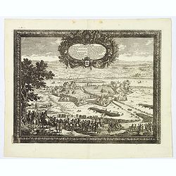
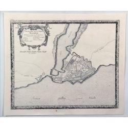
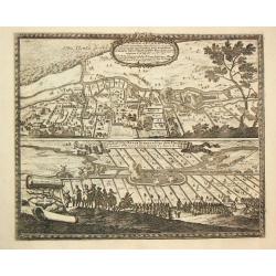
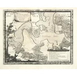
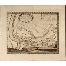
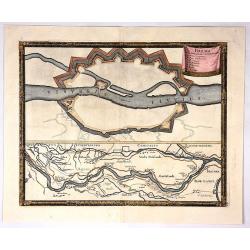
Delineatio Geometrica Urbis Haffniae Daniae Regum.
A bird's-eye plan of the important fort defending Copenhagen. The Danish navy fills the sea, and the map is adorned with decorative title and key cartouches and a detaile...
Date: Stockholm, 1696
Selling price: ????
Please login to see price!
Sold in 2020
Delineatio Geometrica Urbis Haffniæ, Daniæ Regum ...
Detailed copper engraved map featuring a panoramic view of Copenhagen, Capital of Denmark, besieged by Swedish forces from 11th (21st) August 1658. This time instead of c...
Date: Nuremburg, 1696
Selling price: ????
Please login to see price!
Sold in 2020
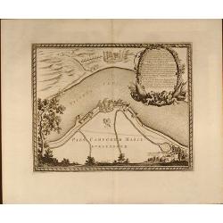
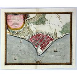
Ichnographia Areis et Oppidi Nicoplae.
A striking city map of Nykobilg, Denmark by Pufendorf in 1696. Freiherr Samuel von Pufendorf (1632–1694) was a German jurist, political philosopher, economist and histo...
Date: Stockholm, 1696
Selling price: ????
Please login to see price!
Sold in 2023
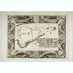
Coron. Parte del Golfo di Coron.
Map of Coron island. The map is set in an ornate border.From Coronelli's rare Atlante Veneto, one of the most decorative and ornate of all 17th century atlases. Engraved ...
Date: Venice, 1696
Selling price: ????
Please login to see price!
Sold in 2022
![[Lot of two maps of Europe]](/uploads/cache/19546-(1)-250x250.jpg)
[Lot of two maps of Europe]
An attractive large-format map of the European continent, embellished with a large title-cartouche. Newly engraved for the counterfeited edition of the ' Atlas Nouvea...
Date: Amsterdam, 1696
Selling price: ????
Please login to see price!
Sold in 2022
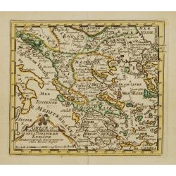
Grece ou Partie Meridionale de la Turquie en Europe..
From El atlas Abbreviado.
Date: Antwerp 1697
Selling price: ????
Please login to see price!
Sold
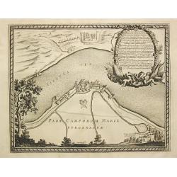
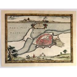
Pars Camporum Marienburgensium.
From Pufendorf's famous chronicle on the Baltic area, ' Histoire du règne de Charles Gustave, roy de Suède'. Marienburg.
Date: Nürnberg, C. Riegel, 1697
Selling price: ????
Please login to see price!
Sold in 2017
Ichnographia Castelli Pillau et adiacentium locorum Anno 1656.
From Pufendorf's famous chronicle on the Baltic area, ' Histoire du règne de Charles Gustave, roy de Suède' A decorative map of the town of Pillau (Baltiisk) on the ent...
Date: Nürnberg, C. Riegel, 1697
Selling price: ????
Please login to see price!
Sold in 2016
Castellum ad Butzfliet / Castellum vulgo Kruckschanz ad Oppidum Elmeshoorn.
From Pufendorf's famous chronicle on the Baltic area, ' Histoire du règne de Charles Gustave, roy de Suède'Two views on one sheet of fortifications on the river Elbe ne...
Date: Nürnberg, C. Riegel, 1697
Selling price: ????
Please login to see price!
Sold in 2008
Sylva Montow Werd.
From Pufendorf's famous chronicle on the Baltic area, ' Histoire du règne de Charles Gustave, roy de Suède'A print showing the crossing of the Vistal river by the Swede...
Date: Nürnberg, C. Riegel, 1697
Selling price: ????
Please login to see price!
Sold in 2009
Ichnographia Oppidi Itzehoae.
From Pufendorf's famous chronicle on the Baltic area, ' Histoire du règne de Charles Gustave, roy de Suède'A plan of the town of Itzehoae on the Stoer river.
Date: Nürnberg, C. Riegel, 1697
Selling price: ????
Please login to see price!
Sold in 2008
Baltus minor / Koldinger fiord.
From Pufendorf's famous chronicle on the Baltic area, ' Histoire du règne de Charles Gustave, roy de Suède'A map of the Lille Belt near Kolding.
Date: Nürnberg, C. Riegel, 1697
Selling price: ????
Please login to see price!
Sold in 2008
Typus Solemnitatum quibus Tabula pacis inter regna Sueciae et Daniae.
From Pufendorf's famous chronicle on the Baltic area, ' Histoire du règne de Charles Gustave, roy de Suède'
Date: Nürnberg, C. Riegel, 1697
Selling price: ????
Please login to see price!
Sold in 2008
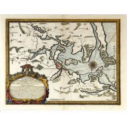
Situs locorum circa neoburgum in Fionia
From Pufendorf's famous chronicle on the Baltic area, ' Histoire du règne de Charles Gustave, roy de Suède'A map of Nyborg and vincinity on the island of Funen.
Date: Nürnberg, C. Riegel, 1697
Selling price: ????
Please login to see price!
Sold in 2010
Delineatio Geometrica Urbis Haffniae Daniae Regnum.
From Pufendorf's famous chronicle on the Baltic area, ' Histoire du règne de Charles Gustave, roy de Suède'
Date: Nürnberg, C. Riegel, 1697
Selling price: ????
Please login to see price!
Sold
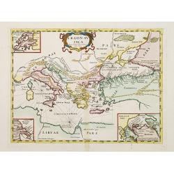
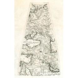
Argonautica.
A very rare map of the Mediterranean Basin, centered on Greece. Decorative title cartouche in the upper part of the map. Three inset maps in upper left-hand corner and lo...
Date: Italy 1697
Selling price: ????
Please login to see price!
Sold
Ichnographia Castelli ad Caput Vistulae vulgo Hoft Schantz.
From Pufendorf's famous chronicle on the Baltic area, ' Histoire du règne de Charles Gustave, roy de Suède'.A splendid view of the Hoft Schanz on the old and the Dantzi...
Date: Nürnberg, C. Riegel, 1697
Selling price: ????
Please login to see price!
Sold in 2017
Nieuwe gelyk-gradige Paskaart van Muskovien in grootbestek. Begrypende Noorwegen, Finmarken, Lapland en Rusland. Strekkende van Hitland tot Ysland, Beren Yland. . .
Rare sea chart map of ?Muskovien?: comprising northern parts of Norway, Finland and Russia, with insets of Kola peninsula and the course of the Archangel (Dwina) rivers. ...
Date: Amsterdam, 1697
Selling price: ????
Please login to see price!
Sold in 2008
Delineatio Regionis Vbi Wistula, et Bugus confluunt , vt et Castrorum Suedicorum
Attractive copper engraved map of view of the Wistula River, Nowy Dwor, Mazowiecki, north west of Warsaw (Warszawa) in Poland. From the famous chronicle of Baron von Pufe...
Date: Nuremberg, 1697
Selling price: ????
Please login to see price!
Sold in 2009
Delineatio Fortality Polonorum ad Lysouiam quo a Serenissimo Principe Palatino Adolpho Johanne Supremo Duce militiae Sueciae
Beautifully copper engraved plan of the region along the Vistula River opposite the village of Dirzovia, close to Malbork and Tczewa. From the famous chronicle of Baron v...
Date: Nuremberg, 1697
Selling price: ????
Please login to see price!
Sold in 2009

Situs loci in quo Situs loci in quo Sereniss: Princ. Sueciæ General.mus subito - Vistulam inter Montower Spitz et paruum Montow trajecit, cohortes Polon. fugavit, - - fluminiq. Pontem imposuit d. 4. Aug: Ao 1658
Nice copper engraved plan of the region along the Vistula River. From the famous chronicle of Baron von Pufendorf.
Date: Nuremberg, 1697
Selling price: ????
Please login to see price!
Sold in 2009
Delineatio et Situs Montower Spitze / Exquisita Delineatio Fluvii Nogat
Two copper engraved maps on one sheet. Top map showing the area Vitula River and Nogat River crossing at "Montower Spitze". The second map showing the course of...
Date: Nuremberg, 1697
Selling price: ????
Please login to see price!
Sold in 2009
Legatione del Ducato d'Urbino . . .
A uncommon, late 17th century map of part of the Urbino region, based on the reports of Giacomo Cantelli da Vignola and published in Rome by Domenico de Rossi's world atl...
Date: Rome, ca.1697
Selling price: ????
Please login to see price!
Sold in 2009
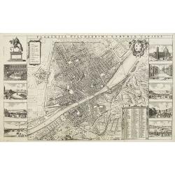
Florentia Pulcherrima et Ruriae Civitas.
Detailed bird's-eye view of the town of Florence from Frederick de Wit's rare town book. With two keys 1-17 and 1-228 to important spots in town. To the left and right on...
Date: Amsterdam, 1697
Selling price: ????
Please login to see price!
Sold in 2009
![Parte Occidentale dell' Europa,... [together with] Parte Orientale dell' Europa,...](/uploads/cache/91022-250x250.jpg)
Parte Occidentale dell' Europa,... [together with] Parte Orientale dell' Europa,...
Coronelli's double sheet map of Europe, from Atlante Veneto. Decorated with all manner of flora and fauna.
Date: Venice, 1690 - 1697
Selling price: ????
Please login to see price!
Sold in 2010
Gore sheet by Coronelli.
Gore sheet of eastern Europ and the Middle East for the big globe (110 cm in diameter) by Coronelli. Rare.
Date: Venice, 1690 - 1697
Selling price: ????
Please login to see price!
Sold in 2009
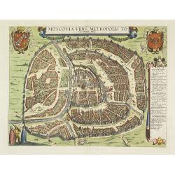
Moscovia urbs Metropolis totius Russiae Albae.
Detailed bird's-eye town-plan of Moscow from Frederick de Wit's rare townbook. With a key (1-20) to important spots in town. Frederick de Wit published after 1694 a town ...
Date: Amsterdam, 1697
Selling price: ????
Please login to see price!
Sold in 2012
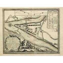
Dantiscum / Ichnographia Urbi Gedani et Castelli ad ostium Uistulae vulgo Weichselmunde.
Beautiful copper engraved map of the Vistula delta with a town plan and panoramic view of Danzig/Gdansk by S. Pufendorf. With several sailing ships and a compass rose in ...
Date: Nuremberg, 1697
Selling price: ????
Please login to see price!
Sold in 2011
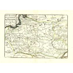
Les Estats de la Couronne de Pologne avec privilege du Roy.
Charming little map of Poland, engraved by C.Inselin and published by Nicolas de Fer.
Date: Paris, 1697
Selling price: ????
Please login to see price!
Sold in 2010
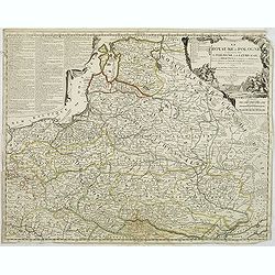
Le royaume de Pologne comprenant les états de Pologne et de Lithuanie, divisez en provinces et subdivisez en Palatinats, selon les mémoires de Starovolse, de Hartknoch. . .
Uncommon and detailed map of Poland prepared by Tillemont. Part of the Black Sea in the lower right corner.
Date: Paris, 1697
Selling price: ????
Please login to see price!
Sold in 2011
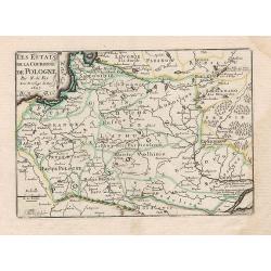
Les Estats de la Couronne de Pologne.
Charming little map of Poland, from Petit et Nouveau Atlas, engraved by C. Inselin and published by Nicolas de Fer.
Date: Paris, 1697
Selling price: ????
Please login to see price!
Sold in 2012
Neoburgum Fioniae oppidum. . .
Decorative plan and panoramic view of the town of Nyborg in Denmark at the coast of Baltic Sea in Fyn. Prepared by Count Erik Jönsson Dahlberg[h] (1625-1703). Military e...
Date: Stockholm, 1697
Selling price: ????
Please login to see price!
Sold in 2014

Saswestaholm & Sioosa.
A lovely copper engraving of two prominent buildings in Sweden by Dahlberg. There are two decorative coasts of arms held by putti. Count Erik Dahlberg (1625-1703) was a S...
Date: Stockholm, 1697
Selling price: ????
Please login to see price!
Sold in 2017

Portrait of "Guillaume III Roi".
Hand colored engraving of King William III of the Netherlands. Engraved by E. Desrochers in 1697. Prince Willen III (1650-1702) of the Netherlands became King William I ...
Date: Amsterdam, 1697
Selling price: ????
Please login to see price!
Sold in 2016
Svevia Quae Cis Coda Num Suit Sinum Antiqua Descriptio.
Fine hand colored copper engraving featuring the region that is present-day Pomerania showing the ancient germanic tribes extending to the Danube River. Adorned with a fa...
Date: Paris, 1697
Selling price: ????
Please login to see price!
Sold in 2015
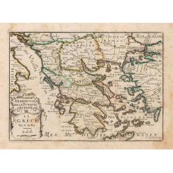
La Grece.
A map of Greece, from Petit et Nouveau Atlas, engraved by C. Inselin and published by Nicolas de Fer.It is to be noted that this particular atlas is scarcer than the othe...
Date: Paris, 1697
Selling price: ????
Please login to see price!
Sold in 2014
Geometrica Delineatio Munitionis Dantziger Hoeft.
From Pufendorf's famous chronicle on the Baltic area, ' Histoire du règne de Charles Gustave, roy de Suède'A detailed map of the fortress Dantziger Hoeft.
Date: Nürnberg, C. Riegel, 1697
Selling price: ????
Please login to see price!
Sold in 2016
Pas-caert van de Zee-custen van ENGELAND van Orfordness tot aen Flamborger Hooft.
Beautifully colored sea chart of east coast of England, oriented to the West. Early state with engraved number 22. With nice decorations of the area and two compass rose...
Date: Amsterdam, 1697
Selling price: ????
Please login to see price!
Sold in 2016
Nackschouia Lalandia Oppidium.
Old map of the Nakskov area of Denmark - Nakscoviae - by Pufendorf/ Dahlberg 1697. It is in Lolland municipality in Region Sjælland on the western coast of the island of...
Date: Sweden, 1697
Selling price: ????
Please login to see price!
Sold in 2017
Ichnogrphia Nakscoviae.
Fine decorative map from Samuel Pufendorfs large description of the Swedish King Karl X Gustav's campaign in Poland, Germany and Denmark in the years 1655-1660. Erik Dahl...
Date: Sweden, 1697
Selling price: ????
Please login to see price!
Sold in 2018
Estats de la Couronne de Pologne.
An interesting small map of Poland by Nicolas de Fer. Engraved by C.Inselin. From his rare "Petit et Nouveau Atlas". The first edition was published in 1697 and...
Date: Paris, 1697
Selling price: ????
Please login to see price!
Sold in 2017
Hongrie ou partie septent de la Turquie en Europe.
An interesting small map of Hungary and Bulgaria by Nicolas de Fer. Engraved by Inselin. From his rare "Petit et Nouveau Atlas". The first edition was published...
Date: Paris, 1697
Selling price: ????
Please login to see price!
Sold in 2018
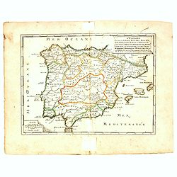
L'Espagne divisée en Galice Asturies Biscaye . . .
An interesting small map of Spain and Portugal by Nicolas de Fer. From his rare "Petit et Nouveau Atlas". The first edition was published in 1697 and was republ...
Date: Paris, 1697
Selling price: ????
Please login to see price!
Sold in 2017
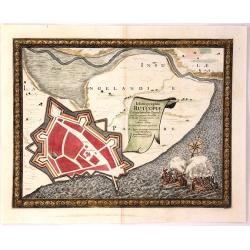
Ichnographia Rutcopiae Langelandice Oppidi
A beautifully engraved plan of the fortified town of Rutkioping on the Danish island of Langeland. Fully engraved sea with two large rowboats filled with sailors engaged ...
Date: Stockholm, 1697
Selling price: ????
Please login to see price!
Sold in 2018
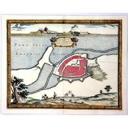
Nackschovia lulandiae Oppidum
A beautiful engraved plan of the fortified town of Nakskov Lolland Island in Demnark. Engraved on copper with a view of the fortress. With a floral title cartouche and pi...
Date: Stockholm, 1697
Selling price: ????
Please login to see price!
Sold in 2016
Situs Iocorum Circa Neoburgum in Fiona
A beautiful engraved plan of Nybirg Fyn in Demnark. Engraved on copper with a view of two men on horseback. With a decorative title cartouche and picture frame borders. A...
Date: Stockholm, 1697
Selling price: ????
Please login to see price!
Sold in 2018
Accurata Delineatio Geometrica in Luthia Friderici Oddae
A striking map of Fredericia in Demnark. Engraved on copper with a view of three ships in the sea. With a decorative drapery title cartouche and picture frame borders. A...
Date: Stockholm, 1697
Selling price: ????
Please login to see price!
Sold in 2018
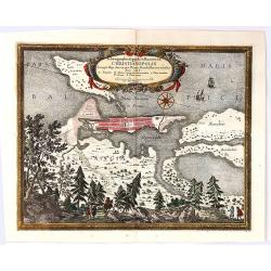
Ichnographia Oppidi et Munimenti Christianopolis ...
Kristianopel, at the eastern end of the province of Blekinge, was founded in 1603 by King Christian IV of Denmark as a defense against Swedish attacks. The province of Bl...
Date: Nuremberg, 1697
Selling price: ????
Please login to see price!
Sold in 2019
Brema.
Bremen town plan with course of the Wezer river the map is copperplate engraved with hand coloring and shows the hinterland of Bremen during the Swedish and the Bremen Th...
Date: Stockholm , 1697
Selling price: ????
Please login to see price!
Sold in 2017
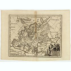
Summa Europae Antiquae descriptio.
Interesting map of Ancient Europe from Philipp Clüver's famous Introductionis in Universam geographicam, first published in Leiden in 1624. Philipp Clüver (1580–1623)...
Date: Amsterdam, 1697
Selling price: ????
Please login to see price!
Sold in 2018
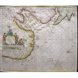
Pascaart vant Canaal Begrypende in sich Engelandt, Schotlandt, en jerlandt, als mede een gedeelt van Francryck.
Map of the English channel, oriented with east at the top and including part of France and the British isles.The beautiful title cartouche with Neptune, a river goddess a...
Date: Amsterdam, 1697
Selling price: ????
Please login to see price!
Sold in 2021
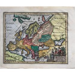
Summa Europae Antiquae descriptio.
A fascinating small map of Ancient Europe from Philipp Clüver's famous "Introductionis in Universam geographicam", which was first published in Leiden in 1624....
Date: Amsterdam, 1697
Selling price: ????
Please login to see price!
Sold in 2022
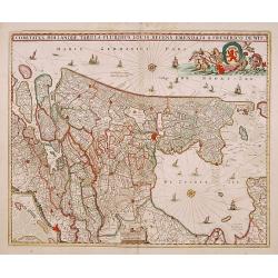
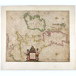
Comitatus Hollandiae tabula pluribus..
West to the top. Lower left inset of the Wadden Islands, Texel, Vlieland, Terschelling and part of Ameland.
Date: Amsterdam 1698
Selling price: ????
Please login to see price!
Sold